Click to view page images in PDF format.
Basin Evolution in Western Newfoundland: New Insights from Hydrocarbon Exploration
Mark Cooper,1 John Weissenberger,1 Ian Knight,2 Doug Hostad,3 Derek Gillespie,3 Henry Williams,4 Elliott Burden,4 Janet Porter-Chaudhry,1 Don Rae,5 Elizabeth Clark6
Search and Discovery Article #10019 (2001)
Adapted for online presentation from article of same title by same authors published in AAPG Bulletin, v. 85, No. 3 (March 2001), p. 393-418.
1PanCanadian Petroleum, 150 9th
Avenue SW, Calgary, Alberta T2P 2S5, Canada ([email protected])
([email protected])
([email protected])
2Newfoundland Department of Mines and Energy, P. O. Box 8700,
St. John's, Newfoundland, A1B 4J6, Canada ([email protected])
3Hunt Oil, Suite 3300, 205-5th Avenue SW, Calgary, Alberta T2P TV7,
Canada ([email protected]) ([email protected])
4Memorial University of Newfoundland, St. John's, Newfoundland, A1B
3X5, Canada ([email protected]) ([email protected])
5Mobil Oil Canada, 330 5th Avenue SW, Box 800, Calgary, Alberta T2P
2J7, Canada; email: [email protected]
6AEC Oil & Gas, 3700, 707 8th Avenue SW, Calgary, Alberta T2P
1H5, Canada; email: [email protected]
The Humber zone is the most external zone of the Appalachian orogen in western Newfoundland. It records multiphase deformation of the Cambrian-Ordovician passive margin and of the Ordovician to Devonian foreland basins by the Taconian, Salinian, and Acadian orogenic events.
The recent phase of exploration drilling has provided new evidence for structural, stratigraphic, reservoir, and source rock maturation models of western Newfoundland. The first well, Port au Port 1, supported the hypothesis that the Round Head thrust had an earlier extensional history prior to the Acadian compressional inversion that created the present-day structural high of the Port au Port Peninsula. The well tested a small anticline formed in a footwall shortcut fault of the Round Head thrust. The second well, Long Point M-16, was drilled at the northern tip of Long Point to test a triangle zone identified by previous workers. This well demonstrates that the frontal monocline at the western edge of the triangle zone is elevated by a stack of imbricate thrusts composed of rocks of the Taconian allochthon and compressional basement-involved faults that have uplifted the Cambrian-Ordovician carbonate platform.
The structural model developed in the Port au Port area with the aid of these wells has been extended throughout the Humber zone in western Newfoundland. Changes in structural style illustrated by regional cross sections suggest that prospective trap geometries are only developed in the southern and central parts of the region.
The reservoir model proposed invokes exposure and karsting of the footwalls of extensional faults formed as the carbonate platform collapsed during a Middle Ordovician hiatus, the St. George unconformity. Structural relief became more pronounced as extensional collapse continued through the Middle Ordovician. These structurally high fault footwalls became the foci for dolomitizing and mineralizing fluids that used major faults as fluid conduits during the Devonian. Fluids deposited sulphide ores and created zebra and sparry dolomite and some sucrosic hydrothermal dolomites in the St. George Group and the Table Point Formation.
The reservoir model, maturity and source rock data, and the structural models have been combined with seismic and onshore surface geology. This enables the prospectivity of the western Newfoundland Cambrian-Ordovician play trend to be evaluated for further exploration.
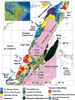 Figure
1. Surface geology compilation map of western Newfoundland based on work by
Knight (1991, 1994), Stockmal and Waldron (1993), Palmer (1995), and H.Williams
and Cawood (1989). The locations of regional structural cross sections are
indicated. HA = Humber Arm; PP = Parson's Pond; DHM = Daniel's Harbour Mine; OP
= Old Mans Pond.
Figure
1. Surface geology compilation map of western Newfoundland based on work by
Knight (1991, 1994), Stockmal and Waldron (1993), Palmer (1995), and H.Williams
and Cawood (1989). The locations of regional structural cross sections are
indicated. HA = Humber Arm; PP = Parson's Pond; DHM = Daniel's Harbour Mine; OP
= Old Mans Pond.
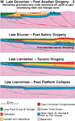
 Figure
2. Chronostratigraphic summary diagram of western Newfoundland Paleozoic
strata. Lithostratigraphic units are colored, and the ornamentation indicates
the dominant lithology. The age ranges of the megasequences defined are shown to
the right of the geological stages; SRMS = synrift megasequence; FBMS = flexural
bulge megasequence; TFBMS = Taconic foreland basin megasequence; SFBMS = Salinic
foreland basin megasequence; SBMS = successor basin megasequence; DCM = Devil's
Cove member of the Forteau Formation. Dating of the strata is based on
paleontological data from James and Stevens (1986), Botsford (1987), S.H.
Williams et al. (1987), S.H. Williams and Stevens (1988), Stenzel et al. (1990),
Knight and Cawood (1991), Knight et al. (1991), Stait and Barnes (1991), Cowan
and James (1993), and Burden and Williams (1995, 1996). The time scale used is
that of Tucker and McKerrow (1995). Additional stratigraphic data from Schuchert
and Dunbar (1934), Betz (1939), Weitz (1953), Stevens (1965), Brueckner (1966),
Klappa et al. (1980), Hiscott et al. (1984), H. Williams et al. (1985a, b),
Botsford (1987), and Knight and Boyce (1991).
Figure
2. Chronostratigraphic summary diagram of western Newfoundland Paleozoic
strata. Lithostratigraphic units are colored, and the ornamentation indicates
the dominant lithology. The age ranges of the megasequences defined are shown to
the right of the geological stages; SRMS = synrift megasequence; FBMS = flexural
bulge megasequence; TFBMS = Taconic foreland basin megasequence; SFBMS = Salinic
foreland basin megasequence; SBMS = successor basin megasequence; DCM = Devil's
Cove member of the Forteau Formation. Dating of the strata is based on
paleontological data from James and Stevens (1986), Botsford (1987), S.H.
Williams et al. (1987), S.H. Williams and Stevens (1988), Stenzel et al. (1990),
Knight and Cawood (1991), Knight et al. (1991), Stait and Barnes (1991), Cowan
and James (1993), and Burden and Williams (1995, 1996). The time scale used is
that of Tucker and McKerrow (1995). Additional stratigraphic data from Schuchert
and Dunbar (1934), Betz (1939), Weitz (1953), Stevens (1965), Brueckner (1966),
Klappa et al. (1980), Hiscott et al. (1984), H. Williams et al. (1985a, b),
Botsford (1987), and Knight and Boyce (1991).


Click here for sequence of Figure 5 and Figure 12 (structure map).
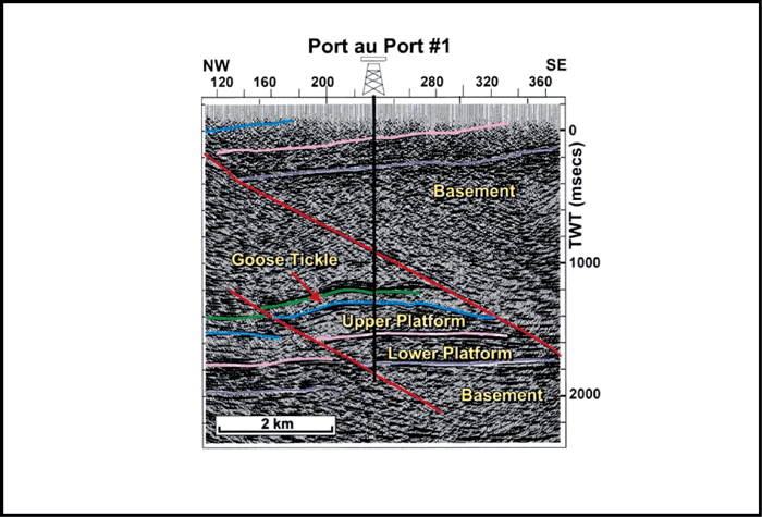
 Figure
6. Seismic line HOC-TER-CAH-93-5 showing the structure tested by the Port au
Port 1 well. Green = base Lourdes Formation; blue = top Table Point Formation;
pink = Campbells Member, Petit Jardin Formation; lilac = top basement. Faults
are shown in red. For line location, see Figure 5.
Figure
6. Seismic line HOC-TER-CAH-93-5 showing the structure tested by the Port au
Port 1 well. Green = base Lourdes Formation; blue = top Table Point Formation;
pink = Campbells Member, Petit Jardin Formation; lilac = top basement. Faults
are shown in red. For line location, see Figure 5.
Click here for sequence of Figure 6 and Figure 7 (cross section).

Click here for sequence of Figure 7 and Figure 6 (seismic line).
 Figure
8. Seismic line CHA-92-1B; for location see Figure 5 and for legend see
Figure 6 caption. The yellow horizons are unknown seismic events in the Humber
Arm allochthon that are included to show the internal geometry of the triangle
zone. See Figure 5 for location and Figure 6 caption for legend.
Figure
8. Seismic line CHA-92-1B; for location see Figure 5 and for legend see
Figure 6 caption. The yellow horizons are unknown seismic events in the Humber
Arm allochthon that are included to show the internal geometry of the triangle
zone. See Figure 5 for location and Figure 6 caption for legend.

Click here for sequence of Figure 9 and Figure 11b (seismic- line drawing).
Click here for evolutionary stages in sequence.

Click here for sequence of Figure 11b and Figure 9 (cross section).

Click here for sequence of Figure 12 and Figure 5 (geological map).
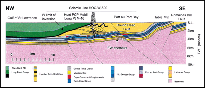
 Figure
13. Regional cross sections to illustrate structural style variations. The
cross sections are described in the text. See Figures 1 and
5 for locations.
Figure
13. Regional cross sections to illustrate structural style variations. The
cross sections are described in the text. See Figures 1 and
5 for locations.
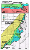 Figure
14. Structural trap fairways in the Humber zone of western Newfoundland.
Figure
14. Structural trap fairways in the Humber zone of western Newfoundland.

 Figure
16. Log correlation of stratigraphic
formations between the St. George's Bay A-36, Port au Port 1, and Long Point
M-16 wells. MD = measured depth in meters; GR = gamma ray in API units; DT =
sonic in microsecs/meter; GAS = total mud gas in units; f
= porosity % (blue = water-filled; green = oil-filled); LITH = calculated
lithology (green = shale; blue = limestone; pink = dolomite). Locations of cores
and DST intervals are shown. See Figure 5 for line of section.
Figure
16. Log correlation of stratigraphic
formations between the St. George's Bay A-36, Port au Port 1, and Long Point
M-16 wells. MD = measured depth in meters; GR = gamma ray in API units; DT =
sonic in microsecs/meter; GAS = total mud gas in units; f
= porosity % (blue = water-filled; green = oil-filled); LITH = calculated
lithology (green = shale; blue = limestone; pink = dolomite). Locations of cores
and DST intervals are shown. See Figure 5 for line of section.
 Figure
18. Production test rates and pressures,
Aguathuna Formation, Port au Port 1 well.
Figure
18. Production test rates and pressures,
Aguathuna Formation, Port au Port 1 well.
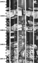 Figure
19. Zebra dolomites on an FMI log from the Watts Bight Formation, St.
George's Bay A-36 well.
Figure
19. Zebra dolomites on an FMI log from the Watts Bight Formation, St.
George's Bay A-36 well.

Click here for development of reservoir in sequence.

 Figure
22. Maturity data from the St. George's Bay A-36, Port au Port 1, and Long
Point M-16 wells datumed on the top of the Table Point Formation. See Figure
5 for well locations.
Figure
22. Maturity data from the St. George's Bay A-36, Port au Port 1, and Long
Point M-16 wells datumed on the top of the Table Point Formation. See Figure
5 for well locations.


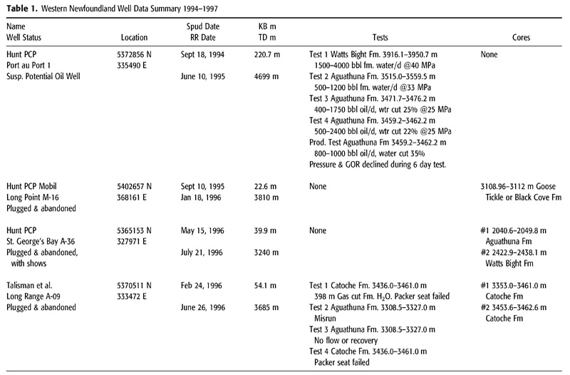
Table 1. Western Newfoundland well data summary 1994-1997.
Stratigraphy and Basin Evolution
Taconic Foreland Basin Megasequence
Salinic foreland Basin Megasequence
Predrill Exploration Play Concept
Postdrill structural Models of Hydrocarbon Traps in the Humber zone
Structural Model of the Port au Port Area
Reservoir Distribution and Development
Stratigraphy and Lithofacies of Reservoir Units
Dolomitization Processes and Evidence of Karst
Reservoir Quality in the Wells
Hydrocarbon Generation and Migration
Maturity Data and Burial History
Introduction
Geological Setting
Western Newfoundland lies within the northeast Canadian Appalachians (Figure 1), where it has been affected by several orogenic events in a complex geological history, punctuated by the opening and closing of the Iapetus Ocean. The Canadian Appalachians have been subdivided into five tectono-stratigraphic domains by H. Williams (1979); the westernmost domain, the Humber zone, includes western Newfoundland and the northern GaspÚ Peninsula in Quebec.
We divide the Paleozoic strata of the Humber zone into six tectono-stratigraphic megasequences (Figure 2).
- Siliciclastic synrift sediments (Late Proterozoic-Early Cambrian) deposited as the Iapetus Ocean formed
- Passive margin strata (latest Early Cambrian-Early Ordovician) that have shallow water carbonates passing eastward into basinal shales
- Development of a flexural forebulge of the Taconic foreland basin that migrated westward through the region during latest Early Ordovician and the earliest Middle Ordovician, creating the St. George unconformity (Knight et al., 1991). A Middle Ordovician sequence of subtidal carbonates and shales was deposited in this early Taconic foreland basin.
- Culmination of the Taconic orogeny resulting in the westward overthrusting of basinal sediments (e.g., Humber Arm allochthon) and ophiolites (e.g., Bay of Islands complex). Siliciclastic shallow marine sediments were deposited in the quiescent Taconic foreland basin (Late Ordovician to Salinic) and onlapped the Taconic allochthons.
- Imbrication of the Taconic allochthon during the Silurian Salinic orogeny that caused additional displacement toward the west (Cawood et al., 1994) and exposure and erosion of the metamorphosed hinterland sedimentation in the Salinic foreland basin and deformation of the eastern Cambrian-Ordovician carbonate platform
- Transtensional dextral reactivation of preexisting basement faults (Bradley, 1982) following the compressional deformation of the Late Devonian Acadian orogeny, creating successor basins having thick Carboniferous clastic fill (e.g., Deer Lake and St. George's Bay basins, Figure 1) (Knight, 1983)
The Acadian orogeny created a triangle zone located offshore (Cawood and Williams, 1988; Waldron and Stockmal, 1991, 1994) and caused thick-skinned compressional faulting. Present-day structure preserves the Humber Arm allochthon in an elongate low, centered on the Bay of Islands and bounded to the north and east by granitic Grenville basement (Figure 1). The Grenville is overlain unconformably by the Labrador to St. George groups on the northwestern flank of the Long Range Mountains. To the south the low is bounded by a structural culmination of the Labrador, Port au Port, and St. George groups due to Acadian compressional faulting on the Port au Port Peninsula and Acadian basement-cored, faulted anticlines immediately north of St. George's Bay (Figure 1).
Exploration History
Several shallow wells drilled in the 19th and early 20th centuries on the Port au Port Peninsula and at Parsons Pond (Figure 3) produced small quantities of oil that were used locally for lubricative and medicinal purposes (Department of Energy, 1989). In addition, several seeps containing live oil and bitumen staining in rocks were known from the Port au Port Peninsula, Parsons Pond, Humber Arm in the Bay of Islands, and Port aux Choix (Figure 3) (Department of Energy, 1989). Two wells drilled by Golden Eagle on Shoal Point in the 1960s (Figure 3) were both abandoned, but one well encountered minor quantities of oil. The only deep well in the region was drilled farther to the south in the Carboniferous/Devonian Anguille Group by Unocal in the 1970s.
Statement of Purpose
In this article, we discuss results from the latest round of hydrocarbon exploration in the area, including three exploration wells and both onshore and offshore seismic data. These data have allowed refinement of the stratigraphic and structural relationships, which we present in the context of a proposed sequence stratigraphic framework. We also present a revised model for the structure of the Port au Port Peninsula and adjacent areas and comment on potential hydrocarbon trap configurations. One of the major contributions of this article is a revised model of reservoir development in the play fairway based on the integration of the structural, stratigraphic, sedimentological, and petrophysical data from the exploration wells. Finally, we propose a model for source rock maturation and hydrocarbon migration on the Port au Port Peninsula.
The insights gained from the exploration activities have thus resulted in a comprehensive understanding of the key elements of the Cambrian-Ordovician play in western Newfoundland. The future of successful exploration within the Humber zone will depend on the application and modification of the play concepts presented within this article.
Stratigraphy and Basin Evolution
The stratigraphic relationships in western Newfoundland are complicated by phases of tectonism in the Ordovician (Taconic: H. Williams and Stevens, 1974), Silurian (Salinic: Dunning et al., 1990), and Devonian (Acadian: Cawood and Williams, 1988), that juxtapose coeval, highly diverse strata originally tens of kilometers apart. The resulting plethora of stratigraphic nomenclature has only been unraveled by detailed stratigraphic and paleontological analysis (James and Stevens, 1986; Botsford, 1987; Cowan and James, 1993; S.H. Williams et al., 1987; S.H. Williams and Stevens, 1988; Stenzel et al., 1990; Knight and Cawood, 1991; Knight et al., 1991; Stait and Barnes, 1991). We describe the stratigraphy of western Newfoundland using a proposed sequence stratigraphic framework: megasequences based on the major tectonic events and their related unconformities. We adhere to established lithostratigraphic nomenclature but discuss the stratigraphy in time sequence on a palinspastically restored base (Figure 2). The chronostratigraphic summary diagram in Figure 2 has been compiled from published data and proprietary information from recently drilled wells.
Synrift Megasequence
The synrift megasequence (SRMS) comprises the lower part of the Labrador Group. These sediments were deposited as accommodation space was created during the rifting of the Iapetus Ocean (Late Proterozoic-Early Cambrian) causing rapid thickness changes (Knight and Cawood, 1991, figure 16). The Bradore Formation is much thicker in the Round Head thrust hanging wall (Port au Port 1 well) than in the outcrops 50 km east. The base of the arkosic, poorly fossiliferous Bradore Formation is an unconformity and a regional seismic reflector (the lilac reflector in Figure 2). The oldest known rocks above this unconformity are 620 Ma, based on radiometric dating of volcanics in correlative metamorphosed strata from the Taconic allochthon to the east (H. Williams et al., 1985a). The upper boundary of the SRMS is placed at the base of the Forteau Formation. The equivalent basinal strata in the SRMS include the lower Curling Group (Figure 2), preserved only in the Humber Arm allochthon.
Passive Margin Megasequence
The passive margin megasequence (PMMS) (Figure 2) commences with the Forteau Formation, which marks progressive upward-deepening from shallow marine reefal limestones (Devil's Cove member) into deeper marine shales, reflecting thermal subsidence following cessation of active rifting (H. Williams and Hiscott, 1987). This is overlain by shallow marine sands (Hawke Bay Formation), passing eastward into basinal shales, thin sandstone turbidites, and thick channel-bound quartz arenites of the Penguin Cove, upper Summerside, and Irishtown formations.
The upper PMMS is mostly carbonates-the Cambrian Port au Port Group (Chow and James, 1987), and the Early Ordovician St. George Group (Knight and James, 1987)-representing a transgressive termination of siliciclastic deposition. These strata record cycles of changing water depth on the carbonate platform, and one of the intercalated shaly carbonates, representing successive floodings of the platform in the Petit Jardin Formation, produces a good seismic reflector (pink reflector in Figure 2). The St. George Group contains a disconformity representing a 1-2 m.y. depositional hiatus within the upper Boat Harbour Formation (Knight et al., 1991) (Figure 2).
St. George Group proximal foreslope equivalents (Cow Head Group) (James and Stevens, 1986), including spectacular platform-derived debris flows, crop out at Cow Head and at other coastal localities in and around Gros Morne National Park (Figures 1, 3). The equivalent basinal strata of the PMMS crop out in the Humber Arm allochthon (Cooks Brook and Middle Arm Point formations). These have been transported at least 100 km to the west from their site of deposition (Stockmal et al., 1995a).
Flexural Bulge Megasequence
The St. George unconformity marks the end of the stable platform and base of the flexural bulge megasequence (FBMS). This unconformity represents an hiatus of 3-4 m.y. on the Port au Port Peninsula and coincides with a major eustatic sea level drop (Sauk III/Tippecanoe). The collapse of the platform during the FBMS by extensional faulting is thought to be due to the migration of the Taconic peripheral bulge (Jacobi, 1981; Knight et al., 1991). The unconformity is recognized as far north as Greenland and south to Quebec (Knight et al., 1991).
Dolines above and below the unconformity and peritidal dolo-laminites above the unconformity, previously interpreted as upper Aguathuna Formation but here included in the Table Head Group, create a locally complex stratigraphy (Knight et al., 1991). Specific debris beds (e.g., 12 and 14) in the Cow Head Group (James and Stevens, 1986) may be related to the unconformity (Knight et al., 1991).
The Table Head Group represents progressive deepening from shallow to deep subtidal limestones infilling the karsted paleorelief at the St. George unconformity (Stenzel et al., 1990). The continued westward advance of the Taconic orogenic belt enhanced the extensional block fault collapse of the platform. The Cape Cormorant Formation conglomerates were deposited as submarine talus fans, containing clasts as old as Cambrian, adjacent to active fault scarps. They pass upward and eastward into a starved basin dominated by coeval deep marine shales and thin limestones (Table Cove Formation) representing the final collapse and drowning of the carbonate platform (Stenzel et al., 1990). The Table Head Group is overlain by the Goose Tickle Group, a dominantly muddy Taconic flysch that includes the Mainland Sandstone (Stenzel et al., 1990) (Figure 4).
Significant observations from the footwall of the Round Head thrust in the Port au Port 1 well are (1) the Cape Cormorant conglomerate is absent, and (2) the Goose Tickle and Table Head groups are thinner (185 and 15 m, respectively) than on the west coast of the Port au Port Peninsula (at least 1000 m) (Quinn, 1995; Stenzel et al., 1990) (Figure 4). These thicknesses suggest the Round Head thrust originally had an extensional offset of at least 1000 m by the late Llanvirnian. Significant early Ordovician extensional relief on the Round Head thrust controlling Cape Cormorant conglomerate deposition was postulated by Stenzel et al. (1990) and Waldron et al. (1993). The Port au Port 1 well confirms the early extensional history and constrains the stratigraphic thickness of these units in the footwall (Figure 4). The thick Mainland Sandstone (turbidite fan sands) (Quinn, 1995), in the immediate Round Head thrust hanging wall, represents later infill of the starved, fault-bounded basin established in the late Llanvirnian (Figure 2).
Basinal equivalents of the Table Head and lower Goose Tickle groups (Lower Head Formation) (H. Williams et al., 1985b) occur in the Humber Arm allochthon. The Lower Head Formation is a more sand-dominated flysch sequence, older than the Goose Tickle (Quinn, 1995); the earlier age is consistent with the east to west emplacement of the Humber Arm allochthon.
Taconic Foreland Basin Megasequence
The Taconic unconformity, a major hiatus (6-8 m.y.), defines the base of the Taconic foreland basin megasequence (TFBMS) and reflects the emplacement of the Taconic allochthons onto the shelf margin. The unconformity is marked by a jump in thermal maturity and biostratigraphic zonation in the Port au Port 1 well (Burden and Williams, 1995). The Taconic allochthons include the distal equivalents of the SRMS and PMMS. Sediment deformation and mixing of flysch with the indurated shales and ribbon limestones in the Humber Arm allochthon on the east shore of Port au Port Bay suggest it was emplaced subaqueously.
The shallow marine limestones of the Lourdes Formation (Figure 2) onlap the Taconic unconformity. Above are the interbedded shales, sandstones, and sparse thin limestones of the Winterhouse and Misty Point formations (Quinn, 1998), representing Taconic foreland basin fill (Figures 2, 5). The Lourdes Formation is significantly thicker (180 m) in the Port au Port 1 well than at outcrop (75 m), owing to the presence of two additional, biostratigraphically distinct members (Burden and Williams, 1995). Westward thickening, due to these additional stratigraphic units, implies eastward onlap onto the Humber Arm allochthon, rather than deposition on the eastern flank of the Taconic peripheral bulge as suggested by Stockmal et al. (1995a, figure 10).
Salinic Foreland Basin Megasequence
A major unconformity separates the TFBMS and Salinic foreland basin megasequence (SFBMS), represented by a time gap of about 20 m.y. between the Misty Point Formation and the Clam Bank Formation, although there is no obvious angular unconformity. The SFBMS includes the fluvial sands and shales of the Ludlovian-Pridolian(?) Clam Bank Formation and the red beds of the Emsian Red Island Road Formation (S. H. Williams et al., 1996).
Successor Basin Megasequence
The successor basin megasequence (SBMS) comprises the youngest preserved sediments in the area, the Carboniferous strata of the Anguille, Codroy, and Barachois groups. These include fluvial sandstones, silts, shales, and localized lacustrine source rocks that have regionally important marine evaporites. The latter developed pillows and domes in St. George's Bay (Knight 1983). The Carboniferous rests unconformably on peneplained, generally north to northwest-dipping Lower Paleozoic rocks (e.g., hanging wall of the Round Head thrust, the Port au Port Peninsula). The hiatus spans much of the Late Devonian, following the Acadian orogeny.
Predrill Exploration Play Concept
Between 1991 and 1997 a large amount of seismic data was acquired both onshore and offshore in the Humber zone of western Newfoundland, and four wells were drilled (Table 1). The predrill play concept involved the following:
- An Early Ordovician platform carbonate reservoir (Baker and Knight, 1993) that had karst enhancement of porosity beneath the St. George unconformity (Knight et al., 1991). An analog for the reservoir play concept was the Ellenburger play of west Texas (Kerans, 1989).
- Early Ordovician basinal shale source rocks in the Cow Head Group (Fowler et al., 1995) that were thrust onto the carbonate platform during the Taconic orogeny. The source kitchen was thought to lie to the north beneath Port au Port Bay.
- Footwall shortcut structural traps that formed where earlier extensional faults were inverted during the Acadian orogeny (Figure 6).
- A top seal that was provided by the tight limestones and shales of the Table Head and Goose Tickle groups.
The first well, Port au Port 1, tested a small onshore structural trap down-plunge of a larger offshore structure. The key risks impacting the success of the well were:
- The validity of the structural trap
- The maturity of the source rocks and the migration pathway for the generated hydrocarbons
- Development of reservoir rock capable of flowing hydrocarbons at commercial rates
Postdrill Structural Models of Hydrocarbon Traps in the Humber Zone
The seismic data and the Port au Port 1 and subsequent wells have substantially changed the structural interpretation of the Port au Port area. The revised model has implications for the distribution of structural trap types throughout the Humber zone in western Newfoundland.
Structural Model of the Port au Port Area
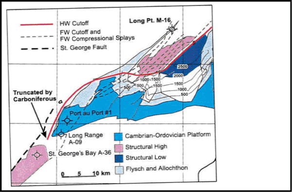
The current model of the Port au Port area has been developed by Waldron and Stockmal (1991), Waldron et al. (1993), and Stockmal and Waldron (1993). On Long Point, the Long Point Group forms the northwest-dipping limb of a monocline (Figure 5) interpreted by Waldron and Stockmal (1991) as the sequence above the roof thrust of a triangle zone. The initial interpretation of the triangle zone was that it was due to thin-skinned thrust repetition of the Cambrian-Ordovician passive margin clastic and carbonate rocks (Stockmal and Waldron, 1990). A later model suggested that the triangle zone was due to a blind, thin-skinned slice of Grenville basement and cover rocks thrust westward on a Goose Tickle detachment. In this model, the Round Head thrust was interpreted as a localized thrust reactivation of an originally extensional, basement involved fault (Stockmal and Waldron, 1993, figure 4). A later model suggests that the fault is a thick-skinned inverted extensional fault and emerges at surface as the Round Head thrust, which developed later than and offset the triangle zone (Stockmal et al., 1998). The Port au Port 1 well demonstrates that this revised model of the Round Head thrust is essentially correct. The well penetrated 615 m of granitic Grenville basement before intersecting the Round Head thrust (Figure 7), but the most significant thickness and facies changes occurred in the FBMS. As has been discussed previously, the Port au Port 1 well provides the first direct evidence for the earlier extensional history of the Round Head thrust (Figure 4) postulated by Stenzel et al. (1990) and Stockmal et al. (1998). The Port au Port 1 well also demonstrates that footwall shortcut anticlinal traps were created where the extensional faults were inverted.
The Triangle Zone
The Long Point M-16 well was directionally drilled from the northern tip of Long Point (Figure 5) eastward beneath Port au Port Bay. The well spudded in the northwest-dipping Lourdes Formation in the hanging wall of the Tea Cove thrust (Stockmal and Waldron, 1993). The nearest predrill seismic line to the well (CHA 92-1B, Figure 8) shows the northwest-dipping Long Point Group and younger strata and other subhorizontal reflectors of the Cambrian-Ordovician passive margin. Within the triangle zone are several southeast-dipping reflectors (Figure 8) that were interpreted as thin-skinned imbricates of the Humber Arm allochthon and/or the Cambrian-Ordovician platform. An alternative predrill model invoked the combination of thin-skinned deformation in the Humber Arm allochthon and thick-skinned compressional faults that elevated the Cambrian-Ordovician platform and basement.
The well penetrated a series of folds and imbricate thrusts within the Humber Arm allochthon beneath the Tea Cove thrust (Figure 9). The structural interpretation is based on the biostratigraphic data and dip and image data derived from the Formation MicroScanner (FMS) log. The FMS log was subdivided into image facies of distinctive appearance. The first is conglomeratic, having clasts of varying size suspended in a matrix and interpreted as debris flows perhaps correlative with the Cow Head Group. The second is a thin-banded multilayer interpreted as ribbon limestones in deep marine shales and perhaps correlative with the Cooks Brook or Middle Arm Point formations. The final image facies are massive, low resistivity, well-bedded units that could either be thicker sands or limestones. Distinctive sequences of image facies can be correlated using the biostratigraphic data showing a general downhole increase in age and some significant downhole shifts to younger ages, implying either fold or thrust repetition in the Humber Arm allochthon (Figure 9).
The basal thrust of the Humber Arm allochthon is visible as a shear zone on the FMS image log; beneath the basal thrust is the Goose Tickle Group. The FBMS and PMMS strata dip at 15~NW and are significantly elevated above regional elevation owing to a basement-involved compressional fault, perhaps similar in origin to the Round Head thrust (Figure 9). The Table Point Formation is 60 m thick in the well, suggesting a location off the crest of a fault footwall where the formation should be much thinner (c.f. Port au Port 1 well, Figures 4, 7). Thus the Long Point M-16 well demonstrates that the triangle zone described by Stockmal and Waldron (1990) and Waldron and Stockmal (1991) is the result of imbrication in the Humber Arm allochthon combined with thick-skinned compressional faulting. Knight and Cawood (1991) suggested that Acadian deformation to the east may have caused gravitational gliding of the Humber Arm allochthon and the overlying ophiolites into their present location (Figure 10). The deformed Taconic allochthon in the triangle zone at Long Point could be the contractional toe of this system.
Round Head Thrust
Stockmal and Waldron (1993) proposed that the Round Head thrust swung eastward beyond the Port au Port Peninsula and maintained an east-northeast trend through the northern end of Table Mountain (Figure 5). Seismic lines acquired in Port au Port Bay during our exploration program allow a fundamental reinterpretation of the Round Head thrust. The seismic data show that the Round Head thrust has an extensional offset that increases to the north in Port au Port Bay (Figure 11). We have already discussed how the Port au Port 1 well confirmed the Llanvirnian extension on the Round Head thrust that was inverted during the Acadian orogeny. We suggest that the Round Head thrust would be more appropriately named the Round Head fault. A depth structure map on the top of the carbonate platform shows that the footwall cutoff against the Round Head fault is a relatively straight line (Figure 12). The hanging-wall cutoff of the top platform against the Round Head fault trends north-northeast-south-southwest off the western coast of the Port au Port Peninsula before swinging around eastward and cutting east-northeast-west-southwest across the peninsula (Figure 5). This swing in trend is interpreted as a displacement gradient. As the fault loses displacement the hanging-wall cutoff would track eastward down the fault surface causing the hanging-wall cutoff to display a marked change in trend in map view. In West Bay, the Round Head fault abruptly loses displacement and passes through a null point just to the southwest of the tip of Shoal Point (Figure 12); to the northeast of the null point the fault is in net extension.
Outcrops of the carbonate platform on the Port au Port Peninsula fit this model. The units in the hanging wall of the Round Head fault dip northwest-north and change trend to cut across the peninsula (Figure 5). Where the carbonate platform outcrop is included as a constraint on the depth-structure map (Figure 12), no major breaks occur in the hanging wall from Port au Port Bay onto the peninsula, and the contours are compatible with the observed dips on the peninsula (H. Williams, 1985).
We conclude that the well, seismic, and surface geology data strongly suggest that the Round Head thrust is an extensional fault in Port au Port Bay that is progressively more inverted as it is traced southward onto Port au Port Peninsula. If this interpretation is correct, then local accumulations of the Cape Cormorant conglomerate are probably present at depth along the fault beneath Port au Port Bay. Compressional footwall shortcuts are still present north of the null point on the fault, despite the Round Head fault being in net extension at the top of the Table Point (Figures 5, 12), indicating that the fault system has suffered some inversion.
Regional Structural Style
To illustrate regional structural style, a series of cross sections has been constructed (Figures 1, 13) using surface geology maps (Knight, 1991, 1994) and available seismic data. The interpretation of the structural style has been influenced by the detailed data available in the Port au Port area as a result of drilling and intensive seismic data acquisition.
The southernmost section (Figure 13a) shows the footwall shortcut to the Round Head fault drilled by the St. George's Bay A-36 well and illustrates the truncation of these structures by the Carboniferous St. George's Bay Basin.
In the Old Mans Pond area (Figures 1, 13b), the Cambrian-Ordovician platform stratigraphy is deformed into a complex of folds and thrusts that locally deform the Humber Arm allochthon (Figure 13b). This thin-skinned deformation belt (Knight, 1994) is deformed by the Penguin Arm monocline developed above a basement-involved fault (Figure 13b). We suggest that the thin-skinned deformation is potentially owing to the Salinic orogeny and that the thick-skinned deformation is Acadian.
At Parsons Pond, the surface structure is dominated by imbricate thrust slices of the Lower Head Formation and Cow Head Group in the Taconic allochthon (Figures 1, 13c). The platform beneath the allochthon is deformed by a series of basement-involved faults, one of which, the Parsons Pond thrust, has been interpreted as an inverted extensional fault by Stockmal et al. (1998). These structural relationships are similar to those on the Port au Port Peninsula.
Further to the north a large number of east-dipping thick-skinned faults occur at surface (Knight, 1991) (Figure 13d). The northern end of the Long Range Mountains has a conformable overmature sequence from basement to the Ordovician carbonates, and the entire Long Range inlier could be interpreted as an overthrust sheet having subthrust, autochthonous, mature source rocks and reservoirs in the footwall. The faults are not parallel with bedding for any significant distance, thus precluding major thin-skinned overthrust displacements. The only potential location for a major thrust is in the Strait of Belle Isle. Dip and stratigraphic data onshore, however, and the seabed geology are consistent with a simple homoclinal dip panel (Sanford and Grant, 1990; Woodworth-Lynas et al., 1992), cut by a few high-angle extensional block faults (Figure 13e).
Structural Trap Configuration
The structural trap configuration tested to date in this trend is the footwall shortcut anticline developed during Acadian thick-skinned compressional deformation (Figure 14). In the case of the Round Head fault this was due to the inversion of an extensional fault developed during the SRMS and FBMS. The fairway is defined to the east and north by the eastern thrust edge of the Humber Arm allochthon; beyond this area the potential reservoir section is at surface (Figure 14). The southern edge of the fairway is defined by the outcrop of the top of the platform on the Port au Port Peninsula and the footwall cutoff of the platform against the Round Head thrust. To the west the fairway limit coincides with the western limit of Acadian thick-skinned compression that can be seen clearly on some of the offshore seismic data but has to be inferred on other lines in the data set. Further to the west extensional faults developed during the SRMS and FBMS were not inverted and retain their original extensional geometry (Figure 14). Several of these faults are visible on the offshore seismic data set used to construct the cross sections (Figure 13). The western limit of this extensional fault block fairway is not known, as structures of this type can be seen at the western ends of several lines from the offshore data set.
Reservoir Distribution and Development
Stratigraphy and Lithofacies of Reservoir Units
The primary target reservoirs are the shallowing-upward parasequences of the Cambrian-Ordovician subtidal to peritidal carbonates (Port au Port and St. George groups). In the St. George Group, the subtidal cycles are up to 5 m thick and consist of burrowed peloidal wackestones/mudstones, commonly overlain by grainy thrombolitic boundstones or parallel laminated peloidal packstones to grainstones. Cross-bedded grainstones and fenestral grainstones dominate locally, and major thrombolite-grainstone mound complexes also occur widely on the shelf. The peritidal cycles, 1 m thick, consist of thin-bedded peloidal mudstone to packstone overlain by wavy laminated, fenestral laminated to massive, or stromatolitic mudstone. In the Port au Port Group oolites are more common. Cowan and James (1993) identified six types of meter-scale cycles, three peritidal (desiccated laminite, oblate bioherm, and ribbon rock/equant bioherm) and three subtidal (ribbon rock, oolite, and large microbial bioherms). These cycles all probably represent fifth- or sixth-order parasequences.
Two third-order sequences 250-300 m thick occur in the potential reservoir section in the Port au Port area (Knight and James, 1987) (Figure 15). We pick the basal sequence boundary of the lower sequence within the stacked, small-scale peritidal parasequences in the lower Berry Head Formation (Figure 15). This represents a time of minimum accommodation on the platform (c.f. Cowan and James [1993], who defined this sequence boundary at the base of the Berry Head). The next sequence boundary is taken at the Boat Harbour disconformity (Figure 2), and the top of the younger third-order sequence is defined by the St. George unconformity.
Both third-order sequences have a similar internal facies architecture. The basal part is thin parasequences of peritidal lithofacies, the middle is mostly thicker parasequences of subtidal lithofacies, and the upper part is again dominantly peritidal. The lithostratigraphic units correspond roughly to these lithofacies; the muddy Boat Harbour and Aguathuna formations are largely peritidal lithofacies, whereas the grainier Watt's Bight and Catoche formations consist mostly of subtidal lithologies. As described in a following section, the textural attributes of these lithofacies ultimately affect reservoir quality at depth (Figure 15).
Dolomitization Processes and Evidence of Karst
Haywick (1984) identified four different types of dolomite in the St. George Group. Early dolomite was associated with inter- and supratidal environments, such as fenestral mudstones and cryptalgal laminites, probably due to periodic exposure and evaporitic conditions. Finely crystalline matrix/ mottle dolomite was identified and attributed, using crosscutting petrographic relationships with stylolites, to early burial processes. "Pervasive A" dolomite is fine to medium crystalline, coincident with the matrix/mottle phase and possibly related to mixing of marine and meteoric waters. Lastly, a phase of recrystallization, "Pervasive B" dolomite, was associated with dissolution of matrix and allochems, followed by precipitation of coarse white dolomite cements.
On the Port au Port Peninsula there is abundant dolomite in the platform outcrops but little apparent reservoir quality. The peritidal dolomites, such as those of the Aguathuna Formation, are invariably tight. Evidence for erosion, on the order of tens of meters, exists at the St. George unconformity (e.g., figure 6 in Knight et. al., 1991). Karst features such as cave-fill and solution pipes have been described by Kerans (1989) from the time-equivalent Ellenburger formation of west Texas. Discordant and bedding parallel matrix breccias support cave development in the Aguathuna Formation, and shale-filled caves are also common in the upper part of the Catoche Formation. Bedding parallel caves that have no collapse breccia or shale infill occur in the Aguathuna Formation and probably formed open caverns in the subunconformity cave system. The dolomitized subtidal lithofacies are medium gray, fine to medium crystalline dolomites that have irregular dissolution vugs ranging from 2 to 20 mm in size. Samples from the Catoche Formation have a porosity of 5% but permeability of only .06 md, indicating that the matrix is effectively tight.
Reservoir Quality in the Wells
The hanging-wall section of the Port au Port 1 well is similar to the contiguous outcrop. Log porosities in the carbonates are low, generally less than 4%, contrasting with the footwall of the Round Head fault, where several porous zones occur. The first is immediately below the St. George unconformity, in the Aguathuna Formation. The zone is 18.5 m thick and averages 9.8% porosity and 21 md permeability (Figure 16). On the FMS log there appear to be caverns (Figure 17), interpreted as karst beneath the St. George unconformity. This interval produced oil at maximum rates of 1750-2400 bbl/day and an approximate 25% water cut at pressures of 25 MPa. Several meters above and below the caverns are vuggy, sucrosic dolomites that have a possible zebra-dolomite texture. Drill cuttings contain abundant sparry white dolomite, pyrite, galena, and sphalerite. The well produced 5012 bbl of oil and 2737 bbl of water during a 7 day test at variable rates with a gradual decrease in rate and pressure (Figure 18). The origin of this drop in productivity is uncertain. It could be due to waxing and/or salt precipitation around the perforations, or it could reflect depletion of a small oil accumulation.
The underlying Catoche Formation is also extensively dolomitized but not as porous, having 15 m of 8.7% average porosity (Figure 16). Some white dolospar is present in drill cuttings, but there is no indication of lead-zinc mineralization. The interval 3515-3600 m flowed 800 bbl/day of formation water. The deepest reservoir interval is the Watts Bight Formation, between 3515 and 3559.5 m, including three cavernous zones into which 5450 bbl of drilling mud were lost (Figure 16). White dolospar, pyrite, galena, and sphalerite are common in the drill cuttings. Logs indicated porosities up to 30% (mean 14%) and no indicated hydrocarbons. The low sonic velocity and large caliper response suggested the development of three large cavernous voids, and an anomalously high-density response is interpreted as sulphide mineralization lining the void walls. The zone produced formation water at 1500-4000 bbl/day at a pressure of 40 MPa.
Reservoir development in the Long Point M-16 well is generally poorer than in Port au Port 1 (Figure 16). Both the Aguathuna and Catoche formations are tight, the latter being only slightly dolomitized. The Watts Bight Formation contains 13 m of 7% porosity, but the interval calculates wet on resistivity logs and was not tested. White dolospar was present in drill cuttings but no lead-zinc sulphides, so the zone may be more texturally analogous to the Catoche Formation in Port au Port 1.
The St. George's Bay A-36 well encountered a largely dolomitized but tight interval at the top of the carbonate platform (Figure 16). Core 1 in the Aguathuna Formation (Table 1) consists of tight, peritidal laminated mudstones to packstones that have pinpoint oilstain in the matrix and along fractures. Core 2 in the Watts Bight Formation consists of moderately porous, mostly subtidal thrombolitic boundstones that have abundant white dolospar and lead-zinc mineralization. The Watts Bight Formation contains a cavernous zone (2440-2455 m, net 8 m of 12.9% porosity) (Figure 16) that has cavernous porosity development, interpreted as zebra dolomite on the formation micro-imager (FMI) log (Figure 19). This zone caused a gas kick on penetration, but logs indicate that the zone is wet.
Reservoir Development Model
The predrill reservoir model was based on the Ellenburger play of west Texas that has a significant karst component (Kerans, 1989; Lucia, 1995). Integration of outcrop studies and the well data suggests that a paleokarst was probably relatively minor in creating the observed porosity-permeability system. The proposed reservoir model (Figure 20) is intimately related to the extensional collapse of the carbonate platform, and the dominant mechanism for reservoir quality creation is hydrothermal dolomitization.
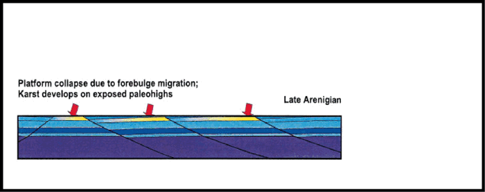
In the late Arenigian (Figure 20), the initial collapse of the platform as a series of fault-bounded blocks created the St. George unconformity. Tilting of these blocks during collapse caused some preferential subaerial erosion on the resultant topographic highs. Some dissolution and porosity enhancement probably occurred at this time, due to the solution collapse and karsting features previously described. Erosion would primarily have affected the peritidal dolomites of the Aguathuna Formation. The variable thickness of the Table Head Group (Figure 16), deposited above the unconformity, can be used to infer the relative topography of each fault block.
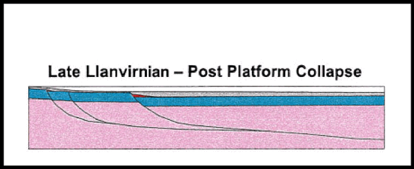
Continued foundering of the platform in the late Llanvirnian (Figure 20) caused differential subsidence of the various fault-bounded blocks. Topographic highs continued to be subaqueously eroded, and debris deposited as the Cape Cormorant conglomerate on topographically low blocks.
By the Early to Middle Devonian, the platform had been buried under the Taconic and Salinic foreland basins (Figure 20), and Acadian tectonism was occurring to the east. Hydrothermal fluids moved up major faults bounding the platform blocks at this time, an interpretation corroborated by isotopic evidence from the Daniel's Harbour mine (Figure 1), where lead-zinc mineralization in the Ordovician platform yields an Early Devonian age (Lane, 1990). Lead-zinc mineralization is seen in many areas of the eastern Port au Port Peninsula and locally in the western part. Some of this mineralization is related to Carboniferous vents (von Bitter et al., 1990; Saunders et al., 1992). A similar model of fault-focused mineralizing fluids related to Appalachian deformation has been proposed for the development of the Ozark Mississippi Valley-type lead-zinc deposits (Clendenin and Duane, 1990). The hydrothermal fluids migrated upward until impeded by a significant permeability barrier, the Goose Tickle Group. As a result, hydrothermally altered rocks are located on the paleohighs (the fault-block crests) where the hydrothermal fluids preferentially attacked the porous and permeable units in the platform, for example, the Aguathuna and Watts Bight formations.
Hydrothermal alteration (and porosity development) is greatest at the crest of fault blocks that have the thinnest development of Table Head and Goose Tickle groups, for example, in the footwall section of the Port au Port 1 well. Conversely, mineralization and porosity/permeability development is poorest in Llanvirnian paleolows (e.g., Port au Port 1 well hanging wall).
The Long Point M-16 well represents a paleolow, because of the significant thickness of Table Point Formation drilled (Figure 16) and its structural location in the hanging wall of an inverted extensional fault (Figure 9); the well encountered little porosity or permeability. The best porosity in the well was in the middle Watts Bight Formation, correlatable to the cavernous zones in the Port au Port 1 and St. George's Bay A-36 wells (Figure 16), suggesting textures susceptible to hydrothermal alteration. The St. George's Bay A-36 well encountered 70 m of the Table Point Formation circa 3 km distant from the paleohigh of the Round Head fault footwall (Figure 13a), which may explain the lack of more extensive hydrothermal alteration.
Additional evidence for the reservoir model is a large paleohigh at Port aux Choix (Figure 21). The upper part of the porous body is pervasively stained with bitumen, but the lower part is not. The base of the bitumen staining is mapped as an essentially flat contact in the field and may represent the paleo-oil-water contact of an exhumed oil field (Figure 21). The oil would have been emplaced in the Devonian, and the reservoir breached where the cap rock of Taconic/Salinic flysch was eroded, leaving the platform exposed at surface. The discovery of an exhumed oil reservoir of this size along strike from the play trend is an encouraging sign that similar traps may still exist in the subsurface.
Other Potential Reservoirs
The Port au Port 1 well encountered porous streaks (64 m of 12.2% porosity) in the clean quartz arenites of the Hawke Bay Formation in the hanging wall of the Round Head fault. In the footwall, the Hawke Bay Formation is tight, having maximum porosities of only 5%. This difference in porosity between the footwall and hanging-wall penetrations of the unit is attributed primarily to differences in the post-Acadian depth of burial that affected the amount of cementation. In the St. George's Bay A-36 well the Hawke Bay Formation had 31 m of 10% (mean) porosity but calculates wet on logs.
Hydrocarbon Generation and Migration
Source Rocks
A significant body of literature exists to identify suites of potentially rich source rocks in western Newfoundland (Macauley, 1987; Weaver and Macko, 1988; Macauley et al., 1990; Sinclair, 1990; Fowler et al., 1995). Many oils collected from old wells and seeps along the west coast of the island, and including Port au Port 1 (M. Fowler, 1977, personal communication), contain a chemical signature that is consistent with a pre-Devonian type I/II source rock containing Gloeocapsomorpha sp. (Fowler et al., 1995). The richest potential source rocks, which have total organic carbon (TOC) as high as 10%, are found in the Green Point Formation of the Humber Arm allochthon. Other physical and chemical analyses indicate Green Point strata are significant type I/II source rocks (Weaver and Macko, 1988; Fowler et al., 1995) containing Gloeocapsomorpha sp. (Fowler et al., 1995; S.H. Williams et al., 1998).
Maturity Data and Burial History
Maturity indicators in well cuttings included vitrinite reflectance, conodont color alteration index, graptolite reflectance, and acritarch color. The data show a general pattern of increasing maturity levels with depth (Figure 22) and are consistent with surface samples (S.H. Williams et al., 1998). In the Port au Port 1 well, the maturity of the Port au Port and St. George groups in the footwall and hanging wall of the Round Head thrust are identical (Figure 22), suggesting that maximum burial of this part of the platform was achieved prior to the Acadian inversion of the Round Head thrust. Maturity data from the Humber Arm allochthon and the Carboniferous on the southern shore of Port au Port Bay indicate that the strata are in the oil window (S. H. Williams et al., 1998). This suggests that the Port au Port Peninsula was covered by approximately 1-2 km of Carboniferous strata prior to (?)Mesozoic uplift and erosion.
In the Port au Port 1 and St. George's Bay A-36 wells the maturation indices show a sharp increase through the Goose Tickle Group and into the top of the carbonate platform (Figure 22). This could be interpreted as evidence for erosion of sediment at the Taconic unconformity, but the maturity data show a smooth increase through the Goose Tickle rather than a jump across the unconformity that would indicate erosion. The preferred model is that the increase in maturity is due to changes in the thermal conductivity of the strata, wherein the Goose Tickle Group acts as an aquiclude to the hydrothermal fluids, trapping heat below (Figure 23). The heat flux could only have been transmitted upward by less efficient conduction, creating a halo of elevated maturity in the Goose Tickle Group that quickly dissipated upward.
The relative consistency of maturity levels in the St. George and Port au Port groups in each of the wells drilled and at outcrop strongly suggests that Acadian deformation did not impose significant additional burial on these rocks; the most thermally mature fossils from the bottom of the Long Point M-16 well are still readily identified. As tectonic burial was occurring, synorogenic erosion must have removed uplifted strata to maintain a relatively consistent paleotopography. The analysis of apatite fission track data (Stockmal et al., 1995b) indicates a period of exhumation that ended in the early Carboniferous, following Acadian deformation. Burial of the area by 1-2 km of post-VisÚan sediment was subsequently removed by erosion (Stockmal et al., 1995b).
The proposed burial history (Figure 24) is generated as a simple Lopatin time-temperature index (TTI) model based on interpretations of the alteration indices of acritarchs (S. H. Williams et al., 1998). Models of this sort predict that once rocks enter the oil window, hydrocarbon generation may continue for many millions of years and even as uplift unroofs strata. This is not considered a valid assumption for early Paleozoic source strata. Chemistry for source rocks is not normally considered in simple burial modeling exercises. Using Ordovician Gloeocapsomorpha source strata, however, research has led to the suggestion that these rocks behave in a different manner (Reed et al., 1986). On entering the main zone of oil generation, early Paleozoic source rocks quickly produce and expel all of their hydrocarbon charge, leaving dead carbon (Horsfield et al., 1992). This leaves little or no production after this event and effectively separates the real vs. the calculated end of oil generation.
The model presented here is based on the data from the Long Point M-16 well (Burden and Williams, 1996), which penetrated the potential source rocks of the Humber Arm allochthon and bottomed in shallow marine platform carbonates of the autochthon. This model (Figure 24) proposes a variable geothermal gradient separating pretectonic and syntectonic strata that have a higher gradient (25~C) from a lower gradient characteristic of regions undergoing posttectonic crustal unloading and erosion (currently 15~C). The allochthonous strata containing the source rocks entered the oil window during the Late Devonian Acadian orogeny because of loading by the foreland basin megasequences and tectonic thickening during the development of the triangle zone. Maximum burial, maximum temperatures, and peak generation occurred during the Acadian orogeny. Inasmuch as the Lopatin model presented here predicts continued hydrocarbon generation through Mesozoic and Cenozoic uplift and erosion, most, if not all, of the hydrocarbons derived from Ordovician Gloeocapsomorpha and other algal source rocks were produced during or about the Acadian orogeny (Figure 24). Burial and juxtaposition of allochthonous source strata adjacent to autochthonous platform reservoir led to the formation of hydrocarbon pools.
Conclusions
The recent phase of exploration in the Humber zone of western Newfoundland has provided some insights into the hydrocarbon play system. The integration of well data with published information and surface outcrop studies has allowed the development of a sequence stratigraphic framework for the region. The early extensional history of the Round Head fault is now constrained by data from the Port au Port 1 and St. George's Bay A-36 wells and the seismic data from Port au Port Bay. The early extensional history of the fault is critical in the development of reservoir quality in the inherently low porosity and permeability rocks of the Cambrian-Ordovician platform. The paleohighs on the footwalls of the extensional faults were the foci of minor karst development in the Early Ordovician and later hydrothermal dolomitization during the Devonian, which significantly enhanced the porosity and permeability of shallow subtidal grainstone lithofacies in the platform succession. The extensional history of the faults also provided a migration pathway for generated hydrocarbons by juxtaposing the source rocks of the Humber Arm allochthon against the reservoir rocks of the platform. Modeling of the thermal history of the source rocks suggests that they entered the oil window during the Late Silurian as a result of deposition of the TFBMS and SFBMS just prior to the onset of the Acadian orogeny and were still within the oil window during Acadian deformation. The inversion of the extensional faults during the Acadian orogeny created compressional footwall shortcut structural traps that have been the focus of exploration drilling to date. Extensional faults that are located beyond the western limit of the Acadian compressional deformation may also be prospective exploration targets, but this play remains untested. The play fairway of Acadian compressional structures extends to just north of Parson's Pond. Farther to the north the prospective reservoir sections are exposed at surface, and hence any traps are breached. The future of successful exploration within the Humber zone will depend on the application and modification of the play concepts presented within this article; we believe that considerable potential remains in the play.
REFERENCES CITED
Baker, D., and I. Knight, 1993, The Catoche dolomite project, Anticosti basin, eastern Canada: Centre for Earth Resources Research Report, Memorial University of Newfoundland, St. John's, Newfoundland, 174 p.
Betz, E., 1939, Geology and mineral deposits of the Canada Bay area: Geological Survey of Newfoundland Bulletin 16, 53 p.
Botsford, J.W., 1987, Depositional history of Middle Cambrian to Lower Ordovician deep water sediments, Bay of Islands, western Newfoundland: Ph.D. thesis, Memorial University of Newfoundland, St. John's, Newfoundland, 534 p.
Bradley, D.C.,1982, Subsidence in Late Paleozoic basins in the northern Appalachians: Tectonics, v. 1, p. 107-123.
Brueckner, W.D., 1966, Stratigraphy and structure of west-central Newfoundland, in W. H. Poole, ed., Guidebook, geology of part of Atlantic provinces: Geological Association of Canada and Mineralogical Association of Canada Guidebook, p. 137-151.
Burden, E.T., and H. Williams, 1995, Biostratigraphy and thermal maturity of strata in Hunt-PanCanadian Port au Port well #1: Public Access Well Report, Newfoundland Department of Mines and Energy, 95 p.
Burden, E.T., and H. Williams, 1996, Biostratigraphy and thermal maturity of strata in NHOC-PCP Long Point M16: Public Access Well Report, Newfoundland Department of Mines and Energy, 75 p.
Cawood, P.A, and H. Williams, 1988, Acadian basement thrusting, crustal delamination, and structural styles in and around the Humber Arm allochthon, western Newfoundland: Geology, v. 16, p. 370-373.
Cawood, P.A; G.R. Dunning, D. Lux, and J.A.M. van Gool, 1994, Timing of peak metamorphism and deformation along the Appalachian margin of Laurentia in Newfoundland: Silurian, not Ordovician: Geology, v. 22, p. 399-402.
Chow, N. and N.P. James, 1987, Cambrian Grand Cycles: a northern Appalachian perspective: Geological Society of America Bulletin, v. 98, p. 418-429.
Clendenin, C.W., and M.J. Duane, 1990, Focused fluid flow and Ozark Mississippi Valley-type deposits: Geology, v. 18, p. 116-119.
Cowan, C.A., and N.P. James, 1993, The interactions of sea-level change, terrigenous sediment influx and carbonate productivity as controls of Upper Cambrian Grand Cycles of western Newfoundland, Canada: Geological Society of America Bulletin, v. 105, p. 1576-1590.
Department of Energy, 1989, Hydrocarbon potential of the western Newfoundland onshore area: Government of Newfoundland and Labrador, Department of Energy Report, 20 p.
Dunning, G.R., S.J. O'Brien, S.P. Colman-Sadd, R.F. Blackwood, W.L. Dickson, P.P. O'Neill, and T.E. Krogh, 1990, Silurian orogeny in the Newfoundland Appalachians: Journal of Geology, v. 98, p. 895-913.
Fowler, M.G., A.P. Hamblin, D. Hawkins, L.D. Stasiuk, and I. Knight, 1995, Petroleum geochemistry and hydrocarbon potential of Cambrian and Ordovician rocks of western Newfoundland: Bulletin of Canadian Petroleum Geology, v. 43, p. 187-213.
Haywick, D.W., 1984, Dolomite within the St. George Group (Lower Ordovician), western Newfoundland: M.Sc. thesis, Memorial University of Newfoundland, St. John's, Newfoundland, 308 p.
Hiscott, R.N., N.P. James, and S.G. Pemberton, 1984, Sedimentology and ichnology of the Lower Cambrian Bradore Formation: fluvial to shallow-marine transgressive sequence, coastal Labrador: Bulletin of Canadian Petroleum Geology, v. 32, p. 1-26.
Horsfield, B., S. Bharati, S.R. Larter, F. Leistner, R. Littke, H.J. Schenk, and H. Dypvik, 1992, On the atypical petroleum generating characteristics of alginite in the Cambrian Alum Shale, in M. Schidlowski, S. Golubic, M.M. Kimberley, D.M. McKirdy, and P.A. Trudinger, eds., Early organic evolution: implications for mineral and energy resources: Berlin, Springer-Verlag, p. 257-266.
Jacobi, R.D., 1981, Peripheral bulge-a causal mechanism for the Lower/Middle Ordovician unconformity along the western margin of the northern Appalachians: Earth and Planetary Science Letters, v. 56, p. 245-251.
James, N.P., and R.K. Stevens, 1986, Stratigraphy and correlation of the Cambro-Ordovician Cow Head Group, western Newfoundland: Geological Survey of Canada Bulletin 366, 143 p.
Kerans, C., 1989, Karst-controlled reservoir heterogeneity in Ellenburger Group carbonates of west Texas: AAPG Bulletin, v. 72, p. 1160-1183.
Klappa, C.F., P.R. Opalinski, and N.P. James, 1980, Middle Ordovician Table Head Group of western Newfoundland: a revised stratigraphy: Canadian Journal of Earth Sciences, v. 17, p. 1007-1019.
Knight, I., 1983, Geology of the Carboniferous Bay St. George Subbasin, western Newfoundland: Newfoundland Department of Mines and Energy, Mineral Development Division Memoir 1, 358 p.
Knight, I., 1991, Geology of Cambro-Ordovician in the Port Saunders (NTS 12I/ 1 1), Castors River (NTS 12I/15), St. John Island (NTS 12I/14) and Torrent River (NTS 12I/10) map areas: Newfoundland Department of Mines and Energy, Geological Survey Branch Report 91-4, 138 p.
Knight, I., 1994, Geology of Cambrian-Ordovician platformal rocks of the Pasadena map sheet (12H/4): Newfoundland Department of Mines and Energy, Geological Survey Branch Report 94-1, p. 175-186.
Knight, I., and W.D. Boyce, 1991, Deformed Lower Paleozoic platform carbonates, Goose Arm-Old Mans Pond: Current Research, Newfoundland Department of Mines and Energy Report 91-1, p. 141-153.
Knight, I., and P.A. Cawood, 1991, Paleozoic geology of western Newfoundland: an exploration of a deformed Cambro-Ordovician passive margin and foreland basin, and Carboniferous successor basin: St. John's, Newfoundland, Centre for Earth Resources Research, 403 p.
Knight, I., and N.P. James, 1987, Stratigraphy of the Lower Ordovician St. George Group, western Newfoundland: the interaction between eustasy and tectonics: Canadian Journal of Earth Science, v. 24, p. 1927-1951.
Knight, I., N.P. James, and T. E. Lane, 1991, The Ordovician St. George unconformity, northern Appalachians: the relationship of plate convergence at the St. Lawrence Promontory to the Sauk/Tippecanoe sequence boundary: Geological Society of America Bulletin, v. 103, p. 1200-1225.
Lane, T.E., 1990, Dolomitization, brecciation and zinc mineralization and their paragenetic stratigraphic and structural relationships in the upper St. George Group (Ordovician) at Daniel's Harbour, western Newfoundland: Ph.D. thesis, Memorial University of Newfoundland, St. John's, Newfoundland, 565 p.
Lucia, F.J., 1995, Lower Paleozoic cavern development, collapse and dolomitization, Franklin Mountains, El Paso, Texas, in D.A. Budd, A.H. Saller, and P.M. Harris, eds., Unconformities and porosity in carbonate strata: AAPG Memoir 62, p. 279-300.
Macauley, G., 1987, Organic geochemistry of some Ordovician outcrop samples, western Newfoundland: Geological Survey of Canada Open File Report 1503, 15 p.
Macauley, G., M. G. Fowler, E. Goodarzi, L. R. Snowdon, and L. D. Stasiuk, 1990, Ordovician oil shale-source rock sediments in the central and eastern Canada mainland and eastern Arctic areas, and their significance for frontier exploration: Geological Survey of Canada Paper 90-14, 51 p.
Palmer, S.E., 1995, Structure of deformed Paleozoic continental margin units in the Stephenville area, western Newfoundland: M.Sc. thesis, Saint Mary's University, Halifax, Nova Scotia, 173 p.
Quinn, L., 1995, Middle Ordovician foredeep fill in western Newfoundland, in J. P. Hibbard, C.R. van Stall, and P.A. Cawood, eds., Current perspectives in the Appalachian-Caledonide orogen: Geological Association of Canada Special Paper 41, p. 43-63.
Quinn, L., 1998, Detrital signatures in an evolving foreland basin: Middle Ordovician to Devonian, western Newfoundland (abs.): Annual Meeting Geological Association of Canada Abstracts, p. A151-A152.
Reed, J.D., H.A. Illich, and B. Horsfield, 1986, Biochemical evolutionary significance of Ordovician oils and their sources: Organic Geochemistry, v. 10, p. 347-358.
Sanford, B.V., and A.C. Grant, 1990, Bedrock geological mapping and basin studies in the Gulf of St. Lawrence: Geological Survey of Canada Paper 90-lB, p. 33-42.
Saunders, C.M., D.F. Strong, and D.F. Sangster, 1992, Carbonate-hosted lead-zinc eposits of western Newfoundland: Geological Survey of Canada Bulletin 419, 78 p.
Schuchert, C., and C.O. Dunbar, 1934, Stratigraphy of western Newfoundland: Geological Society of America Memoir 1, 123 p.
Sinclair, I.K., 1990, A review of the upper Precambrian and Lower Paleozoic geology of western Newfoundland and the hydrocarbon potential of the adjacent offshore area of the Gulf of St. Lawrence: Canada-Newfoundland Offshore Petroleum Board, GL-CNOPB-90-01, 57 p.
Stait, B.A., and C.R. Barnes, 1991, Stratigraphy of the Middle Ordovician Long Point Group, western Newfoundland, in C.R. Barnes and S.H. Williams, eds., Advances in Ordovician geology: Geological Survey of Canada Paper 90-9, p. 235-244.
Stenzel, S.R., I. Knight, and N. P. James, 1990, Carbonate platform to foreland basin: revised stratigraphy of the Table Head Group (Middle Ordovician), western Newfoundland: Canadian Journal of Earth Sciences, v. 27, p. 14-26.
Stevens, R.K., 1965, Geology of the Humber Arm area, west Newfoundland: M.Sc. thesis, Memorial University of Newfoundland, St. John's, Newfoundland, 121 p.
Stockmal, G.S., and J.W.F. Waldron, 1990, Structure of the Appalachian deformation front in western Newfoundland: implications of multichannel seismic reflection data: Geology, v. 18, p. 765-768.
Stockmal, G.S., and J.W.F. Waldron, 1993, Structural and tectonic evolution of the Humber zone, western Newfoundland, 1: implications of balanced cross sections through the Appalachian structural front, Port au Port Peninsula: Tectonics, v. 12, p. 1056-1075.
Stockmal, G.S., J.W.F. Waldron, and G.M. Quinlan, 1995a, Flexural modeling of Paleozoic foreland basin subsidence, offshore western Newfoundland: evidence for substantial post-Taconian thrust transport: Journal of Geology, v. 103, p. 653-671.
Stockmal, G.S., D.R. Issler, L.A. Quinn, and A. Slingsby, 1995b, Thermal maturity at the Appalachian structural front, Port au Port Peninsula, western Newfoundland: implications of inversion of apatite fission track data: Geological Survey of Canada Open File 3058, p. 509-514.
Stockmal, G.S., A. Slingsby, and J.W.F. Waldron, 1998, Deformation styles at the Appalachian structural front, western Newfoundland: implications of new industry seismic reflection data: Canadian Journal of Earth Sciences, v. 35, p. 1288-1306.
Tucker, R.D., and W. S. McKerrow, 1995, Early Paleozoic chronology: a review in light of new U-Pb zircon ages from Newfoundland and Britain: Canadian Journal of Earth Sciences, v. 32, p. 368-379.
Von Bitter, P.H., S.D. Scott, and P.E. Schenck, 1990, Early Carboniferous low temperature hydrothermal vent communities from Newfoundland: Nature, v. 344, p. 145-148.
Waldron, J.W.F., and G.S. Stockmal, 1991, Mid-Paleozoic thrusting at the Appalachian deformation front: Port au Port Peninsula, western Newfoundland: Canadian Journal of Earth Sciences, v. 28, p. 1992-2002.
Waldron, J.W.F, and G.S. Stockmal, 1994, Structural and tectonic evolution of the Humber zone, western Newfoundland, 2: geophysical and geological evidence for Acadian thrust tectonics: Tectonics, v. 13, p. 1498-1513.
Waldron, J. W.F., G.S. Stockmal, R.E. Corney, and S.R. Stenzel, 1993, Basin development and inversion at the Appalachian structural front, Port au Port Peninsula, western Newfoundland Appalachians: Canadian Journal of Earth Sciences, v. 30, p. 1759-1772.
Weaver, F.J., and S.A. Macko, 1988, Source rocks of western Newfoundland: Organic Geochemistry, v. 13, p. 411-421.
Weitz, J.L., 1953, Geology of the Bay of Islands area, western Newfoundland: Ph.D. thesis, Yale University, New Haven, Connecticut, 182 p.
Williams, H., 1979, Appalachian orogen in Canada: Canadian Journal of Earth Sciences, v. 16, p. 792-807.
Williams, H., 1985, Geology, Stephenville map area, Newfoundland: Geological Survey of Canada Map 1579A, scale 1:100,000, 1 sheet.
Williams, H., and P.A. Cawood, 1989, Geology, Humber Arm allochthon, Newfoundland: Geological Survey of Canada Map 1678A, scale 1:250,000, 1 sheet.
Williams, H., and R.N. Hiscott, 1987, Definition of the Iapetus rift-drift transition in western Newfoundland: Geology, v. 15, p. 1044-1047.
Williams, H., and R.K. Stevens, 1974, The ancient continental margin of eastern North America, in C.A. Burk and C.L. Drake, eds., The geology of continental margins: New York, Springer-Verlag, p. 781-796.
Williams, H., R.T. Gillespie, and O. Van Breemen, 1985a, A late Precambrian rift-related igneous suite in western Newfoundland: Canadian Journal of Earth Sciences, v. 22, p. 1727-1735.
Williams, H., N.P. James, and R..K. Stevens, 1985b, Humber Arm allochthon and nearby groups between Bonne Bay and Portland Creek, western Newfoundland: Geological Survey of Canada Paper 85-1A, p. 399-406
Williams, S.H., and R.K. Stevens, 1988, The Lower Ordovician (Arenig) graptolites of the Cow Head Group, western Newfoundland: Palaeontographica Canadiana 5, 167 p., 34 pl.
Williams, S.H., N.P. James, and W.D. Boyce, 1987, Graptolites from the Lower-Middle Ordovician St. George and Table Head groups, western Newfoundland, and their correlation with trilobite, brachiopod and conodont zones: Canadian Journal of Earth Sciences, v. 24, p. 456-470.
Williams, S.H., E.T. Burden, L. Quinn, P.H. Von Bitter, and A.R. Bashforth, 1996, Geology and Paleontology of the Port au Port Peninsula, W. Newfoundland: Canadian Palaeontology Conference Field Trip GB#5, Geological Association of Canada, 74 p.
Williams, S.H., E.T. Burden, and P.K. Mukhopadhyay, 1998, Thermal maturity and burial history of Paleozoic rocks in western Newfoundland: Canadian Journal of Earth Sciences, v. 35, p. 1307-1322.
Woodworth-Lynas, C.M.T., J.Y. GignÚ, and E.L. King, 1992, Surficial and bedrock geology beneath the Strait of Belle Isle in the vicinity of a proposed power-cable crossing: Newfoundland Department of Mines and Energy, Geological Survey Branch Report 92-2, 53 p.
Mark Cooper has a geology B.Sc. degree from Imperial College, London and a Ph.D. from Bristol University. He initially taught geology in London and at University College Cork. He moved to BP in 1985 and worked on structurally complex basins worldwide, including assignments to Calgary and Bogotß. He joined PanCanadian Petroleum as structural specialist in 1994 and now works on global new venture exploration. He has published over 40 papers, co-edited with G. D. Williams a book on inversion tectonics, and is an advisory editor for the Journal of the Geological Society of London.
John Weissenberger has a B.Sc. degree in geology from the University of Western Ontario and a Ph.D. from the University of Calgary on Frasnian sedimentology and conodont biostratigraphy of the west-central Alberta Rockies. He initially worked at Imperial Oil, Calgary on Devonian exploration projects. After joining PanCanadian in 1994, he worked on reservoir and stratigraphic aspects of Devonian through Triassic plays in the British Columbia Foothills and on western Newfoundland. He is currently the carbonate specialist at PanCanadian, working on exploration and development projects, conducting training, and pursuing practical research applications in carbonate sequence stratigraphy.
Ian Knight has been a project geologist at the Geological Survey of Newfoundland and Labrador for more than 25 years. His interests include the stratigraphy, sedimentology, structure, regional geology, and mapping of much of the Cambrian-Ordovician shelf sequences and Carboniferous basins of western Newfoundland.
Doug Hostad currently works as a team leader, Northern Exploration Group for Hunt Oil Company of Canada. He has over 22 years of exploration experience working Canada's Frontier basins and the Western Canada sedimentary basin. His work for Hunt has been focused primarily on petroleum system analysis and prospect generation. He is a member of the AAPG and Canadian Society of Petroleum Geologists.
Derek Gillespie has been a senior geophysicist with Hunt Oil Company since 1987. He received a B.A.Sc. degree in engineering science from the University of Toronto and started his career with Amoco in 1974. Before joining Hunt, he worked with Petrel Consultants Ltd. as a geophysical consultant both in Calgary and on several international assignments. His current focus with Hunt Oil Company of Canada is on exploration plays in central Alberta.
Henry Williams following his graduation, moved to the University of Oslo, then to Memorial University of Newfoundland, where he obtained a faculty appointment. He has been involved in the selection of global stratotype sections for both the upper and lower boundaries of the Ordovician, was secretary of the International Union of Geological Sciences Subcommission on Ordovician Stratigraphy, and has published over 50 scientific papers on lower Paleozoic stratigraphy, paleontology, and paleogeography. After completing several oil-related consulting projects, Henry left his position at Memorial University last year to begin a new career with Petro-Canada in hydrocarbon exploration and is currently investigating carbonate plays in western Alberta.
Elliott Burden received his Ph.D. in geology from the University of Calgary in 1982. In nearly 20 years at Memorial University of Newfoundland, he has combined his interests in sedimentology and palynology as a means for better understanding the rock record. Past and present projects on a variety of topics, spanning the entire Phanerozoic and covering strata in many parts of Canada and the United States, address issues surrounding resource exploration and development.
Janet Porter-Chaudhry received a B.A.Sc. degree in engineering science, geophysics option, from the University of Toronto (1986). From 1986 to 1996 she worked at Esso Resources Canada Ltd. on a variety of exploration and development projects, as well as in their processing group. She began working at PanCanadian Petroleum Ltd. in 1997 in North American frontier exploration and has since explored in a variety of areas, including western Newfoundland, Alberta and British Columbia Foothills, the Jeanne d'Arc Basin, and the Scotian Shelf. She is currently exploring in the Gulf of Mexico. Her interests are in structural interpretation and seismic imaging problems.
Don Rae is a senior geological advisor with ExxonMobil Canada based in Calgary. He graduated with B.Sc. and M.Sc. degrees from the University of Toronto. He joined Canadian Superior Mining as a mineral exploration geologist in 1972, where he worked in British Columbia, the Arctic, Ireland, Spain, and Portugal. In 1982 he transferred to Canadian Superior Oil and later Mobil Oil, working as an exploration geologist in Western Canada, South America, and a number of petroleum provinces on Canada's east coast, including west Newfoundland. He is currently part of a multidisciplinary team conducting regional exploration offshore Nova Scotia.
Elizabeth Clark received her B.Sc. degree (honors) in geophysics from the University of Manitoba in 1987 and her Ph.D. in geophysics from the University of Calgary in 1993. She worked for Mobil Oil Canada from 1993 to 2000, exploring for hydrocarbons in the Canadian Rockies foothills, western Newfoundland, and the Jeanne d'Arc Basin, offshore Newfoundland. She is now exploring for natural gas in the foothills for Alberta Energy Company.
ACKNOWLEDGMENTS
We wish to thank PanCanadian Petroleum, Hunt Oil, and Mobil Oil for permission to publish this article. Drafting was done by PentaGrafix Ltd. Early drafts of this article benefited from critical readings by John Hogg, Marian Warren, and Ian McIlreath. We thank Roland Strickland for his valuable input to the description of the well cuttings.