|
uLocation
map
uRocky
Mountains
uDenver
basin
uSan
Juan basin
uUinta
basin
uSW
Wyoming
uPowder
River basin
uBig
Horn basin
uWilliston
basin
uWestern
Canada
uAlaska
uReferences
uLocation
map
uRocky
Mountains
uDenver
basin
uSan
Juan basin
uUinta
basin
uSW
Wyoming
uPowder
River basin
uBig
Horn basin
uWilliston
basin
uWestern
Canada
uAlaska
uReferences
uLocation
map
uRocky
Mountains
uDenver
basin
uSan
Juan basin
uUinta
basin
uSW
Wyoming
uPowder
River basin
uBig
Horn basin
uWilliston
basin
uWestern
Canada
uAlaska
uReferences
uLocation
map
uRocky
Mountains
uDenver
basin
uSan
Juan basin
uUinta
basin
uSW
Wyoming
uPowder
River basin
uBig
Horn basin
uWilliston
basin
uWestern
Canada
uAlaska
uReferences
uLocation
map
uRocky
Mountains
uDenver
basin
uSan
Juan basin
uUinta
basin
uSW
Wyoming
uPowder
River basin
uBig
Horn basin
uWilliston
basin
uWestern
Canada
uAlaska
uReferences
uLocation
map
uRocky
Mountains
uDenver
basin
uSan
Juan basin
uUinta
basin
uSW
Wyoming
uPowder
River basin
uBig
Horn basin
uWilliston
basin
uWestern
Canada
uAlaska
uReferences
|
Rocky Mountains
Denver Basin and
Plains to the East and Northeast
|
 |
Figure 3. Map of Dakota artesian
aquifer, Kansas to North Dakota. Water analyses from Darton,
1896, Leonard and Berry, 1961, Swenson, 1968, Barnes et al.,
1971, McNellis, 1974, and Bayne and Ward, 1974. |
|
 |
Figure 4. Diagrammatic cross-section,
central Kansas to North Dakota, showing configuration of
“Dakota” Sandstone, potentiometric surface, and topographic
surface. |
San Juan Basin
Uinta Basin
Southwestern and
Central Wyoming
Powder River Basin
|
 |
Figure 12. Structure map, Powder River
Basin, with fields producing from Muddy Sandstone. |
|
 |
Figure 13. Southwest-northeast schematic
cross-section, Power River Basin, showing position of abnormal
pressures in the basin. |
|
 |
Figure 14. Map of Powder River Basin,
with areal extent for top of overpressures near -4000 ft and
extent for top of overpressures shallower than -4000 ft. |
|
 |
Figure 15. Map of Powder River Basin,
with areal extents of overpressures and underpressures in Lower
Cretaceous formations and overpressures in both Upper and Lower
Cretaceous formations. |
|
 |
Figure 16. Detail map for extents of
underpressured and overpressured Lower Cretaceous formations,
Powder River Basin. |
|
 |
Figure 17. Salinity, pressure
compartments, and thickness of Muddy Sandstone, northeast Powder
River Basin. |
Big Horn
Basin and South- Central Montana
|
 |
Figure 18. Pressure distribution,
Tensleep Sandstone, Big Horn Basin. |
|
 |
Figure 19. Structure map, Phosphoria
Formation, Big Horn Basin, as location map of Cottonwood
Creek field (Figure 20). |
|
 |
Figure 20. Structure map, Cottonwood
Creek field, on Phosphoria Formation, showing outline of
Cottonwood Creek fluid compartment. |
|
 |
Figure 21. Tectonic elements,
south-central Montana, as location map for Dry Creek field
in cross-section in Figure 22. |
|
 |
Figure 22. Schematic cross-section,
south-central Montana, showing normal pressures across Nye
Bowler Fault and potentiometric surface that is the same as
topographic elevation at Dry Creek field. |
Williston Basin
|
 |
Figure 23. Pre-Devonian paleogeologic
map, Rocky Mountains and environs (after Loucks, 1977). |
|
 |
Figure 24. Pre-Upper Devonian
paleogeologic map, Rocky Mountains and environs (after Loucks,
1977). |
|
 |
Figure 25. Generalized stratigraphic
chart, Williston Basin, with positions of underpressures,
overpressures, and normal pressures. |
|
 |
Figure 26. Structure map, on base of
Mississippian, Williston Basin, with southern limit of the
Bakken Formation and area of overpressures (after Meissner,
1978). |
|
 |
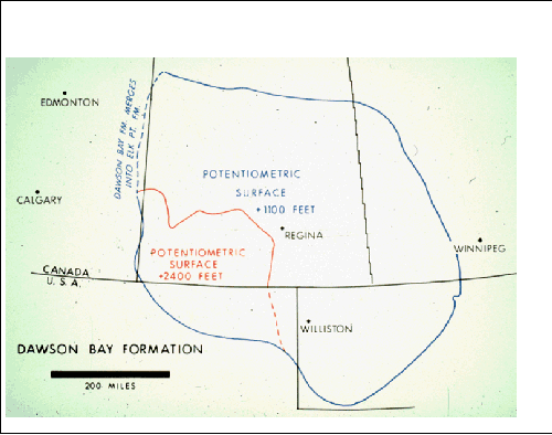
Figure 27. Map of potentiometric
surfaces, Devonian Dawson Bay Formation. |
|
 |
Figure 28. Map of potentiometric
surfaces, along with general water character, Silurian Interlake
and Siluro-Ordovician Stonewall formations. |
|
 |
Figure 29. Map of potentiometric
surfaces, along with area of low-permeable strata, Ordovician
Red River Formation. |
|
 |
Figure 30. Map of the Dakotas and
eastern Montana, showing of the boundary in the Red River
Formation that separates potentiometric surface of +1100 feet
and pressure gradient of 51.2 psi/100 feet, to the east and
northeast, from the potentiometric surface of +2400 feet and
pressure gradient of 45 psi/100 feet, to the west and southwest.
|
|
 |
Figure 31. Schematic cross-section
showing the positions of the different types of water in the Red
River Formation, along with associated potentiometric surfaces
and pressure gradients. |
|
 |
Figure 32. Map of potentiometric
surface, Ordovician Winnipeg Sandstone (from Paterson, 1971, in
part).
Click to view in sequence maps of
potentiometric surfaces (Figures 27, 28, 29, 32) |
|
 |
Figure 33. Structure map and
pressure-depth profile, Sanish oil pool, Antelope Field,
McKenzie County, North Dakota. Sanish Sandstone, a member of the
Devonian Three Forks Formation, is overpressured. |
Western Canada
Alaska
|
 |
Figure 39. Generalized cross-section of
Cook Inlet Basin, showing position of overpressures. |
|
 |
Figure 40. Map of Copper River
sedimentary province, where cross-section in
Figure 41 is located. |
|
 |
Figure 41. Generalized cross-section,
Copper River Basin, showing position of overpressured
compartment, from which fluidized rock material, mainly shale,
and high- pressured water with minor hydrocarbons are being
ejected and venting at the surface to form a mud volcano. The
rising, high-pressured mixture may pressure-up any shallow,
permeable beds encountered, thereby locally complicating
recognition of the layered arrangement of hydraulic systems. |
Bayne, C.K.; and J.R. Ward, 1974, Geology and hydrology
of Rice County, central Kansas: Kansas Geological Survey Bulletin, no.
206, pt. 3, 17 p.
Bayne, C. K., P.C. Franks, and W. Ives, Jr., 1971,
Geology and ground-water resources of Ellsworth County, Central Kansas:
Kansas Geological Survey Bulletin, no. 201, 84 p.
Darton, N. H. (1896)
Preliminary report on artesian waters of a portion of the Dakotas. 17th
Annual Rept., U.
S. Geological Survey, v. p. 609-694.
Leonard, A.R., and D.W. Berry, 1961, Geology and
ground-water resources of southern Ellis County and parts of Trego and
Rush counties, Kansas: Kansas Geological Survey Bulletin 149, 156 p.
Loucks, Gerald G., 1977,
Geologic History of the Devonian Northern Alberta
to Southwest Arizona, in Rocky Mountain Thrust Belt Geology and
Resources: WGA 29th Annual Field Conference Guidebook, p. 119-134
McNellis, J.M., 1973, Geology and ground-water resources
of Rush County, central Kansas: Kansas Geological Survey Bulletin, no.
207, 45 p.
Meissner, F.F., 1978, Patterns of source-rock maturity in
non-marine source rocks of some typical western interior basins in
non-marine Tertiary and Upper Cretaceous source rocks and the occurrence
of oil and gas in the west central U.S.: Rocky Mountain Association of
Geologists Continuing Education Notes, unpaginated.
Paterson,
D.F., 1971, The stratigraphy of
the Winnipeg Formation: Saskatchewan Department of Mineral Resources,
Report, v. 140, 57 p.
Rice, D.D., 1983, Relation of natural gas composition to
thermal maturity and source rock type in San Juan Basin, northwestern
New Mexico and southwestern Colorado: AAPG Bulletin, v. 67, p.
1199-1218.
St. John, Bill, A.W. Bally,
and H.D. Klemme, 1984, Sedimentary provinces of the world – hydrocarbon
productive and nonproductive (map with booklet): AAPG.
Shaughnessy, J., and R.H.
Butcher, 1974, Geology of Wagon Wheel
nuclear stimulation project, Pinedale field, Wyoming: AAPG Bulletin, v.
58, p. 2250-2259.
Smith, R.D., 1984, Gas reserves and production
performance of the Elmworth/Wapiti area of the Deep Basin, in
Elmworth: Case Study of a Deep Basin Gas Field: AAPG Memoir 38, p.
153-172.
Swenson, Frank A., 1968,
New theory of
recharge to the artesian basin of the Dakotas: GSA Bulletin, v. 79, p.
163-182. Also, Swenson, Frank A., 1968,
Recharge and movement of water in the Artesian Basin of the Dakotas,
in Black Hills Area: South Dakota, Montana, Wyoming: WGA 20th Field
Conference Guidebook, p. 199-207
Return to top.
|
 Click to view article in PDF format.


