UPPER OLIGOCENE - LOWER MIOCENE SANDSTONE RESERVOIRS, SOUTHERN MALAY BASIN1
Khalid Ngah2
Search and Discovery Article #10008 (2000)
1 Adaptation for online presentation of part of Ph.D. Thesis submitted to Imperial College, University of London, 1990.
2 Kaysham Resources SDN BHD, Kuala Lumpur, Malaysia.
Special appreciation is expressed to the management of PETRONAS and to R.C. Selley and R. Stoneley Imperial College, University of London.
ABSTRACT
Upper Oligocene-lower Miocene Pulai-II Formation contains sandstones that are petroleum reservoirs in the southern Malay basin, offshore Peninsular Malaysia. These sandstones were deposited in continental, transitional, and marine environments during the early-stage opening of this episutural, backarc basin. Braided fluvial channel sandstones are the dominant facies in the Pulai Sandstone in the northeast, whereas transitional deposits of distributary and tidal-channel sandstones predominate in the southern part of the study area.
Reservoir quality is primarily the result of burial diagenesis. The determining factors are depositional facies, depth of burial, temperature, hydrocarbon occurrences, and structure. Dominant textural modifications are the destruction of primary porosity by precipitation of authigenic minerals, primarily quartz and ferroan calcite, and porosity enhancement by dissolution of framework feldspars and chert. As much as 40% of the total porosity probably was caused by the dissolution processes, largely by meteoric water introduced during late Miocene uplift. Porosity value exceeding 45% have been recorded in the braided-channel sandstones. Poor porosity is generally present in fine-grained sandstones and in some medium- to coarse-grained sandstones, which are, or have been, buried deeper than 3000 m.
In southern Malay basin, the area that may provide the most favorable setting for discovering additional hydrocarbons in the Pulai-II sandstones is in the northeast. The chances of finding liquid hydrocarbons in high-temperature areas in the west and south are probably remote The discontinuous nature of the sandtones in the south would additionally make discovery there of significant accumulations difficult.

Click here to see animation of figures 2, 5, 8, 9, 10, 13, and 16.

Click here to see animation of figures 2, 5, 8, 9, 10, 13, and 16.

Click here to see animation of figures 2, 5, 8, 9, 10, 13, and 16.

Click here to see animation of figures 2, 5, 8, 9, 10, 13, and 16.

Click here to see animation of figures 2, 5, 8, 9, 10, 13, and 16.

Click here to see animation of figures 2, 5, 8, 9, 10, 13, and 16.

Click here to see animation of figures 2, 5, 8, 9, 10, 13, and 16.


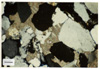
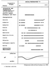 Figure 28--Paragenetic sequence of diagenetic events in Pulai-II sandstones.
Correlation of Pulai-II Formation
Reservoir Quality: Porosity, Petrography, and Diagenesis
Diagenetic Constituents and Matrix
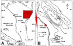
Oligocene-Miocene sandstones produce oil and gas in the southern part of the Malay basin, a Tertiary episutural, backarc basin, an upper Oligocene-lower Miocene sandstones are an important part of that producing section. This part of the basin, herein referred to as the "southern Malay basin," is located lower east coast of Peninsular Malaysia, east of Kuala Terengganu (Fig. 1). The upper Oligocene-lower Miocene sandstones, in the Pulai-II Formation, are the object of this study in an area of almost 17,000 square kilometers in the southern Malay basin.
Exploration for oil and gas in the Malay basin began in 1968 ,when Malaysia offered exploration and exploitation rights to Esso and Conoco. During the past 30+ years, more than 100,000 kilometers of seismic-line data have been acquired and processed and more than 200 exploration wells have been drilled. Most major oil discoveries have been or continuing to be developed, whereas only one gas field is currently producing.
Although hydrocarbons occur in Oligocene-Miocene sandstones, the bulk of the known oil and gas in the southern and southeastern parts of the basin is present in upper Oligocene to lower Miocene sandstones. In area of this study, the primary producing sandstones are late Oligocene-middle Miocene in age. Of the twelve fields in the study area (Figs. 1 and 2) five (Pulai, Bekok, Seligi, Kepong, and Tinggi) are producing from upper Oligocene-lower Miocene sandstones (Pulai-II and the younger lower Miocene Tapis-III formations) (Fig. 3); they produce from depths ranging from 1200 to 2200 m. The other fields produce from the Tapis-III and the middle Miocene Bekok-IVA Formation from depths of 1500 to 2000 m. A significant accumulation is present in the Pulai-II at Sotong at depths of 2000 to 2500 m, and hydrocarbons are known to be present at several fields in Seligi-IIA lower sandstones, (late Oligocene in age) that underlie the Pulai-II.
Much of the information about the southern Malay basin continues to remain in company files, but regional publications contain various data and information. In terms of tectonic setting, Parke et al. (1971) and Pupilli (1973) noted the importance of both extensional and compressive stresses in the development of the South China Sea basins, which they considered to have formed during Late Cretaceous-early Eocene. Hutchison (1973) and Hamilton (1979) considered the formation of the Gulf of Thailand, Malay, Penyu, and West Natuna basins and other basins of the South China Sea as being the results of the interaction of stresses acting on two opposite sides of the Suda microplate. Tapponier et al.(1982) suggested the alternative mechanism of extrusive tectonics.
In terms of stratigraphy of the region, Senathirajah (1969) noted the occurrences of undisturbed Jurassic-Cretaceous strata on Peninsular Malaysia, and Haile (1970, 1973) reported the occurrences of unmetamorphosed Tertiary sediments on the islands of Anambas and Natuna.
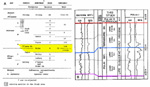
However, it remained for Armitage and Viotti (1977) to propose formally a stratigraphic scheme for the Malay basin (Fig. 3). Earlier Esso had developed an informal alphabetical nomenclature, developed on a basis of seismic sequence analysis. Carigali subsequently developed a nomenclature, utilizing Roman numerals and letters, for its lithostratigraphic subdivision of the southern part of the basin. The dominance of nonmarine sediments in the Oligocene-Miocene section has limited the biostratigraphic schemes , some of which have been noted by Ramli (1988), who also compared Esso and Carigali nomenclatures. Rashidah et al. (1988) discussed the foraminiferal schemes in the southern part of the basin and indicated their limitations due in large measure to restricted occurrences. Nik Ramli (1988) concluded that some Oligocene-Miocene sandstones in parts of the study area were deposited in fan-delta systems.
This study is based on approximately 2000 km of seismic lines, 26 wells with wireline log suites, and 350 m of core. The seismic data were used to interpret structure, stratigraphic setting, and facies in the Pulai-II Fomation (Figs. 2, 3, 4). The logs were used to identify facies, their geometry and depositional environment, generate synthetic seismograms and models, determine porosity in sandstones, and determine maximum depth of burial. The cores were used to identify facies and environment and determine diagenesis.
Malay Basin
The Malay basin trends generally northwest-southeast, and the more active part is some 500 km in length and 100 km in width (Fig. 1). Because seismic data deteriorate below 2.5 seconds two-way time, basement has not been documented. Nevertheless, Esso (1976) estimated that the total sediment thickness in the deepest parts of the basin exceeds 13,000 m. In the study area, the thickest sedimentary section is in the northwest, where it is greater than 10,000 m.
The Malay basin is an interior fracture trough (Kingston et al., 1982) or a episutural, backarc basin that formed within the relatively stable complex of the Sunda Shelf. Upper Jurassic-Upper Cretaceous strata probably constitute, at least in part, the basement of this Tertiary basin. Two of three basement wells in the study area encountered granite and the other encountered metasediments.
The southwest flank is the steeper flank, and some workers regard the basin as a half-graben. Three directions of lineaments have been mapped by Esso (1976); namely, predominantly north-south in the northern third of the basin and primarily east-west and northwest-southeast in the southern two-thirds of the basin. Esso (1976) considered these to reflect three phases of tectonism--(1) extensional phase during Late Cretaceous-late Eocene to late Miocene, characterized by rapid subsidence through block faulting, (2) compressive phase in late
Miocene-Pliocene, with formation of most of the anticlinal features, many of which are hydrocarbon-bearing, and (3) extensional reactivation of basinal development, with extensive marine deposition during Pliocene-Recent. Some of the major east-west faults in the study area (Fig. 2) are thought to be related to the initial phase of basinal development. During the second phase, at least 8 00 of sediments were eroded in some parts of the study area.
The sedimentary section of the Malay basin consists of thick sequences of interbedded sandstones and shales. Most sandstones are massive, and locally they are very thick, exceeding 100 m. The sandstones are best developed in the south and southeast parts of the basin. Four stratigraphic schemes have been developed; the nomenclature used herein combines the nomenclature of Armitage-Viotti (1977) and of Carigali (Ramli, 1988; Rashidah et al., 1988). Both utilize well logs, seismic signatures,and paleontology to recognize the widespread occurrence of shale markers and marine transgressive pulses. The age of the strata, shown in Figure 3 to range from Oligocene to Recent, is based on the work of Esso, Carigali, and Petronas. In the case of the Pulai Formation of Armitage and Viotti (1977), which is the subject of this study, it is now considered by the three groups noted above to be late Oligocene-early Miocene in age.
In this study the stratigraphic sequence containing the Pulai Formation and its lateral equivalent, Unit IIB and Unit IIA lower, is referred to as "Pulai-II Formation" (Fig. 3). It consists of the upper Terengganu Shale Formation, which consists of two shale-dominant members or parasequences, and the Pulai Sandstone, consisting of two sandstone members or parasequences.
Sandstones units within the formation are referred to as "Pulai-II sandstones."
CORRELATION OF PULAl-11 FORMATION
In the study area correlation of the Pulai-II Formation was achieved by mapping seismic sequences after seismic reflectors were correlated to wireline logs. This approach to correlation assumed that well chosen seismic reflectors follow time-lines and that a seismic sequence is a depositional sequence bounded by mappable boundaries. Determining which reflectors correspond to, or correlate with, the boundaries of the Pulai-II Formation was achieved in large measure by correlating the seismic section that extended through Ophir-1 with its logs patterns and characteristics and with a synthetic seismogran generated for it (Fig. 4). Three signatures of the synthetic seismogram of Ophir- 1 correspond, respectively, to the top, middle, and base of the Pulai-II Formation. These have been designated correspondingly as Red (R), Blue (B), and Purple (P) markers (Fig. 4). Depth conversion of the seismic markers for isopach and structural mapping was accomplished through extrapolation from an average velocity-depth curve obtained by plotting data from the checkshot well velocity surveys from six wells.
The Pulai-II Formation, a sequence of sandstones and shales, contains an occasional thin calcareous layer. They occur within thin sandstones in predominantly shale intervals, within massive sandstone bodies, and enveloping massive sandstones.
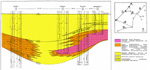
The Pulai-II Formation is best developed in the west and central parts of the study area. The Pulai Sandstone is thickest in the west with a total thickness exceeding 600 m (Fig. 5). It thins to the northeast, east, and south to less than 100 m. In the northeast it onlaps onto the basement. Sediments were derived from the northeast, east, and south during deposition of the Pulai Sandstone, whereas Terengganu Shale was derived from the northeast and southwest. The major east-west fault (Fault A in Fig. 2) marks the boundary between the relatively more stable area in the north and the less stable area in the south.
In the northeast and east the Pulai Sandstone contains thick alluvial-plain deposits, consisting of braided-channel sandstones and siltstones, along with lower coastal/delta-plain deposits (Figs. 6 and 7). They include distributary and tidal-channel sandstones, crevasse-splay, interdistributary, lagoonal, and tidal-flat sandstones, siltstones, and shales. In the southw est the sandstone bodies are generally thinner. The entire interval in this part of the area consists of lower coastal/delta-plain deposits. In part of the area, they are separated from the coarser and thicker sandstone bodies by shelfal deposits, which are shale-rich with some barrier-bar sandstones.
Detailed examination of the wireline logs indicates that four stratigraphic sequences can be distinguished within the Pulai-II Formation (Fig. 3B). From top to bottom, they are (1) Upper Terengganu Shale, corresponding to the upper half of the R-B sequence, (2) Lower Terengganu Shale (or the lower half of the R-B sequence,) (3) Upper Pulai Sandstone, the upper part of the B-P sequence, and (4) Lower Pulai Sandstone, corresponding to the lower half of the B-P sequence. The last two units, which contain the vast majority of reservoirs in Pulai-II, are the main focus of this study.
Description
This sequence consists of (a) massive, occasionally stacked, blocky sandstones with minor shale beds and lenses and (b) interbedded sandstone, siltstone, and shale with an apparent upward-coarsening log profile, commonly associated with massive sandstones also with blocky log patterns. Sandstones of the former facies are predominantly very thick and massive. There is sparse occurrence of glauconite in two wells (Duyong 6H-32.1 and Ledang-1). Associated shales are light to dark gray to tan/bluff to grayish brown and, locally, to olive green. These two main fades, recognized by log patterns, have been mapped in the study area, with the latter typifying the southern part.
The stacked, massive sandstone bodies, blocky in log character, contain an occasional thin (1 to 8 m) shale interbed. Stacked sandstone units are from 25 to 130 m thick. At Palas-1, the Lower Pulai formed on an erosional surface that scoured scoured into an upward-coarsening facies. Elsewhere, it is commonly associated with cyclically interbedded sandstones, siltstones, and shales. The stacked sandstones are fine- to very coarse-grained, well sorted, light to dark gray, and occasionally carbonaceous. They show subtle parallel laminae and medium- to large-scale cross-bedding.
In the sequence of interbedded shales, siltstones, and sandstones, individual sandstones are 1 to 10 m thick, whereas the blocky sandstone bodies are 20-25 m thick. The more massive units are generally very fine- to medium-grained, light to medium gray, carbonaceous, and calcareous in part, with traces of glauconite. Both parallel laminae and medium-scale cross-laminae are common structures. Sandstones in the interbedded sequence are very fine- to medium-grained, and gray to dark gray, with an occasional carbonaceous lamina. An individual sandstone body of this type may show patterns suggestive of upward-coarsening or upward-fining.
The map of net sand, expressed in percent (Fig. 8) shows a zone of relatively low sand content (less than 30%) in the central part of the study area. This zone, about 10-40 km wide, separates two regions of high sand content. The area to the north and northeast is relatively more sand prone (>50%) than the southern area, with 30-50% sand. An area of relative low sand percent is possibly present east of Ledang-1 and Belanga-1, where sand content is less than 40%.
The area of high sand percentage corresponds to the massive sandstone facies. On the other hand, the southern area, with lower sand percentages, is characterized by the facies of interbedded sandstone, siltstone, and shale.
The massive sandstone facies represents fluvial channel deposits, based on its blocky log pattern and core data, primarily from Pulai-1, with stacked upward-fining sandstone units. It is fairly extensive in the north and northeast, from at least the Palas-Banggol area in the north to the Pulai-Belanga area in the southeast (Figs. 6 and 7). The widespread occurrence of these sandstones suggests that they formed in braided streams in a complex alluvial system.
The system built out onto a lower coastal/delta plain in the south, based on its association with the interbedded facies. In the west the system prograded onto an lacustrine open shelf. The basis for this interpretation is the abundance of freshwater algae, along with an absence of marine faunas (Rashidah et al., 1988).
The blocky sandstones in the interbedded facies are distributary/tidal-channel deposits. The other sandstones in this facies represent tidal-flat / strand-plain / crevasse-splay sediments. For the interpretation of the latter, interbedded sandstone and shale show upward-coarsening profile, very small vertical burrows, coaly fragments and carbonaceous matter, and coastal and mangrove spores. The crevasse-splay unit shows some scouring within the sandstone section. The blocky sandstones contain rip-up clasts and glauconite. In the southern part of the study area, characterized by this interbedded facies, was an intricate channel system, through which marine waters on the east mixed with the fresh water in the west.
Description
The Upper Pulai Sandstone consists generally of very thick and massive sandstones and sandstones interbedded with mudstones and shales. The sandstone are light to dark gray, reflecting the amount of carbonaceous material. Associated shales are light to dark gray to an uncommon tan/buff to grayish brown.
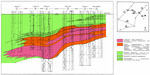
Three facies, based on log patterns, are present in the study area. One facies, occurring predominantly in the north and northeast, consists of sandstone with an occasional shale bed. The sandstones are stacked; individually they are 20 to 70 m thick. Shale beds are generally 3 to 10 m thick.
The sandstones are fine- to coarse-grained, slightly micaceous and carbonaceous or lignitic. The associated shales are medium to dark gray and occasionally brown.
The second facies is interbedded sandstone, siltstone, and shale, with some massive, blocky sandstone units. It characterizes the southern and southeastern parts of the study area. This generally upward-coarsening sequence is cyclic; the thickness of each cycle is usually 10 to 30 m. Sandstone units normally are 10 m or less in thickness. However, the massive sandstone may be 20 to 25 m thick. They are very fine- to coarse-grained, carbonaceous and lignitic in part, with rip-up clasts and traces of glauconite. The relatively thin sandstones generally show upward-fining; they occasionally contain traces of glauconite and lignitic fragments. Very small vertical burrows are common in the finer sections. Associated mudstones are medium to dark gray or occasionally tan to light brown.
Shale and siltstone, with an occasional thin sandstone bed, constitute the third facies, which occurs primarily in the west and central parts. The sandstones are generally less than 1 m thick. They are very fine-grained, carbonaceous, and slightly glauconitic. The shales are gray to dark gray and locally buff to brown.
The net sand percent map shows an area of relatively low sand content in the northwestern part of the study area, a second area of high sand content (<30%) in the northwestern part of the study area, a second area of high sand content (>50%) in the northeast, and local occurrences of 40-50% sand in the southern half of the study area that generally is characterized by 30-40% sand (Fig. 9). The northeastern sand-rich area corresponds to massive sandstone; the northwestern area, with low sand, correlates with the shale and siltstone facies; and the southern area is represented by the interbedded facies.
Estimates of environment are based on log patterns, core data, and paleontological analysis (Esso, 1978; Carigali, 1986; Rashidah et al., 1988). The massive sandstones include fluvial and estuarine channel deposits. Evidence includes the blocky log pattern, occasional fining-upward profile, cut-and-fill structures, sharp, erosional base, medium- to large-scale cross-bedding, rip-up clasts. Where burrows occur in the finer section of upward-fining sandstones, along with rip-up clasts, lignitic fragments, and glauconite, the sandstones are considered to be estuarine. They commonly occur in the southern area . The coarse-grained sandstones in the Pulai-Seligi-Tinggi area and in the areas east and northeast of Palas are probably braided-st ream deposits. The extent of the channel facies is illustrated in Figures 6 and 7. This system built out into a tidally dominated setting in the south, based on its association with the interbedded fac ies, and into the lacustrine shelf area in the west.
The interbedded sequence consists of distributary and tidal channel, and tidal-flat / strand-plain / crevasse-splay deposits. The evidence includes bioturbation, burrows, and mangrove plant spores, and glauconite, along with fining-upward profiles and cross-laminae in the blocky channelized sandstones.
The shale and siltstone, along with minor sandstone, probably formed in a delta-front/prodeltaic environment. Its setting, lithology, and glauconite are the main criteria for his interpretation.
Late Oligocene to early Miocene marked the beginning of a marine invasion that advanced into the Malay basin via a strait in the southeastern part of the study area. Glauconite occurs first in this part of the area. Pediastrum, a freshwater alga, is present in the Pulai Sandstone in Palas-1, Seligi-3, Banggol-1, Duyong Barat-1, and Angsi-1 (Esso, 1978; Carigali, 1986; Rashidah et al., 1988). Mangrove spores are present in most wells in the south.
The area in late Oligocene-early early Miocene was the site of a coastal lake or series of lakes, 150 to 300 km wide and more than 500 km long, connected to the sea by a strait, 30 to 50 km wide, in the extreme southeastern part of the study area. Three general environments were dominant:
1. Lower coastal / delta plain, with considerable tidal influence in the south and southeastern parts.
2. Alluvial plain in the north and northeast, with progradation into the other environments.
3. Nonmarine lacustrine shelf west of theTapis-Ophir area and north of Angsi during the earlier part of the period.
In early early Miocene to late early Miocene, there was marine encroachment as the strait was widened, possibly related to basinal subsidence. This corresponds to deposition of Terengganu Shale.
RESERVOIR QUALITY: POROSITY, PETROGRAPHY, AND DIAGENESIS
Porosity of the Pulai-II sandstones is based on examination of thin-sections, log analysis, and core analysis. Pore geometry and pore-modifying features and constituents were determined from XRD and SEM analyses as well as thin-section examination. Porosity greater than 25% is considered to be good to excellent; 15-25% porosity is considered to fair to good; and less than 15% is considered to be poor.
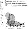
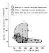
Distribution of average porosity (Fig. 10) shows two areas where porosity is better than fair to good (east and northeast, south and southwest). These two areas are separated by one of poor porosity, some 15 to 30 km wide. The area with fair to excellent porosity includes Bekok, Ledang, Seligi, Tinggi Pulai, Belumut, Belanga, and Peta. Porosity of greater than 45% is present in some sandstones at Pulai. About 10-40% of the porosity is secondary.
Porosity seemingly deteriorates abruptly to the west and south (Fig. 10). In the south this change relates to a major east-west fault, with a throw of more than 1500 m. The porosity is reduced because of both compaction and cementation. Porosity in the sandstones at Angsi, Besar, Duyong, Duyong Barat, and Sotong varies with facies and diagenesis. It ranges from 7 to 27% in thin sandstones (less than 10 m) and from 14 to 24% in thicker channelized sandstones. Porosity loss is due to compaction and quartz overgrowths and ferroan-calcite cement. Except at Sotong, most sandstones of this area are slightly overpressured, and most of these have fair to good porosity. Hydrocarbons are present in channelized sandstones at Sotong, Besar, and Duyong Barat. Where hydrocarbons are absent, porosity is usually poor, suggesting that emplacement of hydrocarbons inhibited cementation and porosity reduction.
Loss of porosity is due to increasing depth and temperature by both compaction and cementation.
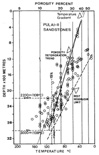
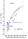
It is estimated that a porosity of 15% in the best reservoirs would be reached at a depth of approximately 3000 m (Fig. 11) with normal compaction. However, porosities of 11-13% are present in Tapis-2 at 2150-2250 m and at 2250-2450 m in Tiong-5. It is conceivable that these particular reservoirs had been buried deeper previously. In fact, data (e.g., Fig. 12) suggest that at a number of localities Pulai-II sandstones were buried deeper than their present depths. In the case of Tapis-2 (Fig. 12), where it is estimated that the section below seismic marker B was buried at least 800 m belo w its present depth, the sandstone was subjected to a temperature of 150oC (Fig. 13). Sutured quartz boundaries, present in some sandstones, probably reflect the combined effect of the increase in burial and temperature.
Authigenic quartz and ferroan calcite are the major cementing minerals. Sandstone with these diagenetic products commonly have porosities of less than 15%. These occur at burial depths greater than 2200 m, where the temperature (Fig. 11) would be in the range for vigorous precipitation of quartz and ferroan calcite, as well as continued precipitation of chlorite, pyrite, kaolinite, and smectite-illite (Surdam et al., 1989). Carbonate content is generally low in the coarser-grained sandstones (Fig. 14). The same relationships exists between clay content and porosity (Fig. 15). Where this type of sandstone shows low porosity, it probably has experienced more compaction and is cemented by quartz overgrowths and clays.
Porosity in Pulai-II sandstones is improved during diagenesis by dissolution of calcite and unstable framework grains. It is estimated that this accounts for up to 40% of the total porosity. It has been observed that the 15% porosity contour in Figure 10 corresponds generally to:
1. Present-day structural 2800-m contour line (Fig. 2).
2. Formation temperature of 140oC (Fig. 13).
3. Salinity of 1500 ppm total chloride west of Bekok-1 and Ophir-1 (Fig. 16).
Porosity enhancement was probably caused by the combined effect of acidic meteoric and connate water in the east and northeastern parts of the area and by the effect of acidic connate waters in other areas. The higher porosities in the east and northeast correspond to a structurally more tectonized area and and an area where the sandstones were truncated and subaerially exposed to erosion (and meteoric waters) during late Miocene. Sandstones in this region probably had very high initial porosities and permeabilities, providing for more rapid movement of the interstitial waters and greater chances for dissolution of the unstable constituents.
West of Bekok-1 and south of Ophir-1, where the porosity is less than 15% (Fig. 10), the facies contains considerable shale, which when compacted would have discharged a large volume of water. This water, along with that associated with the smectite-illite transformation, would have been acidic (Surdam et al., 1989), with dissolution of calcite and unstable framework grains.
However, because these areas underwent relatively rapid burial, the sediments were subjected to higher temperature regimes, and much of the enhanced porosity was lost due to compaction and subsequent cementation.
Of the 137 samples examined for composition, 88 are from the Upper Pulai Sandstone and 49 are from the Lower Pulai Sandstone. The sandstones examined are generally fine-, medium-, and coarse-grained.
The framework grains are quartz, feldspars, and rock fragments, with accessory micas and zircon. Traces of glauconite are present in some Upper Pulai Sandstone samples. Most of these are illustrated in Figures 17 and 18. The matrix and cementing materials consist primarily of carbonates, clay minerals, and quartz overgrowths, as illustrated in Figures 19, 20, 21, 22, 23, 24, 25, 26, 27. Traces of barite and pyrite (Fig. 27) are also present. Quartz composes about 50-80% of the grains; feldspars constitute 15-30%; and rock fragments represent 10-35%. Based on Folk's classification (1968), the sandstones are generally feldspathic litharenites. There is little difference in composition between the sandstones of the different facies, probably reflecting the similarity in composition of the provenance that flanked the basin (Chung, and Yin, 1968; Haile, 1970, 1973; Achalabhuthi, 1974).
The quartz grains may show somewhat open packing (part of Fig. 17), or they may be closely packed, with occasional sutured contacts (Fig. 18). Feldspar grains include plagioclase and potassium feldspar (Fig. 17) in varying proportions with the former being more common. Plagioclase is usually altered, and in some cases is completely dissolved (Fig. 17). Alteration of plagioclase resulted in the formation of albite, with kaolinite and/or illite as associated by-products
(Fig. 19). Rock fragments are predominantly poly-microcrystalline chert. Lithic fragments are generally rare. Framework chert has undergone various degrees of alteration and dissolution.
Diagenetic Constituents and Matrix
Diagenetic minerals include (1) overgrowths of quartz (Fig. 20), albite, and barite, (2) clay minerals--kaolinite, smectite-illite, illite, and chlorite (Figs. 19, 20, 21, 22, and 23), (3) carbonate minerals--calcite, ferroan calcite, siderite, and ankerite (Figs. 24, 25, and 26), and (4) pyrite (Fig. 27) and occasional iron oxide.
Clay Minerals. Clay minerals constitute 4 to 29% of the total composition. In regard to their abundance, kaolinite ranges from 10 to 90%, illite, with mixed-layer smectite-illite, 10-30%, and chlorite up to 23%. Chlorite is absent in sandstones with water saturation, Sw, of less than 35%. Chlorite characterizes sandstones adjacent to thick shale beds. There is no correlation between clay-mineral species and grain size. The more highly compacted sandstones may contain higher percentage of smectite-illite, as suggested in Tiong-5, where the porosity is 12%.
Composition of clays in the massive sandstones in the north and northeast varies from predominantly kaolinite to a mixture of kaolinite (60%), smectite-illite (17), and chlorite (23%). In the interbedded facies the average composition is 62% kaolinite, 33% smectite-illite, and 5% chlorite.
Authigenic kaolinite exhibits a high crystallinity, with crystals ranging up to several tens of micrometers. They occur as an alteration product of feldspar; as booklets or aggregates on grain surfaces filling pores and associated with authigenic quartz, and in vermicular aggregates.
Illite and smectite-illite occur as pore linings, pore fillings, and occasionally as pore-bridging material. They show several morphologies: (1) matty layers coating grains, representing detrital material or transformed smectite, (2) ragged and occasionally flake-like aggregates with altered albite, (3) whiskery aggregates, (4) thin membranes forming bridges (Fig. 22), (5) ribbon and filamentous laths also as bridges, (6) lath, blade-like clusters free in pore spaces. The different morphologies may represent variation in depth and temperature during formation.
Chlorite occurs as grain coatings (Fig. 23) , generally in sandstones in the interbedded facies. The massive sandstones that are hydrocarbon-bearing do not contain chlorite, but some water-bearing massive sandstones do contain chlorite. In the interbedded facies chlorite is present with glauconite and in hydrocarbon-bearing units.
Quartz. Quartz overgrowths line and occlude pores, form as drusy microcrystals, and occur as euhedral quartz crystals. It is commonly intergrown with kaolinite, illite, and chlorite. Grain coatings of smectite-illite and chlorite prevent overgrowths. Continued quartz overgrowth is probably related to smectite-illite transformation and dissolution of feldspar and chert.
Carbonates. Carbonates are present in most samples, representing a maximum of 25% of the total composition. Ankerite is dominant in the finer-grained sandstones, whereas siderite and ferroan calcite are common in the coarser sandstones. Calcite and ferroan calcite are not generally present in hydrocarbon-bearing, medium- to coarse-grained sandstones.
Authigenic calcite is present primarily as pore-filling and occasionally as replacive cement. It occurs in two forms--isolated patches in fine-grained sandstones, in which some of it may have quartz, and large crystals occupying the entire pore space, a relatively late product (Fig. 26) containing some iron. Siderite and ankerite occur in most sandstones. The former is present predominantly in coarser-grained sandstones, commonly as pore-filling or pore-rimming euhedral crystals (Fig. 24). Ankerite usually occurs as pore-filling clusters or aggregates in fine-grained sandstones (Fig. 25).
Other Minerals. Pyrite and barite constitute as much as 9% of the total rock. They are present together only in Seligi-3. Both occur as pore linings and pore fillings. Pyrite is present as framboids (Fig. 27), having Formed during the same time generally as authigenic quartz but before illite-mem brane precipitation. Pyrite also occurs as euhedral crystals. Barite occurs only in the massive sandstones.
Albite, as an authigenic mineral, is fairly common in most sandstone, especially in the fine- to medium-grained sandstones. It occurs as a replacement or as a by-product of albitization of plagioclase and as overgrowths. Some of the albite may be associated with smectite-illite transformation.
A simplified sequence is shown in Figure 28. It reflects observations of the occurrences and relationships of the authigenic minerals and the conditions of the pores and framework grains. Under acidic conditions both calcite cement and feldspar and lithic grains were unstable. Some ions released remained in solution (after model of Surdam et al., 1989), but others combined to form siderite, ankerite, kaolinite, quartz, smectite-illite, albite, and barite. With increasing depth of burial and temperature, chlorite, ferroan calcite, and pyrite were precipitated, in addition to the formation and precipitation of additional kaolinite, illite, and quartz overgrowths.
Sandstones compose a greater percentage of the Pulai-II Formation in the north and northeast, where greater structural activity occurred and where formation-water salinity is between 400 and 1500 ppm. These factors combine to form a favorable area for thick, porous sandstone and for development of traps. Pulai-II sandstones in the northeast occur at relatively shallow depths, and meteoric waters associated with truncation contributed to generation of secondary porosity.
Because porosity is also a function of grain size, maximum depth of burial, and fluid pressure, these factors should be carefully evaluated during exploration planning. This is especially relevant for the area south of Fault A (Fig. 2) and west of Banggol-Palas-Tiong-Bekok-Ophir (except in the extreme southwest), where the temperature is thought to have been in excess of 140oC and where porosity of most sandstones is less than 15%. Low porosity values are generally present in very fine- to fine-grained sandstones that have been buried to the greater depths; at comparable depths coarser sandstones may have good porosity, as do hydrocarbon-bearing sandstones, and overpressured sandstones.
The principal findings of this study of the upper Oligocene-lower Miocene Pulai-II sandstones in southern Malay basin are:
1. The stratigraphic section containing the Pulai-II sandstones is recognizable on seismic profiles by virtue of reflectors corresponding to the top and bottom of the Pulai-II Formation and an intervening reflector at the top of the Pulai Sandstone (and the base of the Terengganu Shale). This middle reflector corresponds to a regional unconformity that formed prior to the marine transgression associated with the Terengganu Shale.
2. Except for barrier-bar sandstones in the lower part of the Terengganu Shale, sandstones are characteristic of the interval between the lower two seismic reflectors (corresponding to the Pulai Sandstone).
3. Pulai Sandstone and Terengganu Shale, respectively, correspond to two parasequences; the sandstone and shale are separated by a sequence boundary.
4. Thickness of the interval of the Pulai-II sandstones is greatest the west (600 m); it thins to less than 100 m in the northeast, where it shows truncation, and to comparable thicknesses in the south.
5. Pulai-II sandstones, dominated by massive sandstones in the northeast and interbedded sandstones, siltstones, and shales in the south and southwest, may be divided into upper and lower units.
6. Fluvial braided-channel deposits are prominently developed in the north and northeast; coastal/deltaic-plain deposits, representing a variety of specific environments, are present in the south and southwest.
7. Porosity in the Pulai-II sandstones is governed by facies distribution, depth of burial and temperature, occurrence of hydrocarbons, and paleostructure.
8. The influence of facies is reflected not only by the distribution of sandstone bodies but also by grain-size distribution within each sandstone facies, the finer-grained sandstones generally contain greater percentages of diagenetic minerals.
9. Timely emplacement of hydrocarbons into the reservoirs in some cases has inhibited precipitation of diagenetic minerals and limited the adverse effects of compaction.
10. Faulting during late Miocene-Pliocene, particularly in the northeastern part of the southern Malay basin, resulted in exposure of Pulai-II sandstones to meteoric waters and subsequent development of secondary porosity due to dissolution of feldspars and chert.
11. The northeastern part of the southern Malay basin is expected to have the highest exploration success due to a better chance for encountering liquid hydrocarbons than in the other parts of the area. The higher temperatures in these sandstones in the south and west are likely to be reflected by the presence of gas.
Achalabuthi, C., 1974, Petroleum geology of Gulf of Thailand (abs.): AAPG Bull., v. 58, p. 1430.
Armitage, J.H., and C. Yiotti, 1977, Stratigraphic nomenclature, southern end Malay basin: Indonesian Petroleum Association, Sixth Annual Convention, Jakarta, Preprint, 43 p.
Carigali, 1986, Stratigraphic scheme for hydrocarbon exploration in Carigali's operating areas, offshore Peninsular Malaysia: unpublished company report.
Chung, S.K., and E.H. Yin, 1968, Brief outline of the geology of West Malaysia: Geological Survey of Malaysia, p. 53-67.
Esso, 1976, Structural development of the :Malay basin: unpublished contractor's report to Petronas.
Esso, 1978, Paleontological analysis of selected sidewall cores for EPMI Palas-I, Peninsular
Malaysia Contract Area: unpublished report no. EPR. 30ES.78.
Folk, R.L., 1968, Petrology of sedimentary rocks: Hemphill Publishing Company, Austin, Texas, 182 p. Haile, N. S., 1970, Notes on the geology of the Tambelan, Anambas, and Natuna islands, Sunda
Shelf, Indonesia: United Nations ECAFE-CCOP Tech. Bulletin, v. 3, p. 55-75.
Haile, N. S., 1973, The geomorphology and geology of the northern part of the Sunda Shelf and its place in the Sunda mountain system: Pacific Geology, v. 6, p. 73-90.
Hamilton, W., 1979, Tectonics of the Indonesian region: U. S. Geological Survey Professional Paper no. 1078, 345 p.
Hutchison, C.S., 1973, Tectonic evolution of Sundaland--a Phanerozoic synthesis: Geological Society of Malaysia Bull., v. 6, p. 61-86.
Kingston, D.R., C.P. Dishroon, and P.A. Williams, 1983, Global basin classification system: AAPG Bull., v. 67, p. 2175-2193.
Ngah, K., 1975, Stratigraphic and structural analyses of the Penyu basin, Malaysia: unpublished M. S. thesis,Oklahoma State University, 52 p.
Ngah, K., 1990, Deposition and diagenesis of Oligocene-lower Miocene sandstones in the southern Malay basin: unpublished Ph.D. thesis, Imperial College, University of London, 267 p.
Nik Ramli, 1988, Humid tropical fan-delta sedimentaton: an ancient model from the K sandstones (Late Oligocene-Early Miocene), southeastern part of the Malay basin, offshore West Malaysia, in Fan deltas and related systems: sedimentology and tectonic settings, W. Nemec and R.J. Steel, eds., Blackie Publication Company, p. 341-353.
Parke, M.L., K.O. Emery, R. Szymankiewiez, and L.M. Ronalds, 1971, Structural framework of the continental margin in South China Sea: AAPG Bull., v. 55, p. 723-751.
Pupilli, M., 1973, Geological evolution of South China Sea area--tentative reconstruction from borderland geology and well data: Second Indonesian Petroleum Association Convention, Jakarta, Preprint, 22 p.
Ramli, M. N., 1988, Stratigraphy and palaeofacies development of Carigali's operating areas in the Malay basin, South China Sea: Geological Society of Malaysia Bull., v. 22, p. 153-187.
Rashidah, A. K., C.K. Ho, and C.K. Razak, 1988, Biostratigraphy of selected wells from the Malay basin: Seminar, Geological Society of Malaysia, Preprint, 33p.
Senathirajah, S., 1969, Younger Mesozoic sedimentary rocks, State of Johore, West Malaysia: AAPG Bull, v. 53, p. 2187-2194.
Surdam, R.C., L.J. Crossev, E.S. Hagen, and H.P. Heasler, 1989, Organic-inorganic interactions and sandstone diagenesis: AAPG Bull., v. 73, p. 1-23.
Tapponnier, P., G. Peltzer, A.Y. LeDain, R. Amijo, and P. Cobbold, 1982, Propagating extrusion tectonics in Asia--new insights from simple experiments with plasticine: Geology, v. 10, p. 611-616.