![]() Click to view article in PDF format.
Click to view article in PDF format.
by
Marc B. Edwards1
Search and Discovery Article #40063 (2002)
*Adapted for online presentation from article of the same title by the same author at the GCAGS 52nd Annual Convention, Austin, Texas, October 30-November 1, 2002. Appreciation is expressed both to the author and to GCAGS.
1Marc B. Edwards Consulting Geologists, Inc., Houston, Texas (www.marcedwards.com; [email protected])
Until the advent of sequence stratigraphy (late 1980s), geologists commonly subdivided the siliciclastic units of the Gulf Coast Basin into regressive and transgressive components. Sequence stratigraphy divided the regressive component into two separate units: the highstand systems tract (HST) and the lowstand systems tract (LST).
According to sequence stratigraphic theory, the HST and the LST are separated by a sequence boundary, with two implications: (1) the LST of a particular sequence is younger than the HST of the preceding sequence, and (2) the two systems tracts contain facies that are not genetically related. In the years following the introduction of sequence stratigraphy (early 199Os), it was noted in several publications that in areas where sediment input was active during a period of overall sea level fall, a single widespread sequence boundary did not form. Since the model necessitated the existence of a sequence houndary, stratigraphers argued over where the sequence boundary should he placed. To try to deal with this problem, the concept of “forced regression” was introduced, hut this did not resolve the fundamental problems.
Uncritical application of the original (eustatically forced) sequence-stratigraphic paradigm requires geoscientists to identify stratigraphic components without any basis in fact or theory. Where analysis of the data indicates that updip and downdip facies are genetically related, a sequence model may he inappropriate or misleading. In these cases, the term regressive systems tract is preferred, as it removes the need to identify a conceptual artifact: the chronostratigraphically and geometrically significant sequence boundary.
|
uLate Pleistocene shelf to shelf margin uSequence stratigraphy of Late Pleistocene uLate Pleistocene shelf margin to slope uTertiary depositional systems
uLate Pleistocene shelf to shelf margin uSequence stratigraphy of Late Pleistocene uLate Pleistocene shelf margin to slope uTertiary depositional systems
uLate Pleistocene shelf to shelf margin uSequence stratigraphy of Late Pleistocene uLate Pleistocene shelf margin to slope uTertiary depositional systems
uLate Pleistocene shelf to shelf margin uSequence stratigraphy of Late Pleistocene uLate Pleistocene shelf margin to slope uTertiary depositional systems
uLate Pleistocene shelf to shelf margin uSequence stratigraphy of Late Pleistocene uLate Pleistocene shelf margin to slope uTertiary depositional systems
uLate Pleistocene shelf to shelf margin uSequence stratigraphy of Late Pleistocene uLate Pleistocene shelf margin to slope uTertiary depositional systems
uLate Pleistocene shelf to shelf margin uSequence stratigraphy of Late Pleistocene uLate Pleistocene shelf margin to slope uTertiary depositional systems
uLate Pleistocene shelf to shelf margin uSequence stratigraphy of Late Pleistocene uLate Pleistocene shelf margin to slope uTertiary depositional systems
uLate Pleistocene shelf to shelf margin uSequence stratigraphy of Late Pleistocene uLate Pleistocene shelf margin to slope uTertiary depositional systems
uLate Pleistocene shelf to shelf margin uSequence stratigraphy of Late Pleistocene uLate Pleistocene shelf margin to slope uTertiary depositional systems
uLate Pleistocene shelf to shelf margin uSequence stratigraphy of Late Pleistocene uLate Pleistocene shelf margin to slope uTertiary depositional systems
uLate Pleistocene shelf to shelf margin uSequence stratigraphy of Late Pleistocene uLate Pleistocene shelf margin to slope uTertiary depositional systems
uLate Pleistocene shelf to shelf margin uSequence stratigraphy of Late Pleistocene uLate Pleistocene shelf margin to slope uTertiary depositional systems
uLate Pleistocene shelf to shelf margin uSequence stratigraphy of Late Pleistocene uLate Pleistocene shelf margin to slope uTertiary depositional systems
uLate Pleistocene shelf to shelf margin uSequence stratigraphy of Late Pleistocene uLate Pleistocene shelf margin to slope uTertiary depositional systems
|
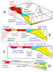
Thumbnails with Abbreviated Captions
Click here for sequence of the phases of progradation and minibasin initiation.
Building paleogeographic maps (which represent, by implication, a time interval) requires the ability to delimit, both vertically and laterally, a corresponding rock-stratigraphic interval. Sequence stratigraphy provides principles for recognizing time-significant stratigraphic surfaces, thereby improving stratigraphic prediction. However, observations on Cenozoic Gulf Coast strata appear to contradict some aspects of the sequence stratigraphic model. Dip sections through Gulf Coast Tertiary units typically show blocky and upward-fining sand-dominated units updip, that are replaced gradually downdip by upward-coarsening shale to sand units (e.g., Van Wagoner et al., 1990 Figure 33). If we accept the sequence-stratigraphic premise that all strata below a sequence boundary are older than all strata above that sequence boundary, and if a sequence boundary is placed at the base of the blocky sand units (as in the above referenced cross section), then there can be no overlap in time between shelf to shelf-margin deltaic progradation and updip channelized erosion and deposition. According to sequence stratigraphy, a paleogeographic map that combined different systems tracts would be misleading or wrong. Another property of a sequence boundary that is unsatisfactory in a Gulf Coast context is the manner in which it separates highstand regressive deposits from lowstand regressive deposits (e.g., Vail et al., 1977, Figures 8a and 9; Van Wagoner et al., 1988, Figure 2; Posamentier and Vail, 1988, Figure 23). This problem was discussed at length by Morton and Suter (1996), discussed below. In this case, the sequence-stratigraphic model divides a continuous regressive package of sediment into two components. The main purpose of this paper is to argue that the above assumptions do not apply to regressive sequences formed in a high-sediment-supply regime where sediment is delivered to the shoreline during sea level fall. This argument applies as well to revised sequence-stratigraphic models (the “forced regression” described by Posamentier et al., 1992; Hunt and Tucker, 1992; Kolla et al., 1995; Hunt and Tucker, 1995; Kolla et al., 2000) which replaced the single sequence boundary with a family of sequence boundaries of the next highest order (shorter duration). One of the most confusing aspects of sequence stratigraphy is the multiple use of the key terms. Thus a rock unit can be variably interpreted as: (1) having been deposited during a particular time interval, (2) having been deposited during a particular phase of the sea level cycle, or (3) having been deposited in a particular paleogeographic location. Without additional clarification by the user, confusion can result. I view the sequence-stratigraphic model as unambiguously including both chronostratigraphic and sea level connotations: “Sequence stratigraphy is the study of genetically related facies within a framework of chronostratigraphically significant surfaces” (Van Wagoner et al., 1990, p. l), and “. .Vail proposed eustasy as the predominant driving mechanism for sequence evolution (Vail et al., 1977)” (Van Wagoner et al., 1990, p. 2). This paper argues that fundamental tenets of the sequence-stratigraphic model violate a significant body of observations on Pleistocene and older depositional units in the Gulf of Mexico Basin. Stratigraphers require a termi nology that allows: (1) the designation of paleogeographic position without reference to a sea-level-driven origin, and (2) the description of key stratigraphic surfaces without chronostratigraphic implications.
Late Pleistocene Depositional Systems-Shelf to Shelf Margin Late Pleistocene depositional systems are a useful starting point for improving reconstructions of depositional and stratigraphic aspects of older systems. Several deltas along the northern Gulf Coast Basin shelf margin provide insights into key features and unresolved issues. Of particular note are studies of the late Pleistocene Mississippi deltas (Morton and Suter, 1996) and the late Pleistocene (Mobile River) Lagniappe delta (Kindinger, 1988; Sydow et al., 1992; Sydow and Roberts, 1994; Winn et al., 1998; Kolla et al., 2000). Another key area of progress has been the issue of how and when sediment is transported to the slope and basin floor. Recent studies have aimed at linking sands in slope minibasins to their updip sources (e.g., Winker and Booth, 2000, Beaubouef and Friedman, 2000). The first comprehensive regional database and interpretation of the Pleistocene of the northern Gulf of Mexico is the landmark work of Berryhill et al. (1986). Numerous seismic lines in this atlas illustrate not only the incised fluvial systems on the shelf, but the widespread distribution of packages of basinward dipping clinoforms that strongly indicated that delta sediments were deposited (and preserved) while sea level fell to the shelf margin during Pleistocene glacial periods. This would counter the sequence-stratigraphic notion that a sea level fall would result in abrupt shift of deposition from the shelf to the lower slope or basin floor. Subsequently, following numerous studies, Winn et al. (1998, p. 593) wrote about the Lagniappe delta: “The clinoform zones represent shelf-edge deltas that are inferred to have been deposited during falling sea level. This origin generally confirms models of Fisk (1944), Frazier (1974), Suter and Berryhill (1985), Berryhill et al. (1986) and Winn et al. (1995), who recognized the importance of delta deposition during falling sea level.” Studies of the late Pleistocene Mississippi deltas by Morton and Suter (1996) were conducted to compare the development of these deltas to the predictions of the sequence-stratigraphic model. These authors reached several conclusions that are pertinent here. Their first key conclusion was that the “strata1 patterns are continuous from shelf phase to shelf-margin phase of fluvial deltaic deposition” (Morton and Suter, 1996, p. 526). In other words, between updip deltas on the shelf, deposited during eustatic highstand, and the most downdip deltas at the shelf margin deposited during the eustatic lowstand, there was no prominent break that would represent the sequence boundary separating the highstand and lowstand systems tracts. The authors depicted the progressive progradation of the deltas, the emergence of the adjacent shelf, the action of fluvial courses and localized fluvial incision during sea level fall (Figure 1; their Figure 4). The second key conclusion of Morton and Suter (1996) concerned the comparative properties of the highstand and lowstand deltas: “Strata1 patterns and lithologic relationships clearly demonstrate that potential reservoir facies of lowstand shelf-margin deltas include distributary mouth bars, channel fills, and reworked shoreline and shelf sands that are not constrained by an incised valley or former shelf margin and are comparable in stratigraphic position and paleogeographic location to sand bodies of the highstand systems tract model” (Morton and Suter, 1996, p. 529). Thus highstand and lowstand deltas can only be distinguished by their context with external phenomena, not by their internal properties. The third key conclusion reached by Morton and Suter (1996) involves the placement of the lower boundary of the depositional sequence. They stated: “At the depositional lowstand shoreline fluvial systems no longer incise, but act as distributaries delivering sediment to the lowstand delta. Here, the base of channel erosion is a diastem that does not have regional chronostratigraphic significance and if chosen as the sequence boundary, it has the unfortu nate consequence of separating portions of the same deltaic succession into different sequences” (Morton and Suter, 1996, p. 509). The authors recognized genetic continuity from the base of the incised fluvial channel updip, downstream through the distributary channel and its attached and genetically associated mouth bars, continuing along the prodelta, and terminating tangentially by downlap in the condensed section at the top of the underlying sequence. This boundary is thus, according to the authors, the correlative conformity to the sequence boundary represented by the base of the incised fluvial valley updip. Unfortunately, this contention is the sequence-stratigraphic Gordian knot, which is discussed in more detail below.
Sequence Stratigraphy of Late Pleistocene Depositional Systems--Shelf to Shelf Margin The discussion by Morton and Suter (1996) on the issues surrounding the choice of surface to serve as a sequence boundary is only one of numerous viewpoints on this topic. Figure lA, modified from Morton and Suter (1996, their Figure 4D) shows the key features and surfaces of a shelf-margin delta. Note the updip sequence boundary at the base of the fluvially incised valley. As an erosion surface, this surface terminates downdip in the erosional base of the distributary channels. Note that the downdip portion of the sequence boundary, as defined by Morton and Suter (1996) exists as a correlative conformity, in particular the zone composed of the downlap surface of the prodelta clinoforms and the condensed section represented by the prodelta clinoform toes. A problem arises when the correlative-conformity downlap surface is traced updip to an area where the overlying section contains an incised fluvial channel (Figure 1). A sequence-stratigraphic interpretation constructed by the Morton and Suter (1996) rules would show ambiguity where incised valleys overlie the intact downlap surface: the sequence boundary could be either surface (but probably not both). A related problem is presented by the designation of the emergent coastal plain as the top of the depositional sequence. According to sequence stratigraphic practice, the emergent coastal plain is part of the sequence boundary that separates the highstand systems tract of the previous sequence from the lowstand systems tract of the ensuing sequence. For the purpose of placing genetically related sediments in the same stratigraphic unit, it would seem desirable to retain the lower boundary along the correlative conformity, except where this is removed locally by valley incision. But this essentially places the sequence boundary along (or very close to) the flooding surface, which is clearly not in accord with sequence stratigraphic practice. I conclude that in areas of continuous sediment supply during a sea level fall, there is no geologically coherent way to designate a sequence boundary (a single surface that is chronostratigraphically significant) that separates updip from downdip deposits (Figure 1C). The above considerations do not apply in areas where sedimentation was shut off for a significant portion of the time during a sea level fall. These relationships can be illustrated in a strike section through a deltaic depocenter and a flank area, updip of the shelf margin (Figure 1D). This shows how the sandy deltaic package that is deposited during the sea level fall changes facies to marine mud overlain by the subaerial exposure surface. Farther along strike, this mud may be locally eroded by a true incised valley that was bypassing sediment across the exposed shelf. The absence of deltaic deposits fringing the incised valley suggests that the valley formed by headward gully extension on the emergent shelf, until an updip drainage was captured. Two diagrams are included to contrast the stratigraphic architecture and chronostratigraphic interpretation of late Pleistocene deltas described above according to the sequence-stratigraphic model (Figure 2) and the modified Morton and Suter (1996) model (Figure 3). The latter figure was based upon regional studies of Tertiary strata, described below. In the sequence-stratigraphic model, there is a moment of time when the entire sequence boundary existed as a physical surface. In contrast, in the regressive-systems-tract model, the deltaic package cannot be subdivided into non-genetically related parts by a unique surface that existed over the region at one moment of time. An alternative sequence-stratigraphic approach places a higher order sequence boundary between each successive downstepping event (Mitchum and Van Wagoner, 1991; Posamentier et al., 1992; Kolla et al., 2000), so that a fourth order cycle would be subdivided by fifth order sequence boundaries and their correlative conformities.
Late Pleistocene Depositional Systems-Shelf Margin to Slope Just as the sequence boundary serves as a crucial boundary between the highstand and lowstand systems tracts on the shelf to shelf margin, this surface also extends down the slope into the basin. Within the sequence-stratigraphic paradigm, the transport of coarse sediment into deep water occurs along the basinal segment of the sequence boundary (e.g. Van Wagoner et al., 1990). Recent studies of sediment-gravity-flow systems of the northern Gulf of Mexico Basin suggest that large submarine fans become increasingly rare going back through time, particularly prior to the Pleistocene (Pulham, 1993; Prather et al., 1998; Winker and Booth, 2000). Detailed studies of the late Pleistocene depositional systems along the shelf margin and slope describe minibasin sediment-gravity-flow fills that appear to have been emplaced without the aid of large, mappable submarine canyons (Winker and Booth, 2000). In general terms, Beaubouef and Friedman (2000) agree: “The southern limit of the Texas-Louisiana Shelf is rimmed by thick shelf margin deltas interpreted to have formed during the last Wisconsin glacial event These fluvio-deltaic systems provided the source for large volumes of sediment transported to the deep basin” (p. 41). However, referring to the minibasins in front of the Trinity-Brazos shelf margin delta, they stated “. the presence of an older, buried canyon beneath the deltas can not be precluded, as that region of the subsurface is not imaged by the high-resolution seismic data” (p. 52). These authors emphasized the uncertainties that remain: “although the source of sediment delivered to these basins is well known, the exact mechanisms of sediment gravity flow initiation and transport to the slope is not known” (p. 52). On the other hand, Morton and Suter (1996) emphasized that “. . . no incised valleys or submarine canyons breach the paleoshelf margin, even though incised drainages were present updip.. .” (p. 505), apparently implying that sediment gravity flows originated on shelf-margin-delta clinoforms (as shown in their Figure 4), and then continued downslope into minibasins. The late Pleistocene Mississippi canyon that strongly eroded a narrow corridor of the shelf and shelf margin did not form until after the Mississippi deltas had reached the shelf margin (Coleman et al., 1983). Additional work is required to resolve the important issues raised by Beaubouef and Friedman (2000), as cited above. The large-scale relationships between stratigraphy and structure in the Gulf of Mexico basin, where the depositional substrate is highly mobile salt and shale, are well established (Diegel et al., 1995). Prodigious stratigraphic thickening in the region of the shelf margin and upper slope is associated with regional extension associated with the displacement of salt, and in some cases, the downdip gliding of thick sediment layers (Figure 4). The outer shelf, shelf margin, and upper slope area can be defined in terms of two fundamental and complementary regimes that define the stratigraphic relationships around the important interface between shallow water (topset, or shelf) and deep water (foreset, slope) settings (Figure 4). The first regime is characterized by shelf-margin progradation associated with complex systems of growth faults (Winker and Edwards, 1983). Individual fourth-order regressive cycles expand by up to ten times across individual faults. The second regime is shelf-margin retrogradation caused by large-scale collapse that removes thousands of feet of section, truncating deeper structures, and tilling with a complex of slide blocks and gravity flows, capped with deltas (Morton, 1993; Edwards, 2000). Collapse events affect wide areas of the shelf margin along strike, unlike submarine canyons that excavate narrow dip-oriented erosional features. Retrogradational shelf-margin collapse is related to high rates of sediment supply, rapid progradation of the shelf margin and progradation over a buried shelf margin (see Ross et al., 1994). There is no clear evidence that these features form as a direct response to relative sea level fall, although there is abundant evidence for high-frequency sea-level falls manifested by incised valleys and other phenomena (e.g. Edwards, 1990, 1994). An important issue, but beyond the scope of this paper, concerns the relative importance and character of the delivery of sands to the slope via shelf-margin deltas (progradational) versus shelf-margin erosional features (retrogradational). In seismic data, the diagnostic features of the retrogradational collapse are the basal collapse discontinuity, which truncates updip strata, and the internal till, which commonly has an internal clinoform signature. The features are similar in appearance, respectively, to the sequence boundary and lowstand prograding wedge unit of the sequence stratigraphic model (e.g. Edwards, 1990, 1991), although in plan view the collapse is strike continuous rather than dip elongate, as pointed out above. The collapse events usually truncate several regressive cycles, and the fill contains one to several regressive cycles. Therefore, the alternating pulses of progradation and retrogradation would be considered third order according to sequence-stratigraphic terminology (e.g. Mitchum and Van Wagoner, 1990). The relative importance of regional drainage switching, climate, eustasy, and hinterland tectonics in influencing third-order cycles still does not appear to be well understood in the Paleogene. In the Gulf Coast Basin individual regressive pulses are stratigraphic events that are commonly referred to as fourth-order sequences (e.g. Mitchum and Van Wagoner, 1990). Several papers presented under the “sequence stratigraphy” theme have discussed these cycles in the Gulf Coast Basin. A key paper that included the upper Wilcox of South Texas (Mitchum and VanWagoner, 1991) did not recognize the existence of growth faults along a cross section (their Figure 17) that traverses the well-documented upper Wilcox trend (e.g. Edwards, 1981). Unquestionably, the complex structural history of all but the youngest deposits greatly complicates the application of sequence stratigraphy to this basin margin. Nevertheless, a number of regional stratigraphic studies conducted on the Gulf Coast Basin provide a basis for delineating several key features of depositional cycles or sequences in the region (e.g. Edwards, 1980, 1990, 1991, 1994; Galloway et al., 1982; Van Wagoner et al., 1990; Xue and Galloway, 1995). Unfortunately, relatively few of the published studies combine sufficient detail (correlation and mapping to at least “fourth-order” cycles), adequately dense well control (to encounter incised valleys and channels), and regional scope extending across an entire depocenter and flank system (or even a significant portion of a depocenter or flank). Marine flooding surfaces and their associated transgressive shales and “highstand” condensed sections are the best, and often only, regional markers for correlating depositional cycles (e.g. Van Wagoner et al.; 1990, their Figs. 22 and 33). The cycles formed in a range of waveto river-dominated coastal plains and shorelines, often in relation to well-defined depocenters and depoflanks (Fisher and McGowen, 1967; Galloway, 1989a, b; Edwards, 199 1; Morton et al., 1988, 1991). Depending on facies, cycles can be traced along dip for tens of miles. The downdip extensions of these cycles are either truncated by collapse erosional events or thickened dramatically by growth faulting. Cycle expansion is commonly associated with specific, predictable facies changes (Edwards, 1995a). Farther downdip, correlation usually breaks down in the slope environment. Regional studies illustrate examples of the distribution of lithofacies, depositional environments, and stratigraphic architecture for the various units mentioned above. These include the river-dominated depocenter and depoflank of the Yegua (Edwards, 1990, 1991), the wave-dominated interdeltaic bight of the Frio (Edwards, 1986; Galloway and Morton, 1989), growth-faulted river-dominated, wave-influenced Wilcox deltas (Edwards, 198 l), and the river-dominated lower Miocene (Edwards, 1994). A key element of depocenter versus depoflank setting is the rate of sediment supply. In a depocenter the sediment supply “hose” is on most of the time; small relative changes in sea level move the hose around, but do not shut it off. In contrast, in the depoflank, the hose is on only a small part of the time, and genetically unrelated sediment bodies may become juxtaposed. Another contrast is the subsidence rate, which in the depocenter has an average rate that may be several times that of the depoflank. The relationship between third- and fourth-order events is shown in a dip stratigraphic cross section in the lower Miocene of southwest Louisiana (Figure 5). This section connects 20 wells and is based on the integrated analysis of almost 2,000 wells in a 1,500-mi2 area (Edwards, 1994). In this section, the higher resolution stratigraphy is provided by flooding surfaces. Two shelf-margin collapse events are identified, of which the larger earlier one represents a third-order event, as does the group of regressive cycles that occur in this part of the lower Miocene. Sediment gravity flows locally overlie the collapse unconformities. I will selectively cite the literature in order to make several points within the scope of this paper. These concern the distribution and properties of channel-form features, and the delivery of sand to the shelf margin. Typically, sequence stratigraphy recognizes channel-form features to be either distributary channels or incised valleys (e.g. Van Wagoner et al., 1966, their Figure 26). This model of extremes led to an interpretation of the middle Miocene sandstones as having been either lowstand incised valleys or highstand shelf and mouth bar sands (Van Wagoner et al., 1988, their Figure 33). In a study of the lower Miocene (Edwards, 1994), I displayed a series of maps of selected channel-form systems to illustrate the variations shown both in terms of external geometry and relation to adjacent facies. The conclusion reached, that erosion surfaces within a regressive cycle were possibly formed at different times, is consistent with the model proposed by Morton and Suter (1996; see discussion above). The observed wide variety of channel-form geometries (Edwards, 1994) is not consistent with the sequence-stratigraphic model of channel versus valley. Although the study of the lower Miocene mapped and analyzed the section using fourth-order stratigraphic features, another example that may be more compelling is a regional study of the middle Eocene Yegua and Cook Mountain Formations that spans the entire depocenter and flanks (Edwards, 1990, 1991). This study was based on about 4,500 well logs and detailed fourth-order cycle mapping. A regional map of generalized paleoenvironments (Figure 6), based on net-sandstone and log-facies maps (Edwards, 1990,1991) illustrates several important features that are only apparent in large regional maps of tine-scale stratigraphy. The depocenter is characterized by an area of amalgamated and coalesced mouth-bar sands along the shelf margin, with mappable associated channels. Thus, many of the channels are surrounded by mouth bars. Some of the channels, however, appear to be associated with downdip shelf-margin deltas, without adjacent mouth-bar deposits (bays of Figure 6). In contrast, in the depocenter flanks, channels can be mapped across the shelf and are associated with downdip shelf-margin deltas. In several cases channels cannot be mapped across the entire shelf but only inferred from limited updip well control. The occurrence of shelf-margin deltas in the same depositional cycle is consistent with sand bypass across the shelf. These relationships are similar in many regards to the late Pleistocene shelf and shelf margin deltas described earlier in this paper. At times, science goes to great lengths to adapt new data to existing explanations. Past examples include complex solar system models designed to remain geocentric, and the original grouping of the Burgess Shale invertebrate fauna in existing phyla (Gould, 1989). How important are the underlying premises if the whole paradigm shifts as refinements are introduced? Is an underlying principle effectively buried by subsequent developments, or does it remain a permanent, integral property of the paradigm? For example, the astronomical system based on the positioning of the Earth at the center of the Solar system had to eventually be swapped out, in its entirety, for a Solar-centric system (although lessons learned about various orbital geometries could be retained for use in different systems). What does sequence stratigraphy become if, in time, it is acknowledged that flooding (or abandonment) surfaces, not unconformities, are more reliable, chronostratigraphically significant surfaces; if depositional systems reorganize more during highstand than lowstand; if falling sea-level depositional systems are not partitioned by a sequence boundary? Processed-based models, accompanied by descriptive terminology, will encourage geoscientists to be open to solving problems with a healthy, multiple-working hypothesis approach.
During relative sea-level fall, a high-sediment-supply delta will deposit a single coherent, integrated deposit that can be considered a regressive systems tract. There is no surface comparable to the sequence boundary of the sequence-stratigraphic model that separates this delta into updip highstand and downdip lowstand systems tracts. In order to honor the genetic integrity of the delta deposit, cycle boundaries should be placed at flooding surfaces. Reorganization of depocenters is more likely to occur across flooding surfaces rather than between flooding surfaces. Subsurface maps of regressive cycles bounded by flooding surfaces will clearly show the positions of incised valleys, using either net sand or log facies data, in the depoflank areas, due to their contrast with adjacent facies. In the depocenters, the discrimination of incised valleys from distributary channels is often either not possible, or not desirable, for sound theoretical reasons. It is possible that some degree of “forcing,” or sea-level fall, accompanied many Gulf Coast Tertiary high-frequency (“4th order”) cycles. In this case, “valley” features, difficult to identify in depocenters, would be important targets for exploration in depoflanks, where their detection would require time-scale stratigraphic analysis applied on a regional scale.
I would like to acknowledge Tucker Hentz’s careful review of the manuscript. Numerous oil and gas companies have supported the regional studies that underlie many of the observations made and conclusions reached in this paper. I appreciate the encouragement and support they have given to me. Beaubouef, R. T., and S. J. Friedman, 2000, High resolution seismic/sequence stratigraphic framework for the evolution of Pleistocene intra slope basins, in P. Weimer, R. M. Slatt et al., eds., Western Gulf of Mexico: Depositional models and reservoir analogs, Gulf Coast Section-SEPM Twentieth Research Conference, Deep-Water Reservoirs of the World, p. 40-60. Berryhill, H. L., Jr., J. R. Suter, and N. S. Hardin, 1986, Late Quaternary facies and structure, northern Gulf of Mexico: American Association Petroleum Geologists Studies in Geology, 23, 289 p.
Coleman, J. M., D. B. Prior, and J. F. Lindsay, 1983,
Deltaic Influences of shelf edge instability processes, in D.J. Stanley
and G Moore, eds., The Shelf Break: Critical Interface on Continental
Margins: SEPM Special Publication 33, p. 121-137. Edwards, M. B., 1980, The Live Oak delta complex, an unstable shelf-edge delta in the deep Wilcox trend of South Texas. Gulf Coast Association of Geological Societies Transactions v. 30, p. 71-79. Edwards, M. B., 1981, Upper Wilcox Rosita Delta System of South Texas: growth faulted shelf edge deltas: American Association Petroleum Geologists Bulletin v.65, p. 54-73. Edwards, M. B., 1986, Sedimentary effects of differential subsidence in Frio shoreface-shelf sediments, Gulf Coast Tertiary: Houston Geological Society Bulletin v. 29, nr. 3, p. 10-14. Edwards, M. B., 1990, Stratigraphic analysis and reservoir prediction in the Eocene Yegua and Cook Mountain Formations of Texas and Louisiana. Sequence Stratigraphy as an Exploration Tool: Gulf Coast Section SEPM, Eleventh Ammal Research. Conference, p. 15 l-l 64. Edwards , M. B., 1991, Control of depositional environments eustacy, and gravity and salt tectonics on sandstone distribution in an unstable shelf edge delta, Eocene Yegua formation, Texas and Louisiana: Gulf Coast Association of Geological Societies Transactions, v. 41, p. 237-252. Edwards, M. B., 1994, Enhancing sandstone reservoir prediction by mapping erosion surfaces, Lower Miocene deltas, southwest Louisiana, Gulf Coast Basin: Gulf Coast Association of Geological Societies Transactions, v. 44, p. 205-215. Edwards, M. B., 1995a, Differential subsidence and preservation potential of shallow water Tertiary sequences, northern Gulf Coast Basin, U.S.A., in A. G. Plint, ed., Sedimentary Facies Analysis: A Tribute to the Research and Teaching of Harold G. Reading. International Association of Sedimentologists Special Publication 22, p. 285-281. Edwards, M. B., 1995b, A Journeyman’s Approach to Sequence Stratigraphy: Lafayette Geological Society, Lafayette, Louisiana, 11 p. Edwards, M. B., 2000, Origin and significance of retrograde failed shelf margins; Tertiary northern Gulf Coast Basin: Gulf Coast Association of Geological Societies Transactions, v. 50, p. 81-93. Fisher, W. L., and J. H. McGowen, 1967, Depositional systems in the Wilcox Group of Texas and their relationship to occurrence of oil and gas: Gulf Coast Association of Geological Societies Transactions, v. 27, p.105-125. Fisk, H. N., 1944, Geological investigation of the alluvial valley of the lower Mississippi River: Vicksburg, Mississippi, U.S. Army, Corps of Engineers, Mississippi River Commission, 78 p. Frazier, D. E., 1974, Depositional episodes-their relationship to the Quaternary stratigraphic framework in the northwestern portion of the Gulf Basin: The University of Texas at Austin, Bureau of Economic Geology Circular No. 74-1,28 p. Galloway, W. E. 1989a, Genetic stratigraphic sequences in basin analysis I: architecture and genesis of flooding-surface bounded depositional units: American Association Petroleum Geologists Bulletin v.73, p.125-142. Galloway, W. E. 1989b, Genetic stratigraphic sequences in basin analysis II: application to northwest Gulf of Mexico Cenozoic basin: American Association Petroleum Geologists Bulletin v.73, p. 143-154. Galloway, W. E. and R. A. Morton, 1989, Geometry, genesis, and reservoir characteristics of shelf sandstone facies , Frio Formation (Oligocene), Texas coastal plain, Gulf Coast Section SEPM Seventh Ammal Research Conference, p. 89-115. Galloway, W. E., D. K. Hobday, and K. Magara 1982, Frio Formation of the Texas Gulf Coast Basin: Depositional Systems, Structural Framework, and Hydrocarbon Origin, Migration, Distribution, and Exploration Potential: The University of Texas at Austin, Bureau of Economic Geology Report of Investigation No. 122,78 p. Gould, S. J.,1989, Wonderful Life. W. W. Norton and Co. NY. 347 p. Hunt, D., and M. E. Tucker, 1992, Stranded parasequences and the forced regressive wedge systems tract: deposition during base-level fall: Sedimentary Geology, v. 81, p. l-9. Hunt, D., and M. E. Tucker, 1995, Stranded parasequences and the forced regressive wedge systems tract: deposition during base-level fall-reply: Sedimentary Geology, v. 95, p. 147-160. Kindinger, J. L., 1988, Seismic stratigraphy of the Mississippi-Alabama shelf and upper continental slope: Marine Geology, v. 83, p. 79-94. Kolla, V., P. Biondi, B. Long, R. and Fillon, 2000, Sequence stratigraphy and architecture of the late Pleistocene Lagniappe delta complex, northeast Gulf of Mexico, in D. Hunt and R. L. Gawthorpe, eds., Sedimentary Responses to Forced Regressions, Geological Society London Special Publication 172, p. 291-327. Kolla, F., H. W. Posamentier, and H. Eichenseer, 1995, Stranded parasequences and the forced regressive wedge systems tract: deposition during base-level fall-discussion: Sedimentary Geology, v.95, p. 139-145. Mitchum, R. M., and J. C. Van Wagoner, 1990, High-frequency sequences and eustatic cycles in the Gulf of Mexico Basin: Gulf of Mexico: Sequence Stratigraphy as an Exploration Tool: Gulf Coast Section SEPM, Eleventh Ammal Research Conference, p. 257-267. Mitchum, R. M., Jr., and J. C. Van Wagoner, 1991, High-frequency sequences and their stacking patterns: sequence-stratigraphic evidence of high-frequency eustatic cycles: Sedimentary Geology, v. 70, p. 131-160. Morton, R. A.,1993, Attributes and origins of ancient submarine slides and filled embayments: examples from the Gulf Coast Basin: American Association Petroleum Geologists Bulletin, v. 77, p. 1064-1081. Morton, R. A., L. A. Jirik, and W. E. Galloway, 1988, Middle-Upper Miocene Depositional Sequences of the Texas Coastal Plain and Continental Shelf: Geologic Framework, Sedimentary Facies, and Hydrocarbon Plays: The University of Texas at Austin, Bureau of Economic Geology Report of Investigation 174, 40 p. Morton, R. A., R. H. Sams, and L. A. Jirik, 1991, Plio-Pleistocene Depositional Sequences of the Southeastern Texas Continental Shelf and Slope: Geologic Framework, Sedimentary Facies, and Hydrocarbon Distribution: The University of Texas at Austin, Bureau of Economic Geology Report of Investigation 200, 80 p. Morton, R.A., and J. R. Suter, 1996, Sequence stratigraphy and composition of late Quaternary shelf-margin deltas, northern Gulf of Mexico: American Association Petroleum Geologists Bulletin, v. 80, p. 505-530. Posamentier, H. W., and P R. Vail, 1988, Eustatic controls on elastic deposition II-sequence and systems tract models, in C. K. Wilgus et al. eds., Sea-level changes: an integrated approach: Society of Economic Paleontologists and Mineralogists Special Publication 42, p. 109-124. Posamentier, H. W., G. P. Allen, D. P. James, M. Tesson, 1992, Forced regressions in a sequence stratigraphic framework: concepts, examples, and exploration significance: American Association Petroleum Geologists Bulletin, v. 76, p. 1687-1709. Prather, B. E., J. R. Booth, G. S. Steffens, and P. A. Craig, 1998, Classification, lithologic calibration, and stratigraphic succession of seismic facies of intraslope basins, deep-water Gulf of Mexico: American Association Petroleum Geologists Bulletin, v. 82, p. 701-728. Pulham, A. J., 1993, Variations in slope deposition, Pliocene-Pleistocene, offshore Louisiana, northeast Gulf of Mexico: American Association Petroleum Geologists Memoir 58, p. 1999233. Ross, W. C., B. A. Halliwell, J. A. May, D. E. Watts and J. P. M. Syvitski, 1994, Slope readjustment: a new model for the development of submarine fans and aprons: Geology, v. 22, p. 5 1 l-5 14. Suter, J. R., and H. L. Berryhill, Jr., 1985, Late Quaternary shelf-margin deltas, northwest Gulf of Mexico: American Association Petroleum Geologists Bulletin, v. 69, p. 77-91. Sydow, J., and H. H. Roberts, 1994, Stratigraphic framework of a late Pleistocene shelf-edge delta, northeast Gulf of Mexico: American Association Petroleum Geologists Bulletin, v. 78, p. 1276-1312. Sydow, J., H. H. Roberts, A.H. Bouma, and R. D. Wlnn, 1992, Constructional subcomponents of a shelf-edge delta, northeast Gulf of Mexico: Gulf Coast Association of Geological Societies Transactions, v. 42, p. 717-726. Van Wagoner, J. C., H. W. Posamentier, R. M. Mitchum, P. R. Vail, J. F. Sarg, T. S. Loutit, and J. Hardenbol, 1988, An overview of sequence stratigraphy and key defmitions, in C. K. Wilgus et al., Sea-level changes: an integrated approach: Society of Economic Paleontologists and Mineralogists Special Publication 42, p. 39-45. Van Wagoner, J. C., R. M. Mitchum, K. M. Campion, and V D. Rahmanian, 1990, Siliciclastic sequence stratigraphy in well logs, cores, and outcrops: concepts of high-resolution correlation of time and facies: American Association Petroleum Geologists Methods in Exploration 7, 55p. Vail, P. R., R. M. Mitchum, and S. Thompson, 1977, Seismic stratigraphy and global changes of sea level, part 3: relative changes of sea level from coastal onlap, in C. W. Payton, ed., Seismic stratigraphy applications to hydrocarbon exploration: American Association Petroleum Geologists Memoir 36, p. 129-144. Winker, C. D., and J. R. Booth, 2000, Sedimentary dynamics of the salt-dominated continental slope, in P. Weimer, R. M. Slatt et al., eds., Deep-Water Reservoirs of the World, Gulf Coast Section SEPM Twentieth Research Conference, p. 1059-1086. Winker, C.D. and Edwards 1983: Unstable progradational elastic shelf margins, in D.J. Stanley and G. Moore, eds., The Shelf Break: Critical Interface on Continental Margins, SEPM Special Publication 33, p.139-157. Winn, R. D., Jr., H. H. Roberts, B. Kohl, R. H. Fillon, A.H. Bouma, and R.E. Constans, 1995, Latest Quaternary deposition on the outer shelf, northern Gulf of Mexico: Facies and sequence stratigraphy from Main Pass Block 303 shallow core: Geological Society of America Bulletin, v. 107, p. 851-866. Winn, R. D., Jr., H. H. Roberts, B. Kohl, R. H. Fillon, J. A. Crux, A.H. Bouma, and H. W. Spero, 1998, Upper Quaternary strata of the upper continental slope, northeast Gulf of Mexico: Sequence stratigraphic model for a terrigenous shelf edge: Journal of Sedimentary Research, v. 68, n. 4, p. 579-595. Xue, Liangqing, and William E. Galloway, 1995, High-Resolution Depositional Framework of the Paleocene Middle Wilcox Strata, Texas Coastal Plain: American Association Petroleum Geologists Bulletin, 79, p. 205-230. |
 Figure
1. Depositional elements and significant surfaces in a shelf to shelf
margin setting characterized by high sediment input and falling sea
level.
Figure
1. Depositional elements and significant surfaces in a shelf to shelf
margin setting characterized by high sediment input and falling sea
level. Figure
2. Strata1 patterns and chronostratigraphy according to the standard
Exxon sequence-stratigraphic model.
Figure
2. Strata1 patterns and chronostratigraphy according to the standard
Exxon sequence-stratigraphic model. Figure
4. Schematic cartoon to illustrate the large-scale (third-order) phases
of shelf-margin progradation and slope-minibasin initiation, alternating
with phases of shelf-margin retrogradation.
Figure
4. Schematic cartoon to illustrate the large-scale (third-order) phases
of shelf-margin progradation and slope-minibasin initiation, alternating
with phases of shelf-margin retrogradation.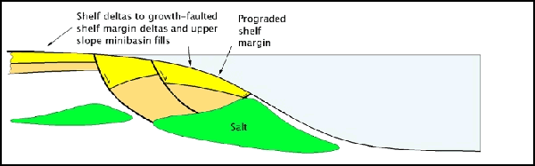