 Click to view posters in PDF format.
Poster 1 Poster 2 Poster 3
PSInfluence of Basin Dynamics on Upper Devonian Black Shale Deposition, Western New York State and Northwest Pennsylvania*
By
Gary G. Lash1
Search and Discovery Article #30050 (2007)
Posted April 22, 2007
*Adapted from poster presentation, AAPG Annual Convention, Long Beach, California, April 1-4, 2007
1Dept. of Geosciences, SUNY Fredonia, Fredonia, NY 14063, USA ([email protected])
Black shale is ubiquitous to the Upper Devonian succession of the Appalachian Basin of western New York and northwest Pennsylvania. The spatial distribution of the organic-rich deposits appears to have been partly controlled by Acadian basin dynamics. Middle Devonian tectonic quiescence reflected by the Tully Limestone was terminated by development of an Acadian forebulge. The resulting Taghanic unconformity achieved its maximum hiatal extent in Chautauqua and Cattaraugus counties, New York, extending south into Pennsylvania. Uplift may have been controlled by basin structures, including the Clarendon-Linden Fault (CLF), which lies close to the eastern zero-thickness line of the Tully Limestone. Subsidence of the forebulge is marked by onlap of the Upper Devonian Geneseo black shale onto the eroded Tully Limestone and underlying Middle Devonian shale. However, the fact that the Geneseo is not present in extreme western New York and northwest Pennsylvania suggests that the forebulge had migrated to the west. The forebulge was no longer a positive area in New York when the uniformly south- and west-thinning Middlesex black shale accumulated. However, the CLF appears to have accommodated down - to - east offset during deposition of the Rhinestreet black shale resulting in abrupt eastward thinning of the radioactive facies proximal to the CLF. Subsidence to the east of the CLF, perhaps a consequence of further migration of the Acadian thrust complex, ponded the more clastic facies of the Rhinestreet in this area of the basin; the organic-rich deposits accumulated in the more elevated region west of the fault. The Upper Devonian Dunkirk black shale attains a maximum thickness in northwest Pennsylvania reflecting subsidence of the forebulge perhaps induced by advance of the Acadian thrust terrane.
|
uSkaneateles-Tichenor interval uMiddlesex-Rhinestreet interval
uSkaneateles-Tichenor interval uMiddlesex-Rhinestreet interval
uSkaneateles-Tichenor interval uMiddlesex-Rhinestreet interval
uSkaneateles-Tichenor interval uMiddlesex-Rhinestreet interval
uSkaneateles-Tichenor interval uMiddlesex-Rhinestreet interval
uSkaneateles-Tichenor interval uMiddlesex-Rhinestreet interval
uSkaneateles-Tichenor interval uMiddlesex-Rhinestreet interval
uSkaneateles-Tichenor interval uMiddlesex-Rhinestreet interval
uSkaneateles-Tichenor interval uMiddlesex-Rhinestreet interval
|
(Figures 1-1 – 1-3) Ettensohn (1985, 1994) has demonstrated that major stratigraphic patterns of Middle and Upper Devonian black shale units, specifically their westward transgression over time, can be described in terms of four tectophases, each one defined by four stages, including (1) the inception of tectonism and consequent rapid subsidence of a peripheral basin and consequent accumulation of black shale; (2) impending collision and associated regression and accumulation of gray shale and siltstone; (3) collision accompanied by widespread uplift and development of regional disconformities; and (4) tectonic quiescence and widespread accumulation of limestone in slowly transgressing seas. However, local basin dynamics (i.e., development of forebulges inheretid from earlier events) appear to have played an important role in the accumulation of Middle and Upper Devonian black shale in the western New York, northwest Pennsylvania, and eastern Ohio region of the Appalachian Basin.
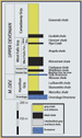
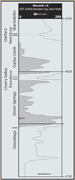
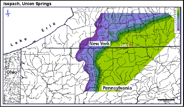
Marcellus Shale - Stafford Limestone Interval (Figures 1-4 – 2-7) The transition from the Onondaga Limestone to the Union Springs Shale marks the start of Ettensohn’s (1985) second tectophase as the stable platform started to subside as a consequence of thrust loading in the hinterland. The local disappearance of units of the Onondaga Limestone suggests that the contact is erosional (e.g., Rickard, 1984). The Union Springs black shale onlaps the eroded surface to the WNW. However, appears to have further eroded the Onondaga to the west. A brief period of stabilization, perhaps partly as a consequence of a eustatic rise in sea level, is marked by accumulation of the Cherry Valley Limestone, which overlies the Onondaga Limestone in the absence of the Union Springs Shale. The widespread accumulation of the Oatka Creek Shale over much of the Appalachian Basin reflects regional, rapid subsidence of the basin at the onset of Ettensohn’s (1985) second tectophase (Hamilton-Smith, 1993). However, variations in the thickness of the Oatka Creek Shale suggest a somewhat more complex behavior. Unlike an other Devonian shale units in this region of the Appalachian Basin, the Oatka Creek Shale thicknens gradually to the west from a NNE-SSW axis trending through Wyoming, Cattaraugus, and Chautauqua counties New York, into Warren and McKean counties, Pennsylvania. The Oatka Creek Shale thickens more rapidly to the east of this line. Accumulation of the Stafford Limestone marks another period of tectonic quiescence and relatively clear water. The Stafford is thickest a bit to the west of the area of minimum thickness of the Oatka Creek Shale suggesting that this region of the basin was elevated. The thinning and eventual loss of the Stafford to the west and east probably reflects a transition into deeper water and passage into more shaley (deeper) facies.
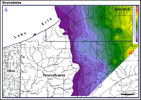
Skaneateles Shale - Centerfield Limestone - Ludlowville Shale - Tichenor Limestone Interval (Figures 2-8 – 2-13)
The change from the Stafford Limestone to the Skaneateles Shale reflects the tectonic reactivation of the basin. The bottom part of the Skaneatele in the eastern portion of the study area is composed of black shale that can be difficult to differentiate from the underlying Oatka Creek Shale. These deposits, the Levanna Shale, tell of rapid subsidence and onlap to the west as the organic-rich deposits gave way to organic-lean gray shale. The Centerfield Limestone marks a brief period of tectonic stabilization and relatively clear water. However, basin subsidence and further progradation of clastic deposits is marked by accumulation of the Ludlowville Shale, which further onlapped the Oatka Creek Shale where the Stafford Limestone is absent. This event was not accompanied by deposition of organic-rich shale. An interlude in tectonic activity is marked by deposition of the Tichenor Limestone.
Moscow Shale - Tully Limestone Interval (Figure 2-14 - 2-19) The abrupt change from the Tichenor Limestone to the Moscow Shale reflects subsidence of the basin and onlap of the Moscow Shale to the northwest. However, the isopach pattern of the Moscow Shale, specifically the saddle in the depositional strike in Cattaraugus County, NY, south into northern McKean County, PA, suggests that as much as 100 feet of the Moscow Shale was eroded in this area of the basin. Cross-sections (Figures 2-16, 2-19) reveal that the Tully Limestone locally rests on the Tichenor Limestone, the intervening Moscow Shale having been completely eroded in these areas (northern and western Chautauqua County, NY). Accumulation of the Tully Limestone over the eroded Moscow Shale marks the end of Ettensohn’s (1985) second tectophase (Figure 2-16). Carbonate sediment was deposited under conditions of tectonic inactivity following uplift of the Moscow Shale and slow transgression in clastic-deficient water (Ettensohn, 1985). However, tectonic quiescence was terminated by localized uplift and erosion of the Tully Limestone, especially along a north-south-trending axis coincident with that region of greatest erosion of the Moscow Shale. There has been a good amount of confusion regarding the Tully Limestone in the subsurface of western NY and northwest PA. Indeed, some have confused the Tully with the Tichenor Limestone, especially where the Tully rests unconformably on the Tichenor. Wright (1973), for example, followed this convention maintaining that the Tully Limestone is not present in the subsurface of Chautauqua County, NY, and northwest PA. This interpretation was accepted by de Witt et al. (1993). However, Rickard (1989) offered the dissenting view that the Tully can be recognized in western NY, an interpretation fully supported by the present study (e.g., Figure 2-19). The problem as recounted by Rickard (1989) was that Wright (1973) and many drillers (as revealed by review of drilling records) confused the Tully Limestone with the Tichenor Limestone and vice versa.
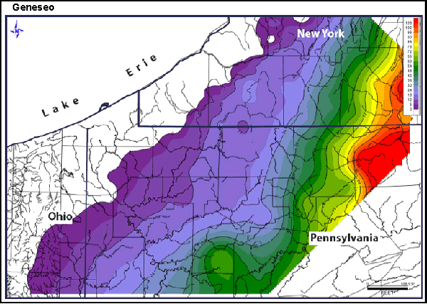
Geneseo - Penn Yan - West River Shale Interval (Figures 3-1 – 3-4) Deposition of the Geneseo Shale reflects rapid subsidence to a depth of perhaps 200 m (Ettensohn, 1985) induced by crustal loading in response to Acadian plate convergence in tandem with major global transgression (Dennison and Head, 1975). The organic-rich deposits, which mark the start of Ettensohn’s (1985) third tectophase, onlapped the eroded Tully Limestone and Moscow Shale (the Tagahanic unconformity; Johnson, 1970) extending over the topographically positive area responsible for erosion of the Moscow Shale and, subsequently, the Tully Limestone. The Geneseo was onlapped by the Penn Yan - West River Shale interval, which appears to have entered the basin from the southeast as the rate of subsidence diminshed. These units can be differentiated in the field, the Penn Yan comprising laminated dark gray shale and the West River being dominated by gray organic-lean shale. However, no attempt was made to make this distinction in the subsurface. Still, correlation of thin calcareous intervals in the Penn Yan - West River succession demonstrate onlapping of these deposits over the Geneseo Shale and older strata.
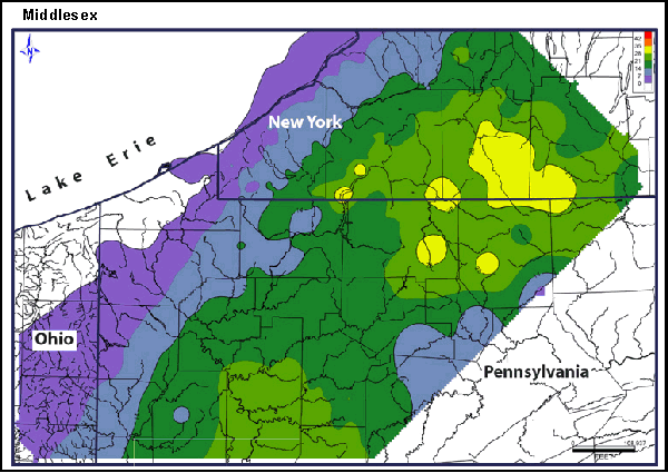
Middlesex Shale - Cashaqua Shale - Rhinestreet Shale Interval (Figures 3-5 – 3-7) The Middlesex Shale accumulated over the West River Shale extending farther to the northwest than the Geneseo black shale. TheMiddlesex organic-rich shale reflects renewed tectonic activity in the Acadian thrust belt and/or a eustatic rise in sea level (T-R Cycle IIc; Johnson et al., 1985). The topographic welt that resulted in erosion of the Tully Limestone had subsided by Middlesex time leaving no imprint on these and subsequent deposits.
The record of Acadian thrust tectonics in the Middle Devonian clastic succession of the Appalachian Basin begins with the Marcellus black shale, specifically the Union Springs and Oatka Creek shales. The former records initial subsidence of the basin following accumulation of the Onondaga Limestone during a period of tectonic quiescence at the end of tectophase one (Ettensohn, 1985; Ver Straeten and Brett, 2000). The organic-rich deposits may have onlapped a forebulge generated by the same tectonic activity that had initiated subsidence. Accumulation of the Oatka Creek Shale and equivalents from New York well into Ohio and Pennsylvania tells of widespread subsidence during tectophase two. However, deposition of the Oatka Creek Shale appears to have been coeval with development of a positive element or welt in western New York that reduced accommodation space thereby favoring only a thin Oatka Creek sequence here. The inferred position of the Oatka Creek topographic high west of the final position of the Onondaga forebulge suggests that the onset of tectophase twowas accompanied by westward migration of the forebulge and basin axis. Accumulation of the balance of the Hamilton Group records further forward migration of the basin axis punctuated by periods of tectonic stability and deposition of carbonate. The basin underwent uplift and erosion at the end of Hamilton time resulting in the removal of ~ 100 feet or more of the Moscow Shale, locally cutting into the underlying Tichenor Limestone. A lull in tectonic activity and a eustatic rise in sea level is marked by deposition of the Tully Limestone over the eroded Moscow Shale on what may have been a broad forebulge. This brief interlude of tectonic inactivity was terminated by uplift and erosion of the Tully Limestone. The “two-sided” nature of truncation of the Tully in western New York extending into Pennsylvania demonstrates the local nature of maximum Tully erosion (e.g., Brett et al., 1990) placing it a bit to the east of the locus of maximum pre-Tully erosion of the Moscow Shale. This may reflect a small amount of retrograde movement of the welt that occurred during the brief period of thrust relaxation recorded by the Tully Limestone. Renewed tectonc activity in the Acadian thrust belt (third tectophase) and consequent rapid subsidence of the basin in tandem with a eustatic rise in sea level, resulted in deposition of the Geneseo black shale. The subsequent Middlesex and Rhinestreet black shales reflect further westward migration of the basin axis unaffected by those positive elements that had shaped the stratigraphic architecture of the Middle and Upper Devonian succession of western New York and northwest Pennsylvania.
Brett, C.E., Goodman, W.M., and LoDuca, S.T., 1990, Sequences, cycles, and basin dynamica in the Silurian of the Appalachian Foreland Basin: Sedimentary Geology, v. 69, p. 191-244. de Witt, W., Jr., and Colton, G.W., 1978, Physical stratigraphy of the Genesee Formation (Devonian) in western and central New York: U.S. Geological Survey Professional Paper 1032-A, p. A1-A22. Dennison, J.M., and Head, J.W., 1975, Sea-level variations interpreted from the Appalachian Basin Silurian and Devonian: American Journal of Science, v. 275, p. 1089-1120. Ettensohn, F.R., 1985, The Catskill Delta Complex and the Acadian Orogeny: A model, in Woodrow, D.L., and Sevon, W.D., eds., The Catskill Delta: GSA Special Paper 201, p. 39-49. Ettensohn, F.R., 1994, Tectonic controls on formation and cyclicity of major Appalachian unconformities and associated stratigraphic sequences: SEPM Concepts in Sedimentology and Paleontology #4, Tectonic and Eustatic Controls on Sedimentary Cycles, p. 217-242. Hamilton-Smith, T., 1993, Stratigraphic effects of the Acadian orogeny in the authochthonous Appalachian basin, in Roy, D.C., and Skehan, J.W., eds., The Acadian orogeny: recent studies in New England, Maritime Canada, and the autochthonous foreland: GSA Special Paper 275, p. 153-164. Johnson, J. G., 1970, Taghanic onlap and the end of North American provinciality: GSA Bulletin, v. 81, p. 2077-2106. Johnson, J. G., G. Klapper, and C. A. Sandberg, 1985, Devonian eustatic fluctuations in Euramerica: GSA Bulletin, v. 96, p. 567-587. Rickard, L.V., 1984, Correlation of the subsurface Lower and Middle Devonian of the Lake Erie region: GSA Bulletin, v. 95, p. 814-828. Rickard, L.V., 1989, Stratification of the subsurface low and mid-Devonian of New York, Pennsylvania, Ohio, and Ontario: New York State Museum and Science Map and Chart Series 39, 59 p. Ver Straeten, C.A., and Brett, C.E., 2000, Bulge migration and pinnacle reef development, Devonian Appalachian Foreland Basin: Journal of Geology, vol. 108, p. 339-352. Wright, N.A., 1973, Subsurface Tully Limestone New York and northern Pennsylvania: New York State Museum and Science Service, Map and Chart Series Number 14, 15 p.
|


