|
uAbstract
uFigure
captions
uAcknowledgment
uReferences
uAbstract
uFigure
captions
uAcknowledgment
uReferences
uAbstract
uFigure
captions
uAcknowledgment
uReferences
uAbstract
uFigure
captions
uAcknowledgment
uReferences
uAbstract
uFigure
captions
uAcknowledgment
uReferences
uAbstract
uFigure
captions
uAcknowledgment
uReferences
uAbstract
uFigure
captions
uAcknowledgment
uReferences
uAbstract
uFigure
captions
uAcknowledgment
uReferences
|
Figures
|
 |
Figure 1. Placid Oil Company WXC-State 1
well. Southwest view of Penrod rig 20 on location in central
Utah. The Canyon Mountains are in distance where Neoproterozoic
strata are thrusted over Cambrian through Devonian strata.
Photograph by Doug Sprinkel, winter 1978. |
|
 |
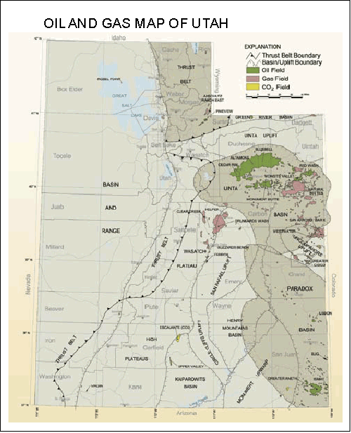
Figure 2. Oil and gas map of Utah. Oil
and gas fields in Utah showing geologic provinces, sedimentary
basins, and principal structural boundaries (modified from
Chidsey et al., 2005). |
|
 |
Figure 3. Northern Utah thrust belt
analog. Central thrust belt Utah play in the late 1970s was
pursued based on the success in the northern Utah sector of the
Sevier thrust belt. |
|
 |
Figure 4. Utah thrust belt and newly
discovered Covenant field. Oil and gas map showing leading edge
of Sevier thrust belt and location of the Covenant field.
Click to view in sequence Figures 2,
3, and 4 (oil and gas fields and Utah thrust belt). |
|
 |
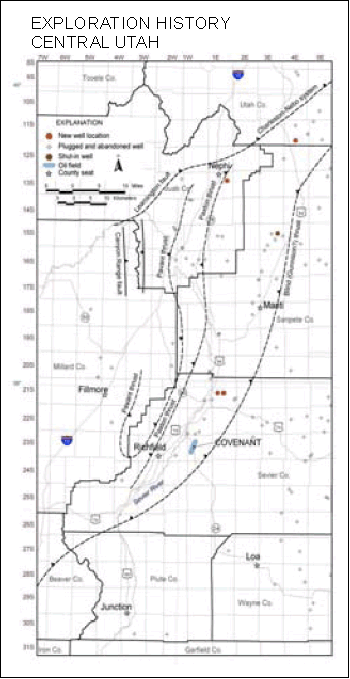
Figure 5. Exploration history of central
Utah (thrust fault locations modified from Willis, 1999).
The map area represents about 276 square townships. The map area
has had fewer than 120 wells drilled since 1918, which means one
well has been drilled per every two townships or one well per
about 72 square miles. The increase in drilling in the 1970s and
early 1980s was due to significant increase in oil prices from
the Arab oil embargo, the discovery of the Pineview field in
northern Utah, and the Iranian revolution. |
|
 |
Figure 6. Key shows. Several wells had
shows that may be key to future exploration. These wells
highlight the potential targets in the Twin Creek Limestone,
Navajo Sandstone, Sinbad Limestone (Moenkopi Formation), and
Permian section. See Figures 7,
8, 10, and
11.
Click to view in sequence Figures 5
and 6 (exploration history and key shows). |
|
 |
Figure 7. Placid WXC-State 1. The
WXC-State 1 well penetrated a repeated Twin Creek and Arapien
section with gas shows in the hanging wall (HW) section of
Arapien and footwall section of Twin Creek and Navajo. Three
cores were taken from the Navajo in which oil stain along
fractures were noted. Swab test in the Navajo yielded a small
flare of gas. The Twin Creek was not swabbed. The dipmeter
analysis suggested this well was on the west flank of the
structure. Data are from mud log and personal notes of Doug
Sprinkel. |
|
 |
Figure 8. Placid WXC-Howard 1A. The
WXC-Howard 1A well had no apparent thrusted sections, and had
multiple gas and oil shows in the Twin Creek. No oil or gas
shows were visible in the Navajo but trip gas was abundant and
increased on subsequent trips. Swab tests through casing in
multiple zones of the Twin Creek and Navajo yielded some gas.
Data are from mud log and personal notes of Doug Sprinkel. |
|
 |
Figure 9. Reason to drill WXC-Howard 2.
The WXC-Howard 2 well was drilled to evaluate shows tested and
described in the WXC-Howard 1A well in an up-dip position. A
similar argument led American Quasar to Pineview discovery in
1975. |
|
 |
Figure 10. Placid WXC-Howard 2. This well gained structural
elevation and had shows in several of the key reservoirs of the
Twin Creek Limestone and Navajo Sandstone. The Navajo was tested
with a gas flare that was snuffed out by a strong fresh-water
flow. The Twin Creek was not tested. Data are from mud log and
personal notes of Doug Sprinkel. |
|
 |
Figure 11. Other notable wells. The
Placid WXC-Barton 1, Williams Exploration Monroe Fee 1, and
Phillips Petroleum US-E 1 are other wells with key shows in
reservoirs older than the Jurassic Navajo Sandstone, most
commonly in the Triassic Sinbad Limestone Member of the Moenkopi
Formation. The Barton well is also noted for being the only well
in central Utah to contain deadly concentrations of hydrogen
sulfide gas and very high down-hole temperatures. Data are from
mud log and personal notes of Doug Sprinkel. |
|
 |
Figure 12. Conclusions from drilling.
-
Structural
geometries similar to northern Utah thrust belt
-
Jurassic Twin
Creek and Navajo reservoirs
-
No marine
Cretaceous source rocks in subthrust position
-
What was
source of oil and gas shows?
As the result of Placid’s drilling
program and wells drilled by other operators, we could not
demonstrate marine Cretaceous source rocks in a subthrust
position. Placid began investigating other possible source rocks
in Mississippian, Permian, and Jurassic strata. |
|
 |
Figure 13. Stratigraphic chart of
central Utah thrust belt. Stratigraphic correlation chart
showing potential source and reservoir rocks of each
stratigraphic region. |
|
 |
Figure 14. Covenant oil analysis.
Collecting oil from the Covenant field and the gas chromatograph
(GC) analysis of oil (Baseline DGSI, 2005). |
|
 |
Figure 15. Basic oil characteristics.
Basic geochemical characteristics of the oil from the Covenant
field. Production is from the Navajo Sandstone but the source of
the oil is Mississippian. |
|
 |
Figure 16. Saturated vs. aromatic
hydrocarbons. C13 aromatic versus saturated
hydrocarbons plot shows the oil from the Covenant field is
geochemically different from the well-known Phosphoria source of
Rangely field, Colorado, the Cretaceous source of fields in
northeastern Utah, and the mixed Cretaceous-Phosphoria source of
Ashley Valley field in eastern Utah. The age of the oil is
likely Mississippian. |
|
 |
Figure 17. Potential Mississippian
source rocks for central Utah. The possible source rocks for the
Covenant field is likely one of the three Mississippian
formations given above. |
|
 |
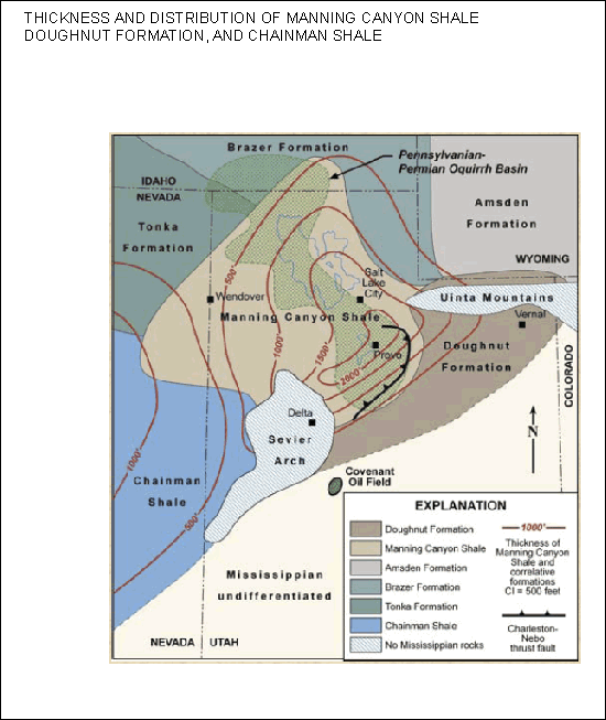
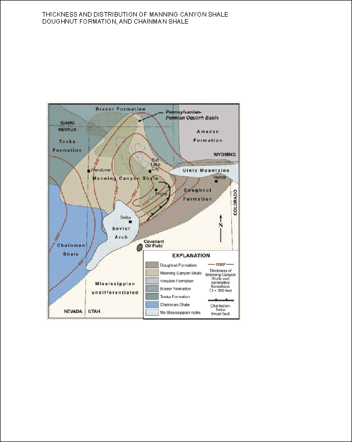
Figure 18. Thickness and distribution
of Manning Canyon Shale, Doughnut Formation, and Chainman Shale
(modified from Moyle, 1958). The Doughnut Shale is the principal
source rock for this time slice; however, the Manning Canyon
Shale could be a significant source rock if it is preserved in a
subthrust position along the edge of the Oquirrh Basin where
much thinner Oquirrh Formation would have been deposited. |
|
 |
Figure 19. Distribution of Delle
Phosphatic Member (modified from Sandberg and Gutschick, 1984).
Delle Phosphatic Member of the Deseret Limestone could be the
dominant source rock during this time slice. The Delle on the
hanging wall of the Nebo thrust would likely be “over cooked”
but should be in an optimum thermal regime in the central area.
Note that the Chainman Shale is restricted to western Utah and
eastern Nevada, and is not likely a viable source for the
Mississippian oil in central Utah.
Click to view in sequence Figures 18
and 19 (distribution of Manning Canyon Shale and Delle
Phosphatic Member). |
|
 |
Figure 20. Reservoir - Navajo
Sandstone. The Navajo Sandstone is the main reservoir for the
Covenant field. The Navajo is dominantly a quartz sandstone, but
the reservoir is likely heterogeneous with varying porosities
and fine-grained baffles (Figure 22)
that could affect
production. Detailed reservoir characterization studies are
needed to understand better the reservoir characteristics. |
|
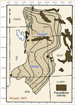 |
Figure 21. Navajo/Nugget Sandstone
thickness map (Picard, 1975). Isopach map of the Navajo/Nugget
Sandstone. Arrows indicate paleowind directions.
Click to view in sequence Figures 18,
19, and 21 (distribution of potential source rocks and
reservoir). |
|
 |
Figure 22. Interdune oasis deposit,
Killpecker Dunes, Wyoming (Ahlbrandt and Fryberger, 1981).
Interdune oasis and wadi deposits are potential baffles to
production within the Navajo Sandstone. |
|
 |
Figure 23. Arapien Shale exposed in
Salina Canyon. The principal seal is likely the Jurassic Arapien
Shale as oil migrated along thrust faults. |
|
 |
Figure 24. Sevier thrust belt
(modified from Witkind, 1982). Structural history of the central
Utah thrust belt. The key items include thrusting that was
sequential and began in Late Jurassic to late Early Cretaceous.
Thrusting ended in Eocene and was likely coincident with
Laramide deformation. Neogene extension is also a part of the
structural history. |
|
 |
Figure 25. Central Utah thrust belt
play area. Exploration summary of central Utah play.
Click to view in sequence Figures 5,
6, 20, and 25 (exploration history, key shows, reservoir—Navajo
Sandstone, and play area). |
|
 |
Figure 26. Idealized cross section,
showing the structural style of traps and relation to source
rocks and seals. |
|
 |
Figure 27. Source of oil and
hydrocarbons shows is key! Key to central Utah is understanding
the location and maturation of the source rocks. That
information combined with timing and migration pathways will
lead to additional discoveries. |
|
 |
Figure 28. UGS source-rock assessment.
The Utah Geological Survey (UGS) source-rock assessment will
sample surface exposures and collect cuttings from wells in the
UGS Core Research Center for geochemical biomarker analysis. |
|
 |
Figure 29. UGS outcrop analog studies.
The Utah Geological Survey is planning to conduct detail
reservoir characterization studies of the Navajo Sandstone. |
Return to top.
Funded in part by U.S. Department of
Energy's Preferred Upstream Management Program (PUMPII), National
Petroleum Technology Office, Tulsa, Oklahoma, Contract No.
DE-FC26-02NT15133.
Ahlbrandt, T.S., and Fryberger,
S.G., 1981, Introduction to eolian deposits, in Scholle, P.A.,
and Speraring, D., eds., Sandstone depositional environments: AAPG
Memoir 31, p. 11-47.
Baseline DGSI, 2005, Basic
crude oil characteristics and biomarker analysis from the Kings Meadow
Ranches no. 17-1 well, covenant field, Sevier County, Utah: Utah
Geological Survey Open-File Report 467, 15 p.
Chidsey, T.C., Jr., Wakefield,
Sharon, Hill, B.G., and Hebertson, Michael, 2005, Oil and gas fields map
of Utah: Utah Geological Survey Map 203DM, scale 1:500,000.
Moyle, R.W., 1958,
Paleoecology of the Manning Canyon Shale in central Utah: Brigham Young
University Research Studies, v. 5, no. 7, 86 p., 7 plates.
Picard, M.D, 1975, Facies,
petrography and petroleum potential of Nugget Sandstone (Jurassic),
southwestern Wyoming and northeastern Utah, in Bolyard, D.W.,
ed., Symposium on deep drilling frontiers of the central Rocky
Mountains: Rocky Mountain Association of Geologists Guidebook, p.
109-127.
Poole, F.G., and Claypool, G.E.,
1984, Petroleum source-rock potential and crude-oil correlation in the
Great Basin, in Woodward, J., Meissner, F.F., and Clayton, J.L.,
eds., Hydrocarbon source rocks of the greater Rocky Mountain region:
Rocky Mountain Association of Geologists, p. 179-230.
Sandberg, C.A., and Gutschick,
R.C., 1984, Distribution, microfauna, source-rock potential of
Mississippian Delle Phosphatic Member of Woodman Formation and
equivalents, Utah, in Woodward, J., Meissner, F.F., and Clayton,
J.L., eds., Hydrocarbon source rocks of the greater Rocky Mountain
region: Rocky Mountain Association of Geologists Guidebook, p. 135-178.
Swetland, P.J., Clayton, J.L.,
and Sable, E.G., 1978, Petroleum source-bed potential of
Mississippian-Pennsylvanian rocks in parts of Montana, Idaho, Utah, and
Colorado: The Mountain Geologist, v. 14, p. 79-87.
Witkind, I.J., 1982, Salt
diapirism in central Utah, in Nielson, D.L., editor, Overthrust
belt of Utah: Utah Geological Association Publication 10, p. 13-30.
Villien, A., and Kligfield,
R.M., 1986, Thrusting and synorogenic sedimentation in central Utah,
in Peterson, J.A., ed., Paleotectonics and sedimentation in the
Rocky Mountain region: AAPG Memoir 41, p. 281-306.
Willis, G.C., 1999, The Utah thrust system – an overview, in
Spangler, L.W., ed., Geology of northern Utah and vicinity, Utah
Geological Association Publication 27, p. 1-9.
Return to top.
|