PSAnalysis of Low Permeability Intervals in a Heavy-Oil Braided Stream Deposit Using a Combination of Core and Log Analysis, Kern River field, California
By
Larry C. Knauer1, Robert Horton2, and Allen Britton3
Search and Discovery Article #50004 (2003)
*Adapted for online presentation from poster session presented at the AAPG Convention, Salt Lake City, Utah, May, 2003.
1ChevronTexaco, Bakersfield, CA ([email protected])
2California State University, Bakersfield, CA
3Core Laboratories, Bakersfield, CA
Editorial Note: This article, which is highly graphic (or visual) in design, is presented as: (1) three posters, each represented by a PDF image, which contains the usual enlargement capabilities; and (2) searchable HTML text with figure captions linked to corresponding illustrations with descriptions.
Users without high-speed internet access to this article may experience significant delay in downloading some of the PDF files due to their sizes.
Click on individual poster below, to view it in PDF format.
|
|
The
Kern River field is located in Kern County, California, immediately adjacent to
the city of Bakersfield (Figure 1). This super-giant
oil field has produced over 1.5 billion barrels of 12-degree-API gravity crude
during the last 103 years from a Mio-Pleistocene braided stream deposit (the
Kern River alluvial fan) (Figures 2,
3, and 4). Estimated
reserves are still substantial. Production of over 100,000 BOPD places this
field in the top five producing fields in the country. Zones of reduced
![]() reservoir
reservoir![]() quality due to poorly sorted sand, siltstones, and minor amounts of
clay are resulting in unproduced pockets of the
quality due to poorly sorted sand, siltstones, and minor amounts of
clay are resulting in unproduced pockets of the ![]() reservoir
reservoir![]() rock with residual oil
saturations 10-30
rock with residual oil
saturations 10-30 ![]() saturation
saturation![]() units higher than the adjacent rock with higher
permeability. Some of the lower quality
units higher than the adjacent rock with higher
permeability. Some of the lower quality ![]() reservoir
reservoir![]() rock is already heated to 220
degrees (F) or greater and shows no sign of draining. Other areas have been
noted with high oil
rock is already heated to 220
degrees (F) or greater and shows no sign of draining. Other areas have been
noted with high oil ![]() saturation
saturation![]() which appear not to be draining and are at lower
temperatures than the surrounding rock. A study is underway to determine if the lower
permeability (rock quality) is the sole reason for the pockets of high residual
oil. 70 cores taken over the last 30 years are being reviewed, along with core
photographs, wireline logs, and 3D models to determine the character of the
targets and their extent. Two examples (Toltec lease and Mitchell lease) of
by-passed oil are reviewed here.
which appear not to be draining and are at lower
temperatures than the surrounding rock. A study is underway to determine if the lower
permeability (rock quality) is the sole reason for the pockets of high residual
oil. 70 cores taken over the last 30 years are being reviewed, along with core
photographs, wireline logs, and 3D models to determine the character of the
targets and their extent. Two examples (Toltec lease and Mitchell lease) of
by-passed oil are reviewed here.
|
|
Toltec LeaseChanges in
Thin-sections reveal poorly sorted, angular arenite with significant biotite. Calcite and kaolinite may be the result of alteration by steamflood (Figure 6C). Laser particle-size analysis shows unimodal distributions with grain sizes ranging from granular to silt size. The particle size data correlate well with the capillary-pressure data (Figure 6D and E). Overburden centrifuge capillary-pressure data show Swir values ranging from 48% to 29% (Figure 6E). Integration
of these multiple data sets correlates very well with each other and
demonstrate the heterogeneity of KRF (Figure 7).
Results of the steamflood analysis demonstrate the relationship between
original
Mitchell LeaseChanges in
oil Thin-section analysis indicates a poorly sorted, angular-grained arenite (Figure 11A). The sands do not show any alteration effects resulting from previous steam in the area. Laser particle-size analysis shows unimodal distributions for all three samples and a fining-upward sequence which correlates well with the thin-section photomicrographs (Figure 11B). Capillary-pressure data indicate that the Swir values for the rocks approached 12% (88% So). Geostatistical model data indicate oil saturations in the area are approximately 40%+.
Results of the steamflood analysis indicate fluid recovery values ranging from 28.1 to 54.4% of the original oil in place (Figure 12).
Conclusion
In
comparing the two leases presented here, from the Kern River Field, with
production history that has extended across three centuries (Figure
13), we found that the |
 Figure
1. Index map, with location of Kern River field.
Figure
1. Index map, with location of Kern River field.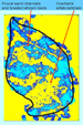 Figure
2. A horizontal slice through a 3D cube of resistivity data consisting
of 9000+ log traces.
Figure
2. A horizontal slice through a 3D cube of resistivity data consisting
of 9000+ log traces. Figure
3. A-D. Outcrops of Kern River Formation, showing typical examples of
the fluvial deposits of the Kern River alluvial fan.
Figure
3. A-D. Outcrops of Kern River Formation, showing typical examples of
the fluvial deposits of the Kern River alluvial fan. Figure
4. 3D model of the KRF showing lithology, oil
Figure
4. 3D model of the KRF showing lithology, oil  Figure
6. Well log (A), cored section (B), thin-sections (C), particle-size
analysis (D), and capillary-pressure data (E) of KRF in TOL004-XTO. C.1.
Calcite ‘grains’ in poorly sorted porous coarse sand. Calcite grains
formed through leaching and crushing of coarse crystalline calcite
cement. Scale bar is 1 mm.
Figure
6. Well log (A), cored section (B), thin-sections (C), particle-size
analysis (D), and capillary-pressure data (E) of KRF in TOL004-XTO. C.1.
Calcite ‘grains’ in poorly sorted porous coarse sand. Calcite grains
formed through leaching and crushing of coarse crystalline calcite
cement. Scale bar is 1 mm.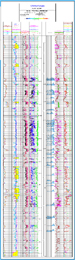 Figure
7. Log suite, including plots of
Figure
7. Log suite, including plots of 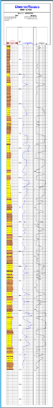 Figure
10. Lithologic and interpretive log suite of KRF reservoirs in MIT0020
(courtesy of Paul Harness, formation evaluation specialist). From left
to right, the log shows the lithology (sandstone and siltstone), a
resistivity curve, and a heat-corrected permeability curve based on the
conductivity measurement.
Figure
10. Lithologic and interpretive log suite of KRF reservoirs in MIT0020
(courtesy of Paul Harness, formation evaluation specialist). From left
to right, the log shows the lithology (sandstone and siltstone), a
resistivity curve, and a heat-corrected permeability curve based on the
conductivity measurement. Figure
11. Photomicrographs of samples of KRF in MIT0020 (A), corresponding
particle-size analyses (B), and capillary-pressure data (C). A.1. Poorly
sorted sand exhibiting variable porosity. Many of the fine sand grains
formed through leaching and crushing of plagioclase. Leaching of
plagioclase was accompanied by precipitation of kaolinite cement (red
arrow). Scale bar is 1 mm. A.2. Poorly sorted coarse sand containing
abundant biotite with long axes aligned parallel to bedding. Scale bar
is 1 mm. A.3. Poorly sorted granule conglomerate exhibiting crushed
plagioclase and fractured quartz. Prior to fracturing/crushing this sand
was probably well sorted. Scale bar is 1 mm. B. Laser particle-size
analysis shows unimodal distributions for all three samples and a
fining-upward sequence. C. Capillary-pressure data indicate that the Swir
values for the rocks approached 12% (88% So).
Figure
11. Photomicrographs of samples of KRF in MIT0020 (A), corresponding
particle-size analyses (B), and capillary-pressure data (C). A.1. Poorly
sorted sand exhibiting variable porosity. Many of the fine sand grains
formed through leaching and crushing of plagioclase. Leaching of
plagioclase was accompanied by precipitation of kaolinite cement (red
arrow). Scale bar is 1 mm. A.2. Poorly sorted coarse sand containing
abundant biotite with long axes aligned parallel to bedding. Scale bar
is 1 mm. A.3. Poorly sorted granule conglomerate exhibiting crushed
plagioclase and fractured quartz. Prior to fracturing/crushing this sand
was probably well sorted. Scale bar is 1 mm. B. Laser particle-size
analysis shows unimodal distributions for all three samples and a
fining-upward sequence. C. Capillary-pressure data indicate that the Swir
values for the rocks approached 12% (88% So).  Figure
13. Photograph of Kern River field in 1899.
Figure
13. Photograph of Kern River field in 1899.