Click on image for enlargement.
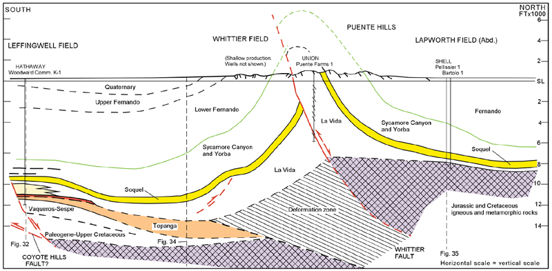
Figure 33. Leffingwell oil field to Whittier oil field and the Puente Hills. This section is located near the point at which the strike of the Whittier fault changes from N70W to nearly due north (Figure 4). Although only three wells, Union Puente Farms 1 and Shell Pellissier 1 and Bartolo 1, are shown on the cross section near the Whittier fault, the structure at the top of the Soquel Member is well delineated. Wells off the section and outcrop data establish the south dip of the strata in the footwall block and the north dip in the hanging wall block. The Shell wells penetrated a thin section of strata equivalent to the Yorba, Soquel, and La Vida Members overlying metamorphic basement rocks. The La Vida siltstone is less than 1000 feet thick (Yeats and Beale, 1991) in Pellissier 1. The stratigraphic thickness of the La Vida Member in the Puente Farms 1 is about 4000 thick, an increase in thickness of more than 3000 feet over a distance of less than 13000 feet. This suggests the La Vida strata onlapped a basement surface that dipped 15 degrees to the south. The kinematic problem of determining the deformational history that led to the present configuration of that wedge of La Vida siltstone has not been completely resolved. Both the transition from predominantly dip-slip movement to strike-slip movement on the north-trending segment of the Whittier fault in the vicinity and detachment folding may play a role in the development of the structure. The structure of the footwall block below the Soquel Member is schematic. The location of the anticline is compatible with the inversion of a thick wedge of La Vida siltstone. Oil stain and fractures in cores suggest the presence of the Whittier fault in the Puente Farms 1 well. However, the fault geometry, the shape of the deformed basement wedge, and the kinematics that led to the inverted structure are not well known. At total depth in the Bartolo 1 well, fractured silver-gray slate has been reported. At total depth in the Pellissier 1 well, fractured, blue-green metamorphic rock with very fine-grained to "granitic texture" has been reported. These basement rocks are probably equivalent to the slate penetrated by several wells north of Montebello oil field (Figure 5). Refer to Figure 32 for a discussion of the interpretation of the Leffingwell oil field structure. The location of the Coyote Hills fault at Leffingwell is based entirely on an interpretation of reflection seismic data (Shaw and Shearer, 1999).