Click on image for enlargement.
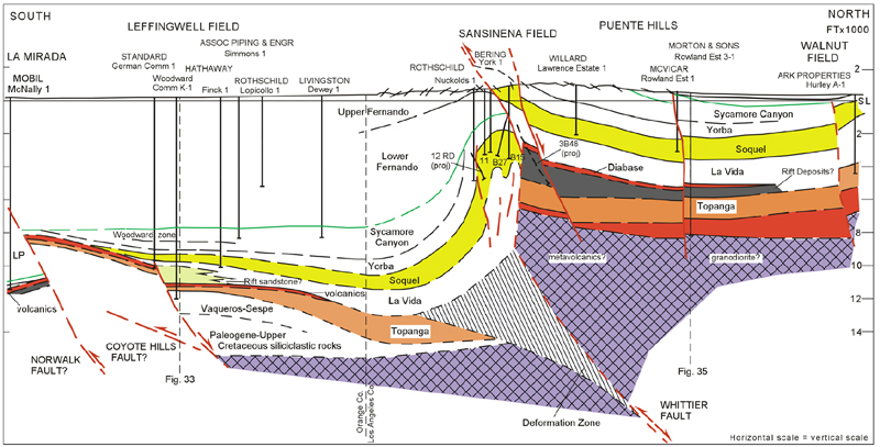
Figure 32. La Mirada oil field to Leffingwell and Sansinena oil fields and the Puente Hills. The interpretation shown on this cross section has been modified from Yerkes (1972) and West and Redin (1991). The Coyote Hills fault, proposed by Shaw and Shearer (1999), has been added as a possible alternative interpretation of the Norwalk fault (?). The simplified interpretation of Sansinena field is based mainly on data provided by Nuevo Energy Company and Union Oil Company and a published report by Woodward (1958). The tightly folded anticline in the footwall block has been established by well data at the top of the Soquel Member. The anticline has also been mapped at the surface in the Upper Fernando Member and named the Sansinena nose by the operator (unpublished map, Hoots and Kinney, 1939). Sansinena 3B48 has been projected to show stratigraphy only and does not reflect the subsea position of the well. The details of the structure and stratigraphy in the core of the footwall anticline below the top of the Soquel sandstone are largely schematic. The basement geometry of the Whittier fault satisfies constraints for conserving bed length and area during deformation but is not a unique interpretation. The kinematic problem of inverting and rotating a half-graben to produce the Sansinena structure has not been completely resolved. The interpretation of Leffingwell oil field that has been depicted on this cross section is speculative. A conglomeratic sandstone nearly 800 feet thick in the Hathaway Woodward Community K-1 well, which is absent in the Standard German Community 1 well just 1400 feet to the south, had been correlated with the Soquel Member, and a volcanic unit in both wells had been interpreted to dip about 40 degrees north (Yerkes, 1972, Section D-D’, Plate 2). The overlying Yorba Member and younger strata were shown to be horizontal and undeformed. This interpretation requires the development of a compressive structure between ca. 14 Ma and 8 Ma, which would not be likely in a region that was undergoing extension during that time period. The interpretation shown on this cross section separates the German Community and Woodward Community wells with a graben-forming normal fault that dips north. The conglomeratic sandstone would then correlate with the lower La Vida and represent a rift deposit in a small half-graben (cf. Bjorklund and Burke, 2002). Further investigation of the Leffingwell field area is beyond the scope of this study, but data may be available in the West Coyote oil field area to evaluate the viability of a half-graben interpretation.