![]() Click to view figures in PDF format.
Click to view figures in PDF format.
The Power of Multiple Seismic Attributes in Revealing Geologic Understanding*
By
Walter E. Johnson1, Richard O. Louden2, Donald D. Lehman3, and Duncan L. Edwards4
Search and Discovery Article #40067 (2002)
*Adapted for online presentation from the Geophysical Corner column in AAPG Explorer, March, 2001, entitled “Seismic Has Its Multiple Attributes,” and prepared by the authors. Appreciation is expressed to the authors, to R. Randy Ray, Chairman of the AAPG Geophysical Integration Committee, and to Larry Nation, AAPG Communications Director, for their support of this online version.
Editor’s note: Please refer to related article, “3-D Seismic Data in Delineating Productive Ismay Algal Mounds in Southern Paradox Basin, Utah,” by the same authors previously posted on Search and Discovery.
1Consulting geophysicist, Denver, Colorado.
2Consulting geologist affiliated with Thomasson Partner Associates, Denver, Colorado. 3Former exploration manager for Miller Energy, is now with VuCom Data Services in Kalamazoo, Michigan.
4Independent consulting geophysicist in Rutherfordton, N.C.
Analysis of 3-D seismic data with
several types of seismic attributes can reveal geologic factors that control the
location of productive algal mound reservoirs in the Paradox Basin. Routine
seismic mapping of the producing interval did not reveal the presence of a
regional strike-slip fault that is clearly shown using ![]() attribute
attribute![]() analysis. This
previously unknown strike-slip fault controls the local stratigraphy and extends
for over 30 miles.
analysis. This
previously unknown strike-slip fault controls the local stratigraphy and extends
for over 30 miles.
Although each ![]() attribute
attribute![]() when used
alone has some level of ambiguity, it is important to note that when a number of
attributes with different mathematical algorithms yield similar results, the
reliability of the geologic interpretation is enhanced. Several commercially
available seismic attributes, along with attributes generally incorporated
within most workstations, collectively have had a significant impact on the
understanding of how and where the algal mound reservoirs form, and indicate
that their stratigraphic development is often not a random act. The purpose of
this article is to demonstrate that the small cost of time and money required to
perform
when used
alone has some level of ambiguity, it is important to note that when a number of
attributes with different mathematical algorithms yield similar results, the
reliability of the geologic interpretation is enhanced. Several commercially
available seismic attributes, along with attributes generally incorporated
within most workstations, collectively have had a significant impact on the
understanding of how and where the algal mound reservoirs form, and indicate
that their stratigraphic development is often not a random act. The purpose of
this article is to demonstrate that the small cost of time and money required to
perform ![]() attribute
attribute![]() analysis is far outweighed by the increased understanding of
the geologic dynamics of an area.
analysis is far outweighed by the increased understanding of
the geologic dynamics of an area.
The ability to map more geologic detail will ultimately result in reduced risk of drilling dry holes.
|
uAlgal mound reservoirs in Paradox Basin
uAlgal mound reservoirs in Paradox Basin
uAlgal mound reservoirs in Paradox Basin
uAlgal mound reservoirs in Paradox Basin
uAlgal mound reservoirs in Paradox Basin
uAlgal mound reservoirs in Paradox Basin
|
Click here to view sequence of Figures 3 and 4, (Hovenweep amplitude and Upper Ismay isochron maps).
Click here to view sequence of
Click here to view sequence of Figures 11 and 12. Algal Mound Reservoirs in the Paradox Basin Miller Energy, of Kalamazoo, Michigan, and its partners completed the Miller Horse Canyon 1-10 in 1998 for an initial potential of 960 barrels of oil per day and 940 MCFG/D from a depth of 5,850 feet from an algal mound reservoir. The well was featured in the 1999 EXPLORER. Figure 1 shows the location of the Paradox Basin in the southwestern United States, where shelf carbonate buildups within the Pennsylvanian basin have produced oil and gas since the 1950s. Generally these carbonate buildups are the result of algal debris from Ivanovia (these Ivanovia algal skeletons are much the same size as cereal corn flakes). In the 1980s it became generally known that there could be a seismic expression resulting from these carbonate buildups, but the 2-D seismic data that existed then added little to the understanding of the genesis of these features.
Figure 2, a geologic cross section through the discovery well, is a
good reference for the various geologic strata that will be mentioned
throughout this article. The well was completed in an Upper Ismay
carbonate buildup; however, the test also encountered a deeper Desert
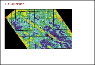
Creek carbonate buildup that is further revealed with A seismic tuning effect owing to thickness changes in the Hovenweep shale creates a mappable high amplitude that indicates where the shale is extra thick, as shown in Figure 3. This thick resulted in a positive “island” that existed during the time of deposition of the Upper Ismay. The island is outlined in black and will be shown on subsequent displays. Note in Figure 2 how the Hovenweep thick is located to the left of the discovery well. The isochron thickness map of the Upper Ismay (from the top of the Hovenweep to the top of the Upper Ismay) shown in Figure 4 demonstrates that there is an atoll shape of increased thickness of Upper Ismay surrounding the Hovenweep island. A series of different
seismic An Another It is important to note
that both the wavelet classification map and the multivariate Edge detection technology has been used in the seismic industry for several years, and is designed to compare each trace of the data with its neighbors in order to map dissimilarities. Figure 8 is the edge detection horizon slice of the Upper Ismay horizon. A fault was interpreted through the linear discontinuity on the horizon slice. This package also has the advantage that it creates a cube of data output that can be loaded on the workstation to be interpreted at different time or horizon slices.
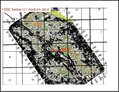
Figure 9 is another Figure 10 is an amplitude map of the top of the Akah salt, and it is believed that the dim shown in green and red is the result of salt dissolution. Note how the amplitude dim conforms with the overlying Hovenweep thick. We postulate that the fault may have been a conduit to cause dissolution of the Akah salt. A horizon slice slightly above the Akah salt has a very distinctive linear pattern that also could be the result of differential salt dissolution. As another Many workstations have add-on packages that allow some trace processing. A horizon windowed seismic wiggle from the area of the producing well was cross-correlated with the entire 3-D volume, and those areas that had similar correlation values were mapped on the workstation to produce Figure 12. Note the similarity between Figures 12 and 6 . Both the cross-correlation and wiggle classification mapping techniques indicate strong potential for new drill site locations on the south side of the Hovenweep “island.” The enhanced geologic
understanding gained from the various The similar patterns that emerge by running many different techniques reinforces the interpreter’s confidence when mapping subtle geologic variations. This improved geologic understanding leads to reduced risk in both development and exploration projects.
Often seismic interpreters are discouraged from mapping anything but the
primary producing zone. Our experience on this stratigraphic play shows
that |
 Figure
1. Location of Paradox Basin.
Figure
1. Location of Paradox Basin. Figure
2. Stratigraphic cross section through the discovery.
Figure
2. Stratigraphic cross section through the discovery. Figure
5. Desert Creek amplitude map showing NW-SE lineament.
Figure
5. Desert Creek amplitude map showing NW-SE lineament. Figure
6. Wavelet classification map output at Upper Ismay horizon showing
NW-SE lineament.
Figure
6. Wavelet classification map output at Upper Ismay horizon showing
NW-SE lineament. Figure
8. Edge detection horizon slice through Upper Ismay.
Figure
8. Edge detection horizon slice through Upper Ismay. Figure
9. Edge detection horizon slice approx. 1500 ft below Upper Ismay.
Figure
9. Edge detection horizon slice approx. 1500 ft below Upper Ismay. Figure
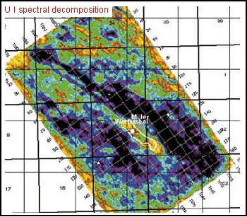
11. Spectral decomposition at the Upper Ismay showing NW-SE fault along
with other features.
Figure
11. Spectral decomposition at the Upper Ismay showing NW-SE fault along
with other features.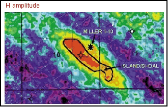