![]() Click to view this article in PDF format.
Click to view this article in PDF format.
3-D Seismic Data in Delineating Productive Ismay Algal Mounds in Southern Paradox Basin, Utah*
By Richard O. Louden1, Donald D. Lehman2, Walter E. Johnson3, and Duncan L. Edwards4
Search and Discovery Article #40048 (2002)
*Adapted for online presentation from an article by the same author in AAPG Explorer (May, 1999), entitled “3-D Scores Algal Mound Discovery.” Appreciation is expressed to the author and to M. Ray Thomasson, former Chairman of the AAPG Geophysical Integration Committee, and Larry Nation, AAPG Communications Director, for their support of this online version.
1Consulting geologist ([email protected]), Thomasson Partner Associates
2VuCom Data Services, Inc. (www.vucomdata.com)
3Consulting geophysicist ([email protected]), Thomasson Partner Associates
4Independent consulting geophysicist
|
|
Click here for sequence of Figures 2 and 3. Click here for sequence of Figures 2 and 3. Click here for sequence of Figures 4, 5, and 6. Click here for sequence of Figures 4, 5, and 6.
Click here for sequence of Figures 4, 5, and 6.
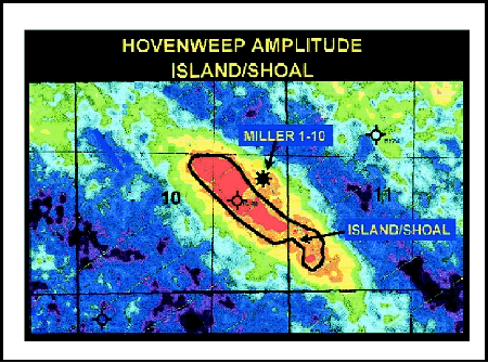
General StatementIn early 1998, Miller Energy of Kalamazoo, Mich., scored one of the best Ismay algal mound discoveries of decade in the southern Paradox Basin. The prospect was drilled on a 10-square-mile 3-D seismic program. Miller used a dynamite source in 80-foot shot the holes. Bin size was 110 feet x 110 feet. Good Upper Ismay algal mound production was established in the early 1980s in the same province. Miller based its project on 2-D seismic anomalies mapped by Thomasson Partner Associates. Nevertheless, finding Upper Ismay mounds with 2-D data alone is a little like trying to pick up a wet cake of soap on the shower floor in the dark. The crest of the mound has a way of slipping sideways away from the drill bit. Miller’s subsequent 3-D program, on the other hand, nailed the crest of the best mound “dead-on” with the first well. The proper migration of steep dips on mound flanks provides a more accurate areal shape for the mound. This greatly increases the chances for a successful first well – a critical factor in keeping joint venture partners on-board. Miller and partners drilled and completed the 1-10 Horse Canyon Federal, which is the discovery well for Horse Canyon Field. The field is located in the western portion of the Blanding sub-basin of the southern Paradox Basin (Figure 1). The discovery well had an initial potential, flowing, of 960 BOPD and 940 MCFGPD (no water). The well has been producing since July 1998, flowing at the highly restricted rate of 230 BOPD and 200 MDFGPD. It produced 48,837 BO and 37 MMCFG through March 1, 1999. The reservoir is a porous and highly permeable limestone in the algal mound facies of the Upper Ismay (Figure 2). The drive mechanism appears to be solution gas. The reservoir does not appear to have any associated water. The GOR has remained relatively constant at approximately 800 to 1000 scf/bbl. Directly beneath the producing horizon is another potentially productive zone in the Upper Ismay. This uncompleted zone is a dolomite with higher porosity than the perforated zone. Potential pay zones also have been identified in the lower Desert Creek and lower Ismay intervals of the Paradox Formation in the project area. The Ismay and Desert Creek members are in the upper five cycles of the Pennsylvanian Paradox Formation, of which there are more than 40 upward shoaling cycles identified. To date (May, 1999), there has been little exploration for carbonate reservoirs in the lower 35 cycles, making the Paradox one of the least drilled proved petroleum basins in the United States. Choice of DrillsiteThe drillsite was chosen mainly on the basis of a reduced amplitude “dim” of the Upper Ismay event. Figure 3 is a northeast oriented profile passing through the discovery well and dry hole (the Wintershall, 10-43 Ute Canyon Federal, a well drilled in 1984, 780 feet west of the new Miller well). The geologic cross-section in Figure 2 passes through the same wells. The Upper Ismay anhydrite (the light blue event in Figure 3) provides a strong reflector at the top of the Upper Ismay. Where the Anhydrite pinches out on the side of the porous mound, the event becomes dim. Passing southwestward, the event strengthens at the dry hole, becomes slightly dim to the west of the dry hole (another possible mound), then increases in amplitude toward the southwest end of the profile. Genesis of Upper Ismay MoundThe model for mound development consists of a thickened Hovenweep Shale providing a shoal or island in the Upper Ismay sea. Note on the cross-section (Figure 2) that there is a thickened Hovenweep Shale, which is 47 feet thick in the dry hole but only 20 feet thick at the Miller discovery. The shale can be seen as a high amplitude event under the mound on Figure 3 (the yellow line). Figure 4 is an amplitude map of the Hovenweep event, showing the shape of the island inside the black line. The black outline of the island is carried forward to the other figures. A thick Hovenweep Shale is associated with all Upper Ismay mound production in the Blanding sub-basin. The algal mound develops on either side of the Hovenweep thick, perhaps wrapping around the shale thick to form an atoll. This atoll is illustrated on two maps. Figure 5 displays the amplitude of the Upper Ismay event. The dim areas in red and yellow are shown to be on either side of the Hovenweep island but not in the middle, where the dry hole is located. If mound growth had been more robust, possibly mound debris would have washed into the central lagoon providing an Upper Ismay reservoir at the location of the dry hole. A somewhat more dramatic presentation of the atoll shape is shown on the map of Figure 6. This is an isochron from the Hovenweep Shale event to the Upper Ismay event. The interval includes the productive mound. Again, it is clear that an Upper Ismay Algal mound (red, yellow and green) is built around the fringe of the Hovenweep island. The central lagoon and shoal waters surrounding the mounds are shown in shades of blue. Secondary objectives seem to be easier to find and analyze on high quality 3-D data. A Desert Creek mound is indicated northeast of the Miller well on the profile of Figure 3 and the cross-section of Figure 2. On Figure 7 a possible mound trend shows as a red and yellow amplitude dim passing northwesterly across the entire shoot. This has not been drilled – but nearby wells do have porosity and possible calculated pay. ConclusionsMiller and Thomasson have shown that 3-D seismic can locate carbonate reservoirs in areas already saturated with old 2-D data. Three-D interpretation can be done in sufficient detail as to document the genesis of a mound. Miller found sufficient encouragement from its Horse Canyon success to extend the program to the north as shown by the Mustang Flat 3-D program, currently (1999) in progress (Figure 8). There has been little exploration for pre-Ismay mounds in the western Blanding Basin, but new 3-D programs based on 2-D interpretations will open this province. Return to top. |
 Figure 1. Index map of Horse Canyon Field,
western part of Blanding sub-basin, southern Paradox Basin, Utah.
Figure 1. Index map of Horse Canyon Field,
western part of Blanding sub-basin, southern Paradox Basin, Utah. Figure 2. Stratigraphic cross-section of part
of the Pennsylvanian Paradox Formation, which includes the
reservoir-bearing Ismay and Desert Creek members.
Figure 2. Stratigraphic cross-section of part
of the Pennsylvanian Paradox Formation, which includes the
reservoir-bearing Ismay and Desert Creek members. Figure 3. 3-D seismic profile through
discovery well (Miller 1-10 HCF), with the mound being shown by the
Upper Ismay Anhydrite reflector above part of the rather local
development of Hovenweep Shale.
Figure 3. 3-D seismic profile through
discovery well (Miller 1-10 HCF), with the mound being shown by the
Upper Ismay Anhydrite reflector above part of the rather local
development of Hovenweep Shale. Figure 4. Amplitude map of the Hovenweep
event, showing the shape of the island/shoal (inside the black line)
formed by thickening of this shale.
Figure 4. Amplitude map of the Hovenweep
event, showing the shape of the island/shoal (inside the black line)
formed by thickening of this shale. Figure 5. Amplitude map of Upper Ismay event,
with outline of Hovenweep shoal. “Dim” areas (in red and yellow) are on
either side of the shoal/island.
Figure 5. Amplitude map of Upper Ismay event,
with outline of Hovenweep shoal. “Dim” areas (in red and yellow) are on
either side of the shoal/island. Figure 6. Isochron map of interval from the
Hovenweep event to the Upper Ismay event, showing atoll.
Figure 6. Isochron map of interval from the
Hovenweep event to the Upper Ismay event, showing atoll. 
 Figure 8. Location map of subsequent Mustang
Flat 3-D program.
Figure 8. Location map of subsequent Mustang
Flat 3-D program. 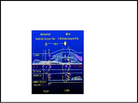