|
Figure Captions
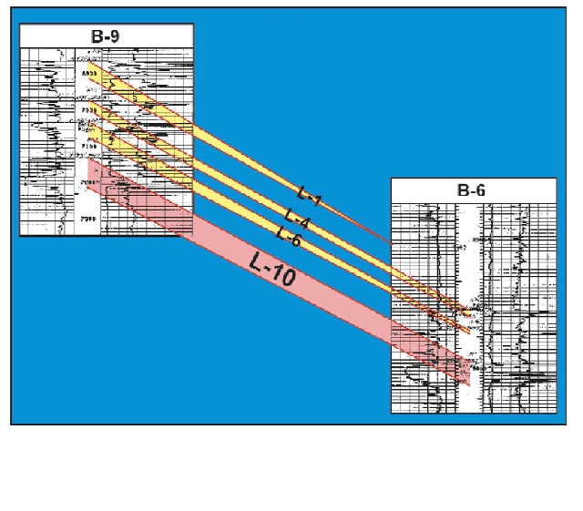
 Figure 2.
First generation subsurface
cross-section (well locations in Figure 5),
showing correlation between the B-6 and B-9 wells. L-10 subject horizon
highlighted, in red Figure 2.
First generation subsurface
cross-section (well locations in Figure 5),
showing correlation between the B-6 and B-9 wells. L-10 subject horizon
highlighted, in red
 Figure 3.
Chart comparing BHP's from the L-10 reservoir in the B-6 and B-9 wells Figure 3.
Chart comparing BHP's from the L-10 reservoir in the B-6 and B-9 wells
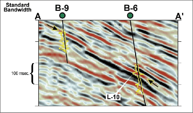
 Figure 4.
Standard bandwidth Figure 4.
Standard bandwidth  3-D 3-D arbitrary profile (A-A') connecting the B-9 and
B-6 wells. Arrows indicate the reflector under investigation.
SP log
tracts appear to the left of well bore projections with resistivity to
the right. Red represents negative reflection coefficients on the
seismic color bar. arbitrary profile (A-A') connecting the B-9 and
B-6 wells. Arrows indicate the reflector under investigation.
SP log
tracts appear to the left of well bore projections with resistivity to
the right. Red represents negative reflection coefficients on the
seismic color bar.
 Figure 5.
Location map of wells and seismic lines. (arbitrary profiles A-A'
[Figures 4 and 7]
and B-B' [Figures 9 and
10]). Figure 5.
Location map of wells and seismic lines. (arbitrary profiles A-A'
[Figures 4 and 7]
and B-B' [Figures 9 and
10]).
 Figure 6.
Revised subsurface cross-section based on standard bandwidth 3-D
seismic.
Note increased complexity of correlations compared to
Figure 2 Figure 6.
Revised subsurface cross-section based on standard bandwidth 3-D
seismic.
Note increased complexity of correlations compared to
Figure 2
 Figure 7. The same traverse (A-A') as seen
in Figure 4 shown in high frequency.
Dominant frequency is roughly 80 hz.
Arrows indicate equivalent reflector to
Figure 4.
Reflector termination is also shown by arrow. Figure 7. The same traverse (A-A') as seen
in Figure 4 shown in high frequency.
Dominant frequency is roughly 80 hz.
Arrows indicate equivalent reflector to
Figure 4.
Reflector termination is also shown by arrow.
Click here to view sequence of seismic line
(A-A’), standard bandwidth and high frequency (Figures 4 and 7,
respectively).
 Figure 8.
Revised subsurface cross-section based on frequency enhanced 3-D
seismic. Compare with
Figure 6. Figure 8.
Revised subsurface cross-section based on frequency enhanced 3-D
seismic. Compare with
Figure 6.
Click here to
view sequence of interpretations of cross-section between B-9 and B-6
wells (Figures 2, 6, 8 in order of enhancement).
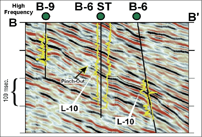
 Figure 9.
A high frequency profile (B-B') incorporating the newly drilled B-6 ST
well. The L-10 reflector is tracked by the black line and the stratigraphic separation (pinchout) is highlighted by the arrow. Figure 9.
A high frequency profile (B-B') incorporating the newly drilled B-6 ST
well. The L-10 reflector is tracked by the black line and the stratigraphic separation (pinchout) is highlighted by the arrow.
 Figure 10.
Shown here is the same profile (B-B') as
seen in
Figure 9 but in the standard bandwidth format.
The stratigraphic
separation is still imaged in this particular view. Figure 10.
Shown here is the same profile (B-B') as
seen in
Figure 9 but in the standard bandwidth format.
The stratigraphic
separation is still imaged in this particular view.
Click here to view
sequence of seismic profile (B-B’), high frequency (Figure 9) and
standard bandwidth (Figure 10).
 Figure 11.
Final cross-section incorporating newly
drilled B-6 ST. L-10 reservoir addition proven by B-6 ST is shown by
yellow and green hachured area. Figure 11.
Final cross-section incorporating newly
drilled B-6 ST. L-10 reservoir addition proven by B-6 ST is shown by
yellow and green hachured area.
Return
to top.
The example used here comes from South Marsh
Island Block 128 Field (Figure
1). The discovery well for this prolific field was drilled in June
1974. The field is a stratigraphically complex, salt cored NW-SE
trending anticline bounded on the west by a large down-to-the-west
fault.
Reservoir age ranges from Angulogerina B
(Early Pliestocene) to Lenticulina 1 (Late Pliocene) at depths of 4,500
to 9,000 feet subsea. Paleobathymetry ranges from inner neritic at the
shallower levels to upper bathyl in the deeper zones, with all
reservoirs being normally pressured.
The field has seven exploratory wells and 93
development wells, including sidetracks, drilled from four offshore
platforms. In January 2000, cumulative production was 115 MMBO and 203
BCF, and average daily production rates were 3,500 BO and 4 MMCF.
Structural interpretation there had been
difficult from the outset with various interpreters producing different
structural pictures (the lack of seismically mapped faulting was the
variable in the interpretations). Even with the acquisition of
proprietary, first generation 3-D seismic in 1989, the uncertainties
persisted.
The geoscientists working the field were aware
of the stratigraphic variations between wells but were hard pressed to
visualize this level of depositional complexity with the currently
available seismic. Distinguishing between faulting and stratigraphic
discontinuities was problematic at best, leading to complex fault
patterns that were suspiciously "ungeologic." Furthermore, many of the
reservoir thicknesses were below standard seismic resolution -- thus
impossible to map with much reliability.
A 1994 vintage speculative 3-D dataset was
reprocessed in early 1998, employing target-oriented prestack Kirchoff
time migration in an attempt to resolve some of these issues. Field
acquisition employed a 4,000-meter streamer with 25-meter group and shot
intervals, four millisecond sample rate and an eight second record
length. A 15,000-foot migration aperture was selected to optimize
imaging of dipping reflectors. Overall imaging was greatly improved,
leading to the conclusion that many of the discontinuities previously
interpreted as faulting were in fact stratigraphic variation. Pressure
data supported the fact that certain wells were in separate
compartments, but this was still not clearly imaged in the 3-D seismic.
In hope of resolving these stratigraphic
details, a post-stack frequency enhancement routine was applied to the
reprocessed data. This technique employs a branch of mathematics
originally developed in quantum mechanics for treating technically
unsolvable systems (undetermined equations) in combination with the math
evolved for the decoding of encrypted messages. After all, this is
essentially what the seismic trace is.
In the data set, two wells were selected as
calibration wells. The selection criteria dictated that good quality
logs of velocity and density data be available for synthetic seismogram
generation. Velocity survey information also was incorporated. The logs
were carefully edited by experienced petrophysicists to compensate for
washouts, cycle skipping and any other problems. The consequent
reflectivity series were convolved with 50, 60, 75 and 80 hertz Ricker
wavelets to produce synthetic seismograms. These served as calibration
points and quality control for the seismic processing.
The synthetic traces were compared to the data
to optimize parameters of the high frequency data volume. At frequencies
approaching 120 hertz, non-geologic "artifacts" or events not
correlative to the log-generated synthetic traces appeared in the data,
so the data was filtered back to the point where these artifacts
disappeared. The resultant high frequency data was integrated with well
information to identify and evaluate new drilling targets. Acoustic
impedance inversion was also employed to support the results and, in
some cases, was a determining factor for picking drillsites.
In June 2000, the partners initiated a
multi-well drilling program to test some of the identified
opportunities, including two wells drilled early in the field's
development.
-
The B-6 was drilled in the
field's southern portion in April 1976 and encountered 47 feet of net
oil pay in two zones.
-
The B-9 was drilled 2,300
feet to the southwest of the B-6 in June 1976 and encountered 149 feet
of net oil pay in four zones.
Both are directional platform wells drilled
into generally east dipping strata with no water contacts encountered by
either well in any pay zone.
For this article we concentrate on a reservoir
referred to as the L-10 zone, a Lentic-1 age horizon. The first
generation interpretation (Figure
2) shows a geologist's subsurface log cross-section between the B-6
and B-9 wells connecting all of the L series sands (L-1 thru L-10). Note
that the L-1 zone in the updip B-9 wellbore is interpreted as absent in
the down dip B-6 wellbore. All other L series horizons (L-4, 6 and 10)
are shown to be continuous except for variations in thickness and log
character. This correlation generally was accepted by the partners
during the early stages of field development. However, after years of
production, the bottom hole pressure (BHP) profiles show a divergent
trend between these two zones (Figure
3), demonstrating that they could not be in communication with each
other. Furthermore, the L-10 zone (-7021 SSTVD) in the B-9 well watered
out in September 1991, after producing 2,083 MBO and 2,369 MMCF. The
L-10 completion (-7587 SSTVD) in the B-6 well continued to produce until
watering out in April 1994 after recovering 539 MBO and 690 MMCF.
How do we explain the fact that the updip well
watered out before the down dip well? Clearly some type of stratigraphic
separation exists, but can we define it with seismic data?
Return
to top.
Before the application of the frequency
enhancement technique, the standard-frequency reprocessed version of the
1994 vintage speculative 3-D data (Figure
4) was used to study the accuracy of reservoir correlations.
Figure 5 shows the location of an arbitrary seismic line from the
3-D volume as A-A'. It directly connects the B-6 and B-9 wells, showing
their SP and resistivity log curves overlain on the data. The red trough
seismic event representing the L-10 is indicated by the arrows.
Note that the reflector is essentially
continuous between the B-6 and B-9 wells. This leads to a revised
cross-section (Figure
6) where the L-10 sandstone correlation from the B-6 well has
shifted to a shallower sand in the B-9 well. Maintaining the original
nomenclature for the reservoirs, the L-4 and L-6 zones in the B-6 well
are now shown as absent in the B-9 well. More importantly, the L-10 zone
of interest ties to a continuous reflector that now connects it to what
was previously identified as the L-1 in the B-9 well. A revelation?
Maybe -- but does other information verify this? Records indicate that
there is a pressure difference of over 1,000 psi between these two
zones, suggesting that they cannot be in the same reservoir.
Once again standard bandwidth seismic fails to
resolve the correct correlation. Remember, we want to image a zone that
according to logs is on the order of 20-40 feet in gross thickness.
Although our data quality is very good, we are limited by the inherent
bandwidth of the data. The dominant frequency in the zone of interest is
roughly 25 hertz with the high end imaging at 48 hertz. The interval
velocity is 8,850 feet/second, making the dominant tuning thickness
about 89 feet (1/4 wavelength) with the thinnest possible resolution at
47 feet.
We may expect to see a reflection at the top
of the zone, but imaging the base is not achievable -- and, due to
bandwidth limitations, not resolvable as a separate seismic event. The
pay is not associated with a classic "bright spot," so an amplitude
extraction does little to reveal any reservoir boundaries. In addition,
the 3-D seismic suggests that the separation is not fault-related. Yet
pressure and production data confirm that we are dealing with two
separate reservoirs. The separation must be stratigraphic. It is now
time to apply the high frequency version of the 3-D dataset to see if it
can image what we know exists.
Frequency Enhancement
Figure 7 is the same A-A' arbitrary seismic line shown in
Figure 4, except that the frequency enhancement technique has been
applied. The dominant frequency is now 45 hertz, making the dominant
tuning thickness roughly 49 feet. The upper end signal frequencies,
however, extend to 80 hertz, allowing resolution of beds as thin as 27
feet.
The individual reservoir units now begin to
tie discreet events on the seismic. The zone of interest is again
indicated by the arrows. Note that the event that ties the L-10 zone in
the B-6 well appears to have a break or termination before it reaches
the B-9 well. It is interpreted as a stratigraphic pinchout and explains
the reservoir separation indicated by the pressure and production data.
This prompts a reinterpretation of the geologic cross-section (Figure
8) that honors the break in correlation seen by the high frequency
data. This version exhibits more stratigraphic discontinuity than any
previous interpretation. It also offers an interpretation that
reconciles the pressure and production history and defines a new
drilling target.
Return
to top.
Although
the data hinted at a more complex stratigraphic interpretation, but it
became clear that the standard bandwidth seismic data would be unable to
image the thicknesses of many of the sand units seen in the wells. The
decision was made to apply a new frequency enhancement technology to the
newly reprocessed 3-D seismic data set to see if the vertical resolution
could be improved.
In this
case, the algorithm works to decode the seismic "message" and extract
the acoustic reflectivity series directly from it. The operation is
entirely mathematical, with no wavelet estimation or other interpretive
input applied. The primary requirement is a seismic trace with
reasonably good signal-to-noise ratio.
The
high-frequency technique considers the broad-band reflectivity series,
or "earth signal," to be convolved with the band-limited embedded
wavelet through the process of polynomial multiplication (one-sided
convolution). The new method used here takes an alternative approach by
describing one-sided convolution as a matrix multiplication with the
problem resembling a process used to decode encrypted messages.
This way,
the earth reflectivity is not viewed as being filtered but rather
"encoded," with the upper portion of the spectrum not removed but
encrypted in the lower end of the spectrum, which is still observable.
By treating the seismic trace in this domain, it can be manipulated to
increase the high frequency signal without boosting the ambient noise.
Consequently, the signal emerges from beneath the noise level and is
recoverable.
The
resultant signal is very similar to the original "earth signal" or
unconvolved reflectivity series and produces a reasonable estimate of
the reflectivity series with greater resolution than the input seismic
trace. Since the entire spectrum is encoded by the embedded wavelet, it
is theoretically possible to regain frequencies up to Nyquist frequency
(half the sampled frequency) on properly recorded and processed data.
The
reprocessed high-frequency version of the seismic data noted above
revealed an apparent undrained reservoir in our zone of interest.
Recalling that the L-10 zone in the B-6 well was productive, and
observing that we can penetrate this reservoir updip to the B-6 take
point without a break in continuity, leads to the obvious conclusion
that we have defined a new drilling target not previously recognized.
In
November 2000 a sidetrack of the B-6 well was spudded to test the
prospect. The well reached total depth and was logged in early December.
Logs revealed oil pay in three zones for a total of 52 feet of net oil
pay, 26 feet of which were in the L-10 zone of interest -- with no water
contact present! Independent engineering calculations assigned 407 MBO
and 183 MMCF of new proved reserve additions to the field, with 203 MBO
coming from the zone of interest.
Figure 9
shows a frequency enhanced arbitrary 3-D extracted line, B-B', that
incorporates the new B-6 ST with the older B-6 and B-9 wells. The
location of this traverse is shown in
Figure 5. Again the target horizon is indicated in the B-6 and the
new B-6 ST wellbores with the black line tracking the seismic event
related to the horizon. The discontinuity marked by the arrow separates
the B-6 and B-6 ST from the updip B-9 well. This interpretation agrees
with the separation implied by the pressure data.
In
Figure 10, the normal bandwidth version of this line is displayed
for comparison. The discontinuity visible on the frequency-enhanced
version is also apparent on this particular profile (highlighted by the
arrow), albeit in a less obvious state. Clearly there are places where
the separation is visible on the standard bandwidth seismic, but this is
something that was never recognized in previous investigations. (This
break in the reflector certainly does not appear on the original
processing profile and is laterally discontinuous when viewed in detail.
In any event, this prospect was never previously identified.) Finally we
are led to the cross-section incorporating the new B-6 ST well (Figure
11), which shows the correlation interpreted on the high frequency 3-D
data.
Return
to top.
Success in Development
This
project generated seven new drilling opportunities, all of which turned
out to be commercial producers. It would be misleading to claim that all
of these wells were primarily the product of high frequency imaging.
Specifically:
-
Two wells were essentially
production acceleration wells, although the frequency enhanced data
helped to optimize the target locations.
-
One was a sidetrack of an
existing well that had a completion failure and was drilled back into
the same zone.
-
The remaining four wells
relied principally on the high frequency data and acoustic impedance
inversion.
Only one
well had to be sidetracked to obtain a positive result, and this well
was completed in a secondary target as a commercial producer; this could
be counted as a scientific failure, since the primary target was
non-commercial. However, six out of seven is an acceptable success rate
for any subsurface method employed.
As of May,
2001, total daily field production rates were averaging 11,500 BOPD and
18 MMCFPD, a 328 percent increase in oil rates and a 450 percent
increase in natural gas rates. Furthermore, an estimated 3.5 MMBO and 5
BCF of proved reserves were added to the field. Not a bad day's work in
a 27-year-old field!
Because
the frequency enhancement technique described herein was applied as a
post stack process, it is desirable to have the basic processing of the
data set in state-of-the-art condition to obtain the best result.
Accurate statics , velocities, and migration must be applied, since
errors in any of these steps affect the high frequencies more so than
the low frequencies. , velocities, and migration must be applied, since
errors in any of these steps affect the high frequencies more so than
the low frequencies.
Favorable
results were obtained in this example because the basic seismic data
quality was good, but inferior acquisition and processing may restrict
or eliminate the effectiveness of the method. Although the clear success
of the drilling program supports the validity of the method, good
matches with broad band synthetics demonstrate the ability of the
technique to extract real high frequency signal.
As with
all seismic methods, there is no one "silver bullet" that will achieve
all goals -- but this is another weapon in the seismic arsenal. Although
the application of the acoustic impedance inversion has not been
detailed here, it was beneficial in the course of this program. The
combination of multiple techniques is always the best way to improve the
reliability of the prediction of a favorable result.
Acknowledgments
The author
would like to express appreciation to Pogo Producing Company, Devon
Energy, and BP for their kind support. Special thanks to Geotrace
Technologies, Inc. for use of the HFI (trademark) processing. Also,
thanks to Dr. Carl Zinsser for technical guidance and Marsha Brown for
outstanding graphic design. Assistance with engineering data provided by
Bill Foshag of Pogo and Johnny Rau with Devon
Return
to top.
|