![]() Click
to article in PDF format.
Click
to article in PDF format.
Revitalizing the Poza Rica Field: New Insights into the Tamabra Reservoir and a Tale of a Paradigm Lost
By
Andrew Horbury1, Hector Hernandez2, Alfredo Marhx3, Angel Ojeda4, Gabriella Ita3, and Jaime Estrada3
Search and Discovery Article #20027 (2005)
Posted June 12, 2005
*Adapted from extended abstract, prepared by the authors for presentation at AAPG International Conference & Exhibition, Cancun, Mexico, October 24-27, 2004.
1Cambridge Carbonates Ltd., Solihull, U.K ([email protected])
2Consultant, Poza Rica, Veracruz
3Pep, Poza Rica, Ver.
4Imp, Poza Rica, Ver.
Introduction
Models for the Tamabra Limestone of the Poza Rica field (Figure 1) initially indicated a ‘reef’ system downfaulted from its original depositional position alongside the Tuxpan Platform. This was based on the facies encountered in the most highly productive core of the field (Salas, 1949; Barnetche and Illing; 1956, Gúzman, 1967, Coogan et al., 1972). However, work carried out during the late 1960’s and 1970’s which integrated new data from the flanks of the field, plus information from 2D seismic lines that crossed both the field and the Tuxpan Platform towards the northeast, resulted in a generally-accepted re-interpretation of the model as an unfaulted slope carbonate system (Viniegra and Castillo, 1970; Enos, 1977, 1985, 1988). In turn, this resulted in the Poza Rica field being recognized as one of the largest slope carbonate fields in the world (Enos, 1985), with consequent widespread implications for this play type and play risk. The concept of the ‘Tamabra’ play that has emerged is one of slope carbonates that pinch-out updip into tight, laterally-sealing basinal facies.
|
|
AimWe aim to show that detailed analysis of recently acquired 3D seismic data over the Poza Rica field and Tuxpan Platform margin (the ‘Golden Lane’), together with study of selected cores, has indicated that a substantial modification of the present-day understanding of field may be required. The resulting model has more in common with pre-1970 models than with post-1970 models and, in turn, opens up many new possibilities for step-out field extensions to the southwest of current production.
SeismicThe new 3D survery reveals that the Poza Rica field and Tuxpan Platform are separated by a basin (Figure 2a), contrary to existing models which show a continuously dipping slope system between the Tuxpan Platform and the eastern limit of the Tamabra reservoir. Seismically-defined units are present in this basin which are not developed over the Poza Rica field itself. Additional stratigraphy is seen within the Tamaulipas Inferior and Tamaulipas Superior formations, parts of the Tamabra Formation, most of the Agua Nueva Formation, and parts of the San Felipe Formation (Figure 3). The Mendez Formation appears to be universally present but thins over the crest of the Poza Rica field. The Poza Rica field is, therefore, developed on a paleohigh that had topographical elevation throughout the Cretaceous; it appears that this high plunges to the southeast and that there is also some expression of another basin at the limit of 3D acquisition to the southwest side of the field (between the Poza Rica and Tajin fields). Within the Poza Rica field, the Tamabra Formation shows a variety of seismic facies. There are strong, parallel to mounded seismic facies over the main productive area (Figure 3), passing into relatively opaque and topographically elevated seismic facies (Figure 4), prior to descending into adjacent basins via stronger amplitude but often chaotic/lensoid/mounded seismic facies. The belt of opaque/elevated geometries have been mapped where they occur in the southeast part of the field; these can be seen to be trending SW-NE on the southwest margin of the 3D cube (Figure 2a). Seismic coherency maps of the top-Tamabra (Figure 2b) have also revealed 100-200-m diameter ring-shaped structures which are best developed on the slopes of the Poza Rica field. Such features are analogous to karstic doline features reported from the Italian field of Rospo Mare (e.g., Heritier et al., 1991).
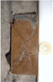
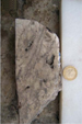
Core and LithofaciesA thorough revision of core and core descriptions in internal reports and in published literature reveals that the central part of the Poza Rica field is dominated by thick packages of rudist rudstone facies, whereas breccia deposits are mostly encountered on the southeast and northeast flanks of the field. There is no evidence that there is any significant increase in interbedding of basinal facies towards the southwest edge of the field; indeed, many wells with almost completely cored sections on the extreme (present) southwest limit have very coarse-grained breccia or rudist rudstone facies with less than 10% of fine-grained basinal sediment. In addition, the wells drilled outside the field limit, in the Coatzintla area to the southwest, are uncored. These wells show broadly similar log stratigraphies as wells within the field and contain porous/permeable intervals, as indicated by porosity and SP logs (Figure 5). One well updip and one well downdip of the seismically-opaque and seismically-elevated facies were selected for core logging (Figure 6). The results of this exercise show conclusively that the updip well is dominated by massive rudist rudstone facies (Figure 7), whereas the well in a downdip position is dominated by massive pebble to cobble grade or coarser breccias, which often consist of reworked rudist framestone (Figure 8). In addition, in the updip well are numerous, irregular erosional surfaces that have been covered in pale gray-green claystone, which can also be seen to infill fissures that descend from the erosional breaks (Figure 7). These surfaces are consistent with interpretation of karstic horizons and karstic fissures.
InterpretationOur interpretation of the above data suggest that early models for the field were largely correct in that they interpreted the central, most productive part of the field as an in situ platform, although these models are still flawed in that they assume chronostratigraphic equivalence of the Poza Rica ‘reefs’ with the Tuxpan Platform. Subsequent models (Viniegra and Castillo, 1970; Enos, 1977, 1985) dismiss the ‘reefal’ model probably because these workers focused on the abundant new data that had just been acquired from the flanks of the field and thus re-interpreted the whole system as a carbonate slope. Our model would suggest that the most productive Tamabra facies both in the Poza Rica field and the Pital y Mozutla field on the flanks of the Tuxpan Platform largely represent second-order shallow-water lowstand platforms passing downdip into slope deposits that were deposited during the Cenomanian-?Turonian when the crest of the Tuxpan Platform (and also most other Mexican ‘middle’ Cretaceous platforms [Smith, 1986; Basáñez et al., 1993]) were subject to subaerial exposure and massive karstification. The cause of this event has recently been suggested by Horbury et al. (2004) as being due to early Laramide uplift of the Gulf continental margin, which in turn was a consequence of Pacific margin subduction which re-commenced in the Aptian (Pindell and Kennen, 2001). We think that the carbonates within the field are dominated by three 3rd-order highstand systems tracts, while the full sequence stratigraphy (highstand, lowstand and transgressive systems tracts) are only complete in the basin between the Poza Rica high and the Tuxpan Platform. Facies in the most productive parts of the high are most closely comparable to grainy, sand-rich rudist margins as known from both the Sierra de El Abra (Griffith et al., 1969; Minero, 1988; 1991), and Cretaceous platform margins in Italy (Carbone and Catenacci, 1978; Eberli et al., 1993; Di Stefano and Ruberti, 2000) and Arabia (Qamchuqa of Kirkuk Field [Wilson, 1975] and the Mishrif of Abu Dhabi [Burchette, 1993]). On the evidence of both core and seismic facies, facies belts at the historically defined southwest margin of the field actually trend SW-NE; in addition, dynamic data (mostly well productivities and present-day production) imply that the productive facies should extend farther towards the southwest. A platform model also much better explains the doline-like features identified on coherency maps as well as the evidence of extensive meteoric diagenesis of the Tamabra reservoir, as presented by Enos (1988). We have found no evidence that the field passes towards the southwest into basinal carbonates; indeed, the likely problem with productivities and Sw (‘water invasion’) towards the southwest may be a consequence of low porosity/microporous platform interior carbonates with high irreducible water (high Sw), just as the center of the Tuxpan Platform is less prospective than its rim (cf., Viniegra and Castillo, 1970). Previous models fail to take into account the very coarse-grained nature of much of the sediment right up to the perceived southwest limit of the field, which lies some 20-25km from the proposed sediment source on the other side of a basin. In addition, previous models fail to give mechanisms for differences in provenance of sediment ‘along strike.’ In reality, a pure slope model is not tenable, although we do recognize many of the breccia facies within the field as being of a slope origin.
Implications and ApplicationsThe correct interpretation of the Poza Rica field is important for ongoing field re-activation because it opens up the possibility of extending the field to the southwest. There are concerns about increased Sw in this direction, but given the fact that the Poza Rica paleohigh (and therefore closure) extends to the southwest, the important issue is finding the ‘sweet spots’ in which rudist rudstone facies are present with their high macroporosity and therefore high permeability and low Sw, compared to high Sw platform interior microporous facies or low-porosity/low-permeability ‘true’ slope breccias. The extent of the rudist rudstone facies belt is at present not well-defined outside of the 3D survey because of the poor quality of the 2D lines towards the southwest. Rudist rudstones are thought most likely to be developed as a donut-shaped body of which only the northeast side has been drilled. Step-out wells targeted at tracking this zone are planned and are thought to be much more likely to add significant reserves than infill wells within the field, or step-out wells situated in updip (platformal) or downdip (slope) settings. There are also implications for exploration models within this and other basins in Mexico. Many breccia fields presently interpreted as slope carbonates may require re-interpretation as in situ lowstand platform, or as karst brecciated platform. Additionally, the Poza Rica field presently stands as the largest example of a slope carbonate field in the world; it and perhaps associated fields awaiting re-examination, therefore, bias the statistical importance of the carbonate slope play system in global terms. Many exploration models have used the field as their principal analog for wildcat wells; therefore re-definition and a better understanding of why the Tamabra play is successful are of paramount importance to global exploration models.
Future WorkThe study was undertaken on a sector of the field in which there are significant lateral changes in both seismic and core facies and in which there were perceived to be opportunities for field extension towards the southwest. Further study is required of seismic, wells, and cores towards the northwest. In the longer term, drilling of step-out wells would be best constrained by extending the 3D coverage towards the southwest.
ReferencesBarnetche, A. and Illing, L.V., 1956, The Tamabra Limestone of the Poza Rica oil field: 20th Congreso Geológico Internacional, México, Monograph, 38p. Basáñez-L., M.A., et al., 1993, Cretaceous platform of Valles-San Luis Potosí, northeastern central Mexico, in Simo, J.A., Scott, R.W., and Masse, J.P. (eds.), Cretaceous Carbonate Platforms: AAPG Memoir 56, p. 51-59. Burchette, T.P., 1993. Mishrif Formation (Cenomanian - Turonian), southern Arabian Gulf: Carbonate platform growth along a cratonic basin margin, in Simo, J.A.T., Scott, R.W., and J- P, Masse, (eds.) Cretaceous carbonates: AAPG Memoir 56, p. 185-200. Carbone, F. and Catenacci, V., 1978, Facies analysis and relationships in Upper Cretaceous carbonate beach sequences (Lepini Mountains, Latium): Geologica Romana, v.17, p. 191-231. Coogan, A.H., et al., 1972, Depositional environments and geological history of Golden Lane and Poza Rica trends, Mexico, an alternative view: AAPG Bulletin, v. 56: 1419-1447. Di Stefano, P., and Ruberti, D., 2000, Cenomanian Rudist-dominated shelf-margin limestones from the Panoramide Carbonate Platform (Sicily, Italy): Facies analysis and sequence stratigraphy: Facies, v.42, p. 24-30. Eberli, G.P., et al., 1993, From aggradation to progradation: The Maiella Platform, Abruzzi, Italy, in Simo, J.A., Scott, R.W., and Masse, J.P. (eds.), Cretaceous Carbonate Platforms: AAPG Memoir 56, p. 213-232. Enos, P., 1977, Tamabra Limestone of the Poza Rica trend, Cretaceous, Mexico, in Cook, H.E., and Enos, P., (eds.)., Deep water carbonate environments: SEPM Special Publication, v. 25, p. 273-314. Enos, P., 1985, Cretaceous debris reservoirs, Poza Rica Field, Veracruz, Mexico, in Roehl, P.O., and Choquette, P.W. (eds.), Carbonate petroleum reservoirs: Springer-Verlag, 28, p. 457-469. Enos, P., 1988, Evolution of pore space in the Poza Rica trend (mid-Cretaceous), Mexico: Sedimentology, v. 35, p. 287-325. Griffith, L.S. et al., 1969, Quantitative environmental analysis of a Lower Cretaceous reef complex, in Friedman, G.M. (ed.), Depositional environments in carboante rocks- a symposium: SEPM, Special Publication no. 14, p.120-138. Gúzman, E.J., 1967, Reef type stratigraphic traps in Mexico: 7th World Petroleum Congress, Proceedings, v.2, p. 461-470. Heritier, F., et al., 1991, Rospo Mare oil-field, Italy: An example of multitechnical appraisal and development, in Spencer, A.M. (ed.), Generation, accumulation and production of Europe’s hydrocarbons: EAPG, Special Publication no. 1, Oxford University Press, Oxford, p. 399-414.. Horbury, A.D., et al., 2004, The western margin of the Gulf of Mexico in the late Mesozoic: less passive than previously imagined, in Bartolini, C., Buffler, R., and Blickwede, J. (eds), The Gulf of Mexico and Caribbean region: Hydrocarbon habitats, basin formation and plate tectonics. Minero, C.J., 1988, Sedimentation and diagenesis along an island-sheltered platform margin, El Abra Formation, Cretaceous of Mexico in James, N.P., and Choquette, P.W.,(eds.), Paleokarst: Springer-Verlag, Berlin and New York. p. 385-405. Minero, C.J., 1991, Sedimentation and diagenesis along open and island-protected windward carbonate platform margins of the Cretaceous El Abra Formation, Mexico. Sedimentary Geology, v. 71, p. 261- 288. Pindell, J.L., and Kennan, L.J, 2001, Kinematic evolution of the Gulf of Mexico and Caribbean, in Petroleum systems of deep-water basins: Proceedings GCSSEPM Foundation 21st Annual Research Conference, p. 193-220. Salas, G.P., 1949, Geology and development of Poza Rica oil field, Veracruz, Mexico: AAPG Bulletin, v. 33, no.8, p.1285-1409. Smith, B.A., 1986, Upper Cretaceous stratigraphy and the mid-Cenomanian unconformity of east-central Mexico: Ph.D. Dissertation, University of Texas, Austin, 190p. Viniegra-O., F., and Castillo-T., C., 1970, Golden Lane fields, Veracruz, Mexico. AAPG Memoir 14, p. 309-325. Wilson, J., L., 1975, Carbonate facies through geologic time: Springer-Verlag. |