![]() Click to view article in PDF format.
Click to view article in PDF format.
Preliminary Geology of Oakdale Field, Northwest Raton Basin, Huerfano County, Colorado*
By
John Worrall1
Search and Discovery Article #20017 (2004)
*Adapted from Transactions, AAPG Southwest Section Convention, Ruidoso, New Mexico, June 6-8, 2002. Special appreciation is extended to John Worrall, Program Chairman for the convention, and to Keith E. McKamey, President, Roswell Geological Society, for making the Transactions available for posting on Search and Discovery.
1Rocky Mountain Gas Supply LLC, Roswell, NM; current address: Worrall Investment Corporation, 215 W. Third, Roswell NM 88201 (tel--505-622-5893).
The purpose of this paper is to document the geology of Oakdale field. This field has four unique characteristics: (1) the field produces from a double-thrusted anticline in a basin that is otherwise not very structurally complex; (2) one of the pay zones is a three hundred-foot-thick igneous rock that has both primary and fracture porosity; (3) the Dakota and Entrada reservoir sandstones have twice as much porosity as typically seen in the Raton basin; and (4) each of the three reservoirs contain a gas of radically different composition, varying from 24% to 97% carbon dioxide and 3% to 75% hydrocarbons.
Production of the field will require significant investment in processing and pipeline facilities. Total reserves for the Dakota and Entrada sandstones are estimated at 450 BCFG in place.
|
uDakota and Entrada reservoirs
uDakota and Entrada reservoirs
uDakota and Entrada reservoirs
uDakota and Entrada reservoirs
uDakota and Entrada reservoirs
uDakota and Entrada reservoirs
uDakota and Entrada reservoirs
uDakota and Entrada reservoirs
uDakota and Entrada reservoirs
uDakota and Entrada reservoirs
uDakota and Entrada reservoirs
|
Oakdale field is located in the northwest comer of the Raton basin, twenty miles west of Walsenburg, in Huerfano County of south-central Colorado (Figure 1). This field was discovered in 1997 and is under development. It is located on approximately 6000 Fee, Federal, and State acres under lease to Rocky Mountain Gas Supply LLC (RMGS), of Roswell, New Mexico. The company is owned by the project investors and managed by John Worrall, Don Fedric and George Scott. Historically, there has been little oil and gas development in the northern Raton basin. Coal mining literally was “king” of Huerfano County during 1895 to 1935 (see “Coal Was King”, Christofferson, 1999). Various mines were operated in and around Oakdale field with miners extracting the Vermejo Formation coals from the surface and then tunneling underground to depths of 400 to 600 feet. The town of Ojo (S/2 Section 4, T29S, R69W) and the town of Oakview, or alternately Oakdale (Sections 9 and 10, T29S, R69W), sprung up around the mines and waxed and waned in the 1910-1930 era before the Ojo and Oakdale fields ultimately closed for good in 1941 and 1954, respectively. At its peak in the 1920s Oakview contained some 800 residents. Now the townsite is largely a cultivated field of hay with little evidence the town ever existed. A guard tower (circa 1913) built with gun turrets, stands on a ridge overlooking the site, as evidence of a turbulent past that included various labor strikes, mine explosions and at least one massacre of mine guards by unhappy striking miners (Christofferson, 1999). Willis Lee and F. H. Knowlton in 1917 in describing these mines were the first to publish evidence of the Oakdale field anticline, as shown in Figure 2. The first commercial gas field in Huerfano County was developed by Arco Oil and Gas, and Exxon USA, who developed the Sheep Mountain carbon dioxide field. This field was developed from five drill pads with twenty-eight wells directionally drilled underneath Sheep Mountain to target a structural anticline buried beneath a laccolith. George Roth (1983) provides a good summary of this field. The Sheep Mountain field produces relatively pure (96 + %) carbon dioxide from the Dakota and Entrada sandstones. The CO2 is trapped in a folded thrust sheet where a gas column of over 1900 feet has been defined. In 1983 Arco and Exxon connected the field to a 408-mile, 20-inch pipeline that transports the carbon dioxide south to the Permian Basin CO2 hub of Denver City, Texas, where the carbon dioxide is used for enhanced oil recovery. The Sheep Mountain field has produced 1.2 trillion cubic feet of carbon dioxide from 1983 to 2002. Current production is 120 MMCFPD down from a peak of 300 MMCFPD in 1988. This field has been the single most important source of tax revenue to Huerfano County during this time. Most recently, the Raton Basin has been experiencing a drilling boom for coalbed methane. Evergreen Resources and El Paso Energy are the most active operators in the play. Hemborg (1998) provides a good summary of this play, which is now producing approximately 100 MMCFGPD. The play has been most successful in the central and southern portions of the Raton Basin, in Las Animas County, Colorado and Colfax County, New Mexico. Production comes from depths of 800 to 3000 feet from multiple coal seams in the Cretaceous Raton and Vermejo formations. To date no commercial CBM reserves have been produced in Huerfano Country, which lies north of the Spanish Peaks in the northernmost portion of the basin. Approximately 60 coalbed methane exploration wells have been drilled in Huerfano County since 1996 by Petroglyph Operating, the J. M. Huber Corporation, and Cedar Ridge L.L.C., but to date these operators have not started producing commercial quantities of gas. The projects are still being de-watered. This article documents the presence of a new sizable accumulation of carbon dioxide and hydrocarbons in Huerfano County beneath the “Oakdale” anticline, which is recognized by the Colorado Oil and Gas Commission as Oakdale field. Like Sheep Mountain field, Oakdale field’s main Dakota and Entrada sandstone reservoirs produce from a folded thrust sheet.
In our current understanding, Oakdale field is believed to encompass parts of Sections 32-34, T28S, R69W, and Sections 3-5, 9-10, and 15-16, T29S, R69W. Over the crest of the anticline. NW-SE-striking, dark gray shales of the Pierre shale are exposed at the surface, as recognized by Lee and Knowlton (1917), Johnson and Stephens (1959), and Vine (1974), among others. The axis of the Ojo syncline. present to the west (Figure 2), contains the Tertiary Poison Canyon sandstones, successively underlain by the coal-bearing Cretaceous Vermejo Formation, Cretaceous Trinidad Sandstone, and the Cretaceous Pierre Shale. NW-SE striking Tertiary dikes form vertical walls, with over 100 feet of relief in Sections 33 and 34, T28S, R69W. These dikes are composed of a hornblende porphyry containing distinctive large black phenocrysts of hornblende up to 20 cm in size within a medium gray ground mass. The dikes are believed to have the same composition as Silver Mountain three miles to the north. The NW corner of Oakdale field abuts Mount Maestas, which rises to an elevation of over 11,500 feet. It is composed of a microcrystalline rock of granitic composition that is termed a felsite (Vine, 1974). Vine has interpreted Mount Maestas to have the geometry of a pluton or stock, while Roth (1983) interprets Mount Maestas as a laccolith. Limited seismic data available to RMGS along the SE side of Mount Maestas show no continuous subsurface reflection below the top of the buried felsite, which appears to support a stock or pluton geometry. This is the interpretation presented herein. Figure 3 shows the stratigraphic column of the Raton Basin. There have been numerous reviews of the stratigraphy of the Raton basin, including among others Lee and Knowlton (1917), Johnson and Wood (1956), Johnson et al. (1966), Stevens et al. (1992), Tyler et al. (1995), and Hemborg (1998). In the absence of complicating factors, such as multiple igneous dikes and sills and repeated sections due to at least two episodes of thrust faulting, the stratigraphy of this area is fairly easy to understand and the beds have reasonably consistent thicknesses. The anticlinal axis is expressed at the surface by dark gray shale of the Cretaceous Pierre Formation. It is underlain by Cretaceous shale of the Niobrara Group, which is essentially indistinguishable from the Pierre during drilling. The entire Pierre and Niobrara are 2700 feet thick, as determined in wells drilled east of the folded thrust belt, where the section is flat or relatively flat. The lowermost part of the Niobrara Group is marked by a 30-foot-thick limestone, known as the Fort Hayes Limestone. During drilling, this marker bed is very helpful to determine structure. This marker bed generally reflects the structure of the underlying Dakota and Entrada sandstone reservoirs. Between the Fort Hayes Limestone and Dakota Sandstone are rocks of the Benton Group--the Codell Sandstone, Carlile Shale, Greenhorn Limestone, and Graneros Shale, totaling approximately 600 feet. The underlying Cretaceous Dakota Sandstone is 200 feet thick; the Jurassic Morrison shales are 350 feet thick; and the basal objective Jurassic, Entrada Sandstone, is 60 feet thick. In summary, the true thickness of the interval between the top of the Pierre Shale and the top of the Dakota Sandstone is approximately 3300 feet.
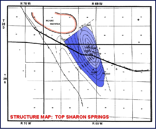
Igneous Felsite “Sill” Reservoir RockDue to both thrust faulting and emplacement of multiple dikes and sills, the actual section encountered is more complex. For instance, the discovery well of Oakdale field, Harry Willis #l (SE/4 NE/4 Section 4, T29S, R69W), spudded in the Pierre Shale and did not penetrate the top of Dakota Sandstone until 5248 feet below surface (+ 2714). Subsequent well control and seismic data show that the extra penetration of 2000 feet is due to a shallow thrust located over the main productive thrust sheet, as set forth in Figure 4. During drilling, the shales of the Pierre and Niobrara all look the same: fresh water sensitive, dark gray shales. However, log data at 2146-2166 feet in Harry Willis #l indicate the presence of a radioactive bentonite that actually can be correlated from well to well in the shallow thrust sheet. This marker, which we call the “Sharon Springs bentonite,” provides a structural datum within this thick interval and shows structural relief from the top of the anticline to the synclinal low of 2170 feet (Figure 5). Just above the bentonite marker (1770 to 2080 feet in Harry Willis #1) is a 310-foot-thick white to light gray aphinitic rock. Thin-section, SEM, and core data show this rock is a white felsite of the same composition (microcrystalline granite) as Mount Maestas. Notably the well contains matrix porosity of up to 14.8% and permeability of 0.l to 0.5 millidarcys (sidewall core data, Table 1). A formation micro-imaging log shows that the 310-foot interval contains 412 open fractures with fracture apertures ranging from 80 to 200 micrometers (.08 to .2 mm). By comparison, matrix pore diameters are typically 1 to 10 micrometers; so clearly, fractures enhance porosity and permeability. The FMI log shows that the fractures primarily strike N20W, parallel to the axis of the surface anticline and dip most commonly 50 to 75 degrees to the east, with some dipping west. The felsite is entirely encased in the dark gray shales of the Pierre Formation. The felsite appears to have been emplaced as a magmatic fluid intruded at or near the bentonite marker. In some cases, it is present above the bentonite marker; in other cases, it is below. The felsite may have originally intruded along a shallow thrust plane also seen on seismic data. A complicating factor is that it is not always clear from sparse well control whether the felsite that may be present in one well was emplaced the same time as a felsite body in another well. In four of the six wells where it has been encountered, it has been tested gas productive. In one well good hydrocarbon shows were observed and the sixth well was not evaluated. Where tested, the felsite has produced primarily methane with 20 to 25% carbon dioxide (Table 2). A drillstem test in Harry Willis # 1 yielded 280 MCFGPD from the upper felsite, with an 1’30” ISIP of 663#. and a 2’ FSIP of 679#. A maximum flow rate of 1400 MCFGPD was reported for Kimbark Operating Stauder #l (SW NE Section 4, T29S, R69W). Currently, two wells, Harry Willis #7-4 and #2-4 (NE/4 Section 4, T29S, R690W) are completed in the felsite zone as shut-in gas wells, pending the emplacement of a pipeline. At least two other igneous bodies have been encountered. One hundred feet of hornblende porphyry dike was encountered in the interval between the Fort Hayes and Dakota in Harry Willis #l. This dike is expressed at the surface in Section 33, T29S, R69W. Secondly, rock of felsite composition was found in this same interval in White et al. #l (NE/4 Section 9, T29S, R69W). The igneous rock added to the interval of the section rather than replaced country rock. The base of the felsite is only 30 feet above the top of the Dakota in White et al. #l. This well does show an upward decrease in Dakota porosity, likely the result of felsite fluids partially cementing the upper Dakota Sandstone (Section 28, T28S, R69W).
Enhanced Dakota and Entrada Porosity in the Folded Thrust Sheet In Harry Willis #1, log data show the Dakota Sandstone has crossplot porosity of typically 16- 20%. Core data show the Dakota sandstones with up to 17.2% (Table 1) porosity and up to 126 millidarcys of permeability. By comparison this is roughly twice the porosity typically (6 to 10%) seen in wells penetrating the Dakota in the northern Raton basin. The Dakota porosity at Oakdale field is more typical of the Dakota porosity observed at the Sheep Mountain field, (also 16-20%). Kam Chiang, the Denver-based geologist that originated this prospect, believes that the Dakota in the folded thrusted sheet contains enhanced porosity because it is not subject to silicification related to groundwater recharge. In all other areas of the Raton basin, the Dakota (and Entrada) sandstones are present around the circumference of the basin, with recharge primarily occurring on the west side, flowing east into the basin. Due to the multiple thrusts, the Dakota does not crop out on the west side of the thrust, and recharge, therefore, does not occur. An exception to the presence of good porosity in the Dakota Sandstone can be found on the northwest side of Oakdale field, where Arco drilled Arco #2-28 (Section 28, T28S, R69W) and Arco #6-32 (Section 32 , T28S, R69W). These wells are believed to be located within 1000 feet of the subsurface expression of the Mount Maestas stock. It is interpreted that porosity has been significantly reduced (to 6 to 12% crossplot) by related magmatic fluids in an aureole around Mount Maestas. The Entrada sandstone also shows 16 to 20% cross plot porosity, with core data showing up to 20-21% porosity and 29 millidarcys. Both the Dakota and Entrada porosity show up to 12% crossover between the density and neutron logs (limestone matrix) in Oakdale field wells, clearly indicating gas affect. StructureThe sedimentary sequence present was folded and thrusted contemporaneously with the emplacement of the felsite sill and the Mount Maestas felsite stock. The thrusting and folding that formed Oakdale field is believed to have occurred during Paleocene to Oligocene time, during the Laramide orogeny that formed the Sangre de Cristo Mountains, approximately 45 to 60 million years ago. At least two episodes of thrust faulting are recognized (Figure 4). Evidence for a shallow thrust in the Pierre is based on (1) the extra 2000 feet of shale encountered, (2) seismic data, and (3) different structural relief within the shallow thrust than that present at the Dakota level in the main thrust sheet. Structural relief from the crest of the anticline to the synclinal low is 2137 feet at the bentonite marker bed (Figure 5) in the shallow thrust sheet. This relief is approximately 1400 feet in the main thrust sheet at the top of the Fort Hays Limestone, Dakota Sandstone, and the Entrada Sandstone (Figures 6, 7, and 8). The folded thrust belt is the area between the eastern and western thrust faults shown on Figure 7, the Dakota structure map. The westernmost thrust is the leading edge of the Sangre de Cristo Mountains that brings Pennsylvanian Sangre de Cristo Formation red beds next to the Cretaceous section typical of the Raton basin. The second main thrust bounds the Oakdale anticline on the east. The easternmost thrust bounds an untested deeper fault block. East of this last thrust fault is the relatively undisturbed section of the Raton basin. Within the folded thrust belt also are several more minor faults detected by seismic data shown on the map.
Analysis and Test InformationAs further discussed below, Table 2 shows the varying composition of the produced gas from the felsite sill, the Dakota Sandstone, and the Entrada Sandstone. The felsite sill has produced with an instantaneous rate as high as 1400 MCFPD (CAOF 365 MCFGPD) in testing of Kimbark Stauder #2, SW NE Section 4, T29S, R69W. This well showed the felsite primarily contains hydrocarbons (73.9%), with CO2 (24.7%). and nitrogen (1.4%). Testing of three other felsite wells, Harry Willis #2-4, #7-4, and #l, all located in the NE/4 of Section 4, T29S, R69W, have shown similar compositions across a structural elevation of over 400 feet (+6192 to +5721 feet for the top of the sill). Significantly, a downdip well, White et al. also encountered significant mudlog gas shows in a 270-foot-thick felsite, with a top of +3834 feet, over a mile to the SW of these wells. No water has been observed to date in this reservoir. The two shut-in wells, Harry Willis #2-4 and #7-4, appear capable of producing from the felsite at a rate of 250 to 500 MCFGPD per well. Test data shows the Dakota Sandstone contains 70 to 74% CO2, 25 to 29% hydrocarbons, and 1% nitrogen (Table 2). The structurally highest well, Harry Willis #l, encountered the Dakota at +2714 feet and tested 28.90% hydrocarbons, with a hexane plus heavy component of 0.1%. This well was tested through 2 7/8” tubing and flowed 3.4 MMCFPD from the lower Dakota. A test of the upper Dakota flowed 6.2 MMCFPD, but the test was restricted by the size of the tubing. By lining the well with 5 ½-inch polybore plastic, RMGS hopes to combine the upper and lower Dakota perfs to produce a minimum of 9.4 MMCFPD and hopefully significantly more. For example, the Sheep Mountain field was completed in 1983 with thirteen Dakota wells that produced at an average rate of 18 MMCFPD up 4 ½-inch tubing. Most of these wells have produced in excess of 70 BCF per well. The second highest well, the White et al. tested 25.2% hydrocarbons with a hexane plus heavy content of 0.9%. This well encountered the Dakota at +2092 feet, 622 feet low to Harry Willis #l. The relatively minor change in composition across 622 feet of structure suggests the Dakota Sandstone will contain a gas composition that could be approximated by the average composition in these two wells. The highest water tested in the Dakota is established by Arco #6-32, which encountered the Dakota at +1564 TVD. The lowest known gas is established in Arco fee #l at a TVD of +1827 feet. For estimates of reserves, RMGS has assumed a gas/water contact of +1750 feet (Figure 7). RMGS calculates potential reserves of 377 BCFG in place across a gas column of approximately 1000 feet. These reserves include 287 BCFG in the main thrust sheet covering 3416 acres, with a potential 90 BCFG in the Dakota in an untested subthrust sheet west of the syncline. The main anticline is believed to contain recoverable reserves of 165 BCF of CO2 and 61 BCF of hydrocarbons. Through 2 7/8-inch tubing, the Entrada tested 5.9 MMCFPD of pipeline pure 97% CO2 in the discovery well. The flow test was tubing restricted, and RMGS hopes to produce at a higher rate up 5 l/2-inch polybore-lined casing. By example, Arco tested the initial Sheep Mountain Entrada wells at an average rate of 9 MMCFPD, with a range of 5 to 16 MMPD, up 4 ½-inch tubing. RMGS believes the gas-water contact for the Entrada is approximately at +1750 feet and that the Entrada Sandstone in the main thrust sheet contains 64 BCF of recoverable CO2.
Development PlansPending the success of three planned wells in the summer of 2002, RMGS has contracted for the construction of a processing facility to process 40 MMCFPD of Dakota gas over fifteen years into 29 MMCFPD CO2, 616 barrels per day of natural gas liquids, and 9810 MCFGPD with a 1017 MBTU content. Both the plant and a natural gas pipeline have been permitted. Hopefully, a future update of this article will document the success of this venture.
ReferencesChristofferson. Nancy, 1999, When Coal Was King: Huerfano County’s Mining History, 114 p. Hemborg, H. Thomas, 1998, Spanish Peak field, Las Animas County, Colorado: Geologic setting and early development of a coalbed methane reservoir in the central Raton basin: Colorado Geological Survey, Department of Natural Resources, Resources Series 33. Johnson, R.B., G.H. Dixon and A.A. Wanek, 1966. Late Cretaceous and Tertiary stratigraphy of the Raton basin of New Mexico and Colorado, in New Mexico Geological Society Seventeenth Field Conference Guidebook, Taos-Raton-Spanish Peaks Country, p. 88-98. Johnson. R.B., and J.G. Stephens, 1954, Surface map. Geology of the La Veta area, Huerfano County, Colorado: U.S.G.S. Oil and Gas Inv. Map OM-146. Johnson, R.B., and G.H. Wood, 1956, Stratigraphy of Upper Cretacceous and Tetiary rocks of Raton basin, Colorado and New Mexico: AAPG Bulletin, v. 40, no. 4, p. 707-721. Lee, W.T., and F.H. Knowlton, 1917, Geology of the Raton Mesa and other regions in Colorado and New Mexico: U.S.G.S. Professional Paper 101, 221 p. Roth, George, 1983, Sheep Mountain and Dike Mountain fields, Huerfano County, Colorado: A source of CO2 for enhanced oil recovery, in Four Corners Geological Society Oil and Gas fields of the Four Corners area, Volume III, p. 740-744. Stevens. S.H. T.E. Lombardi, B.S. Kelso, and J.M. Coates, 1992, A geologic assessment of natural gas from coal seams in the Raton and Vermejo formations, Raton basin: Advanced Resources International, Inc., topical report prepared for the Gas Research Institute under contract no. 5091-214-23 16, GRI 92/0345, 84 p. Tremain, C. M., 1980, The coalbed methane potential of the Raton Mesa coal region, Raton basin, Colorado: Colorado Geological Survey Open-file report 80-4, 48 p.. Tyler, Roger, W.R. Kaiser, A.R. Scott, D.S. Hamilton, and W.A. Ambrose, 1995, Geologic and hydrologic assessment of natural gas from coal: Greater Green River, Piceance, Powder River and Raton Basins, Western United States: University of Texas Bureau of Economic Geology Report of Investigations no. 228, 219 p. Vine. James D. 1974. Geologic map and cross sections of the La Veta Pass, La Veta, and Ritter Arroyo quadrangles, Huerfano and Costilla counties, Colorado: U.S.G.S., Map l-833.
AcknowledgmentsThis paper benefited from numerous discussions and reports over the last five years from George L. Scott. Jr., geologist, Kam Chiang, prospect originating geologist, Bruce Stubbs, reservoir engineer, and Wally Rashall. plant engineer. |


