--> Tropical versus Temperate Zone Lacustrine Source Rocks: Examples from Takutu Basin, Guyana, and General Levalle Basin, Argentina, by Robert E. Webster, #10070 (2004).

Datapages, Inc.Print this page

Click to view poster presentation in PDF format.

        Poster 1       Poster 2        Poster 3        Poster 4


Tropical versus Temperate Zone Lacustrine Source Rocks: Examples from Takutu Basin, Guyana, and General Levalle Basin, Argentina

by

Robert E. Webster1


Search and Discovery Article #10070 (2004)


*Adapted from a poster presentation at AAPG Annual Convention, Dallas, Texas, April 18-21, 2004. 

1Hunt Oil Company, Dallas, Texas ([email protected])


Abstract 

Rift basin lacustrine source rocks have generated 5.7 percent of the world’s reserves, and some of today’s most active exploration plays are driven by lacustrine-shale-based petroleum systems. However, paleolatitude and paleoclimate play major roles in determining organic richness of lake sediments, and not all restricted lacustrine basins contain commercial petroleum systems. Two continental-interior lacustrine rift basins in South America display dramatic differences.  

In the Takutu basin, at a tropical paleolatitude of 2°N, deposition in an Early to Middle Jurassic rift during global “hothouse” conditions produced organic-rich shale with 1.5 to over 4% TOC, hydrogen indices of over 360, and pyrolysis yields up to 9300 ppm. Terrestrial kerogen is significant, but Type I/II non-marine algal amorphous kerogen is dominant in richer intervals. Significant oil and gas were generated but mostly lost during Miocene(?) tectonic reactivation. 

In contrast, the Lower Cretaceous General Levalle rift basin formed at a temperate zone paleolatitude of 45°S during mild “icehouse” climatic conditions. Dark lacustrine shale is organic-lean, with maximum TOC just over 1%. Kerogen is Type III/IV, derived mostly from pollen from nearby upland forests, with little generative capacity. Here the annual seasonal cycle probably caused lake turnover and prevented long-term establishment of an anoxic bottom layer to preserve organic matter, which is common in more tropical settings such as the Takutu.


uAbstract

uIntroduction

  uFigures 1.1-1.4

  uPurpose of presentation

  uGlobal considerations

  uSummary of two basins

    uGeneral Levalle Basin

    uTakutu Basin

uGeneral Levalle Basin

  uFigures 2.1-2.12

  uGeneral setting

  uPaleogeography & climate

  uGeochemistry

uTakutu Basin

  uFigures 3.1-3.13

  uGeneral setting

  uPaleogeography & climate

  uGeochemistry

uConclusions

uReferences


Introduction

Figure Captions (1.1-1.4)

Return to top.

Purpose of Article/Poster Presentation 

  • Review depositional environments and source rock characteristics of two geologically-similar South American Mesozoic rift basins that formed at differentpaleolatitudes under different climates.

  • Compare tropical vs temperate settings.

  • Goal: Increase awareness of source risk associated with exploration for lacustrine-sourced basins.


Global Considerations: Lacustrine Source Rocks 

  • Most South American and African Atlantic margin petroleum plays are sourced by Lower Cretaceous lacustrine source rock.

  • Most organic-rich lacustrine source rocks were deposited in tropical to sub-tropical settings.

  • Annual lake turnover associated with the freeze/thaw cycle tends to limit preservation of organic material in lake bottom sediment.


The depositional model for a restricted lacustrine basin is shown in Figure 1.1. This representation is for the General Levalle basin of Argentina.


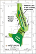
Summary of Features of Two South American Basins  

The locations of the General Levalle Basin in Argentina and the Takutu Basin in Guyana/Brazil are given in Figure 1.2. Major features of each are summarized below.


     Features of General Levalle Basin, Argentina (Figure 1.3) 

  • Type- Intracratonic rift basin

  • Age- Early Cretaceous

  • Paleolatitude- 45°South

  • Size- 150 km long, 5-50 km wide, and over 6.5 km deep

  • Area- >5000 sq.km.

  • Sedimentary Fill- Early coarse siliciclastic fill fines upward to an evaporite phase, then coarsens upward again into siltstones and sandstone, capped by basalt flows.

  • Structural reactivation- none.


     Features of Takutu Basin, Guyana and Brazil (Figure 1.4) 

  • Type- Intracratonic rift basin

  • Age- Early Jurassic to Early Cretaceous

  • Paleolatitude- 2°North

  • Size- 280 km long, 40 km wide, and over 7 km deep

  • Area- >11,200 sq. km.

  • Sedimentary Fill- Early basaltic phase followed by lacustrine and basin margin clastics, an evaporite phase, and final siliciclastic fill.

  • Structural reactivation: Miocene.


General Levalle Basin, Argentina 

Figure Captions (2.1-2.12)

Figure 2.1. Basin outline map, General Levalle Basin, with major structural elements on seismic base map.

Figure 2.2. Stratigraphic section, Hunt Cd. GL x-1, General Levalle Basin, Argentina. Note poor relationship of reservoir to seal and source.

Figure 2.3. East-West seismic line 91-08 and cross-section, showing local structure as well as general configuration of the basin.

Figure 2.4. Time structure map of prospect, on orange reflector (lower gypsiferous siltstone, General Levalle Formation).

Figure 2.5. Seismic line ARH-91-32 across General Levalle structure.

Figure 2.6. Late Cretaceous paleogeography (94 Ma). (Image from Christopher Scotese, The Paleomap Project, http://www.scotese.com/cretaceo.htm, and presented here with the kind permission of Dr. Scotese.)

Figure 2.7. Early Cretaceous paleogeography--125-115 Ma (above) and 130 Ma (below). (Image from Ron Blakey, Northern Arizona University, http://jan.ucc.nau.edu/~rcb7/Cret.jpg, and presented here with the kind permission of Dr. Blakey.)

Figure 2.8. Global reconstruction to show Berriasian (Early Cretaceous [140 Ma]) paleogeography, showing General Levalle Basin at 45o latitude. (Image from Robertson Research, Phanerozoic Paleogeographic Reconstructions and Major Source Rocks of the World, and presented here with the kind permission of Robertson Research.)

Figure 2.9. Early Cretaceous climate, with temperature indicators presented on a global paleogeographic map, along with plot of temperature through geologic time (Images from Christopher Scotese, The Paleomap Project, http://www.scotese.com/ecretcli.htm, and presented with kind permission of Dr. Scotese.)

Figure 2.10. Source and maturity data from Hunt Cd. GL x-1 well.

Figure 2.11. Van Krevelen diagram, showing kerogen to be Type III/IV in Hunt Cd. GL x-1 well.

Figure 2.12. Cross-section along seismic line 91-8, showing location of Hunt Cd. GL x-1 and the stratigraphic section it penetrated (part of Figure 2.3).  


Geologic Setting (Figures 2.1-2.5)

The General Levalle Basin forms a long, narrow, and deep Lower Cretaceous intracratonic rift in southern Cordoba province, Argentina. As a buried Lower Cretaceous rift, it trends approximately north-south for over 150 km, ranges from 5 to 50 km in width, and is over 6500 m deep (Figure 2.1). Below a prominent mid-Cretaceous unconformity, steeply dipping normal faults bound tilted graben and half-graben fault blocks (Figure 2.3).  

The lower rift-fill section, the General Levalle Formation (Figure 2.2), is a Valanginian-Hauterivian-aged clastic-evaporite package, over 3200 m thick. It was deposited in an arid, restricted, rift basin that included a hydrologically-closed saline lake. Nine lithology-based members represent one continuous cycle of deposition, with a lower coarse clastic sequence gradually fining upward into an evaporite member and then coarsening upward again into an upper sandstone. The uppermost rift fill sequence, the Guardia Vieja Formation, is a series of Aptian basalt flows and sills over 800 m thick with some clastic interbeds. Unstructured Pleistocene to Upper Cretaceous strata overlie the buried rift basin. 

In 1995-96, the first exploratory well in the basin (Figures 2.4 and 2.5) tested a deep-seated anticline to 5179 m but encountered just one minor show. Reservoir-quality sandstone occurs only in the upper rift sandstone member, but this lacked adequate seals. Basin-center dark shale below the evaporite member was thin, surprisingly low in TOC, and overmature. Given the narrow, deep depocenter, unfavorable reservoir-seal relationships, and the lack of source facies, an effective petroleum system remains unproven in the basin.


Paleogeography and Climate: Different Perspectives

Late Cretaceous paleogeography, portrayed by Christopher Scotese (Figure 2.6) shows the extent of the Tethys Ocean and the expanding Atlantic Ocean. Interpretations of Early Cretaceous paleogeography are shown in Figure 2.7, from Ron Blakey, and in Figure 2.8, from Robertson Research. They both show General Levalle Basin to be intracontinental.

Mild “ice house” conditions existed in southern Gondwana in the Early Cretaceous, probably with snow and ice during the winter season, as shown in Figure 2.9, from Christopher Scotese.


Source Rock Geochemistry  

Analysis of data and tests from Hunt Cd. GL x-1 well indicate that the petroleum system in General Levalle Basin is poor. A summary of the results is given in Figures 2.10 and 2.11, and the drilling results are illustrated in Figure 2.12. The drilling results of Hunt Cd. GL x-1 are listed below:

·        Lower Cretacous (Neocomian) rift fill.

·        Poor source rock found: Lean Type III/IV.

·        Lower rift shales overmature for oil.

·        Only 1 minor oil show.

·        Good evaporite seal in middle rift section.

·        Reservoirs below seal tightly cemented.


Takutu Basin, Guyana and Brazil 

Figure Captions (3.1-3.13) 

Figure 3.1 Major basin elements and leads, Takutu Basin, Guyana.

Figure 3.2 Stratigraphic column of Takutu Basin, graphically showing reservoir, source, and seal potentials of the various units.

Figure 3.3. Structural cross-section, Takutu Basin, along with elements of the petroleum system (from Crawford et al., 1985). Reservoirs: fractured basalt and alluvial sands(?); seals: Pirara salt and mudstone; source: Manari and Pirara formations.

Figure 3.4. Time structure map, on Apoteri Basalt, Takutu Basin.

Figure 3.5. Seismic line 79-7, along Savannah Arch, showing two prospects.

Figure 3.6. Early Jurassic paleogeography (195 Ma), showing location of Takutu Basin within the continent and paleolatitude of 2oN. (Image from Christopher Scotese, The Paleomap Project, http://www.scotese.com/jurassic.htm, and presented here with the kind permission of Dr. Scotese.)

Figure 3.7. Early Jurassic paleogeography, with location of Takutu Basin, 205-195 Ma (above) and 200 Ma (below). (Images from Ron Blakey, Northern Arizona University, http://jan.ucc.nau.edu/~rcb7/Jur.jpg, and presented here with kind permission of Dr. Blakey.)

Figure 3.8. Early Jurassic (Toarcian—109 Ma) paleogeography, showing location of Takutu Basin. (Image from Robertson Research, Phanerozoic Paleogeographic Reconstructions and Major Source Rocks of the World, and presented with kind permission of Robertson Research.)

Figure 3.9. Early Jurassic climate, with temperature indicators presented on a global paleogeographic map, along with plot of temperature through geologic time. (Images from Christopher Scotese, The Paleomap Project, http://www.scotese.com/ejurclim.htm, and presented here with kind permission of Dr. Scotese.

Figure 3.10. Plot of TOC (%) vs. depth of data from 4 wells in Takutu Basin.

Figure 3.11. Van Krevelen diagram for data from 4 wells in Takutu Basin.

Figure 3.12. Maturation profiles (vitrinite reflectance vs. depth) for 4 wells in Takutu Basin. There are two apparent trends in Turantsink 1.

Figure 3.13. Seismic line 91-20, showing position of Turantsink 1, with post-drill interpretation.


General Setting 

The Takutu basin is an ENE-trending Jurassic-Early Cretaceous continental (lacustrine) rift basin, about 40 km wide and 280 km long, that cuts the Guyana shield in southwest Guyana and northern Brazil (Figure 3.1). Prior exploration documented a stratigraphic section dominated by mudstone but including Jurassic lacustrine source shale, siltstone, evaporites, and basalt (Figure 3.2). Numerous anticlinal and tilted fault block structures, including a noncommercial oil discovery (Figure 3.3), suggested an attractive exploration play existed. 

In late 1988 Hunt Oil Co. began operations in the basin. A three-year exploration program included field geology, photogeologic mapping, several methods of surface geochemical prospecting, reprocessing, and acquisition of SAR, aeromagnetics, and 1331 km of new seismic. Exploration efforts ultimately focused on the large basin-center Savannah Arch(Figures 3.3, 3.4, and 3.5). An anticline near the south end, where the exploration well, Turantsink 1 (Figure 3.5), was drilled, was interpreted as a drape feature above a thick lacustrine-fan-delta complex. However, the deep structure proved rooted in a thickened salt section near the Jurassic basin paleocenter.  

Minor oil shows were observed at several horizons, but the predicted sandstone reservoirs are not present. This part of the basin had been affected by a Tertiary hydrothermal event that drove the thick source shales into overmaturity and destroyed porosity in all potential reservoir units. This event plus unfortunate timing of Late Tertiary (Miocene) structural reactivation severely downgrade the petroleum potential of the basin.


Paleogeography and Climate: Different Perspectives 

Early Jurassic paleogeography, portrayed by Christopher Scotese (Figure 3.6), shows the location of Takutu Basin. Interpretations of Early Jurassic  paleogeography are shown in Figure 3.7, from Ron Blakey, and in Figure 3.8, from Robertson Research. These maps all show Takutu Basin to be intracontinental. The climate in the interior of Pangea, including the Takutu Basin area, was very hot and arid during source-rock deposition in Early to Mid Jurassic time (Figure 3.9).


Source-Bed Geochemistry

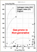
Reduced TOC levels in two Takutu Basin wells (Turantsink 1 and Lethem 1) are due, at least in part, to over-maturation (gas window) of lacustrine shale source rocks of the Pirara and Manari formations (Figure 3.10). Type I/II kerogen is evident in early mature to mature Karanambo and Lethem samples (Figure 3.11). Low HI numbers inTurantsink 1 are due to overmaturity of the source interval. Overmaturity (Figure 3.12) and degradation of rich oil-prone lacustrine shale was caused by intense Miocene hydrothermal activity along south graben boundary faults.


The post-drill interpretation, based on the Turantsink 1 (Figure 3.13), is that the petroleum system was destroyed; this is based on the following: 

  • Turtle structure: salt withdrawal along south boundary fault.

  • Porosity destroyed by cementation/mineralization.

  • Intense hydrothermal activity along south fault.

  • Source very overmature.

  • No live oil or gas shows, trace residual oil.


Conclusions 

  • Takutu basin formed in the Jurassic, related to opening of the southern North Atlantic Ocean.

  • General Levalle basin formed later, in the Early Cretaceous, related to opening of the southern South Atlantic Ocean.

  • Both basins were continental-interior rifts, cut-off from the sea, but with long-lived hypersaline lakes and similar sedimentary fill.

  • Takutu sedimentation took place in a tropical paleolatitude at a time of global “hothouse” conditions.

  • Stable tropical climate minimized lake turnover and promoted anoxic lake bottom conditions. Oil-prone source rock, containing algal/ amorphous kerogen, was deposited and preserved.

  • General Levalle sedimentation took place at a temperate paleolatitude during mild global “icehouse” conditions.

  • Seasonal lake turnover apparently prevented accumulation and preservation of rich source rock facies.

  • Only lean Type III/IV kerogen was deposited and preserved, with little petroleum potential.


References 

Blakey, Ron, 2004, Paleogeography through Geologic Time (http://jan.ucc.nau.edu/~rcb7/global_history.html): Northern Arizona University.

Crawford, F.D., C.E. Szelewski, and G.D. Alvey, 1985, Geology and exploration in the Takutu graben of Guyana and Brazil: Journal Petroleum Geology, v. 8, p. 5-36.

Robertson Research, Phanerozoic Paleogeographic Reconstructions and Major Source Rocks of the World.

Scotese, Christopher, 2004, The Paleomap Project (http://www.scotese.com).

Return to top.