Tectonic Control on the Creation of Supergiant Fields in the Central and South Caspian Area*
Steve Hall and Vanessa Sturrock, BP
Search and Discovery Article #10015 (2001)
*Adapted for online presentation from article of same title by same authors in The Bulletin, Houston Geological Society, January, 2001 (v. 43, no. 5), p, 12-15, 17. Appreciation is expressed to Houston Geological Society, especially Chuck Sharpe, Editor, and to Steve Hall for their permission to present this online version. Steve Hall also provided images in digital format. HGS website is www.hgs.org.
The tectonic history of the Caspian played a major role not only in creating traps but also in creating depositional environments during which excellent quality reservoir and source rocks were deposited. These events resulted in the development of the giant fields in the North and South Caspian basins today.
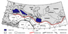 Figure 1.
Main
tectonic elements in the Caspian area. Al =Alborz Mountains, A= Arabian Plate,
BM = Bitlis Massif, EAAC = East Anatolian Accretionary Complex, EP = East
Pontides, F = Farah Block, H = Helmond Block, I = Indian Plate, I-Z =Istanbul
Zonguldak zone, K = Kirsejhir, L = Lut Block, M = Moesia, M-T = Menderes Taurus
Block, NT = North Transcaucasus, NWI = Northwest Iran, S = Sakarya, ST = South
Transcaucasus, S-S = Sanandaj-Sirjan Zone.
Figure 1.
Main
tectonic elements in the Caspian area. Al =Alborz Mountains, A= Arabian Plate,
BM = Bitlis Massif, EAAC = East Anatolian Accretionary Complex, EP = East
Pontides, F = Farah Block, H = Helmond Block, I = Indian Plate, I-Z =Istanbul
Zonguldak zone, K = Kirsejhir, L = Lut Block, M = Moesia, M-T = Menderes Taurus
Block, NT = North Transcaucasus, NWI = Northwest Iran, S = Sakarya, ST = South
Transcaucasus, S-S = Sanandaj-Sirjan Zone.
 Figure 2.
Present-day
position of the Mesozoic-Cenozoic sutures.
Figure 2.
Present-day
position of the Mesozoic-Cenozoic sutures.
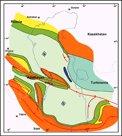
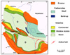 Figure 3.
Main
source rock paleogeography: Early (lower) Maykop Formation (Oligocene – early
Miocene in age).
Figure 3.
Main
source rock paleogeography: Early (lower) Maykop Formation (Oligocene – early
Miocene in age).
Click here for sequence of Figures 3 and 4.
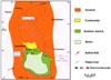 Figure
4. Main
reservoir paleogeography: the Pereriv Suite of the Azerbaijan Productive Series
(latest Miocene – early Pliocene in age).
Figure
4. Main
reservoir paleogeography: the Pereriv Suite of the Azerbaijan Productive Series
(latest Miocene – early Pliocene in age).
Click here for sequence of Figures 3 and 4.
Over 2000 oil and gas fields have been discovered in the area between the Black Sea and Turkmenia (Figure 1) in the former Soviet Union. Of particular note are the supergiant fields of the Caspian area; such as, Kashagan and Tenghiz in the North Caspian and Shah Deniz and Chirag fields in the South Caspian (Figure 2). This note describes the late Permian to present day structural evolution and tectonic setting of these fields and the influence the tectonic events have had on the hydrocarbon story. This regional story was completed in 1993 at BP as support for the application for acreage in the Caspian basin.
The Caspian Sea can be considered three discrete basins (Figure 2) with completely different origins. The North Caspian area is underlain by a Paleozoic passive margin. The Central Caspian is a foreland basin associated with shortening of the Caucasus Mountains and the southern area developed as a pull-apart basin during the Mesozoic. The basins all formed within crust that originated from the supercontinent Laurasia, which accumulated during the Paleozoic (Sengor et al., 1993). The southern boundary of the South Caspian basin is interpreted to represent the suture that separates Laurasia from the fragments of the Gondwana supercontinent (Iran) that accumulated during the Mesozoic and Cenozoic (Figure 1). This paper concentrates on the post-Paleozoic evolution of the Caspian.
The North Caspian basin is a Devonian extensional basin (pull-apart?) that is interpreted to have developed on the then southern margin of the Laurasian supercontinent. The Caspian sea overlies the southern rift shoulder of this basin. Post-rift thermal subsidence during the Late Devonian and Carboniferous resulted in the seeding and growth of giant pinnacle reefs (reservoir). Isolation of the basin in a deepening foreland setting led to termination of reef growth, flooding, and deposition of mudstones and evaporites (seal) during the Permian. Closure of Paleotethys to the south in Late Triassic resulted in the development of a further foreland setting.
The Central Caspian is a relatively shallow foreland basin that began to develop in late Eocene. During Early Jurassic, a rift developed within the present-day Caucasus Mountains on the western side of the Central Caspian; the area of the present-day Central Caspian developed on the rift footwall. During Early Cretaceous and Tertiary (late Eocene to present), the rift inverted as a response to collisions and subduction on the southern margin of the plate. The Caucasus Mountains were formed and a foreland basin was generated. The principal reservoir rocks are fractured Upper Cretaceous micrites, sourced during a subsequent foreland flooding event (Figure 3) and trapped within inversion structures.
The South Caspian is an exceptionally deep, oceanic-floored basin, which is surrounded by thrust zones and mountain belts. The basin is located in what used to be Laurasia, situated on the northern margin of the Paleotethys ocean. Oceanic closure (Alavi, 1992) occurred in mid-Triassic. By mid-Jurassic, a major left lateral shear zone had developed across the area, controlled largely by the opening of the Central Atlantic. Several extensional and strike-slip basins developed at that time: it is proposed that one of these was the South Caspian. From Late Jurassic onward, the area has undergone compression. A succession of plate and ensimatic arc collisions associated with the closure of the Neotethys and other minor oceans resulted in a series of pulsed compressive events tht extend to the present day. The only exception is a brief phase of extension in the middle Eocene.
To the northwest, the South Caspian basin is interpreted to extend into the Azerbaijan Caucasus, where field work has enabled us to develop a scenario for the structural evolution of these basins, consistent with the regional tectonic framework. Thick Liassic basinal deposits, continuous from the Eastern Caucasus rifts, suggest a major phase of rifting, while the fringe of Upper Jurassic carbonates (Grachevskiy et al., 1980) around both basins implies basin formation prior to Late Jurassic. Thrusting and major unconformities give evidence for the subsequent compression. The first major compressive event was in mid-Cretaceous, related to ensimatic arc collision in Armenia. It is likely that this occurred when oceanic crust began to subduct north under the Apsheron ridge in the South Caspian. Neotethys closure in Iran during Oligo-Miocene resulted in another major compressive phase. Crustal shortening and subduction developed the South Caspian as a deep push-down basin, forming an ideal site for source rock deposition (Figure 3).
As compression continued up to the present, sedimentation in the South Caspian can be closely linked to the pulses of regional shortening. Uplift and loading deepened the foreland basins, resulting in flooding and sometimes the formation of a continuous seaway from the South Caspian to the Mediterranean. During the phases of quiescence, sea level fell and the South Caspian became isolated. The primary example of this type of event is during the Messinian, when rivers drained into the Caspian depositing the principal reservoir interval, which in places is up to 12 km thick (Figure 4). Subsequent folding by continued compression, created the giant structures of today.
Alavi, M., 1992, Thrust tectonics of the Binalood Region, NE Iran. Tectonics, vol. 11, no.2, p.360-370.
Grachevskiy, M.M., Kucheruk, Y.V., Skortsov, I.A. and Zyubko, A.K., 1980, The reefal margin of the south Caspian basin and its petroleum prospects (southwestern Turkmenia), Inter. Nat. Geol. Rev., vol. 24, no.7, p.807-813.
Sengor, A.M.C., Natal'in, B.A. and Burtman, V .S., 1993, Evolution of the Altaid tectonic collage and Paleozoic crustal growth in Eurasia, Nature, vol. 364, 6435, p51-84.