|
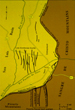
 Figure
2. Taos Plateau, NM – Geological training ground from Apollo to the
present, from space. Figure
2. Taos Plateau, NM – Geological training ground from Apollo to the
present, from space.
 Figure
3. Taos Plateau, NM, at the surface.
Dave Scott and Jim Irwin
train on the rim of the Rio Grande gorge, a 1:1 analogue to Hadley Rille,
Apollo 15 exploration site (Schaber, 2002).
Field training continues here for Space Shuttle, International Space
Station astronauts, some of whom may explore Mars or direct a Mars
mission from the ground. Figure
3. Taos Plateau, NM, at the surface.
Dave Scott and Jim Irwin
train on the rim of the Rio Grande gorge, a 1:1 analogue to Hadley Rille,
Apollo 15 exploration site (Schaber, 2002).
Field training continues here for Space Shuttle, International Space
Station astronauts, some of whom may explore Mars or direct a Mars
mission from the ground.
 Figure
4. Taos Plateau, NM, exercise in sampling techniques (left) and training
in stereophoto analysis (right). Figure
4. Taos Plateau, NM, exercise in sampling techniques (left) and training
in stereophoto analysis (right).
 Figure
5. Taos Plateau, NM, geophysical methods, specifically gravimetric
surveys. Training in gravity data acquisition to delineate buried
structures began in 1999. Gravimetric surveying is nondestructive and
requires no external energy input; the instrument is lightweight,
portable, and flight-certified. L - Gordon Cooper and Marty Kane read
gravimeter, Apollo field training (Schaber, 2002).
R - Chris Ferguson,
John Young, and Barbara Morgan collect gravity and GPS data. Figure
5. Taos Plateau, NM, geophysical methods, specifically gravimetric
surveys. Training in gravity data acquisition to delineate buried
structures began in 1999. Gravimetric surveying is nondestructive and
requires no external energy input; the instrument is lightweight,
portable, and flight-certified. L - Gordon Cooper and Marty Kane read
gravimeter, Apollo field training (Schaber, 2002).
R - Chris Ferguson,
John Young, and Barbara Morgan collect gravity and GPS data.
 Figure
6. Taos Valley ground-water assessment. Faults influence ground-water
distribution and flow paths in Taos Valley. Good bedrock/valley fill
density contrast is favorable for gravity method; structural setting was
ideal. Gravity data helped define faults buried beneath valley fill.
Data were used by NM Bureau of Geology in water-resource assessment of
fast-growing area. (Map from Bauer et al., 1999.) Figure
6. Taos Valley ground-water assessment. Faults influence ground-water
distribution and flow paths in Taos Valley. Good bedrock/valley fill
density contrast is favorable for gravity method; structural setting was
ideal. Gravity data helped define faults buried beneath valley fill.
Data were used by NM Bureau of Geology in water-resource assessment of
fast-growing area. (Map from Bauer et al., 1999.)
 Figure
7.
Taos Valley, Bouguer gravity profile defining
a buried fault that influences ground-water movement. The sharp
inflection at the right (east) end of the Bouguer gravity profile marks
a buried fault with no surface expression; displacement measures
thousands of feet. (NM Bureau of Geology and Mineral Resources, 2000). Figure
7.
Taos Valley, Bouguer gravity profile defining
a buried fault that influences ground-water movement. The sharp
inflection at the right (east) end of the Bouguer gravity profile marks
a buried fault with no surface expression; displacement measures
thousands of feet. (NM Bureau of Geology and Mineral Resources, 2000).
 Figure
8. Taos Valley, seismic exercises.
Field trials have been conducted for
shallow-target seismic reflection exercises. Figure
8. Taos Valley, seismic exercises.
Field trials have been conducted for
shallow-target seismic reflection exercises.
 Figure
9. Future training will include other sampling techniques – spring
waters, sedimentary deposits, and organic material. Figure
9. Future training will include other sampling techniques – spring
waters, sedimentary deposits, and organic material.
Return
to top.
Integrative Interrogation –
Preceding and Throughout Surface Exploration
This aspect of training involves the
following:
1. Observe, map, and interpret planetary
surfaces and processes - Earth, her Moon, Mars, Phobos, Deimos, Europa...
Satellite images - Clementine, Viking,
Galileo, Landsat, SPOT, Ikonos, Mars Global Surveyor (more detailed
coverage for much of Mars than for most of Earth at present)...
Astronaut-acquired photos (>450,000 images, including stereophoto
mapping suites; some taken specifically for comparison with lunar,
martian images); SRTM data.
2. Integrate relevant
observations/interpretations; compare analogous data for the several
planetary bodies.
Similar Features
Formed by Processes Like Those on Earth
(Figures 10-16)
 Figure
10. Emi Koussi volcanic crater, Tibesti Massif, Chad. Figure
10. Emi Koussi volcanic crater, Tibesti Massif, Chad.
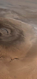 Figure
11. Olympus Mons, Mars. It constitutes most of the Tharsis Bulge, and it
is 27 km high – 3 times the height of the island of Hawaii (9 km from
subsea base to summit). Like Hawaii and Tibesti Massif, it may have
formed over a mantle hotspot. (MO2C-69). Figure
11. Olympus Mons, Mars. It constitutes most of the Tharsis Bulge, and it
is 27 km high – 3 times the height of the island of Hawaii (9 km from
subsea base to summit). Like Hawaii and Tibesti Massif, it may have
formed over a mantle hotspot. (MO2C-69).
 Figure
12. Shifting sands.
Longitudinal (parallel to dominant wind direction),
transverse (perpendicular), and star dunes (variable wind directions)
are known on Earth (left) and Mars (right) (Greeley, 1987). Figure
12. Shifting sands.
Longitudinal (parallel to dominant wind direction),
transverse (perpendicular), and star dunes (variable wind directions)
are known on Earth (left) and Mars (right) (Greeley, 1987).
 Figure
13. Layered rocks of varied origins, Grand Canyon. Sequences of layers
of varied origins are common on Earth. The Grand Canyon has been carved
through marine limestones, desert dune deposits, and ancient lava flows. Figure
13. Layered rocks of varied origins, Grand Canyon. Sequences of layers
of varied origins are common on Earth. The Grand Canyon has been carved
through marine limestones, desert dune deposits, and ancient lava flows.
 Figure
14. Layered rocks on Mars, Coprates Chasma. Viking images (1970s) first
revealed layered strata on Mars. Mars Orbital Camera (MOC) data provide
more detailed views. Figure
14. Layered rocks on Mars, Coprates Chasma. Viking images (1970s) first
revealed layered strata on Mars. Mars Orbital Camera (MOC) data provide
more detailed views.
 Figure
15. Complex impact craters.
Manicouagin,
Quebec (left); Copernicus, Earth’s Moon (right). Figure
15. Complex impact craters.
Manicouagin,
Quebec (left); Copernicus, Earth’s Moon (right).
 Figure
16. Glaciers on Earth and Mars.
Southern Andes, Chile (left); North
Pole, Mars (right) (Greeley, 1987). Figure
16. Glaciers on Earth and Mars.
Southern Andes, Chile (left); North
Pole, Mars (right) (Greeley, 1987).
Astronaut-acquired photographs and satellite
data permit detailed comparisons of the following:
-
Great volcanoes (Mars,
Jupiter’s moon Io) (Figures 10,
11)
-
Dunes (possibly finer
sediment on Mars) (Figure 12)
-
Layered strata of varied origins (extrusive igneous, volcaniclastic,
sedimentary) (Figures 13,
14)
Similar Features Formed by Potentially Different Processes (Figures
17-23)
 Figure
17. Catastrophic flood?, Candor Chasma, Mars (USGS, 1992, detail).
Observations: Abrupt breaks in walls of Valles Marineris. Apparent
scours extend out several kilometers. Tremendous erosive power required.
Possible mechanism - sudden release of large volume of glacial meltwater
in response to volcanic heating? Figure
17. Catastrophic flood?, Candor Chasma, Mars (USGS, 1992, detail).
Observations: Abrupt breaks in walls of Valles Marineris. Apparent
scours extend out several kilometers. Tremendous erosive power required.
Possible mechanism - sudden release of large volume of glacial meltwater
in response to volcanic heating?
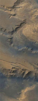 Figure
18. Details of possible flood erosion, Candor Chasma, Mars, showing deep
scouring of valley floors, undercut valley walls, slumps and landslides,
and blocky deposits on valley floor. Figure
18. Details of possible flood erosion, Candor Chasma, Mars, showing deep
scouring of valley floors, undercut valley walls, slumps and landslides,
and blocky deposits on valley floor.
 Figure
19. Cascade Range, Eastern Washington State, and channeled Scablands,
along the Columbia River east of the range. The Scablands are possible
analogue for large-scale breaches of canyon walls on Mars.
Bedrock
scours resulted from ice-dam burst and abrupt release of great volumes
of water. Figure
19. Cascade Range, Eastern Washington State, and channeled Scablands,
along the Columbia River east of the range. The Scablands are possible
analogue for large-scale breaches of canyon walls on Mars.
Bedrock
scours resulted from ice-dam burst and abrupt release of great volumes
of water.
 Figure
20. Moses Lake and coulees, Eastern Washington State. Glacial ice dams
broke between 18,000 and 13,000 years ago, in response to volcanism near
modern Lake Pend Oreille, ID. 500 mi3 of
melt water stripped away the glacial soil and carved deep valleys
(coulees) into the bedrock. The coulees were formed in five catastrophic
events; glacial Lake Missoula was the source of the flood waters. Figure
20. Moses Lake and coulees, Eastern Washington State. Glacial ice dams
broke between 18,000 and 13,000 years ago, in response to volcanism near
modern Lake Pend Oreille, ID. 500 mi3 of
melt water stripped away the glacial soil and carved deep valleys
(coulees) into the bedrock. The coulees were formed in five catastrophic
events; glacial Lake Missoula was the source of the flood waters.
 Figure
21. Large lake basin, old shorelines: Mega-Lake Chad.
Present Lake Chad
occupies only a small portion of a far larger basin.
Former shorelines,
cut by waves, and abandoned river deltas are visible in surrounding
topography. Large lake basins are possible analogues for North Highlands
features, Mars? Figure
21. Large lake basin, old shorelines: Mega-Lake Chad.
Present Lake Chad
occupies only a small portion of a far larger basin.
Former shorelines,
cut by waves, and abandoned river deltas are visible in surrounding
topography. Large lake basins are possible analogues for North Highlands
features, Mars?
 Figure
22. Lake Chad, details of oil shorelines and river delta. Figure
22. Lake Chad, details of oil shorelines and river delta.
 Figure
23. Lop Nur, China, with evaporites marking old shorelines. Figure
23. Lop Nur, China, with evaporites marking old shorelines.
Return
to top.
Photographs and satellite data show
“look-alike”features, as demonstrated by the following:
No surface water and little water ice on Mars
now
Flow conditions at 1/3 the Earth’s
gravitational acceleration?
At subzero temperatures?
Long-lived water supply?
-
Apparent springs and seeps
-
Apparent catastrophic
floods; Source of water? Other fluid? (Figures
17,
18, 19,
20)
-
Melted subsurface ice (H2O,
CO2)? Methane
clathrate?
-
Possible shorelines
(Figures 21, 22,
23)
Bodies of standing water — lakes and seas?
Lava-filled basins?
Satellite observations, imaging, mapping,
systematic scientific comparison with terrestrial and known lunar
sites.
Testing complex robotic (with/without humans)
systems on the Moon before going to Phobos, Deimos, Mars...
Applying the investigative/integrative power
of human explorers in concert with intelligent robots.
Your Mission
(the mission of humans exploring the planets):
Characterize the geology of Earth and discuss
the origin and evolution of the planet.
 Figure
24. Geologic map of the conterminous United States (USGS,2000), with
lunar land sites referenced to the map. Figure
24. Geologic map of the conterminous United States (USGS,2000), with
lunar land sites referenced to the map.
Astronaut-acquired photographs of Earth are
made available to the public by the Earth Science & Image Analysis
Laboratory (http://eol.jsc.nasa.gov),
NASA-Johnson Space Center. Mars Orbital Camera (MOC) images from Mars
Global Surveyor are made available by Malin Space Systems/NASA
http://www.msss.com). Apollo 17
photographs are made available by NASA-Johnson Space Center (http://images.jsc.nasa.gov/iams/html/pao/as17.htm).
Return
to top.
Bauer, P.W., Johnson, P.S., and Kelson, K.I.,
1999, Geology and hydrogeology of the southern Taos valley, Taos
County, New Mexico: Socorro, New Mexico Bureau of Geology and Mineral
Resources, Final Technical Report to New Mexico Office of the State
Engineer, 56 p., 4 pl.
Bauer, P.W., Read, A., and Johnson, P.S.,
2000, Astronaut geophysical training, Taos, New Mexico, Summer 1999: New
Mexico Bureau of Geology and Mineral Resources,
http://geoinfo.nmt.edu/penguins/summary.html
Dickerson, P.W., Muehlberger, W.R., and
Bauer, P.W., 2000, Astronaut training in field geophysical methods:
Albuquerque, AIAA Space 2000 conference proceedings, 7 p.
Greeley, R., 1987, Planetary Landscapes:
Boston, Allen & Unwin, 275 p.
Schaber, G. G., 2002, The U.S. Geological
Survey’s Role in Man’s Greatest Adventure (The Apollo Expedition to the
Moon): USGS Planetary Geology Branch, unpublished photo CD for
dedication of Shoemaker building (September, 2002), 93 figures.
U.S. Geological Survey, 2000, A tapestry of
time and terrain: U. S. Geological Survey,
http://tapestry.usgs.gov/Default.html
U.S. Geological Survey, 1992, Valles
Marineris: U.S. Geological Survey, Mars [color] Digital Image Mosaic
disks, volume 13. Electronic version available from Malin Space Science
Systems --
http://www.msss.com/mars/pictures/usgs_color_mosaics/usgs-color.html
Willis, K., Dickerson, P.W., and McRay, B.H.,
1998, Canyons, craters and drifting dunes — Terrestrial analogues on
Earth’s Moon and Mars: NASA-Johnson Space Center, Office of Earth
Sciences,
http://eol.jsc.nasa.gov/newsletter/planetary/sld001.htm
=================================
 Figure
25. Surface exploration of the moon. Figure
25. Surface exploration of the moon.
Man must rise above the Earth – to the top of
the atmosphere and beyond – only thus will he fully understand the
world in which he lives.
Socrates, 500 B.C.
Return
to top.
|
 Figure
1. Surface exploration readiness.
Figure
1. Surface exploration readiness.