![]() Click to view images of figures in PDF format.
Click to view images of figures in PDF format.
Geology of Meso-Cenozoic Basins in Central Armenia, with Comment on Indications of Hydrocarbons
By
R. Jrbashyan*, G. Chlingaryan*, Yu. Kagramanov, A. Karapetyan*, M. Satian,
Yu. Sayadyan, H. Mkrtchyan
Search and Discovery Article #30007 (2001)
Adaptation of part of a report of the National Academy of Sciences of the Republic of Armenia, entitled Geology and Oil and Gas Prospects of Meso-Cenozoic Sedimentary Basins of the Central Part of Armenia.
*Editors of report; English translation received from Tim Papworth, Armenian American Exploration Company Inc. ([email protected]). Please contact Mr. Papworth for additional information.
In the Lesser Caucasus, successor central Armenian basins are sandwiched between the more prominent Kura-Rioni Basin on the north and east and the Arax River Basin to the west and south. They are smaller; the sedimentary section is thinner; and they contain considerable volumes of terrestrial and subaqueous volcanic rocks in addition to molasse and flysch-like sediments. The sedimentary history of the Lesser Caucasus, which began after the Caledonian and/or Hercynian orogenies, includes development, infilling, and deformation of Variscian and early Cimmerian basins and then of Alpine basins before Pliocene-Quaternary tectonism and volcanism; both are related to the collision and northerly movement of the Arabian plate with respect to the Eurasian plate.
In central Armenia, two Paleocene-Miocene flysch-molasse troughs, Central and Sevan, have been identified. They are totally different tectonically—the former occupies part of an anticlinorium, whereas Sevan Trough belongs to a zone of ophiolitic sutures.
Several oil and gas shows have been reported from these troughs in Paleogene and Neogene strata.
|
uComments on tectonics of Lesser Caucasus tVariscian and Early Cimmerian sedimentary basins wEarly-Middle Alpine sedimentary basins wLate Alpine sedimentary basins tPliocene-Quaternary uplifts and troughs
uComments on tectonics of Lesser Caucasus tVariscian and Early Cimmerian sedimentary basins wEarly-Middle Alpine sedimentary basins wLate Alpine sedimentary basins tPliocene-Quaternary uplifts and troughs
uComments on tectonics of Lesser Caucasus tVariscian and Early Cimmerian sedimentary basins wEarly-Middle Alpine sedimentary basins wLate Alpine sedimentary basins tPliocene-Quaternary uplifts and troughs
uComments on tectonics of Lesser Caucasus tVariscian and Early Cimmerian sedimentary basins wEarly-Middle Alpine sedimentary basins wLate Alpine sedimentary basins tPliocene-Quaternary uplifts and troughs
uComments on tectonics of Lesser Caucasus tVariscian and Early Cimmerian sedimentary basins wEarly-Middle Alpine sedimentary basins wLate Alpine sedimentary basins tPliocene-Quaternary uplifts and troughs
uComments on tectonics of Lesser Caucasus tVariscian and Early Cimmerian sedimentary basins wEarly-Middle Alpine sedimentary basins wLate Alpine sedimentary basins tPliocene-Quaternary uplifts and troughs
uComments on tectonics of Lesser Caucasus tVariscian and Early Cimmerian sedimentary basins wEarly-Middle Alpine sedimentary basins wLate Alpine sedimentary basins tPliocene-Quaternary uplifts and troughs
uComments on tectonics of Lesser Caucasus tVariscian and Early Cimmerian sedimentary basins wEarly-Middle Alpine sedimentary basins wLate Alpine sedimentary basins tPliocene-Quaternary uplifts and troughs
uComments on tectonics of Lesser Caucasus tVariscian and Early Cimmerian sedimentary basins wEarly-Middle Alpine sedimentary basins wLate Alpine sedimentary basins tPliocene-Quaternary uplifts and troughs
uComments on tectonics of Lesser Caucasus tVariscian and Early Cimmerian sedimentary basins wEarly-Middle Alpine sedimentary basins wLate Alpine sedimentary basins |
Click here for sequence of Figures 3-7.
Click here for sequence of Figures 3-7.
Click here for sequence of Figures 3-7.
Click here for sequence of Figures 3-7.
Click here for sequence of Figures 3-7.
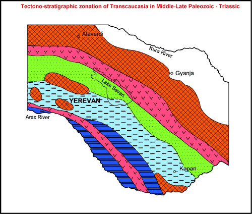
The central part of the complex mountain structure of the Lesser Caucasus, being elevated above the Kura and Arax valley basins (Fig. 1), contains deposits of two basins in Central Armenia, where, between the Aragats Mountain Area in the west and the Lake Sevan area in the east, is a substantial cover of Recent volcanic flows. Yet available information is sufficient to identify the Paleocene-Miocene flysch-molasse Central and Sevan troughs. They are totally different tectonically. The Central Trough belongs to the Hankavan-Meghri tectonic zone (anticlinorium). To the north and south, the trough is bounded by Baikalian basement uplifts; the depth to basement in its central part is estimated at about 5 km. Its sediment cover is dominated by Paleogene flysch and Miocene molasse. The latter includes thick Middle Miocene evaporites, including salt, which served as source for a number of salt domes in the south. Upper Cretaceous carbonates and clastics are not as thick. Lower Cretaceous and even Jurassic sediments may also be present. It is possible that a thin Upper Paleozoic - Triassic carbonate section may be present. The west boundary of the trough is formed by the Aragats strato-volcano basement high; the east boundary, by the Geghama volcanic highland basement high. The Sevan Cenozoic flysch-molasse trough is located east of the highlands; it belongs to the orogenic zone of the ophiolite sutures (Sevan and Shirak-Zangezur). Included also are the eastern edge of the Hankavan-Meghri tectonic zone, the Shirak-Zangezur ophiolite suture, and central sector of the Bazum-Kapan tectonic zone. Pliocene-Quaternary molasse fills the Holocene pan of the lake and the adjacent piedmont plains. On the west, the Sevan Trough is bounded by basement highs, associated with the Geghama Uplift. The structure of the pre-Paleogene formations is not known; it is likely that the molasse trough is discordant over the older regional structure. The sediment cover in its southern part is at least 5 to 7 km thick, probably inclusive of Upper Paleozoic - Triassic section. Comments on Tectonics of Lesser Caucasus Pre-Alpine basement in the area of Lesser Caucasus (Transcaucasus) consists of phyllite, schist, and metavolcanite, in fault contact with granites, serpentinites, and other rock types related to Hercynian and/or Caledonian tectonism (Adamia et al., 1989; Khutsishvili, 1978). Imbricate structure of basement rocks may have resulted from right slip (Kazmin and Sborshchikov, 1989) rather than nappe development. The sedimentary section is represented mainly by Mesozoic and Cenozoic shallow-water sediments, although there are some areas with Middle-Upper Paleozoic deposits. The total thickness of Paleogene-Neogene sediments reaches 5-7 km and more in part of the Kura-Rioni foredeep basin. The Lesser Caucasus is connected to part of the Kura-Rioni Basin by a flexure of the Somkhet-Karabakh Zone and a conjugate fault system. The Somkhet-Karabakh Zone (Fig. 1), from the main phase of Cimmerian folding, trends northwest (extending to the Pontian structures in Turkey) to southeast (extending to the east-trending Elburz structures in Iran). The basement is overlain by Liassic terrigenous deposits. Over most part of Somkhet-Karabakh Zone, they are overlain by a thick andesite-basalt-dacite section (Aalenian-Bajocian in age). South of the Somkhet-Karabakh Zone is an area of Alpine folding (Gabrielian et al., 1968). Most of the terrain covered by the Recent volcanics is confined to the area of Alpine-type folding. Ophiolitic sections of oceanic or transition-type crust fragments dated as Late Triassic, Late Jurassic-Early Cretaceous, and Albian-Turonian, contain indications of both Austrian deformation and early and late Cimmerian folding. A crucial role in the formation of the modern structure of the area, and probably beyond, was played by the three ophiolitic sutures: Sevan-Akeri, Zangezur, and Vedi (Fig.1). The Urts-Julfa Zone, located south of the Vedi Ophiolitic Zone, is characterized by the development of a thick Middle-Upper Paleozoic complex below Upper Cretaceous and moderately thick Paleogene sections. To the south, the Urts-Julfa Zone borders on the Palmira-Apsheron Lineament that formed in the Paleozoic .Volcanics are present in the Julfa region. The Urts-Julfa Zone is limited by the uplifted basement of the Mt. Great Ararat to the south and by the Hrazdan Transverse Fault Zone to the west. Intersection with the Vedi Ophiolitic Belt is marked by a transition from alkali-basaltic volcanism to tholeiitic volcanism in the Mesozoic section. Collision of the Arabian and Eurasian plates caused formation of the tectonic features in the general Causasus (both Greater and Lesser) (Fig. 2). According to De Mets et al. (1990), the Arabian Plate is moving NNW (338°) at a rate of 28 mm/year. However, the authors are of the opinion that movement is in a NNE direction (R. Jrbashyan, personal communication, 2001). According to Sengor and Kidd (1979), the collision began 13 million years again, while Philip et al. (1989) think that it began 5 million years ago. Activity along linear volcano chains in the zone of convergence in the Armenian upland was especially intensive in Late Miocene, Pliocene, and Quaternary time (Karapetian, 1969; Shirinian, 1970). Some of the Late Pliocene-Quaternary volcanic structures are controlled by faults related to microplate movement and northerly subduction (Kazmin et al., 1987; Sadoyan, 1989). . Relatively isolated strato-volcanic structures, such as Ararat and Aragats, occur at or near fault intersections. The Kura-Rioni intermontane basin, bordering overthrusts of Greater Caucasus to the north, represents a zone of extension where more than 8 km-thick sediments accumulated in Neogene-Quaternary. Variscian and Early Cimmerian Sedimentary Basins (Fig. 3) The Gondwana facies, Middle-Late Paleozoic in age, are grouped with Lower-Middle Triassic carbonates. These shallow-marine deposits contain carbonates, quartzose sandstones, and other terrigenous units, local bituminous limestone, and clay, totaling 1500 m. Thickness decreases to the northeast from the Vedi River Basin and to the west from the Hrazdan River Valley. The Permian section contains bituminous limestones, calcareous sandstones, and shales in the southern part of Central Armenia (in the Ararat region near Nakhichevan), and in southeasternmost part of Armenia. The Hercynian Orogeny considerably changed the distribution and character of the sedimentary rocks and of the basins— perhaps in some cases in association of the closure and opening of stages of the Tethys. Geologic evolution of the region from Early Jurassic to Quaternary time is signified by an intensification of tectonic movements and a sharp increase in volcanic activity. Mesozoic basins--mainly terrigenous troughs--followed the closure of Paleozoic sedimentary basins. In these troughs, volcanic facies is very common, along with shallow-water sedimentary facies. Early-Middle Alpine Sedimentary Basins (Figs. 4, 5, 6) Evolution of Tethyan active margins in Early Jurassic time was chiefly characterized by the formation and expansion of different tectonic structures that developed in place of closed Paleozoic basins. The Mesozoic ophiolitic basins represent a special category of troughs, which are quite extensive, including deep-water siliceous-carbonate-volcanic strata having been intruded by serpentinitic bodies--remnants of mantle diapir folds; the ophiolite-association rocks are not in-place. The Somkhet-Karabakh Zone was an island arc within a recurring and chain-like Tethys (Shteklin, 1984), and the sedimentary (carbonate-terrigenous) Hankavan-Meghri and Urts-Julfa basins represent shallow-marine settings, accompanying island-arc basement. Until the end of Early Jurassic, rhyolitic-andesitic volcanism, with small contribution of basaltic-type, was fairly widespread. Compression began at the end of the Liassic, with its maximum in the Bajocian, possibly in an environment similar to the formation of island arcs (Ostroumova et al., 1987). In the south, near Arax, Liassic volcanics are overlain by Bajocian-Bathonian sandstones and carbonates. In Middle Jurassic time, starting from Bajocian, compression resulted essentially in reconstruction of sedimentary basins. The composition of Bajocian volcanic rocks varies greatly. Pre-Callovian folding had an essential impact on the tectonic development of island-arc zones – Somkhet-Karabakh and Kapan segments. Callovian terrigenous, coal-bearing deposits and Oxfordian-Kimmeridgian volcanic-terrigenous-carbonate deposits unconformably overlie Middle Jurassic deposits. In the general area, the Late Jurassic transgression, resulting from a major eustatic rise in sea level, was influenced strongly by considerable narrowing of the Tethys and small-scale rifting. Flagstone-like limestones (Oxfordian-Tithonian) were deposited transitional to the micro-oceanic Sevan-Akeri Trough facies (Bergougnan, 1976). Basins during Late Cretaceous were characterized by volcanism. In the Fore-Lesser Caucasus Trough, the upper part of the Upper Cretaceous section contains limestone, 100-800 m thick. Terrigenous and, to a lesser degree, carbonate deposition occurred in the Hankavan-Meghri and Urts-Julfa zones during Albian-Coniacian in shallow-water basins within the general area of uplifts (Fig. 5). Closure of ophiolitic rifts resulted in the formation of horsts and grabens, with ophiolitic clastic deposits in the latter. Late Senonian, reflecting the rise of sea level, was characterized by deposition of carbonate rocks – predominantly micritic limestones, almost throughout the area. The thickest sections, reaching 600 m, are within the northern edge of the Sevan Ophiolitic Zone, at the contact with the Somkhet-Karabakh Zone. Presently, in a narrow belt of uplift, along the axis of the Sevan Basin, Senonian is absent or is thin. Early Campanian andesite-dacitic and rhyolitic volcanism occurred mainly in the northern part of the relatively deep-water Late Senonian basin of the Somkhet-Karabakh Zone and partly on its southern boundary. Late Campanian basaltic volcanism occurred along the periphery of the SE Zangezur and Sevan-Akeri ophiolitic zones. Laramide folding of varying intensity occurred over the whole area. The Paleogene section thins towards the south from Georgia, in the direction to the Somkhet-Karabakh Zone. The southern part of the Alaverdi Anticlinorium (basin of the Martsiget River) contains a lower Eocene carbonate-terrigenous, coal-bearing formation. The principal Paleocene-Eocene sedimentary basins in Lesser Caucasus are: Shirak-Sevan Basin in the north, Yerevan-Ordubad Basin in the south, and the western sector of the Hankavan-Meghri Zone (in the Central Trough), located between them (Fig. 6). The first two of these sedimentary basins have inherited the main features of ophiolitic sutures, but the Central Trough is superimposed on a zone of metamorphosed basement uplifts and in the area of a sharply reduced Mesozoic section. Apparently, basins widened in the Paleogene, encompassing the edges of the Sevan-Akeri and Zangezur sutures as well as the northern slopes of the Hankavan-Meghri Upland. In the Shirak sector are widely developed acidic volcanics (Jrbashyan, 1964, 1981), which alternate with sandstone layers containing nummulitoids. Poorly sorted terrigenous sediments and welded tuffs are present higher in the section. Total thickness of these shallow-marine deposits reaches 1.5-2.5 km. The Upper Eocene shallow-water, volcanic-sedimentary formations with conglomerates at the base are less than 200-250 m. During Eocene, volcanism, structurally related to the ophiolitic sutures, was mainly explosive and distributed linearly along the largest Sevan-Akeri Ophiolitic Belt. The northern side of the ophiolitic Vedi Suture is characterized by an asymmetrical distribution of volcanism. South of the suture, Early-Middle Paleogene sections have reduced thicknesses and are represented mainly by sediments. The lithofacies and thicknesses of Early-Middle Paleogene rocks have a more complex distribution between the ophiolitic sutures. In Paleogene, there was chiefly compression in the north end of the Armenia block and extension in the southeastern part, apparently determining the type and character of volcanism as well as the lithofacies of Paleogene flysch-like/volcanic sedimentary basins (Jrbashyan, 1990; Sadoyan, 1989). The early-middle Paleogene flysch-like basins are classified into: a) basins superimposed on the basement elevations (Central Trough); these are discontinuous, separated by basement uplifts and zones of intense volcanic activity; b) basins over ophiolitic sutures. The second group of basins extended over hundreds of kilometers and were developed along Mesozoic ophiolitic zones or zones, with sedimentation usually accompanied by intense explosive volcanism. Late Alpine Sedimentary Basins (Fig. 7) In the Lesser Caucasus, marine molasse occur only in the Vedi (Yerevan-Ordubad) Zone and south of the Central Trough, although their development in the southwest part of Sevan Basin is also possible. Lagoon-marine Oligocene occurs in the central part of the Sevan-Akeri Zone. Bituminous shales and rarely coal were deposited in this fresh-water basin. The early-middle Oligocene basin in the south was site of shallow-marine deposition (Gabrielian, 1964). The basin deepened, with deposition of sand and clay, before shoaling in middle Oligocene, when coral reefs developed and nummulites, thick-walled, intricately sculptured large gastropods, and pelecypods flourished. Deposition of molasse continued to the end of middle Oligocene in the intermontane basins. Marine sedimentation was resumed locally in late Oligocene and early Miocene. Vari-colored continental molasse, with a thickness of 800 m, was developed in the Central trough. In the Yerevan-Sevan Transverse Trough, the equivalent sediments are gypsum-bearing clays with beds of bryozoan and gastropod limestones. Uplifts to the west of Shirak-Sevan Basin became connected to the Somkhet-Karabakh uplift. An evaporative sedimentary basin formed to the south, with salt-gypsum-bearing strata containing clay, siltstone, and sandstone layers, locally reaching 1 km. The salt-bearing benches change to gypsum-bearing and terrigenous deposits toward the uplands. Another evaporative sedimentary basin formed in the southeast part of the Central Trough, where its sediments are 1 km thick. The Zangezur Ophiolitic Suture at the axis of the basin was apparently the northern boundary of the deposition of salt-gypsum. However, evaporites were deposited southeast of the Sevan-Akeri Zone. The Late Sarmatian (upper-late Miocene) sea entered the Central Trough from the south and north. It also reached the Lake Sevan Basin, where there are gas shows in the molasse. Vigorous orogenic movement, accompanied by volcanism occurred at the end of the Sarmatian. The molasse of the Vedi Zone and Central Trough have more complete stratigraphic columns, whereas in the Sevan-Akeri Zone, lower-middle Oligocene deposits are absent. Salt tectonics played an important role in the formation of Vedi and Central Trough structures. Pliocene-Quaternary Uplifts and Depressions (Fig. 8) The beginning of the neotectonic stage corresponds to the boundary between late Sarmatian and Meotian (late Miocene) (about 10 million years ago). Four main geologic-tectonic phases can be recognized: The boundaries of these phases represent very important stratigraphic milestones. Mio-Pliocene phase (Meotian and Pontian stages)—increase rate of activity Late Pliocene (Akchagylian) phase—complete sea withdrawal, with continental deposits in intermontane depressions (e.g., Shirak, Sevan); increase in volcanic activity. Eo-Pleistocene phase (Apsheron stage)—increase of tectonic movement and erosion; less intense volcanic activity than during previous phases. Pleistocene-Holocene phase—growth and expansion of Lesser Caucasus; relative subsidence in the Shirak, Sevan and other basins, with deposition of lacustrine and alluvial units; vigorous volcanic activity. Total uplift of the Lesser Caucasus is estimated to have been 1.8 km on average. The following zones are recognized within the Lesser Caucasus in Armenia (Fig. 8): Northeast limb of the Lesser Caucasus--characterized by a relatively simple structure and absence of folding and volcanism in the neotectonic stages. Sevan-Shirak Zone--uplifts and troughs, with en echelon mountain ranges, troughs, succeeding Cretaceous and Eocene troughs. Central Armenian Zone—continental volcanics, inclusive of Aragats, Geghama, Vardenis, and Syunik uplifts, with flows and pyroclastic units, 200-1,000 m thick; representing a “volcano-tectonic depression” Milanovski (1962). Arpa-Vorotan Zone of troughs and uplifts--corresponding to a major Paleogene synclinorium, inclusive of several gentle anticlines and synclines. Urts-Zangezur Zone of differential uplifts--uplifts separated by small troughs, with maximum relative displacement of 3-3.5 km. Arax Intermontane trough—inclusive of Ararat Basin, with origin as a compensating structure in the late stages of consolidation of the Lesser Caucasus in Oligocene-Miocene time (Kozhevnokov, Kozhevnokova, Sayadyan, 1973). Sevan and Central Troughs (Fig. 9) Sevan Trough Sevan Basin, or Trough, represents a tectonic basin complicated by grabens and faults. It was formed during late Miocene - Quaternary (Milanovski, 1922). At the end of the Sarmatian, the waters of the huge inland Pont-Caspian Lake penetrated into the basin, to form a bay, for the last time through the straits of the Nakhichevan and Yerevan troughs. In Meotian time the bay turned into a lake, which has almost continuously existed to Holocene time. Starting from Meotian until modern time, the Sevan Basin is subsiding relative to the intermittent uplift of the Lesser Caucasus; the rate of its uplift is considerably lower than that of the whole region. The basin was filled with a series of lacustrine deposits, separated by unconformities and with alluvial and volcanic deposits on the periphery. Troughs are present within the basin, along with narrow, transverse uplift(s) and a longitudinal horst. Uplift of the former has periodically dammed Lake Sevan. A major fault separates the Sevan Basin from the Areguni Range, bordering the basin on the northeast. A younger fault with vertical displacement of 100m extends along the western end of the basin. Quaternary flows played a crucial role in supporting the impoundment of the lake and outflow of Hrazdan River. The lake acquired its present size only at the end of Late Pleistocene-Holocene, after renewal of local tectonic uplift, and flows from Upper Hrazdan area and the melting of Late Pleistocene glaciers bordering the Sevan Basin (Aslanian, 1979). There are only a few oil and gas indications in the Sevan Trough. Gas shows and cuts of oil encountered during drilling on the southwestern shore of Lake Sevan (Yeranos-1) suggest that the molasse is prospective for hydrocarbons. The Central Trough occupies the western part of an anticlinorium (Hankavan-Meghri tectonic zone), superimposed on a zone of metamorphosed basement. The sedimentary section is thought to be approximately 5 km thick in the central part. It is bounded on the north and south by Baikalian basement uplifts. The west boundary of the trough is the Aragats Uplift; the east boundary is the Geghama volcanic basement uplift. The sediments are predominantly Paleogene flysch and Miocene molasse; included in the latter are thick evaporites, gypsum and salt, resulting in the presence of salt domes in the south. The molasse of the Central Trough, unlike that of the Sevan Trough, is characterized by a fairly complete stratigraphic section of the lower-middle Oligocene. Thinner Upper Cretaceous carbonates and clastics are present, as well as Lower Cretaceous and possibly Jurassic strata. Further, thin Upper Paleozoic - Triassic carbonate section may be present. The structure of this basin, as well as the Sevan Trough, is masked under a substantial bulk of Upper Neogene-Quaternary volcanics. The Shoraghbyur High (Fig. 8) in the southeastern part of the trough was the structural feature where shows were recorded from several intervals in the Shoraghbyur-1. Included were an oil flow from a Paleocene horizon (3,474 to 3,589 m) and oil-cut mud from 3,640 to 3,634 m. The Paleocene and Lower Eocene of the subthrust section yielded oil-saturated cuttings. Oil-cut mud and oil-stained cuttings were reported as features of the upper Eocene section in Garni-1. Gas shows are reported in a number of wells over the Hrazdan structure. The Avan salt-dome area, between Hrazdan and the Vokchaberd Plateau, had oil shows in the Middle Miocene section. Adamia, Sh.A., Gabunia, G.L., Kutelia, Z.A., Khutsishvili, O.D., and Tsimakuradze, G.K., 1989, Tectonic features of Caucasus. In: Geodynamics of Caucasus (Ed. by Belov, A.A., and Satian, M.A.), Moscow, Nauka Publishers, 1989, p. 3-15 (in Russian). Aslanian, A.T., 1979, The problem of origination of Lake Sevan in the light of modern data. Izvestiya akademii nauk Arm. SSR, Nauki o zemle [Bulletin of Ac. Sci. of Arm. SSR, Earth Sciences], v. 32, # 3, p. 3-10 (in Russian). Bergougnan, H., 1976, Structure de la Chaine pontique dans le Haunt-Kalkit (Nord-Est L’Anatolie). Bull. Soc. Geol. France, 1976, v. 18, no. 3. DeMets, C., Gordon, R.G., Argus, D.F., and Stein, S., 1990, Current Plate Motions. Geophys. J. Int., v. 101, p. 425-478. Gabrielian, A.A., and Dumitrashko, N.V., 1962, History of the development of relief. In: Geomorphology, v. 1, Geology of Armenian SSR, Ac. Sci. of Armenian SSR Publ., Yerevan, p. 483-514. Gabrielian, A.A., Adamian, A.I., Akopian, V.T., et al., 1968, Tectonic map and intrusive formations map of Armenian SSR. A letter of explanation. Yerevan, Mitk Publ. Jrbashyan, R.T., 1964, Relation of volcanism to transverse uplifts (on the example of Lesser Caucasus). Ac. Sci of Armenia Rep., Yerevan, v. 3, p.175-180 (in Russian). Jrbashyan, R.T., 1981, Paleogene volcanic formations. In: Magmatic and Metamorphic Formations of Armenian SSR, Ac. Sci. of Armenia Publ., p.331 (in Russian). Jrbashyan, R.T., 1990, Paleogene volcanic belts of Tethys Ocean closure zone (Lesser Caucasus). Tbilisi, 72 p. (in Russian). Karapetian, K.I., 1969, Upper-Pliocene-Quaternary magmatic formations and volcanism of Armenia. Izvestiya AN Arm. SSR, Nauki o zemle [Ac. Sci. of Armenia Publ., Earth Sciences], v. 3, p. 12-21 (in Russian). Kazmin, V.G., Sborshchikov, I.N., Riku, L.E., Zonenshain, L.P., Bulenzh and Knipper, A.L., 1987, Volcanic Belts as Markers of the Mesozoic-Cenozoic Active Margin of Eurasia. In: History of Tethys Ocean (Ed. by Monin, A.S. and Zonenshain, L.P.), USSR Ac. Sci. Publ., Inst. of Oceanology, Moscow, p. 58-73 (in Russian). Kazmin, V.G., and Sborshchikov, I.M., 1989, Paleozoic and Early Cimmerian deformations in the Caucasus and their place in the development of the Tethys Ocean. In: Geodynamics of Caucasus (Ed. by Belov, A.A., and Satian, M.A.). Moscow, Nauka Publ.,, p. 46-54 (in Russian). Khutsishvili, O.D., 1978, Tectonics and evolution of the Lok crystalline high. Tbilisi, Metsniereba Publ., 64 p. (in Russian). Milanovski, E.E., 1962, Sevan Basin. In: Geology of Armenian SSR, v. 1, Geomorphology, Ar. Ac. Sci. Publ., Yerevan, 1962, p. 115-136 (in Russian). Ostroumova, A.S., and Tsenter, I.Ya., 1987, Volcanic series in the Saatly superdeep well section. Sov. Geol., p. 79-89 (in Russian). Philip H., et al., 1989, The Caucasus: an actual example of the initial stages of continental collision. Tectonophysics, v. 161, p. 1-21. Sadoyan, A.A., 1989, Paleogene lithology of Armenian SSR. Yerevan, Arm. Ac. Sci. Publ., p. 287 p. (in Russian). Sengor, A.M., and Canitez, N., 1982, The North Anatolian Fault. AGU, GSA, Geodynamic Series, v. 7, 1982, p. 205-216. Shirinian, K.G., 1970, The main features of Plio-Pleistocene volcanism of Armenia. In: Geology of Armenian SSR, v. IV, Yerevan: Arm. Ac. Sci. Publ., p. 477-495 (in Russian). Shteklin, I., 1984, Orogenesis and evolution of Tethys in the Middle East. Appraisal of contemporary knowledge. Proc. 27th Int. Geol. Conf., Tectonics of Asia, V. 5. Moscow, Nauka Publ., p. 53-68 (in Russian). |
 Figure 1. Tectonic elements of Lesser Caucasus (by M.A. Satian).
 Figure 2. Active tectonic features of the collision zone of the Central
Eurasian and Arabian plates (by A.S. Karakhanian).
Figure 2. Active tectonic features of the collision zone of the Central
Eurasian and Arabian plates (by A.S. Karakhanian).  Figure 3.
 Figure 4. Tectono-stratigraphic zonation of Transcaucasia in Late
Triassic - Early Jurassic (by M.A. Satian).
Figure 4. Tectono-stratigraphic zonation of Transcaucasia in Late
Triassic - Early Jurassic (by M.A. Satian).  Figure 5. Tectono-stratigraphic zonation of Transcaucasia in Late
Jurassic – Late Cretaceous (pre-upper Senonian) (by M.A. Satian).
Figure 5. Tectono-stratigraphic zonation of Transcaucasia in Late
Jurassic – Late Cretaceous (pre-upper Senonian) (by M.A. Satian). Figure 6. Tectono-stratigraphic zonation of Transcaucasia in Paleogene
(by M.A. Satian and R.T. Jrbashyan).
Figure 6. Tectono-stratigraphic zonation of Transcaucasia in Paleogene
(by M.A. Satian and R.T. Jrbashyan).  Figure 7. Tectono-stratigraphic
zonation of Transcaucasia in Miocene-early-Pliocene (by M.A. Satian and
R.T. Jrbashyan).
Figure 7. Tectono-stratigraphic
zonation of Transcaucasia in Miocene-early-Pliocene (by M.A. Satian and
R.T. Jrbashyan). Figure
8. Tectonic features of Armenia (by Yu. Sayadian, including data from
E.E. Malinovski 1962, 1960, 1968; Gabrielian and Dumitrashko, 1962; S.P.
Balian, L.N. Zohrabian, A.T. Aslanian; A.A. Gabrielian, O.A. Sarkissian,
and G.P. Simonian).
Figure
8. Tectonic features of Armenia (by Yu. Sayadian, including data from
E.E. Malinovski 1962, 1960, 1968; Gabrielian and Dumitrashko, 1962; S.P.
Balian, L.N. Zohrabian, A.T. Aslanian; A.A. Gabrielian, O.A. Sarkissian,
and G.P. Simonian). 