![]() Click to
view page images in PDF format
Click to
view page images in PDF format
SEDIMENTARY PROCESSES AND SEQUENCE STRATIGRAPHY OF LAKE MICHIGAN
Gordon S. Fraser1, Todd A. Thompson2, Ted C.
Moore3, Joseph F. Atkinson4
1 Great Lakes Center, Buffalo State College
2 Indiana Geological Survey, Indiana University
3 Department of Geological Sciences, University of Michigan
4 Great Lakes Program, University at Buffalo
Setting
Lake Michigan, in the western part of the Great Lakes Basin, is the sixth largest freshwater lake in the world. It is 494 km long and 190 km wide at its widest. Mean lake level is about 177 m above mean sea level (MSL). It has a surface area of 57,800 km2 and a drainage basin of only 118,000 km2 so that most of its watersheds are small and contribute relatively little sediment. It is divided by a mid-lake ridge into a northern basin and a southern basin. The northern basin of the lake has a narrow shelf descending to a depth of 50m, a somewhat wider slope to 120m and a basin plain with a maximum depth of 282 m. The shelf-slope system is less well defined in the southern basin with a nearly uniform slope down to a basin plain with a maximum depth of 160 m.
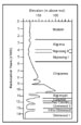
Lake Level History
The late Wisconsin and Holocene evolution of the southern Lake Michigan basin contrasts markedly with the evolution of ocean coasts because the Lake Michigan coast has experienced multiple transgressive and regressive events. Lake levels have been as much as 18 m higher and 60 m, or more, lower than present, and changes have often occurred at rates several times greater than the most rapid eustatic sea-level changes. Fluctuations occurred as a result of: (1) recession and advance of the ice margin, which supplied meltwater directly to the basin, opened and closed different outlets at different elevations, and volumetrically occupied part of the basin, (2) isostatic changes in the elevation of outlets which opened and closed different outlets or caused the elevation of the outlet to change through time; (3) fluvial downcutting of outlets; and (4) changes in the volume of water entering the lake basin in response to climatic change.
The Glenwood Phase highstand(s) began about 14.5 ka when recession of the Lake Michigan ice lobe formed a narrow lake between the ice margin and the morainal dam. Lake level apparently fell steadily throughout the Glenwood Phase and then more abruptly to the Two Creeks Phase lowstand shortly before 12 ka when receding ice opened a northern outlet. Readvance of the ice margin to the mid lake high at about 11.8 ka closed the northern outlets and raised lake level to the Calumet Phase at 189 m. This phase lasted about 600 to 800 years and ended about 11.2 ka when deglaciation joined Lakes Michigan and Huron and established the Algonquin Phase. Along the southern shore of Lake Michigan, lake level rapidly fell to about 180 m. Lake level subsequently rose slightly during the early part of this phase in response to isostatic rebound of the Kirkfield outlet, and lake level reached a maximum of 184 m about 10.6 ka.
Shortly before 10 ka, lake level began to fall to the extremely low levels of the Chippewa Phase. This phase began when the receding ice margin opened successively lower, isostatically-depressed outlets. Studies have suggested low elevations between 74 m and 116 m for the southern Lake Michigan basin.
The Chippewa Phase lasted between 4,500 and 5,000 years. From this extreme low, lake-level rose primarily in response to isostatic uplift of the North Bay outlet culminating in the Nipissing Phase(s) about 6.0 ka. Superimposed on this overall rise in lake level, an influx of water from the Lake Superior basin temporarily raised lake levels an unknown amount about 9.1 ka. At about 7 ka, lake level may have fallen below the level of the outlet because of sharply drier climate. Sometime between 6 and 5 ka, the character of the lake changed dramatically, probably due mostly to climatic causes, becoming highly undersaturated with respect to calcium carbonate and returning primary control of lake level to the isostatically rising North Bay outlet.
The Nipissing high phase(s) occupied reentrants along the coast producing scarps and terraces 4m or more above modern lake level. A short-term lowering of lake level at about 5.3 ka was followed by a second high stand at 4.5 ka. Over the next 4,500 years, lake-level fell 4m to the historical average for Lake Michigan, possibly because of erosion of the Port Huron outlet or climate change. Pervasive in paleo-hydrographs of the past 3.8 ka are quasi-period fluctuations of approximately 160 + 40 years and 32 + 6 years that continue into the historical record.
Hydrodynamic Processes
Lake Michigan experiences many of the same hydraulic processes that act in ocean basins, albeit at a smaller scale. The wave climate along the coast varies with respect to orientation to prevailing storm winds and to the length of fetch. For any given year, average maximum wave height along the Illinois shore is 2 m and individual waves rarely exceed 3 to 3.6 m.
Only very small lunar tidal effects have been documented for Lake Michigan, but other (quasi) periodic water level fluctuations occur that do have an effect on sediment transport and coastal processes. Seiches are tide-like rises and drops in Great Lakes coastal water levels caused by wind shear that push water toward one side of the lake, causing the water level to rise on the downwind side of the lake and to drop on the upwind side. When the wind stops, the water oscillates along the axis of the lake, with the nearshore water level rising and falling in decreasingly small amounts on both sides until it reaches equilibrium. Edge waves traveling around the lake can also cause periodic rises and falls along the coast. Coast-wise rectification of currents, coastal downwelling jets, and coriolis veering of lake currents have also been observed.
There are some phenomena, however, that appear to be unique to large lakes. The thermal bar occurs during spring and fall and can control inshore-offshore transport of particles and dissolved substances. It forms as surface water passes through 4°C, the temperature of maximum density in freshwater systems, and is characterized by a converging surface flow, offshore near the coast and on-shore in deeper water, with a downward turning and recirculation inshore and offshore, respectively. The offshore surface flow also tends to turn to the right (northern hemisphere) due to the Coriolis effect, consistent with a general counter-clockwise coastal circulation.
An annual major episodic plume of suspended material occurs along the southern shores of the lake. This plume is up to 10 km wide and extends over 200 km, and is a significant factor in sediment cycling. It starts on the southwestern shore and Coriolis forces cause the plume to follow the coastline in a counter-clockwise circulation. It eventually veers offshore along the eastern shoreline, carrying sediments outward toward the middle of the lake. It is a major pathway for transport of sediments offshore, and the inventory of particulate matter in the plume can account for nearly the entire annual load of fine sediments into the southern basin.
Other features affecting the distribution of sediment in the lake include formation of a benthic nepheloid layer (BNL) and density currents. The BNL is thought to control cycling of fine particulates, and in deeper portions of the lake, the primary component of the BNL is organic in nature, due to primary production in the upper portions of the water column. In other areas, erosion of near shore deposits, casued by nearshore waves or possible to seiching and/or upwelling/downwelling movements, leads to density currents that move material downslope to deeper parts of the lake.
Sedimentary Responses
All the constructional features typical of ocean coasts can be found along the shore of Lake Michigan. Large spits and barrier island systems formed at the leading edge of trangressions and during initial stages of stillstands. Spits and barrier islands may morph into strandplains with continued depositional or forced regression. Strandplains are most numerous in the northern part of the lake where they are attached to linear shorelines or fill shallow embayments. The largest (70 km long and 10 km wide), however, occurs along the southern shore. Like their counterparts along oceanic coasts, progradational sequences of such sandbodies consist of lower and upper-shoreface to nearshore coarsening-upward sequences, often capped by lagoonal sediments and/or eolian sands. Lagoonal sediments consist of fossiliferous mud, marl, washover sand, and local deltaic and fluvial deposits. Dune fields form on spits and strand plains along coastal reaches where sediment supply is great. Some of the largest coastal dune fields in North America occur along the southern and eastern coasts where a large sediment supply and onshore prevailing winds trapped sand against fringing morainal ridges and abandoned lacustrine plains.
Estuaries form in rivers during high stands and fill during periods of stillstand. Estuarine circulation is temperature- or wind-forced, and mimics estuarine circulation patterns on ocean coasts caused by tides and salinity differences. Estuarine fills typically consist of sequences in which lower trangressive fluvio-deltaic sands deposited during transgressions are overlain progressively by gray prodeltaic mud, open lake gyttja, and fluvio-deltaic sand deposited during regressions. Deltas form only in embayments or lagoons, because coastal energy flux is normally sufficient to completely redistribute the small sediment load supplied by rivers to open coasts.
Pelagic muds are deposited below 30 meters. Pre-Chippewa muds tend to be reddish-brown or reddish-gray. Color banding or textural layering are common. Muds deposited after the Nippising transgression are darker gray or gray brown with black sulphide bands.
Sequence Stratigraphy
Seismic studies in the northern Lake Michigan basin reveal a depositional architecture similar to that found in marine lowstand systems tracts developed during sea-level oscillations of comparable magnitude but longer duration. Nine seismic sequence boundaries, associated with the major lake level falls in the basin during the early and mid Holocene, are traceable throughout the study area. Sequences are bounded (and locally truncated) by erosional sequence boundaries formed during lowstands. Lowstand fans form the base of sequences and are overlain by transgressive and highstand systems tracts. In some cases, the rise of lake level following lowstands appears to be oscillatory in nature, with successive fan packages onlapping the basin slope. The older highstand deposits are rarely preserved, having been subject to erosion through successive falls in lake level and through crustal isostatic rebound.
Lacustrine sedimentation in the southern Lake Michigan basin began as the Lake Michigan lobe of the Laurentide ice sheet began to retreat from moraines along the southern margin of the lake abut 14 ka. Coarse sublacustrine outwash was deposited near the glacial terminus while finer grained glacial-lacustrine sediments were deposited in more distal settings. Sediments deposited prior to the Chippewa Lowstand were eroded during the rise to the Nipissing Highstand leaving only thin sandy beds to mark the planar, palimpsest surface of the trangression. Post-Chippewa sediments are gray-brown muds that show vertical changes in grain size, faunal content, and isotope signature in response to changes in sediment/water source, climate, and lake level.
Initial stages of trangressions are predominantly erosional/non-depositional events; there is little evidence of relict coastal deposits in basinal sequences. Landward translation of the shoreline was offset by increased sediment yield and slower rates of lake level rise as trangressions reached their maximum and began to erode upland areas consisting of till and outwash. Coastal successions, therefore, tend to be depositional transgressive or depositional regressive events that record final stages of transgressions followed by depositional and/or forced regressions. Because lake levels fell from the Glenwood highstand(s), these successions form a series of downlapping sequences. Bay-fill deposits fill depositional sinks along irregular coastlines, and spits accumulate down drift from headlands. Barrier islands and strandplains form along more regular coasts and consist of transgressive-regressive successions in which lower trangressive fluvio-deltaic sands deposited during transgressions are overlain progressively by gray prodeltaic mud, open lake gyttja, and fluvio-deltaic sand deposited during regressions.
Acknowledgements
The authors are indebted to many researchers, too numerous to properly cite here, whose work is included in this narrative.
 Figure
1.
Figure
1. Figure
2.
Figure
2.