Quantifying Uncertainty in Geological Structures*
By
A.D. GIBBS1
Search and Discovery Article # 40033 (2001)
*Adapted for online presentation from poster session by the author at the AAPG Convention, Denver, CO, June, 2001.
1Midland Valley Exploration Ltd (www.mve.com), 14 Park Circus, Glasgow, UK. ([email protected])
Editorial Note: This article, which is highly graphic (or visual) in design, is presented as: (1) three posters, with (a) each represented in JPEG by a small, low-resolution image map of the original; each illustration or section of text on each poster is accessible for viewing at screen scale (higher resolution) by locating the cursor over the part of interest before clicking; and (b) each represented by a PDF image, which contains the usual enlargement capabilities; and (2) searchable HTML text with figure captions linked to corresponding illustrations with descriptions.
Users without high-speed internet access to this article may experience significant delay in downloading some of these illustrations due to their sizes.
First Poster
Second Poster
Third Poster
The poster illustrates a standardised procedure to be applied to faulted and folded structures. This enables statistics of structural misfit to be calculated in terms of gap and overlap along restored faults. The statistics provide a direct measure of uncertainty in characterising the structure, both at field scale and on a fault compartmental basis. The uncertainty or "error bar" arises from a combination of seismic resolution in fault zones, picking strategy and geological factors such as missing reservoir volume through mass wastage, erosion or the effect of unresolved fault damage zones and sub-seismic faulting. Fault linkages to depth are also analysed to quantify consistency throughout the mapped reservoir horizons. Knowledge of the uncertainty in fault mapping, as well as the position and linkages, allows risk to be managed through both further targeted technical work and through commercial risk management techniques.
Locating wells in structurally complex regions to optimise recovery is difficult, even in well understood provinces with modern 3D seismic. This can result in expensive side tracking or in some cases re-drilling to achieve the desired objectives. An understanding of the uncertainty or inherent error in imaging structurally complex zones provides a key tool in reducing risk of technical failure and managing commercial risk. Direct benefits arise from quantifying the effect of continued work in the technical cycle relative to an improved understanding of the impact on commercial risk.
|
|
Click here for sequence of interpretations.
Every interpreter recognises that a range of data-consistent interpretations can be developed from seismic (Figure 1.1). With good quality 3D data, this may be less evident than with older 3D or 2D data, but imaging and picking strategies will lead to alternative interpretations which may critically effect the outcome (Figure 1.2). Multiple realisations of structure reflect the uncertainty or "error bar" in the process of structural interpretation. Normal Industry practice is for interpretations or realisations to be made in series and then discarded or modified in the light of drilling or reservoir behaviour. Attempts to directly compare and quantify uncertainty prior to drilling are rarely attempted. Therefore, subsequent post-mortem reinterpretation may be ad hoc and result in increased overall uncertainty. Modern techniques of model building improve understanding and communication but may disguise hidden uncertainty in the model. As well as uncertainty in the 3D structure (Figure 1.3), a geological interpretation carries uncertainty in the geologic process and evolution of the structure aspects of which are implicit in the 3D model.
The geological model implies a process from the deposition of undeformed sediments through to final development of the observed structure. We can use this basic assumption of geological evolution to test our interpretation. This validation process can be carried out on a 3D volume model at any stage in development of the model. Restoration can be used as a tool to check uncertainty. The simplest key steps are:
Once we have unfolded and unfaulted our model, we can then identify and quantify misfits in our starting model.
For a particular region a standard workflow (Figure 2.4) can be set up to allow multiple realisations of the structure or structures to be validated and direct comparisons carried out. More complex geologies lead to additional workflow steps - not to an alternative approach. Alternate geohistories or validation strategies can also be compared by applying different workflows to the same model.
By applying the chosen workflow (Figure 2.5) to the model, the uncertainty in the model can be presented in different ways (Figures 2.6, 2.7, 2.8). Graphical or visual output can be used to communicate uncertainty as well as statistics to use in additional analysis. In 3D visualisation of uncertainty in the model in Figure 2.9, gap/overlap is displayed as an attribute in the same x-y space as the model. Note in this case the model carries maximum uncertainty at a single fault-fault intersection.
Identification of areas of highest uncertainty allows technical work to focus on resolution of problem leading to a revised interpretation or geohistory (Figures 3.1, 3.2). Alternatively technical strategy may be changed to take account of area of risk. For example a different well path may be chosen to achieve the same objectives while avoiding area of uncertainty. In some cases it may be appropriate to carry forward multiple geological scenarios, for example, for volume estimates or for reservoir modelling.
Monitoring the uncertainty at different stages in a project provides a new tool to identify cost effectiveness of the technical work program (Figures 3.3, 3.4). Repeated reinterpretation may change the model but not change the underlying uncertainty. At this stage in a project the model can be changed retrospectively to account for new data but the predictive capacity of the model does not improve. Technical uncertainty should be addressed through other risk management strategies. Technical performance between different projects can be compared to identify resource and training needs as well as technical complexity or data issues.
For a particular fault block the risk of wells can be compared with uncertainty or technical risk of the structure model in other compartments (Figure 3.5). This enables appropriate technical steps to be chosen to move the proposed well into the accepted risk envelope for the field. In complex fields with poorly imaged crestal areas this approach can result in a three-fold increase in technical success. For exploration wells in a range of plays, plotting proven or expected value as a function of uncertainty (Figure 3.6) provides a significant additional tool in managing assets.
The author wishes to thank the numerous colleagues and clients who have contributed to the development of this approach. The validation software used in these studies is QuickMove developed and supplied by Midland Valley. The Hubei Field model used to illustrate this poster was provided by Dynamic Graphics. Stephen Calvert assisted in preparing the poster. |
 Figure
1.1. Alternate interpretations of a seismic panel - but which is
correct?
Figure
1.1. Alternate interpretations of a seismic panel - but which is
correct? Figure
1.2. Schematic cross section with several possible well paths - where
did you intend to drill?
Figure
1.2. Schematic cross section with several possible well paths - where
did you intend to drill? Figure
1.3. Initial 3D structure model.
Figure
1.3. Initial 3D structure model. Figure
2.1. Separation into fault blocks.
Figure
2.1. Separation into fault blocks. Figure
2.3. Refitting of the fault offsets.
Figure
2.3. Refitting of the fault offsets. Figure
2.6. Initial model (see
Figure
2.6. Initial model (see Figure
2.7. Unfolded and refitted horizon with mismatch visualised as gap and
overlaps.
Figure
2.7. Unfolded and refitted horizon with mismatch visualised as gap and
overlaps. Figure
2.9. 3D visualisation of uncertainty in model.
Figure
2.9. 3D visualisation of uncertainty in model. Figure
3.1. Initial 3D model (see
Figure
3.1. Initial 3D model (see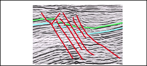