GONDWANA RECONSTRUCTION AND DISPERSION
Maarten de Wit, Margaret Jeffrey, Hugh Bergh, and Louis Nicolaysen, University of Witwatersrand
Search and Discovery Article #30001 (1999)
Adaptation for online presentation of supplemental maps, along with textual revision, that accompanies AAPG’s GEOLOGICAL MAP OF SECTORS OF GONDWANA, 1988.
- Individual animation frames:
- Anomaly M1 (115 Ma).
- Anomaly 34 (80 Ma).
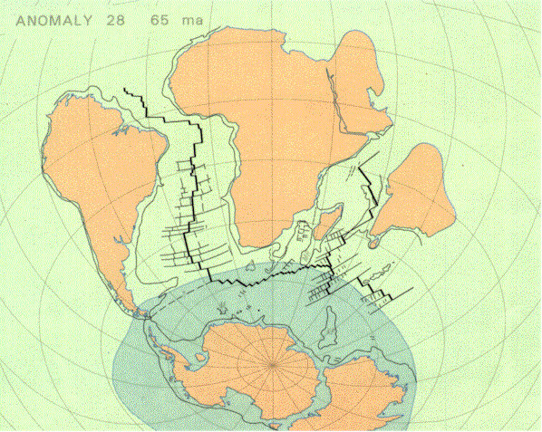
- Anomaly 28 (65 Ma).
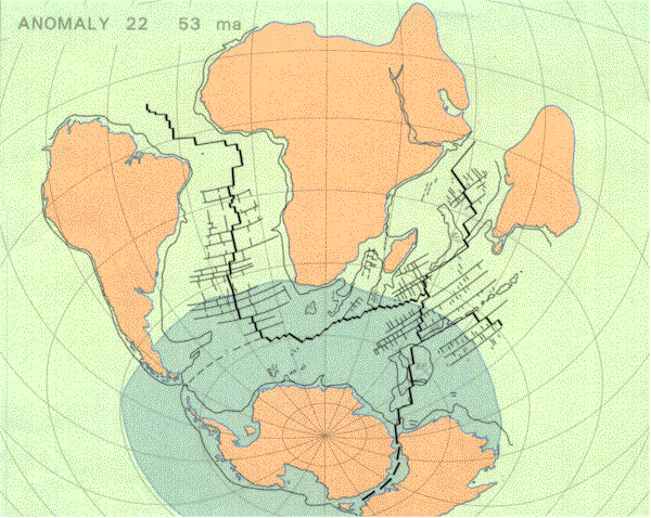
- Anomaly 22 (53 Ma).
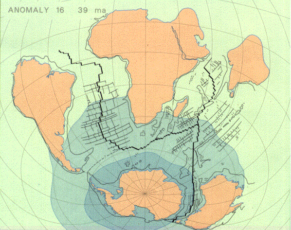
- Anomaly 16 (39 MA).
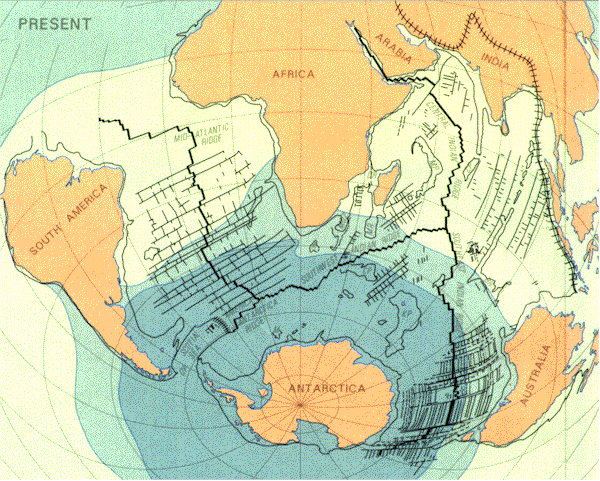
- Present.
THE CONCEPT OF GONDWANA
The name "Gondwana" was suggested in 1872 by Medlicott (1) of the Geological Survey of India for a sequence of nonmarine sedimentary rocks. He took the name from the ancient kingdom of the Gonds, one of the principal aboriginal tribes believed to have inhabited a large part of central India in which the most complete sequence of these rocks is found.
This original type-section of Gondwana strata forms a more or less continuous sequence from upper Carboniferous to Early Cretaceous. An unusual and distinctive fossil plant - GLOSSOPTERIS characterizes these sediments. Subsequent studies of the fossils and the character of the sediments have shown the existence of similar rock formations in South Africa, South America, Antarctica, Australia, Malagasy and other areas, all of which contain common flora and fauna; it is now possible to correlate the succession of fresh-water sedimentary strata, beginning in the late Paleozoic and continuing well into the Mesozoic, in these widely separated areas. The Austrian geologist Eduard Suess (2) explained such observations in 1885 by stressing the past unity of three of these continental masses within a supercontinent.
Thirty years later, the German scientist Alfred Wegener extended Suess' concept to include Australia and Antarctica, after Glossopteris had been discovered by Wilson and Bowers during Scott's 1910-1913 Antarctic Expedition (3). The early works referred to the supercontinent as Gondwanaland; today earth scientists prefer Gondwana.
GONDWANA AND CONTINENTAL DRIFT
During the first forty years of this century, very important contributions from geologists such as E. Suess in Austria, F.B. Taylor in the USA, A. Wegener in Germany, B. Choubert in France, A. Holmes in Britain and A. du Toit in South Africa, gave increasing credence to the idea of Gondwana as a southern supercontinent and to the allied notion of mobile continents, or continental drift. They noted the wealth of geological observations which could be explained simply by northward movement of the southern continents and India, away from the former heartland of Gondwana. The late 1920's and 1930's saw widespread discussion and debate about the matter; in 1926, for example, AAPG sponsored a symposium and published a symposium volume which included many views opposing continental drift (4). The debates of this period were influenced by the forceful opposition of scientists, mainly in the northern hemisphere, who were impressed by Jeffreys' arguments (5) that the strength of rocks at depth was too great to permit drift. In 1932 du Toit, on the other hand, concluded:
"the hypothesis of Continental Drift must now be regarded no longer as mere speculation, but as a definitely established and fundamental truth that can brilliantly and effectively reveal the past history of our Earth"(6).
GONDWANA AND PLATE TECTONICS
With a great new endeavor, marine geoscience, which arose during the two decades 1947-1967, earth scientists began to gather information about the nature and history of the earth's crust below the deep oceans. During this period, key discoveries that led to general acceptance of seafloor spreading, correlation of mid-oceanic magnetic anomalies and plate tectonics had a revolutionary impact on the understanding of Gondwana and its history.
RECONSTRUCTION OF GONDWANA IN PREPARATION OF AAPG’S GEOLOGICAL MAP OF GONDWANA
The first very carefully considered reassembly of Gondwana was published by du Toit in 1937. This reassembly relied solely on geologic trends and fits of the continental margins. In the new reconstruction of Gondwana, there are two quite independent sets of quantitative constraints which allow us to go back, step by step, as in a motion picture, to the unbroken supercontinent.
First, marine geophysical constraints: points on the plates must follow small circles parallel to the flow lines (delineated by fractures in the oceanic crust) when tracking the history of a particular section of oceanic floor. The time at which that section of ocean floor formed is determined by the age of its magnetic anomalies. Secondly, paleomagnetic constraints: on each of the Gondwana continents, magnetization imposed on rocks during the past 150 million years can be measured and, in principle, be dated. These measurements yield for each continent an Apparent Polar Wander Path (APWP): it tracks the moving position of the earth's rotation pole, relative to the continent, through the 150 million year period. The motion picture of the moving continents of Gondwana must satisfy these APWP's.
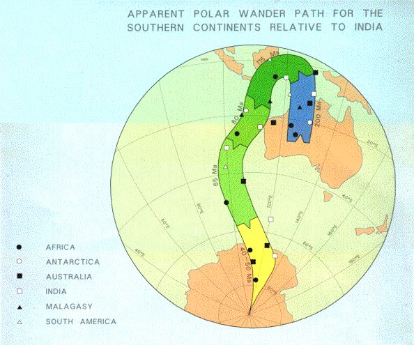
In 1979, a group of scientists from five different continents met at a REUNITE GONDWANA Workshop. An important task for the Workshop was to test the mutual consistency between paleomagnetic data (generated from continental blocks) and seafloor spreading data (generated from the ocean basins). To achieve this, M. McElhinny and B. Embleton from Australia brought to the Workshop tables listing the latitude and longitude of the paleomagnetic poles at specific times for the Gondwana continents; marine geophysicists - J. Sclater, J. LaBrecque, I. Norton, H. Bergh and P. Barker - brought up-to-date magnetic anomaly and fracture zone findings for the Cenozoic and Mesozoic floor of the southern oceans. The results are shown in Figure 1. The paleomagnetic data and the rules of the exercise are published elsewhere (7).
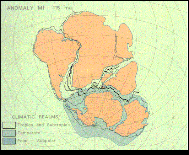
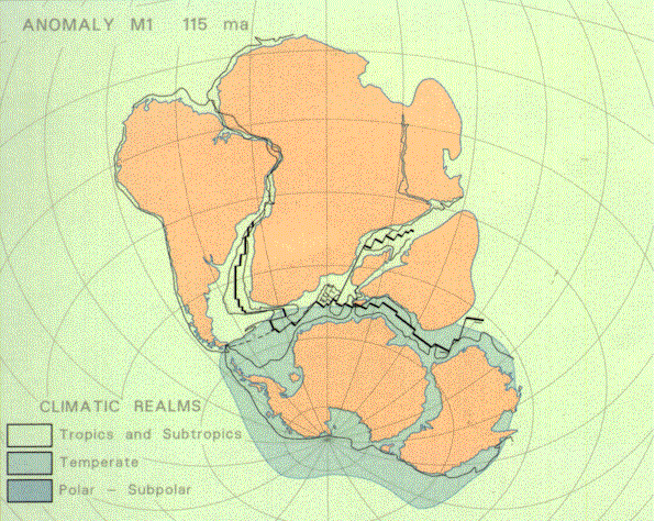
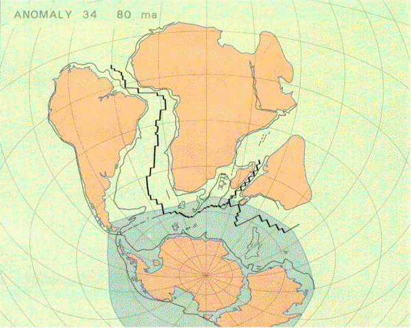
India was selected as the reference continent since it exhibits the most detailed APWP, having drifted about 50º of latitude since breakup. The paleomagnetic data from all continents exhibit a consistent trend in the form of a narrow envelope for the period representing the "fit" through to the mid-Tertiary. Paleomagnetic poles for the five discrete time intervals of this APWP (Fig. 1), correspond to the finite positions of the continents according to the marine magnetic anomalies at times 115 Ma (Fig. 2A), 80 Ma (Fig. 2B), 65 Ma (Fig. 2C), 53 Ma (Fig. 2D), and 39 Ma (Fig. 2E). The reconstructions corresponding to these specific anomalies are depicted in the animated, or time-slice, sequence (Fig. 2A-2F). Thus, it was demonstrated that currently available paleomagnetic data from the continents are consistent with the history of Gondwana dispersal recorded by marine magnetic anomalies. As a consequence, there was remarkable agreement on an overall reconstruction of Gondwana circa 150 million years ago: in very general terms, the 1937 du Toit (6) and the 1970 Smith-Hallam (8) reconstructions were vindicated.
When the implications of the seafloor-spreading data are rigorously examined, there is an outstanding problem with regard to the "overlap" of the Antarctic Peninsula and the Falkland Plateau, a continental extension of South America. Despite continued evaluation of ocean floor data from the Scotia and Weddell Seas, which have become available since the 1979 Workshop, a unique solution to this overlap problem has not been found (9-13).
COMPILATION OF AAPG’S GEOLOGICAL MAP (1988)
The positions of the continents were initially charted at a 1:5 million scale on an equal area projection of Gondwana centered at 20ºS, 40ºE, with Africa fixed in its present day position. Rotations (14-17) were performed and plotted; digitized coastlines were redrawn by hand, and geological data were similarly transformed from existing maps published at a variety of scales and projections. The map was then reduced photographically to the 1:10 million scale. To maintain optimum accuracy of Gondwana geology, there has been little attempt to strip the supercontinent of its post-dispersal cover.
Like many geological maps, this map is primarily an "age" map (18); the oldest preserved rocks in Gondwana are about 4000 million years old.
ACCURACY OF THE RECONSTRUCTION; ITS DIFFERENCES FROM OTHER GONDWANA MODELS
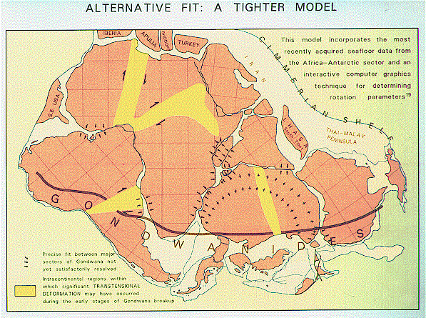
While the quantitative plate tectonic approach to the reconstruction of Gondwana represents a major scientific advance, its capacity to deal with distortions that might have occurred in the continents prior to the seafloor-spreading stage is very limited. Such crustal distortions of Gondwana are now known to have occurred both in the form of crustal stretching and transcurrent faulting, particularly close to the margins of thc present day continental fragments. This extensional phase may have started up to 200 million years prior to the first major onset of the present seafloor-spreading regime about 150 million years ago, the time represented by the map reconstruction. What are the requirements for determining the degree of crustal extension that preceded the seafloor-spreading stage in Gondwana's dispersal? First, a thorough knowledge of the stratigraphy and deformation of the sediments on the continental shelves and secondly, a clear understanding of the structure of the crust which underlies them. When the key extension parameters are thus determined and various extension episodes carefully dated, it will be possible to quantify a "tighter" fit of Gondwana, with a considerable reduction in the gaps between the reconstructed continents. One possible 'tighter" model (Fig. 3) was constructed using interactive computer graphics and an ocean-floor data set (19). The continents were rotated using the same principles as used for the geological map, followed a tightening-up of the mosaic to yield the most aesthetically pleasing fit without violating known geological constraints. Some differences between the reconstruction of the geological map and the map in Figure 3, which is not necessarily the best scientific fit, can be accounted for by the assumed crustal stretching along continental edges as well as deformation within zones of intracontinental shear (Fig. 3), In this model (compared to the geological map), India fits more snugly around the coastline of Antarctica, and Sri Lanka remains in its present day position relative to India. A large section of India and Burma has been removed, suggesting either that this part of the Indian subcontinent is underlain by oceanic crust, or that it was added to this continent following the break-up of Gondwana.
MARGINS OF GONDWANA
Gondwana was bound by two different types of margins. The southern margin, from Colombia to Papua New Guinea, was an active mountain system containing mountain chains of the types seen today along North and South America; large stretches were probably similar to the Andes, while other parts were more like the Basin and Range province and the Cordilleran ranges of North America. Convergence and/or strike-slip translation between the seafloor of the Proto-Pacific Ocean and Gondwana continents have been documented back to at least 150 million years ago. Similarly, during much of the Paleozoic and probably into the Precambrian as early as 800 Ma, Gondwana's southern margin experienced a long history of convergent or Cordilleran-type tectonics. The exact location of this active ocean-continent boundary and its locus over this lengthy period of time, are not known in detail. However, the general disposition of a late Paleozoic-early Mesozoic orogenic belt was outlined by du Toit (6); he recognized the stratigraphic and tectonic continuity of this fossil mountain system, here referred to as the GONDWANIDES. One immediate implication of this reconstruction is the great variation in width across the Gondwanides, from less than 500 km in southern Peru to more than 1200 km as measured from the southern Chile-Antarctic Peninsula paleo-trench across to the Cape Fold Belt-Ellsworth Mountain system, which marks the farthest inland edge or foreland thrust belt of this orogenic belt. Such a variation in width is directly comparable to that of the Cenozoic mountain chains and intermontane basins along the Pacific margin of the Central and North American plate. The geology of the Gondwanides may be a manifestation of a history of convergent plate interactions as complex as that documented along the Pacific plate margins of the Americas during the Cenozoic.
The tectonic history along the convergent margins of Gondwana and its fragments is one of tectonic erosion, accretion, extension and compression, alternating both spatially and temporally throughout the Phanerozoic. This compounds the problems of correctly reconstructing the distorted geology of the southernmost margin of Gondwana.
The northern margin of Gondwana was entirely different; from the early Paleozoic onward it resembled in many respects a passive margin like those seen today along the Atlantic ocean. No mountain belt existed, but instead stable, wide continental shelves and shallow seas straddled the margin of Gondwana from Northern Africa to Papua New Guinea. To the north lay a great triangular ocean (Proto-Tethys; see inset, upper right). The stability of this northern margin of Gondwana broke down in the mid-Paleozoic. From that time onward, small continental blocks (or microplates) began to separate from Gondwana, drifting northward to be deformed as they welded onto Laurasia. The recognition that this calving process was initiated in the Paleozoic and continued into the Mesozoic and Cenozoic led to a proposal that a Tethys-like ocean (Paleo-Tethys) existed before the well-documented Mesozoic Tethys opened in the wake of the earlier phase of northerly dispersed microplates (collectively referred to as the Cimmerian continent) (20). This process was later repeated when Tethys also closed during the Mesozoic by the northward dispersion of small Gondwana fragments, now embedded in places like southern Europe, Turkey, Iran, Afghanistan, Tibet and Malaysia. Many of the microplates were no longer part of Gondwana by 150 Ma, and their original shapes and dispositions are also still a matter of considerable debate (21. Even southern Tibet, which had already rifted-off Gondwana by about 250 Ma, may not be in its original Gondwana position. The restoration of the northern margin of Gondwana remains an enormous challenge: e.g., it requires the unstraining and reconstruction of the northern margin of India, now crumpled up as the Himalayan mountains and possibly partly buried beneath Tibet, and it requires the unraveling of complex internal deformations superimposed on the microplates during their evolution.
In summary, on a broad scale a clear picture of tectonic-asymmetry has emerged from the study of Gondwana's margins: along the south, subduction-tectonics was prominent; along the north a process of calving-tectonics dominated.
FORMATION OF GONDWANA
Gondwana comprised a mosaic of many highly varied Precambrian terrains, separated by late Proterozoic-early Paleozoic orogenic belts; the early history of these belts, particularly the transcontinental belts of Africa (named the Pan-African belts) (22) can be traced back in time to about 1000 Ma. These belts can be traced from Africa into South America, Antarctica and Australia. The dominant tectonic activity of these belts took place between 800-450 million years ago. It is thought by many geologists that these belts contain suture zones along which various types of late-Paleozoic ocean basins closed. According to these scientists the orogenic belts may thus represent welds between large and small scale fragments that collided in the late Proterozoic-early Paleozoic and fused together to form Gondwana. It has long been observed that large regions of the intervening Precambrian terrains have undergone extensive thermal rejuvenation between about 600-450 million years ago: it is probable that this period coincides with the culmination of collisions, welding and rapid uplift of the building blocks of Gondwana.
BREAKUP OF GONDWANA BREAK UP; ITS CONSEQUENCES
During the Paleozoic the interior of Gondwana was landlocked and erosion was leveling the Precambrian terrains. By the early Permian, earth stresses had begun to strain the continental crust and rifts developed in response to regional extension. The calving of microplates along the northern margin of Gondwana was well under way, and by the Permian a large extensional fault system had penetrated deep into the interior of the supercontinent. These faults developed into a major rift system along the (present) east coast of Africa. The presence of marine Permian sediments in Malagasy indicates that marine waters had penetrated over 1500 km into Gondwana along the rift axis. The outcrop pattern of Permian-Triassic rocks on this map outlines intermittent remnants of this narrow basin. From Malagasy, the rift system propagated south-westward toward the Falkland Plateau region, documented by the progressive southward advance of marine fossils (23). In this far southern section, rifting operated in concert with widespread volcanicity over an extended time span of some 80 million years before the onset of seafloor spreading.
In many instances Gondwana's old intracontinental welds preferentially formed the foci for the birth of the new intercontinental oceans. The initial separation started about 150 million years ago (Late Jurassic) essentially as a two-plate system, with spreading between western Gondwana (Africa-South America) and eastern Gondwana (Antarctica-India-Malagasy-Australia-New Zealand). The next phase in the break-up was more complex due to simultaneous rifting between Africa and South America and between (Antarctica-Australia) and (India-Malagasy) at about 135-120 Ma (Early Cretaceous). Australia did not drift away from Antarctica until much later (95-80 Ma, Late Cretaceous), approximately at the same time as the opening of the Tasman Sea. These events coincided with the separation of greater New Zealand from Australia-Antarctica and the final separation between India and Malagasy. Seafloor spreading in the Red Sea and the Gulf of Aden did not occur until much later (14-10 Ma). The break-up history of the smaller continental fragments of West-Antarctica can be traced back at least as far as the earliest Cretaceous; it is still continuing today with active spreading in the Scotia Sea and in the Bransfield Strait which started rifting in the Pleistocene.
Throughout the southern continents the intrusion and extrusion of vast volumes of mantle-derived magma, in the form of layered intrusions, sills, dikes and lavas, broadly overlapped in time with the separation history of Gondwana. The Karoo basalts of southern Africa (220-130 Ma, with a peak at ca.190-180 Ma), the Parana basalts and the coastal ophiolites of southern South America (about 120 Ma) the Dufek Massif, the Ferrar dolerites and the Kirkpatrick basalts of Antarctica and the Tasmanian dolerites (180-160 Ma); the Deccan Plateau basalts of India (65 Ma); and the basalts of Ethiopia (50-0 Ma) are the best known examples. This period of mafic igneous activity also coincided with large-scale chemical alteration of the mantle beneath central Gondwana and also with an extended period of intermittent kimberlite intrusions (240-60 Ma) (24). There has been a long standing discussion among earth scientists about a possible cause and effect relationship between the break-up of Gondwana, these vast volcano-plutonic igneous provinces, and the associated mantle disturbances.
The close spatial and temporal relationship of the magmatic province in south-central Gondwana with the calc-alkaline tectono-magmatic activity along the Gondwanides has led several workers to suggest a causal relationship between subduction and Gondwana fragmentation. One attractive model (25) proposes that the vast volume of oceanic crust that must have been subducted (and hydrated) beneath Gondwana caused significant deformation (alteration) in the mantle below this lithospheric cap; in turn, this led to the invasion of molten mantle into the crust to force separation of Gondwana's fragments. In this framework a close link between the subduction process and seafloor spreading remains an attractive hypothesis of fundamental geodynamic significance.
From geologic and paleomagnetic evidence it is known that central Gondwana drifted from a polar region to equatorial latitudes between the mid-Paleozoic and the early Mesozoic. Because the radius of today's earth is less at the poles than at the equator, the physics of Gondwana fragmentation should incorporate the stresses developed within this rigid supercontinent as it drifted towards a region with an increasing curvature. This is the essence of a concept known as membrane tectonics (26). Such a purely mechanical model cannot account for all the geological observations associated with the break-up of Gondwana, but the underlying principle, that bending stresses in the lithosphere played an important role, still deserves closer scrutiny.
Following the break-up of Gondwana, new seaways were established and old land-bridges between continents slowly destroyed. These events had major impacts, not only on the mobility of land and marine fauna, but also on their distribution with respect to changing climates and sea water temperatures. The final separation of Antarctica from all its surrounding fragments, for example, created for the first time a complete circumpolar ocean current, which totally altered the world's ocean-water circulation pattern (27).
There is ample evidence that the fragmentation of Gondwana affected the hydrosphere and the atmosphere (27). Clearly, there is a relationship between the incremental break-up of Gondwana and the dynamics of the ocean-water circulation, which in turn must have affected the world's climates. Similarly, the atmospheric circulation was probably significantly altered by the break-up of the long Gondwanides mountain system, which acted as a protective wind and precipitation barrier for the interior of Gondwana (28). All this and the volcanic activity associated with dispersion must have exerted notable forces on the biosphere.
In summary, the break-up of Gondwana was a major event in the history of the planet, with profound consequences for its inhabitants and their future.
GONDWANA IN A GLOBAL PERSPECTIVE
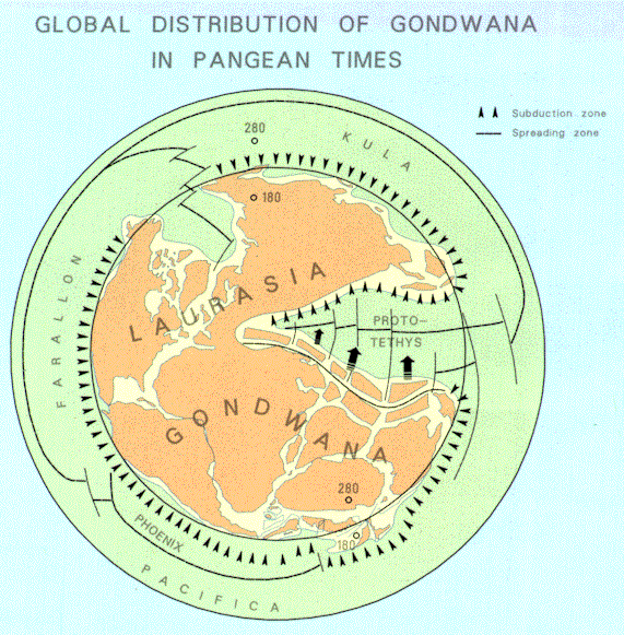
When the continents of the southern hemisphere were united as Gondwana, the global distribution of continental lithosphere relative to that of oceanic lithosphere was very different from that of our planet today. Moreover, some 260 Ma, Gondwana collided along its northwestern margin (from Venezuela to Morocco) with Laurasia, another ensemble of continental fragments, now dispersed across the northern hemisphere. These two giant continents remained welded together until the opening of the central Atlantic some 100 million years later. Thus, for a relatively short period of about 2% of the earth's history, almost the entire stock of the world's continental lithosphere was gathered as one united supercontinent, known as Pangea. This landmass must have covered almost an entire hemisphere of the earth, as shown in Figure 4. This diagram, redesigned from the work of three independent groups of geoscientists (29-31), vividly illustrates the concentration of land masses into one hemisphere (within the inner circle) surrounded by oceanic plates. The deep sea or the "opposite side" of the globe (displayed on this diagram as the outer rim) protrudes into the land-hemisphere as the embayment of Proto-Tethys.
Imagine most of the western hemisphere of our planet covered by one rigid granitoid shell: would this be a stable world, or would this asymmetric distribution of light lithosphere affect first-order characteristics of planet Earth? Could it alter the earth's shape (the geoid), or its rotation parameters or its internal dynamics? Closer inspection of the diagram also reveals that Pangea was almost entirely surrounded by subduction zones along which the descending oceanic lithosphere increasingly dehydrated and partially melted with depth. Imagine now the continuous input of oceanic lithosphere into a conical mantle sector covered by a giant continental lithospheric cap under radial compression. Would such a cap have acted as an efficient barrier to ascending fluids expelled from the descending oceanic lithosphere? Might it also have provided effective insulation of heat from such a large mantle domain? If so, the entire configuration should have drastically altered the global heat flow patterns. Seen in this light, the scenario must have evolved into an unstable planetary state (31-33). The continental lithospheric cap might have acted like the "lid on the pressure cooker" and the microplate calving-process in the Proto-Tethys as a "safety valve", but ultimately this hemispheric concentration of continents was doomed: the short life of Pangea bears witness. Could it be, therefore, that the formation of a supercontinent is indirectly the cause for its break-up and dispersal of its fragments? Vice versa, are the moving sectors of fragmented supercontinents destined to reassemble?
GONDWANA RESEARCH AND DATABASE
Over a century has passed since Eduard Suess took the bold step of naming our southern supercontinent and showing that the Gondwana concept was capable of explaining many disparate observations. Since then, many scientists have proved that an immense range of upper Paleozoic and Mesozoic geological events can be best understood within the framework of a Gondwana supercontinent and its Mesozoic dispersal. This map is a compilation of only the most basic data needed for Gondwana synthesis. The user of the geological map can also acquire the GONDWANA DIGITAL DATABASE (34) which contains all the information on the map in a form SIF/DGN) that can be handled by a number of computer systems and associated graphics devices.
Every field of geoscience research on Gondwana can be approached in the spirit of the plate tectonic motion picture: researchers can shift the continents about and integrate their own data bases. It should be possible to find new restorations which are properly constrained by new seafloor-spreading data and estimates of continental distortions, as well as to identify transcontinental areas where more detailed geological fieldwork could reduce the error of fit to within the 10 km scale now needed to improve Gondwana's restoration.
Geological fieldwork led to the concept of Gondwana, but a new science - marine geoscience - demonstrated its validity. In the same vein, continued field work and marine-based studies are presently benefiting from space-generated data and advanced data handling techniques. This map and the digital database can be used by anyone with an intercontinental spirit, a focus on Gondwana and a global approach to earth problems; because they present local geological data in a fresh framework, we hope they will stimulate progress.
REFERENCES CITED
Medlicott, H. B. and Blandford, W.T., A Manual of the Geology of India (Calcutta, Geol. Survey, India, 1879).
Suess, E., Das Antlitz der Erde (Temmsky, Wien, 1885).
Wegener, A., Die Entstehung der Kontinente und Ozeane (Friedr. Vieweg & Sohn, Braunschweig, (1915).
Van Waterschoot van der Gracht W.A.J.M. (ed)., Theory of Continental Drift: A symposium (American Association of Petroleum Geologists, Tulsa, 1928).
Jeffreys, H., The Earth (Cambridge University Press, 1929).
Du Toit, A.L., Our Wandering Continents (Edinburgh, Oliver and Boyd, 1937).
Embleton, B.J.J. and McElhinny, M.W., Earth Planet. Sci. Letters 58, 141-150 (1982).
Smith, A.G. and Hallam, A., Nature 225, 139-144 (1970).
De Wit, M.J., Tectonophysics 37, 53-81 (1977).
Dalziel, I.W.D. and Elliott, D.H., Tectonics 1, 3-19 (1982).
Storey, B.C., Dalziel, I.W.D., Garrett, S.W., Grunow, A.M., Pankhurst, R.I., and Vennum, W.R., Tectonophysics 155, 381-390 (1988).
Mitchell, C., Taylor, G.K., Cox, K.G. and Shaw, J., Nature 319, 131-133 (1986).
Grindley, G.W. and Davey, F.J., In: Craddock, C. (ed), Antarctic Geoscience, Int. Union Geol. Sci. Ser. 6, No. 4 15-30 (1982).
Rabinowitz, P.D. and LaBrecque, J., Jour. Geophys. Res. 84, (1979).
Norton, I.O. and Sclater, J.G., Jour. Geophys. Res. 84, 6803~830 (1979).
McKenzie D.P., Molnar, P. and Davies, D., Nature, 226, 243-248 (1970).
Parker, R.L., Hypermap program, Scripps Oceanographic Inst., La Jolla, California.
Harland, W.B. el al., A geologic timescale (Cambridge University Press, 1982).
Bergh, H., Jour.Geophys. Res. (1986); Royer, J-V., Patriat, P., Bergh, H.W., and Scotese, C.R., Tectonophysics, 155, 235-260 (1988).
Sengor, A.M.C., Episodes 8, 3-12 (1985).
See for example the debate between Audley-Charles M.G. and Allegre C.J. et al., in Nature 310. 165-166 (1984).
Kennedy, W.Q., Rep. Res. Inst. Afr. Geol. Univ. Leeds, 8, 48-49 (1964).
Thomson, M.R.A., In: Gondwana Five, 269-275 (Cresswell, M.M. and Vella, P. eds., Rotterdam, A.A. Balkema, 1981).
Erlank, A. (ed)., Petrogenesis of the volcanic rocks of the Karoo Province (Geol. Soc. S. Afr. Spec. Publ. 13, 1986).
Cox, K.G., Nature 274, 47-50 (1978).
Turcotte, D.L. and Oxburgh, E.R., Tectonophysics 35, 183-199 (1976).
Kennett, J.P.,Marine Geology (New Jersey: Prentice-Hall, 1982).
Barron, E.J., AAPG Bulletin 69, 448-459 (1985); Scotese, C.R. and Summerhayes, C.P., Geobyte 1, 28-42 (1986).
Kanasewich, E.R., Harskov, I. and Evans, M.E., Can. J. Earth Sci. 15, 919-955 (1978).
Smith, A.G., Hurley, A.M. and Briden, J.C., Phanerozoic Paleo-continental World Maps (Cambridge University Press, 1980).
Le Pichon, X. and Huchon, P., Earth Planet. Sci. Letters 67, 1234-1235 (1984).
Anderson, D.L., Nature 297, 391-393 (1982).
Nicolaysen, L.O., Du Toit Memorial Lecture (1985); Trans. Geol. Soc. S. Afr. (1986).