 Click
to view article in PDF format.
Click
to view article in PDF format.
Click to view posters in PDF format.
PSRegional Controls from Temporal and Spatial Distribution of Continental Slope and Abyssal Plain Reservoir Systems of the Gulf of Mexico Basin*
W.E. Galloway1, P. Ganey-Curry1, and T.L. Whiteaker1
Search and Discovery Article #50226 (2009)
Posted December 11, 2009
*Adapted from poster presentation at AAPG Annual Convention, Denver, Colorado, June 7-10, 2009
1Institute for Geophysics, Jackson School of Geosciences, The University of Texas at Austin, Austin, TX. ([email protected]; [email protected]; [email protected])
By the beginning of Cenozoic time, the Gulf of Mexico had assumed its general configuration as a small ocean basin, created in the Late Jurassic and Early Cretaceous as a part of the greater Atlantic spreading history. Thus clastic sediment entered a basin with a continental slope and extensive abyssal plain. In the late 20th Century, deep-water exploration began to test the hydrocarbon potential of these continental slope and subjacent abyssal plain depositional systems. A succession of major plays ensued, beginning with the “Flex Trend” discoveries in Plio-Pleistocene slope apron turbidite reservoirs, and culminating most recently in giant-field discoveries in Paleocene abyssal submarine fan systems. Regional mapping of the deep Gulf basin reveals several key attributes of the known and potential reservoir systems:
- Approximately two-thirds of the sediment entering the Gulf Basin was ultimately deposited in continental slope and abyssal plain settings.
- The principal accumulation phases of deep-water strata, particularly sand-rich intervals, correspond closely with major phases of sediment influx into the basin from tectonically uplifted and/or erosionally rejuvenated sources on the North American continent.
- The geographic location of slope and basin depocenters was determined by the sites where major fluvial systems draining those sources entered the Gulf.
- Reservoir systems deposited by various gravity-mass-transport processes accumulated widely within major offlapping continental slope aprons and as large submarine fan systems on the paleo-abyssal plain.
- Contemporaneous gravity tectonic domains further accentuated partitioning of sediment among shelf margin, continental slope, and basinal systems.
- Both seismic facies mapping and ODP drilling of the Quaternary Mississippi fan demonstrate that fan systems are quite capable of and have repeatedly distributed sand hundreds of kilometers beyond the contemporaneous shelf margin.
|
|
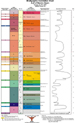
Setting the Stage By the beginning of the Cenozoic, the GOM basin was a small ocean basin with a broad northern coastal plain/shelf, continental slope, and deep abyssal plain (Galloway, 2008). The northern continental slope and adjacent basin floor was bathymetrically irregular due to salt deformation at Louann level. Asymmetric crustal stretching likely created an irregularly south-sloping gradient across the basin floor, with the deep basin center displaced toward Yucatan. Following the cataclysmic Chicxulub impact event at the T-K boundary, the northern Gulf margin remained regionally flooded (Midway/Porters Creek formations); sediment accumulation rates were low; and sediment consisted dominantly of mud and marl. Beginning at about 61 Ma, the first of a succession of depositional episodes, the Paleocene Lower Wilcox, began the process of continental margin offlap and basin filling. Eighteen genetic stratigraphic sequences that are bounded by regional condensed strata, transgressive marine beds, and/or paleontologic markers record Cenozoic depositional episodes (deposodes) of the northern GOM basin (Figure 1). All deposodes prograded the continental margin along some part of the northern or northwestern Gulf rim (Figure 2). Eleven deposodes efficiently focused bypass of sediment to the basin floor, constructing large, long-lived submarine fan systems on the abyssal plain.
Approximately two-thirds of the sediment entering the northern GOM was ultimately deposited in continental slope and abyssal plain settings. Throughout the Cenozoic, the GOM has typically been oversupplied with clastic sediment. Around major fluvial/deltaic depocenters and adjacent shore zones, supply has commonly outstripped creation of accommodation volume by loading and compaction subsidence. The representative cross section of the north central Gulf basin of Peel et al. (1995) provides a scaled illustration in two dimensions of this important volumetric relationship (Figure 3). The lower section is colored according the principal depositional setting. For Cenozoic strata: yellow = continental platform (coastal plain, delta, and shore zone) facies; uncolored = continental slope aprons and thin shelf mud tongues; pink = abyssal plain facies. Areas of each color are subequal. Extrapolation to three dimensions suggests subequal volumes for each facies association in the northern Gulf basin. More than 2/3 of the total area/volume consists of sediments deposited seaward of the contemporary shelf margin. In a supply-dominated basin margin, such as that of the northern GOM, bypass of sediment to the basin is the rule; unusual conditions are required to interrupt deep marine accumulation. Such conditions prevailed during the relatively brief spans of regional transgressive flooding that define deposodes.
Reservoir systems deposited by gravity transport processes accumulated within both offlapping continental slope aprons and submarine fan systems on the paleo-abyssal plain. Gulf continental slope and basin-floor settings exhibit a variety of depositional systems and elements (Figure 4). Important reservoir facies occur within prograding slope aprons, principally delta-fed aprons, but also in shelf-fed aprons, retrogradational aprons, and submarine canyon fills. At the slope-apron base, sandy turbidite-channel and lobe deposits may spill onto the adjacent basin floor as unfocused basin-floor aprons. Focused supply of sediment to the basin floor though erosional canyons, structurally aligned conduits, or bathymetric troughs builds aggradational abyssal plain fans that may spread hundreds of kilometers across the basin. Additional systems include mega-slide complexes and their mass-transport complexes, abyssal plain hemipelagic and distal muddy turbidite sheets, and contourite drifts. The modern Gulf continental margin and basin floor displays this diversity of depositional systems.
Accumulation of sand-rich deep-water facies occurred during the episodes of sediment influx from tectonically uplifted and/or climatically rejuvenated sources on the North American continent. As suggested by Figures 1 and 2, different deposodes display different volume/rates of sediment supply to the Gulf. In particular, the Lower, Middle, and Upper Wilcox (LW—UW), Frio (OF), and Neogene (LM1—PS) deposodes were times of high rates of sediment supply as reflected in cumulative magnitude and rate of continental margin outbuilding (Galloway, 2005a), volume rate of delta and shore-zone system accumulation (Galloway 2002), and overall sediment volume estimates for the northern GOM. Well developed wedges of slope-apron deposits characterize all major deposodes (Figure 5). Indeed, this is intuitively obvious given that seaward advance of the shelf margin inherently requires a depositional foundation in the form of a prograded slope apron. Abyssal plain-fan systems are features of most, but not all, major deposodes. Notable is the absence of fans in middle Cenozoic Frio (OF) and early Miocene (LM1). Fan systems are also absent from the minor middle and late Eocene QC—JS deposodes. Sediment supply to the northern GOM arrived primarily through a shifting suite of large extra-basinal rivers (Galloway, 2005b). Sediment yield from the drainage basins of these large rivers reflects source-terrain tectonic uplift and/or, in the Late Cenozoic, climate change. Five tectonic phases within the North American plate directly impacted supply to the Gulf, and thus the temporal distribution of major slope and basin depositional systems (Figure 5).
The geographic location of slope and basin depocenters was determined by the sites where major fluvial systems draining those sources entered the Gulf. Large, extra-basinal rivers provided the bulk of sediment that entered the northern Gulf. Depocenters (Figure 6, gun sight symbols) typically lie within slope-apron prisms along areas of greatest shelf-margin progradation and at the base of the paleo-slope on the basin floor where large submarine fan systems are centered. Paleogeographic maps for Miocene and Plio-Pleistocene deposodes display typical paleogeographic relationships among the shelf platform, slope, and abyssal plain systems. Note that fan depocenters may be offset laterally from the fluvial/deltaic axes. This reflects the fact that cross-slope transport pathways are commonly localized, focused, and geomorphically complex.
Reservoir sand bodies deposited by gravity-mass-transport processes occur widely within continental slope aprons and submarine fan systems on the paleo-abyssal plain. Both slope-apron and fan systems contain turbidite sand bodies. Principal reservoir facies include incised channel, leveed channel, lobe, and sheet turbidite sand bodies. Sandy debris flow lobes may also occur. All are productive in the northern GOM. As shown in Figure 7, delta-fed aprons and adjacent segments of shelf-fed aprons contain dip-oriented belts of sandy turbidite facies. These sand-rich belts traverse multiple slope-minibasins. Plio-Pleistocene deposodes (which can be mapped in considerable detail with well data) display 7 to 11 such belts. Some belts extend to the slope toe and onto the adjacent basin floor; others terminate within the slope apron. In most deposodes a few adjacent turbidite flow axes combine to focus sediment onto the basin floor over geologically extended time spans, nucleating and constructing abyssal plain-fan systems.
Contemporaneous gravity tectonic domains profoundly affect partitioning of sediment among continental platform, slope, and basinal systems. Accommodation volume is controlled first and foremost by subsidence. Depositional loading of continental crust beneath the shelf-margin depocenter initiates flexural subsidence. The resultant pattern is relatively simple, forming a strike-elongate subsidence bowl. However, gravity tectonics profoundly overprints and modifies this simple geometry. Extension which is manifested in the shallow section by syndepositional normal faulting, causes enhanced subsidence along the continental margin. Salt evacuation from beneath areas of loading can cause additional subsidence of several thousand feet (e.g., Diegel et al., 1995). The middle Miocene (MM) deposode (Figure 8) illustrates the variety of patterns that can emerge. Along the Texas shelf, extension and canopy loading created a curvilinear depoaxis that closely parallels the prograding shelf margin. Enhanced subsidence accommodated more than 8000 ft (2500 m) of shelf/delta platform and upper slope strata along this belt. Most available sediment was effectively stored in the proximal slope. Beneath southeast Louisiana, a second MM depocenter lies within the Harang embayment, which is both a structural and depositional feature. Here, loading and evacuation of a shallow salt canopy caused several thousand feet of excess subsidence, again beneath the outer shelf/delta platform. However, sufficient overflow sediment remained to nourish a third depocenter on the northeast Gulf basin floor. This depocenter is comprised of the McAvlu abyssal fan strata (Figure 6A).
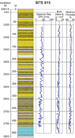
Both seismic facies mapping and DSDP drilling of the Quaternary Mississippi fan demonstrate that fan systems are quite capable of and have repeatedly distributed sand hundreds of kilometers beyond the contemporaneous shelf margin. Leg 96 of the DSDP program drilled, cored, and logged 9 sites along the length of the late Quaternary Mississippi fan. Results demonstrate important aspects of fan facies that have significance for interpretation and prediction of potential reservoir facies in older GOM abyssal plain-fan systems.
Regional GOM seismic lines image basin-scale deep continental slope and abyssal systems that remain untested by drilling, particularly in the western Gulf. Slope and basinal systems of the western GOM differ from the northern margin. There, the continental shelf is narrow; tectonic uplands were nearby, and fluvial drainage basins small. However, sparse seismic lines from the deep western Gulf suggest the presence of large abyssal fan systems (Figure 10). Mounded and channel-form reflections, as well as variable amplitudes, all suggest fan deposits in Miocene and possibly Eocene deposodes. Different styles of slope and basin development likely evolved on the western GOM margin, but there too, organized bypass of sediment to the basin floor created defined, long-lived fan systems.
Diegel, F.A., .F. Karlo, D.C. Schuster, R.C. Shoup, and P.R. Tauvers, 1995, Cenozoic structural evolution and tectono-stratigraphic framework of the northern Gulf coast continental margin, in M.P.A. Jackson, D.G. Roberts, and S. Snelson, eds., Salt Tectonics: a Global Perspective: AAPG Memoir 65, p. 109-151; also Search and Discovery Article #30006 (2001) (http://www.searchanddiscovery.net/documents/97021/index.htm). Galloway, W. E., 2002, Cenozoic evolution of sedimentation accumulation in deltaic and shore-zone depositional systems, northern Gulf of Mexico basin: Marine and Petroleum Geology, v. 18, p. 1031-1040. Galloway, W. E., 2005a, Cenozoic evolution of the northern Gulf of Mexico continental margin: Proceedings of 25th Annual GCS-SEPM Research Conference, Petroleum Systems of Divergent Continental Margins, P.J. Post et al. eds., CD. Galloway, W. E., 2005b, Gulf of Mexico Basin depositional record of Cenozoic North American drainage basin evolution: International Association of Sedimentologists Special Publication 35, p. 409-423. Galloway, W.E., 2008, Depositional evolution of the Gulf of Mexico sedimentary basin, in K.J. Hsu, ed., Sedimentary Basins of the World, v. 5, The Sedimentary Basins of the United States and Canada, Miall, A.D., ed.: The Netherlands, Elsevier, p. 505-549. O'Connell, C.E. Stelting, A.H. Bouma, et al., 1985, Drilling results on the lower Mississippi fan, in A.H. Bouma, W.R. Normark, and N.E. Barnes, eds., Submarine Fans and Related Turbidite Systems: New York, Springer-Verlag, p. 291-298. Peel, F.J., C.J. Travis, and J.R. Hossack, 1995, Genetic structural provinces and salt tectonics of the Cenozoic offshore U.S. Gulf of Mexico: a preliminary analysis, in M.P.A. Jackson, D.G. Roberts, and S. Snelson, eds., Salt Tectonics: a Global Perspective: AAPG Memoir 65, p. 153-175. Special “thank you” to the sponsors of the Gulf Basin Depositional Synthesis Project (GBDS) who have provided ongoing support for regional interpretation of Gulf history and for allowing publication of these results (click to view logos of the sponsors).
|
