Click to view poster in PDF format.
PSSatellite Imagery and Geological Interpretation of the Exumas, Great Bahama Bank - An Analog for Carbonate Sand Reservoirs*
Paul (Mitch) Harris1 and James Ellis2
Search and Discovery Article #50200 (2009)
Posted September 8, 2009
*Adapted from poster presentation at AAPG Annual Convention and Exhibition, Denver, Colorado, USA, June 7-10, 2009.
1 Chevron Energy Technology Company, San Ramon, CA ([email protected])
2 Ellis GeoSpatial, Walnut Creek, CA ([email protected])
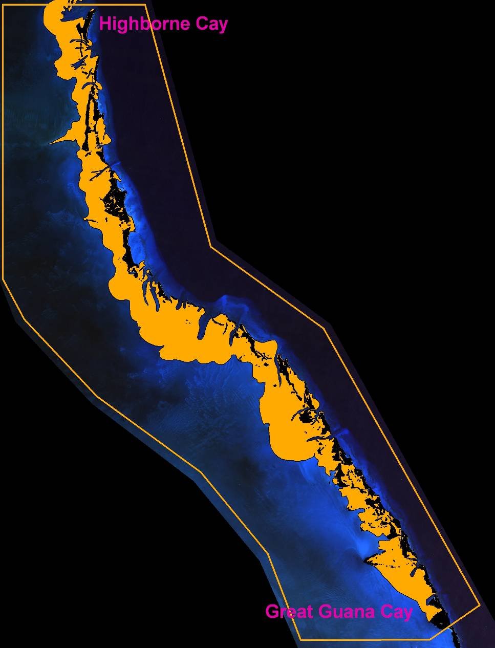
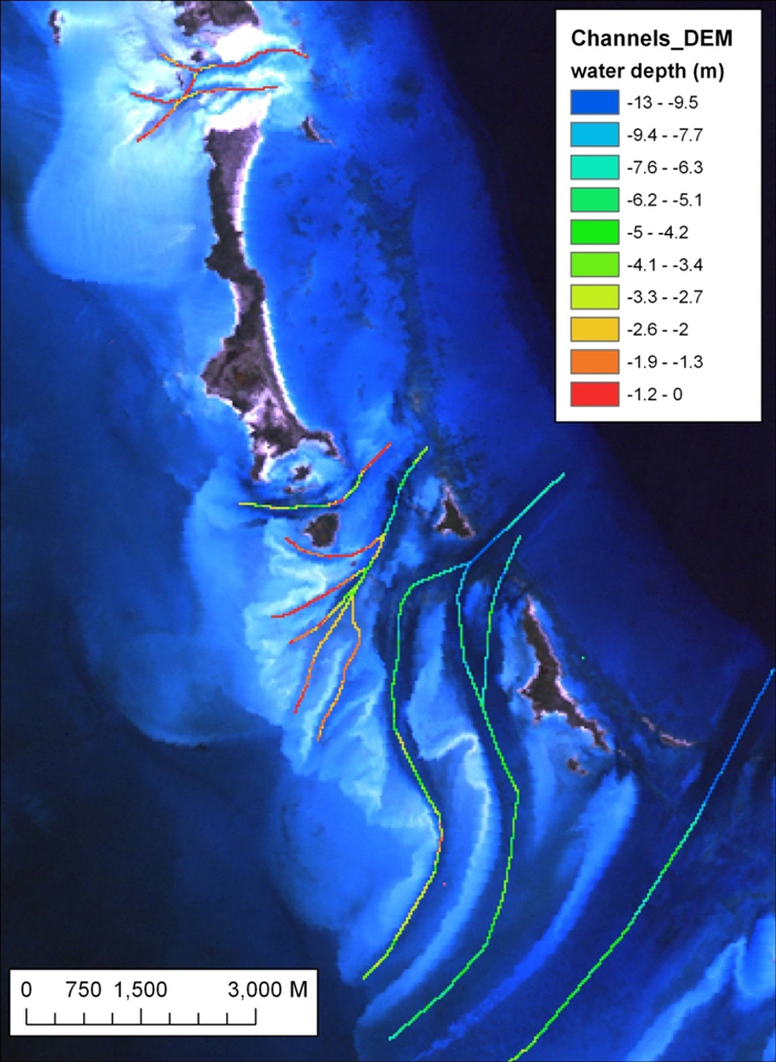
We use a set of processed satellite images, offshore/onshore (DEM), and interpretation maps organized into a GIS for geological interpretation of the Exuma Islands and surrounding carbonate sand bodies of Great Bahama Bank. The overall distribution of carbonate sands; i.e., total sand body, was interpreted by selecting different water depth intervals, and different portions were highlighted for visual analysis and morphometric measurements. We think such results add value to the characterization and modeling of carbonate reservoirs.
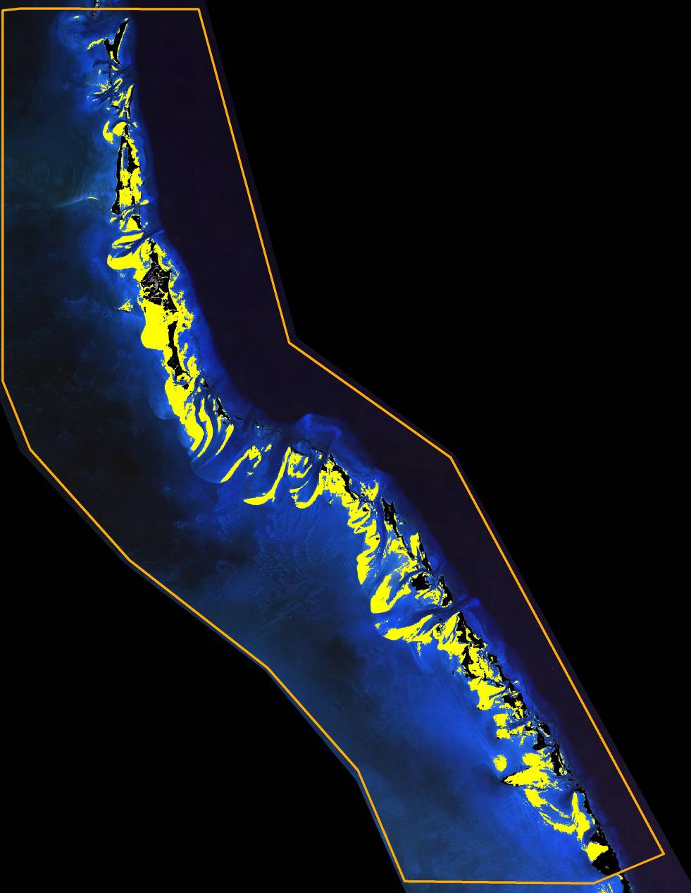
The shallowest sands (0 - 1.8 m water depth and likely producing the best reservoir) revealed geologically reasonable patterns of deposition and accounted for 37% of the total sand body. 48 out of the 617 shallowest sand bodies have areas larger than 100,000 m2. Their shape was evaluated using the form-factor shape of Russ (1999) wherein values approaching 1 are more circular and 0 are more irregular. The smallest, shallowest sand bodies have form factors from 0.15 to 0.6, whereas only 6 sand bodies larger than 100,000 m2 have form factors greater than 0.14, indicating larger sand bodies are relatively more irregular compared with smaller sand bodies. The largest, shallowest sand body (16 km2) is highly sinuous and has the lowest form factor of 0.0097.
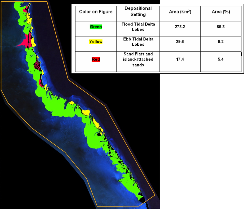
The total sand body was also divided into flood tidal delta lobes, ebb tidal delta lobes, and sand flats/island-attached sands. Flood tidal delta lobes comprise 85% of the total sand body. The average distance was 2.7 km +/- 1.5 km (with a range from 0 to 7.3 km) from any portion of the flood tidal delta to an ebb-flood dividing line. Fifty-two active tidal channels average 2.9 km and range between ~0.5 and 8.2 km in length. Flood tidal delta lobes average 900 m +/- 650 m from the tidal channels with sediment deposited in the lobes ranging in distance from the tidal channels between 0 to ~4400 m.
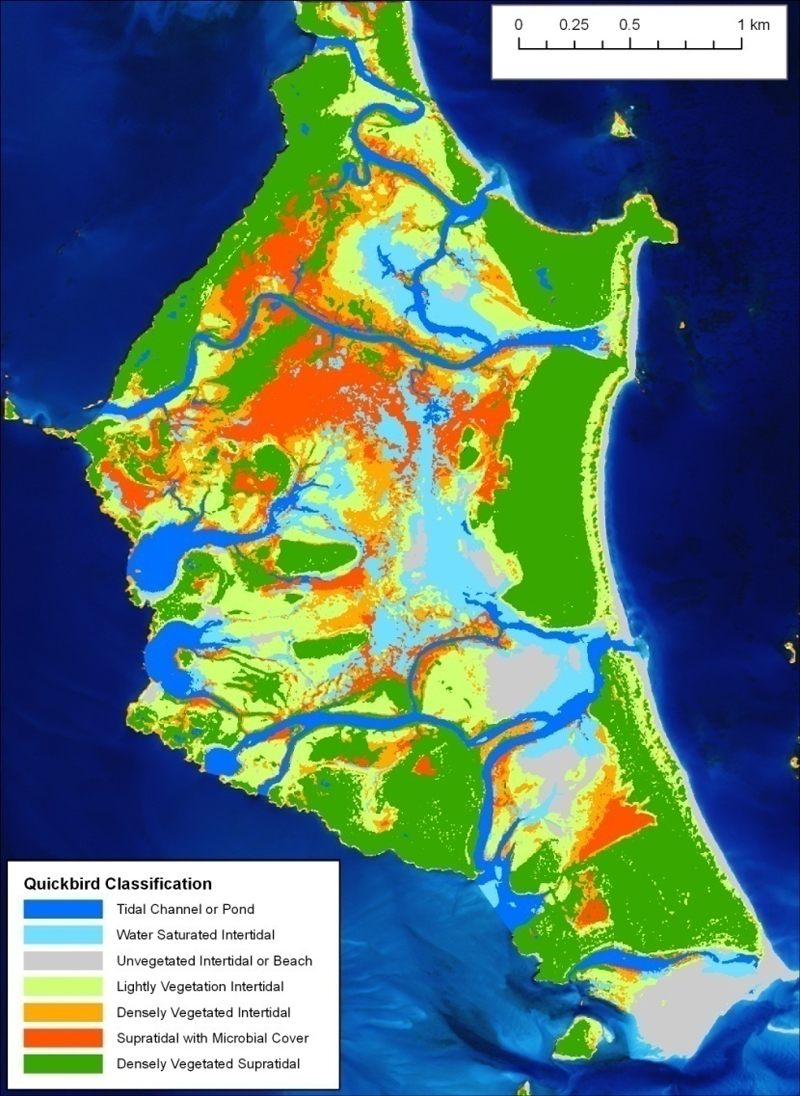
Interpreting Pleistocene and Holocene ridges from enhanced satellite imagery of a key island indicates 38% of the island is Pleistocene at the surface, and the Holocene ridges were deposited around the Pleistocene topography in a complex fashion. Integrating elevations with the interpretation map shows Holocene ridges have elevations from near sea level to 12 m (mean elevation of 7.7 +/- 2.5 m ) and Pleistocene landforms have elevations from near sea level to 19 m (mean elevation of 9.3 +/- 3 m).
|
|
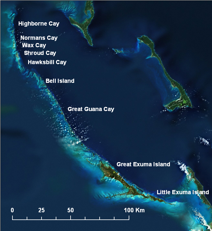
The Exumas portion of Great Bahama Bank is an area of continuing interest to researchers in modern carbonates, an important training venue, and a valuable modern analog for understanding facies patterns in grainstone reservoirs. We hope to promote this interest by making readily available a set of processed satellite images, an onshore/offshore digital elevation model (DEM), and numerous examples of how this data can be visualized and used with an emphasis on better characterization and modeling of carbonate reservoirs.
Exploration-Scale Insight
Reservoir Heterogeneity Insight
Reservoir Modeling Insight Quantitative relations like the following are essential for building facies-based models:
|