 Click to view presentation in PDF format.
Regional Mapping of Genetic Units in the Almond Formation, Greater Wamsutter Field, Southwest Wyoming: Phase II: What to Do without a Flooding Surface: Mapping the Coastal Plain*
Tina L. Gammill1, Alan J. Scott1, Natasha M. Rigg2, Benjamin Kessel2, Will D. Monn2, Mark L. Bacon1, and Austin J. Roelofs3
Search and Discovery Article #50158 (2009)
Posted January 30, 2009
*Adapted from oral presentation at AAPG Annual Convention, San Antonio, TX, April 20-23, 2008. See companion articles, Search and Discovery Article #50157 (2009), Phase I: A Visual Twist on an Old Approach: The Middle Main Almond Unit, and Search and Discovery Article #50159 (2009), Phase III: An Iterative Geostatistical Approach to High-grading Well Locations.
1 Anadarko Petroleum Corp, The Woodlands, TX. ([email protected])
2 Anadarko Petroleum Corp, Denver, CO.
3 North Coast Energy, Inc.
The Almond Formation is the primary production target in the greater Wamsutter area in the Washakie Basin. Phase I of this project used a triple-log "pseudoseismic" display to establish genetic intervals through correlation of major flooding surfaces in the middle, marine-influenced wedge of the Main Almond. The objective for Phase II was to correlate and map reservoir quality sands in the upper and lower Main Almond coastal plain/estuarine units where major flooding surfaces were lacking or absent. This extension adds potential reserves and improved commerciality of development wells.
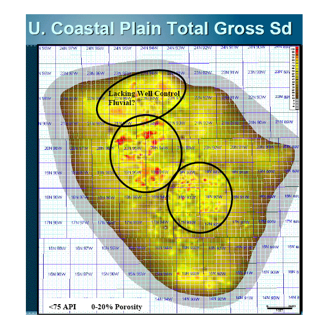
Depositional styles differ between the lower and upper Main Almond units; the nature of this style determined our approach. The lower Main Almond consists of large, stacked channel complexes encapsulated within coastal plain coals and estuarine mudstones. Correlations were based on laterally extensive coals and the erosional bases of the channel complexes. The upper Main Almond consists of smaller estuarine/fluvial channels, inter-channel splays, and estuarine deposits. Minor flooding surfaces were used to correlate in the down-dip extent of the field; these were replaced up-dip by laterally-extensive coals.
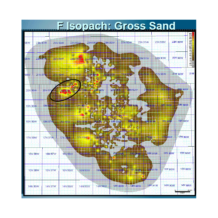
Three lower Main Almond intervals with thick estuarine and fluvial channel sand complexes were mapped. Mapping of these bodies shows reciprocal sedimentation of these complexes through time. Additionally, eight coastal plain intervals were mapped in the upper Main Almond unit.
This approach has proven to be a cost-effective method to regionally evaluate reservoir potential and facilitate developmental planning in a predominantly coastal plain environment. The integrated set of nineteen Almond genetic intervals forms the basis for stochastic reservoir evaluation and aid effective field development decisions.
|
|
Predictability of Coastal Plain Sand Reservoirs Anticipated depositional models
Resultant depositional models based on Phase II
Syndepositional faulting is significant
Haq, B.U., J. Hardenbol, and P.R. Vail, 1988, Mesozoic and Cenozoic chronostratigraphy and cycles of sea-level change, in Sea-level changes; an integrated approach: SEPM Special Publication 42, p. 72-108. Krystinik, L.F., and B.B. DeJarnett, 1995, Lateral variability of sequence stratigraphic framework in the Campanian and lower Maastrichtian of the Western Interior Seaway, in Sequence stratigraphy of foreland basin deposits; outcrop and subsurface examples from the Cretaceous of North America: AAPG Memoir 64, p. 11-25 Martinsen R.S., G.E. Christiansen, M.A. Olson, and R.C. Surdam, 1995, Resources of southwestern Wyoming, in Resources of southwestern Wyoming: Wyoming Geological Association 1995 field conference guidebook, p. 297-310. Jim Fuchs, Lee Petersen, Mike Weaver, Robbie Perry, and John McCartney.
|
