Click to view poster in PDF format (48 mb).
Or right click to download.
PSMagnitude of Tectonic Uplift Events Along Passive Margins Estimated
from Analysis of Base-Level Governed Erosion Surfaces*
Johan M. Bonow1 and Peter Japsen1
Search and Discovery Article #40414 (2009)
Posted May 22, 2009
*Adapted from poster presentation at AAPG International Conference and Exhibition, Cape Town, South Africa, October 26-29, 2008.
1 Geological Survey of Denmark and Greenland (GEUS), Copenhagen, Denmark
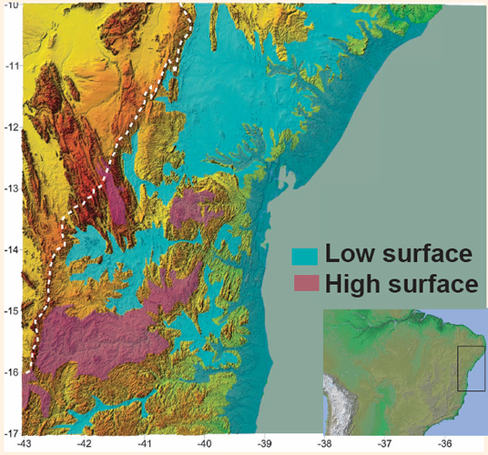
The magnitude of recent tectonic uplift events along the passive margins in the Atlantic domain is evidenced by the high elevation of base-level governed erosion surfaces of regional extent and low relative relief. The difference in altitude between the present elevation of such a plateau and the base level to which it developed reflects the amount of surface uplift since the surface was formed. The relief occasionally forms a series of steps resulting from multiple tectonic uplift events. Changes of the base level (uplift events) cause valleys to incise and the relief to rejuvenate. Consequently erosion surfaces will not survive for extended time in high-altitude positions. In West Greenland two erosion surfaces have been identified and the upper one cuts across basement and mid Eocene volcanics showing that this surface is significantly younger than the last, early Paleocene rift event in the area. The lower erosion surface is the evidence for a first phase of uplift, up to 1 km, prior to a later event, also up to 1 km, leading to the present stepped landscape. Scandinavia has two topographic domes with stepped surfaces. Uplift in the Neogene was 1 km for the Southern Scandes, while it was 0.5 km for the Northern Scandes. Northeast Brazil is dominated by two major erosion surfaces. The higher surface reaches elevations above 1 km and this altitude is probably due to Neogene uplift. The lower surface at c. 400 m a.s.l. is relatively well-preserved even where it cuts across strata prone to weathering. This indicates that it was affected by uplift and subsequent valley incision late, probably during the Plio-Pleistocene. These cases illustrate that geomorphological analysis of base-level governed erosion surfaces can be used to estimate the magnitude of uplift events.
|
|
Principles for Interpretation of Base-Level Governed Surfaces Two surfaces have been mapped on Nuussuaq, West Greenland (red and blue in Figure 4). They occur on tilted tectonic blocks and cut across mid-Eocene basalts and older rocks, thus younger than the latest rift event in the early Paleocene. In central Nuussuaq the surfaces are vertically separated up to 1 km, and the lower surface is at 1 km a.s.l. We interpret this as the result of two uplift events with a magnitude of 1 km each. The present elevation for the surfaces cannot only be the result of sea-level change or isostatic compensation of erosion. Note that the photo only shows part of the above section (green arrows in Figure 4). The lowest of the four stepped surfaces (green) is at about 500 m a.s.l. in the north, while it is at 1000 m a.s.l. in the south. This is interpreted to reflect differences in magnitude of the latest uplift event. The “high” surface in Figure 6 is preserved where it has developed across resistant rocks. The “low” surface is well preserved also in areas with easily eroded rocks. This indicates that the surface, which must be relatively late, has lost its contact to the base level to which it originally formed. Conclusions: Hydrocarbon Prospectivity
|