![]() Click to view article in PDF format
Click to view article in PDF format
Recent Discoveries Offshore Douala Basin*
Tiziana Luzzi-Arbouille1, Eric Schmid1 and Theodhora Piperi1
Search and Discovery Article #10185 (2009)
Posted April 14, 2009
*Adapted from oral presentation at AAPG International Conference and Exhibition, Cape Town, South Africa, October 26-29, 2008
1IHS, Perly-Geneva, Switzerland (mailto:[email protected] )
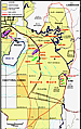
The Douala Basin is mainly located onshore and offshore Cameroon. To the west and southwest, it extends into the territorial waters of Equatorial Guinea.
Proven reservoirs are the syn-rift to transitional Mundeck Formation (mainly Lower Cretaceous), comprising non-marine sandstones and arkoses of fluvial origin, Upper Cretaceous Logbaba and Tertiary N’Kapa and Souellaba formations of mainly fan and channel sands enclosed in offshore slope and basin mudstones. Trapping styles are dominated by unconformity and stratigraphic types.
Since the first exploration activity in the 1950’s, 62 new-field wildcats have been drilled in the basin, of which 22 resulted in discoveries. Most of the activity has taken place in Cameroon as the first wells in Equatorial Guinea were drilled only in 2003. After a low level of activity in the 1990’s, exploration has intensified, mainly offshore. Since 2002, 14 new-field wildcats have been drilled in shallow and in deep waters, with a success ratio exceeding 40%. Most discoveries were made in Miocene sandstone reservoirs, which appear to be the primary target. The main hydrocarbon type is gas and condensate, but the presence of oil was confirmed in Coco Marine 1 in Cameroon and interpreted in the Benita I-2 well in Equatorial Guinea.
Hydrocarbon finds such as Belinda, Benita and Yoyo, fill to some extent the gap in the series of deepwater discoveries in this part of West Africa, between the Niger Delta to the north and the Rio Muni Basin to the south. Further exploration is planned offshore Douala Basin and development options are being reviewed. The newly-established LNG plant on Bioko Island could provide an outlet for the discovered gas.
|
Recent Discoveries Offshore Douala Basin
The offshore sector of the Douala Basin is currently experiencing a revival in exploration activity. Since 2002, 16 wildcats have been drilled. Half of them succeeded in finding hydrocarbons, mainly gas and condensate in Miocene sandstone reservoirs. Since 2007, six out of eight wells have been positive.
Basin Description
The Douala Basin covers some 26,500 sq km. About 70% is located offshore, half of which is in deep water. The basin lies mainly on- and offshore Cameroon. To the west and southwest, it extends into the territorial waters of Equatorial Guinea (Figure 1).
A number of geological features delimit the basin - the Cameroon Volcanic Line to the northwest, the Pan African Fold Belt to the east and the Kribi Fracture Zone to the south. The basin is believed to extend westward up to the Gabon-Douala Deep Sea Basin.
The Douala Basin is the northernmost of a series of basins located along the South Atlantic margin of Africa. The history of these basins began in Late Jurassic time as a series of northwest-southeast trending intra-cratonic rift basins formed in response to the separation of South America from Africa. The successive Neocomian and Barremian sequences record two major phases of non-marine sedimentation and rifting, which culminated in the formation of a regional peneplain toward the end of the period. The Late Barremian peneplain was flooded by marine deposits of Aptian age that include thick sequences of salt. This early basin history is unrecorded in the Douala Basin as wells generally do not penetrate sediments older than Aptian. Nonetheless, the thick section below the level of Aptian penetration suggests that the non-marine successions recorded in the basins to the south are also present in the Douala Basin. Salt occurs in the southern part of the basin. It is Cretaceous in age and is interpreted to be Aptian by analogy with its dated equivalent in Gabon. Subsequent deepening of the South Atlantic allowed marine waters to enter the basins, terminating the deposition of evaporites. Syn-rift faulting in the Douala Basin continued until the end of the Albian when the continental shelf was broken up into a series of fault blocks. Late Albian erosion of the tilted fault blocks marked the end of the syn-rift phase of basin development, and the subsequent deposition of onlapping Upper Cretaceous pelagic shales marked the beginning of thermal subsidence which continued throughout the Tertiary as the South Atlantic widened and deepened through sea floor spreading. The continued deepening of the Atlantic throughout the Upper Cretaceous and Tertiary provided an ever increasing gravitational impetus for the down slope salt movement which was strongly accentuated by up-dip sediment loading. The post-rift development of the Douala Basin differs from related basins in both Africa and Brazil in lacking significant carbonate platform deposits in the early post-rift section. Westward tilting of the basin combined with Oligocene withdrawal of the sea led to widespread erosion that included the development of erosional channels subsequently filled with marine Upper Oligocene and Miocene channel fill sands and turbidites. Progressive filling of the Douala Basin by westerly prograding sediment resulted in the present-day position of the shelf edge.
Proven reservoirs in the Douala Basin are the Mundeck Formation (mainly of Lower Cretaceous age) comprising non-marine sandstones and fluvial arkoses, Upper Cretaceous Logbaba and Tertiary N’Kapa and Souellaba formations of mainly fan and channel sands enclosed in offshore slope and basin mudstones. Trapping styles are dominated by unconformity and stratigraphic types. The hydrocarbon source rock has not yet been definitely recognized. The main contenders are a Lower Cretaceous lacustrine source, an early Upper Cretaceous marine source, and a Tertiary marine source (N’Kapa) (Figure 2).
The offshore Tertiary play, which is currently actively worked on by Noble Energy and BowLeven, displays the following stratigraphic elements: channelized turbidite sandstones of mainly Miocene age as reservoirs and intraformational shales as seals. So far, the extension of the play has been proven from Block O and MLHP-5 in the north (bordered by the Cameroon Volcanic Line) to Block I and PH-77 in the south, and it is likely to extend further down. The southwestern limit is not clearly defined and depends on how far down the slope turbidites could flow. The main hydrocarbons in this play are gas and condensate (Belinda, D-1R, Yoyo, Yolanda and Felicita discoveries), but oil was also encountered in Coco Marine and Benita. It is possible that to the southwest, the turbidite channel play progressively changes into a basin floor fan play which could also be highly prospective and distinct from the already postulated Cretaceous basin floor fan play.
According to BowLeven, operator of the PH-74 (Etinde) permit in Cameroon, the Cretaceous basin floor fan play is a possible analogue of the deepwater discoveries in Ghana, but in shallow water. Prospective reservoirs include basin floor wedge/fan shaped depositional units of late Cretaceous age, expected at a depth of about 4,000m and charged from an underlying Cenomanian-Turonian source rock interval. The volumetric potential of the structures is estimated to be much greater than slope prospects.
Exploration History
Exploration started in the 1950s onshore Cameroon. In total, 63 wildcats were drilled, including 26 onshore (Figure 3). Most of the wells were drilled in Cameroon. Exploration on the Equatorial Guinea side started much later, in 2003. More than 50% of the 24 discoveries/fields were made in the Cretaceous plays. These finds are mainly located on the eastern side of the basin. Exploration off Kribi was particularly successful in the 1980s.
Recent exploration in the basin has focused on the Tertiary plays. ConocoPhillips drilled the Coco Marine 1 wildcat in the PH-77 (Nyong II) permit, offshore Cameroon in 2002. The 2,630m well tested up to 3,000 b/d of 34° API oil and 1.8 MMcf/d of gas from an Eocene interval. Noble Energy took over the acreage in 2006.
The first discovery in the western part of the basin was made in 2005. The O-1 wildcat, drilled by Noble Energy on the Belinda prospect, offshore Equatorial Guinea tested up to 24 MMcf/d of gas and 1,225 bc/d from high quality Miocene channel sands. An extended well programme commenced in March 2007. The I-1 wildcat, which targeted the Benita prospect in 886m of water, tested 34.3 MMcf/d of gas and 1,038 bc/d. The I-2 appraisal well encountered an estimated 10m of net gas pay underlain by 35m of net oil pay. A new gas and condensate discovery was made with I-3 on Yolanda in November 2007. Drilled in 896m of water, the well tested 36 MMcf/d of gas and 371 bc/d from a Miocene reservoir. It is believed to be on trend with Yoyo 1, drilled in 2007 by Noble Energy in block PH-77. Successful tests on appraisal wells O-3 and I-4 boosted the resource potential at Belinda up to 320 MMboe, with a liquid content estimated at 40%. A further gas and condensate discovery was made with well O-4 on the Felicita prospect in May 2008 and a Benita appraisal well, I-5, tested 6,250 bo/d and 5.4 MMcf/d of gas, with production rates limited by test equipment. The 3,075m well encountered approximately 13m of net oil pay in the Miocene. It defined the oil/water contact and moved the lowest known oil down approximately 9m. Samples taken indicated a crude oil gravity of 30° API. Hydrocarbons have also been logged in wildcat I-6 on the Diega prospect. Well testing is currently underway.
Taking into account the D-1R gas and condensate discovery made by BowLeven in block MLHP-5 in 2007, nine discoveries have been made to date offshore Douala Basin in the last decade. Four are in deep water.
Future
Exploration is expected to continue offshore Douala Basin, with a focus on Miocene channelized turbidite sandstones, but also on possible basin floor fans downdip. Four operators are present offshore Cameroon and no blocks are available. Three operators are currently present on the Equatorial Guinea side. Noble Energy, technical operator of Blocks O and I, is considering development options for the discoveries made so far. Benita would be the first candidate for development. The accumulation is estimated to have the capacity to produce 50,000 bo/d through five wells. An FPSO would be used and first production could be achieved in 2012. The other discoveries would follow. Oil and liquids would be stripped out first while gas would be produced later and piped to the LNG plant on Bioko Island.
|