--> Edwards (Stuart City) Shelf Margin of South Texas: New Data, New Concepts, by Lowell E. Waite, #10177 (2009).

Datapages, Inc.Print this page

Click to view presentation in PDF format.


Edwards (Stuart City) Shelf Margin of South Texas:
New Data, New Concepts*


Lowell E. Waite1


Search and Discovery Article #10177 (2009)

Posted January 31, 2009


*Adapted from presentation at Tulsa Geological Society, December 9, 2008.


1 Pioneer Natural Resources USA, Inc., Irving, TX 75039 ([email protected])


Abstract

In 2005, Pioneer Natural Resources (PNR) embarked on an aggressive, 6-rig exploration and development drilling program within the middle Albian (Edwards Formation) portion of the Stuart City shelf margin of south Texas. As a result of this ongoing program, a new characterization of this economically important Tethyan shelf margin is beginning to emerge. The revised characterization draws upon an extensive pool of new geologic, geophysical, and engineering data sets, including modern wireline logs for over 80 deep pilot holes within the Stuart City margin, several new extensive Edwards Formation cores, drilling and production data for both horizontal and vertical wells, and approximately 1000 mi2 (2600 km2) of high-fold 3D seismic complementing several hundred line miles of existing 2D seismic data. A number of new gas discoveries, including one significant accumulation (Moray Field, Dewitt County), have spurred further exploration and development and acquisition of additional data.

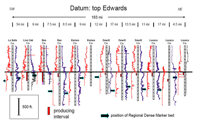
Previous characterizations of the Stuart City shelf margin have focused primarily on general depositional and diagenetic models, including a description of facies based on data from a relatively small number of wells. These studies have led to a “one model fits all” approach to characterize the entire 250+ mile-long (> 400 km) reef margin. The newly acquired PNR data set highlights key differences in depositional settings and reservoir quality of the trend along strike. Preliminary results indicate multiple geologic models are required to accurately characterize this complex and heterogeneous reef/bank margin system. Geologic heterogeneity along strike appears to be fundamentally controlled by deep structure related to basement configuration and faulting and salt-related tectonics. Important secondary controls include the physiographic forms of the Edwards and underlying Sligo shelf margins and the nature and timing of subsidence of the Edwards margin related to development of isolated fault blocks along various portions of the margin. In addition, recognition and correlation of the Regional Dense Marker Bed (RDMB), an important middle Albian stratigraphic datum within the massive Edwards shelf margin succession, have been crucial to understanding changes within the Stuart City margin along strike and in the development of area-specific geologic models.


uAbstract

uFigures

uEdwards trend

uGeologic setting

uPrevious work

uPNR work

uData set

u2004 concept

uData acquisition

uCurrent ideas

uSub-region features

uNew insights

uClosing remarks

uAcknowledgments

uReferences


uAbstract

uFigures

uEdwards trend

uGeologic setting

uPrevious work

uPNR work

uData set

u2004 concept

uData acquisition

uCurrent ideas

uSub-region features

uNew insights

uClosing remarks

uAcknowledgments

uReferences


uAbstract

uFigures

uEdwards trend

uGeologic setting

uPrevious work

uPNR work

uData set

u2004 concept

uData acquisition

uCurrent ideas

uSub-region features

uNew insights

uClosing remarks

uAcknowledgments

uReferences


uAbstract

uFigures

uEdwards trend

uGeologic setting

uPrevious work

uPNR work

uData set

u2004 concept

uData acquisition

uCurrent ideas

uSub-region features

uNew insights

uClosing remarks

uAcknowledgments

uReferences


uAbstract

uFigures

uEdwards trend

uGeologic setting

uPrevious work

uPNR work

uData set

u2004 concept

uData acquisition

uCurrent ideas

uSub-region features

uNew insights

uClosing remarks

uAcknowledgments

uReferences


uAbstract

uFigures

uEdwards trend

uGeologic setting

uPrevious work

uPNR work

uData set

u2004 concept

uData acquisition

uCurrent ideas

uSub-region features

uNew insights

uClosing remarks

uAcknowledgments

uReferences


uAbstract

uFigures

uEdwards trend

uGeologic setting

uPrevious work

uPNR work

uData set

u2004 concept

uData acquisition

uCurrent ideas

uSub-region features

uNew insights

uClosing remarks

uAcknowledgments

uReferences


Selected Figures

Map of the Edwards (Stuart City) shelf margin trend.

Stratigraphic diagram, showing general stratigraphy and position of Stuart City trend.

Mid-late Albian paleogeography (from Kerans, 2002).

Depositional model of Bebout and Loucks (1974).

Depositional model of Scott (1990).

Well-location maps (1985 and 2005) of Pawnee (Edwards reef) field, Bee and Live Oak counties, Texas, with plot of gross production.

Map of Edwards and Sligo shelf edges, showing PNR drilling activity, 2005-2008.

Edwards stratigraphy—two units, based on lithology, petrography, and paleontology and illustrated by core samples and well log, which shows the Regional Dense Marker Bed separating the two units. See Waite et al. (2007).

Cross-sectional diagrams of Edwards A and Edwards B, with modern analog for each.

Regional strike section, Stuart City margin, PNR deep pilot holes. Datum: top Edwards.

Regional strike section, Stuart City margin, PNR deep pilot holes. Datum: base RDMB/top Edwards “B.”


Click to view sections in sequence.

Tectonic/structural map of region of study area, showing elements that partition reef trend into three main provinces, which show varying influence of basement and salt.

Map showing the six sub-regions of the Stuart City (Edwards reef) trend.

Map, well log, and core photo representative of sub-region 1 (LaSalle - McMullen counties--Rio Grande Salt Basin).

Map and well log representative of sub-region 5 (Lavaca County—Word Field complex).

Map of 3D seismic coverage along Stuart City margin.


Edwards (Stuart City) Shelf Margin Trend

  • A narrow belt of Lower Cretaceous reef/bank and associated sediments that extends for > 250 miles across south Texas.
  • Middle Albian Edwards shelf margin underlain by Barremian-Lower Aptian Sligo shelf margin.
  • Dry gas fields in combination traps (discovered in 1960’s); 11,000 - 14,000 ft; up to 350o F; average porosity 5%.
  • Horizontal drilling revitalized play in late 1990’s, aided by today’s higher commodity prices.


Geologic Setting during Early Mid-Cretaceous
(see Markello et al., 2008)

  • Post-Pangea breakup
  • Opening of Tethys seaway
  • Large percentage of continental shelves in low (tropical) latitudes
  • Greenhouse climate
  • Low-amplitude, high-frequency sea-level cycles during long-term rise.
  • Significant global anoxic events in Albian, Turonian.
  • Rise of the rudist bivalves as main reef builders


Previous Work

Bebout and Loucks (1974)

  • First comprehensive description of Stuart City facies
  • Based on analysis of >10,000 ft. of core from 20 wells along trend.
  • Recognized five major environments:
    • shelf lagoon
    • shelf margin
    • upper shelf slope
    • lower shelf slope
    • open marine (basin)
  • Identified 14 separate depositional facies within the 5 environments.
  • Noted cement types, porosity types, and distribution; commented on timing of diagenesis (early cementation).

Shelf margin consists of progradational package of requieniid boundstones and caprinid-algal packstones. Outboard margin is interpreted as “patch reefs” on upper slope. Skeletal grainstones show evidence of brief subaerial exposure.

Scott (1990)
Recognized seven environments (landward to seaward):

  • open lagoon, with mollusk-miliolid-orbitolinid wackestone
  • shoals in lagoon, consisting of grainstone
  • reef flat of rudist-coral packstone
  • reef frame, consisting of coral-stromatoporoid boundstone
  • proximal forereef slope, with coral-rudist packstone
  • distal forereef slope, consisting of bioclast packstone
  • forereef basin, with bioturbated mudstone, oncolite wackestone


Work of Pioneer Natural Resources (PNR)

Data Set

Example: Pawnee (Edwards reef) Field, Bee and Live Oak Counties, Texas

In 1985--   17 wells (no horizontals)
                   4,000 acres (160–320 acre spacing)
                   Producing 8.5 MMCFPD
In 2005--   80 wells (63 horizontals)
                   5,500 acres (80-acre spacing)
                   3-D seismic coverage
                   Producing 50 MMCFPD

PNR’s Incorrect Concept circa 2004

  • Edwards viewed as a continuous trend.
  • Considered more of a “resource” type play.
  • Pawnee was main analog / laboratory: “the whole trend looks just like Pawnee.”

PNR Edwards Trend Data Acquisition (2005 – 2008)

  • 10,000 line-miles of previously acquired 2D seismic
  • Greater than 300,000 acres under lease
  • 85 (and counting) deep pilot holes with full log suites
  • 7 new extensive conventional cores
  • 1000 mi2 of new 3D seismic (full fold across margin)
  • Several new gas discoveries, one significant (Moray Field)
  • Numerous production and engineering data (porosity/permeability, capillary pressure, production rates, decline rates, pressure, etc.)

Current Ideas

  • Two reefs: Edwards ‘B’ vs. Edwards ‘A.’
  • Edwards trend is not a “simple ribbon,” nor is it a true resource play.
  • Structure, facies, and diagenesis are all important.
  • Salt distribution, deep Jurassic / basement faults, and Sligo margin: fundamental control on development of Edwards reef.
  • Very complex system -- “One model” does not fit all.

Features of two examples from six sub-regions

1. LaSalle - McMullen counties (Rio Grande Salt Basin)

  • Center of the Rio Grande Salt basin.
  • Edwards relatively shallow (10 – 12, 000 ft).
  • Sligo margin is far outboard of Edwards margin.
  • Pay section restricted to upper portion of Edwards ‘A’ ( +/- 100 ft of total gas column).
  • Small bioherms with grainstone/packstone cycles.
  • High porosity and permeability (interparticle, vuggy).
  • Best wells on salt-related structural highs; depletion concerns in existing fields.

5. Lavaca County (Word Field complex)

  • Edwards relatively deep (13,500 – 14,100 ft).
  • Edwards margin outboard of Sligo margin.
  • Thick Edwards ‘A’ landward of main shelf edge fault.
  • Island/tidal flat cycles (Word) and associated low-energy, open marine muddy carbonates; highest porosity-permeability in microporous mudstones.
  • Thick gas columns in Edwards ‘A’ (maximum at Word)
  • Outboard, massive Edwards ‘B’ reef is mostly wet.

Summary of New Insights

  • Shelf margin reef is subdivided vertically into two portions:
    • Lower Edwards (‘B’): high relief, barrier-type reef margin
    • Upper Edwards (‘A’): low relief bioherms
  • Geology of Edwards shelf margin controlled in part by basement configuration and salt distribution:
    • Rio Grande Salt Basin / Maverick Basin
    • San Marcos Arch
    • Houston / East Texas Salt Basin
  • More than one geologic model is required to fully characterize the complexities of the reef margin along strike.

Closing Remarks

  • Deep Edwards gas play is challenging.
  • Conventional play with resource play elements.
  • Significant new gas discovery in NW Dewitt County.
  • Moving forward: 3D seismic, control costs.
  • One eye on the microscope; the other on commodity prices.

Acknowledgments

  • Dr. Robert W. Scott, Precision Stratigraphy and University of Tulsa, Tulsa, OK
  • Mr. Walter Bloxsom, Consultant, Houston, TX
  • Dr. Charles Kerans, University of Texas at Austin, Austin, TX
  • Management of Pioneer Natural Resources, Irving, Texas, and and fellow co-workers, South Texas Asset Team

References

Bebout, D.G. and R.G. Loucks, 1974, Stuart City trend, Lower Cretaceous, south Texas: University of Texas at Austin, Bureau of Economic Geology, Report of Investigations 78.

Dravis, J.J., 1991, Carbonate petrography – update on new techniques and applications: Journal Sedimentary Research, v. 61, p. 626-628.

Kauffman, E.G., and N.F. Sohl, 1974, Structure and evolution of Antillean Cretaceous rudist frameworks: Verhandl. Naturf. Ges. Basel, v. 84, no. 1, p. 399-467.

Kerans, Charles, 2002, Styles of rudist buildup development along the northern margin of the Maverick Basin, Pecos River Canyon, southwest Texas: GCAGC Transactions, v. 52, p. 501-516.

Markello, J.R., R.B. Koepnick, L.E. Waite, and J.F. Collins, 2008, The carbonate analogs through time (CATT) hypothesis and the global atlas of carbonate fields – a systematic and predictive look at Phanerozoic carbonate systems: SEPM Special Publication 89, p. 15-45.

Scott, R.W., 1990, Models and stratigraphy of mid-Cretaceous reef communities, Gulf of Mexico: SEPM Concepts in Sedimentology and Paleontology, v. 2, p. 1-102.

Waite, L.E., R.W. Scott, and C. Kerans, 2007, Middle Albian age of the Regional Dense Marker bed of the Edwards Group, Pawnee Field, south-central Texas: GCAGS Transactions, v. 57, p. 759-774.


Return to top.


Copyright © AAPG. Serial rights given by author. For all other rights contact author directly.