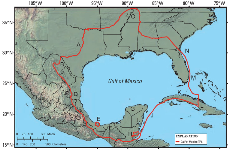
Figure 2. Upper Jurassic-Cretaceous-Tertiary Composite total petroleum system (TPS) for the Gulf of Mexico basin. The letters (A-O) refer to the following notes on how the TPS boundary was drawn. A, coincides with the Upper-Lower Cretaceous outcrop boundary (Schruben et al., 1994); this line may be somewhat arbitrary as the area may include some Interior Platform Paleozoic-derived oil that has migrated into Cretaceous reservoirs and is not part of the Gulf of Mexico TPS; B, includes both Maverick and Sabinas basins, which have Gulf of Mexico basin source and reservoir rock (Eguiluz de Antuñano, 2001; Scott, 2003); C, excludes Sierra Madre Oriental, which has stratigraphic equivalents to Gulf of Mexico basin source and reservoir rocks, but probably has experienced too much structural deformation and erosion to retain any significant hydrocarbon volumes (Ewing, 1991); D, includes the Magiscatzin basin, which has production from units of the main Tampico-Misantla basin, and contains similar strata and structural styles as found in the Gulf of Mexico basin (Nehring, 1991; USGS World Energy Assessment Team, 2000); E, excludes Tuxla Uplift, an Upper Cenozoic volcanic area (Ewing, 1991); F, includes the Pimienta-Tamabra TPS (USGS World Energy Assessment Team, 2000); G, includes north Yucatan, because hydrocarbons are present in Chicxulub Crater cores (Rosenfeld, 2003); H, excludes the Maya Mountains, a metamorphic orogenic complex (Ewing, 1991; Ewing and Lopez, 1991); I, includes the south Yucatan because of the occurrence of isolated oil and gas production and shows (Rosenfeld, 2003); J, line drawn along major sea-floor crustal structural boundary between oceanic crust in the Yucatan basin and back-arc Cuban basins and oceanic crust in the Greater Antilles Deformed Belt (Ewing, 1991; Rodriguez et al., 1995; James, 2004; Schenk et al., 2005); K, includes north Cuba, where there are the same source rocks as in South Florida and the deep-water Gulf of Mexico (Schenk et al., 2000, 2005; French and Schenk, 2004); L, follows an arbitrary limit to the TPS in the Gulf of Mexico basin; M, follows an arbitrary line drawn to separate the Bahamas from the Florida Platform (Ewing, 1991); N, follows the Smackover-Austin-Eagle Ford TPS boundary of Condon and Dyman (2006); O, Mississippi Embayment - includes Tertiary and Cretaceous coal beds as potential sources of biogenic gas, although there is no known hydrocarbon production from this area.