Click to
view posters in PDF format.
Click to
view posters in PDF format.
PSWestern Australia’s Geothermal Resources*
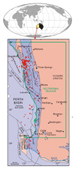
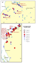
Western Australia commenced a new era in the search of energy from geothermal resources to broaden State’s energy base by the first acreage release for geothermal exploration in the Perth Basin on 22 January 2008 (Figure 1). Coincidently, the first Australian geothermal production well reached its target depth of 4221 m in Geodynamics Habanero 3 (Figure 2). The geothermal acreage release followed the amendments to the State’s Petroleum Act 1967 that was proclaimed in January 2008, Petroleum and Geothermal Resources Act 1967.
South Australia was the first State to develop legislation for geothermal exploration and granted the first Australian Geothermal Exploration Licence (GEL) in 2001. Since then about 12 geothermal wells have been drilled in South Australia by the following companies: Geodynamics, Petratherm, Green Rock Energy, Scopenergy, and Geothermal Resources (Figure 2). There is an increasing trend with exponential increase in interest, companies, and investment for exploring and developing geothermal energy. The investment totalling $686 million has been proposed for five-year work program by 27 companies in 166 licences.
The majority of current and forecast investment to explore for, and demonstrate the potential of, geothermal energy in Australia focused on hot rock enhanced geothermal systems (EGS). The most promising Australian basins include: Cooper Basin in the south-west corner of Queensland and South Australia, the Hunter Valley, New South Wale, and the Perth Basin, Western Australia.
For this century, energy outlook indicates that there will be significant energy supply from geothermal, solar, wind, and hydro resources. Of these, geothermal energy from hot rocks shows the greatest potential for long-term, continuous electricity supply and Australia leading way in EGS technology. The trend in EGS technological advances indicate, within decades, the cost for electricity generation from EGS will be competitive with conventional energy generation from coal and natural gas, and lower than any other form of renewable energy (solar, wind, wave, tidal).
|
|
Geothermal energy includes thermal or electrical power produced from the heat contained in the Earth. There are two basic types of energy that can be sourced from Earth’s heat — that from hydrothermal systems (hot geofluids) and from hot rocks (hot dry rocks, HDR). Geothermal energy from hot rocks differs from the conventional hydrothermal energy process that produces power commercially in geologically active areas. Since 1970 research has been undertaken worldwide aimed at commercial utilization of the Earth’s heat from hot rocks, using technology referred to as EGS (enhanced geothermal systems) that is applied to HDR sources so that energy can be extracted. To utilize hot dry rocks, EGS technology is used to pump water down an injection well to hot basement rocks that may be insulated by a thick cover of sedimentary rocks. A connection is established between injection and withdrawal wells by means of hydraulic fracturing to develop a closed water-circulation system for extracting and transferring heat from hot rocks at depth to the surface. The available heat cannot be increased, but the permeability and water content can be enhanced. The extracted hot fluids are used at the surface for generating electricity. For electricity generation, suitable temperatures for hot water and steam range from 120 to 370°C. In contrast, shallower reservoirs of lower temperature (21-149°C) can be used directly in health spas, greenhouses, fish farms and other industries, and in space-heating systems for homes, schools, and offices. Most sedimentary basins have low-temperature geothermal water for these direct uses. Direct use of low-temperature hydrothermal resources (~50°C) in Australia include swimming pool heating at Perth’s Challenge Stadium, Victoria’s spa developments at Mornington Peninsula and Mataranka, New South Wales’s artesian baths at Moore, Lighting Ridge, and Pilliga. For heating and cooling, heat source pump are in use at the Canberra’s Geoscience Australia building, Hobart’s Integrated Energy Management Centre, Antarctic Centre, and the Aquatic Centre as well as at the Perth’s Melville Aquatic Centre. Medium-temperature hydrothermal resources (50-100°C) are in use in many places in the world, including Birdsville in Queensland. These hydrothermal resources are in use for both direct heating and cooling and electricity production, with a potential to increase the direct use of geothermal energy significantly in Australia. Conversion of geothermal energy into power is economically feasible only when three factors can be satisfied: 1) the resource is located at shallow depths, usually less than 3 km, but possibly as deep as 7 km; 2) porosity and fracture permeability are sufficient to produce large quantities of thermal water, either naturally or by enhanced geothermal system technologies; and 3) the hot geothermal fluids can be efficiently transported (typically less than a few tens of kilometres) to a power-generating facility. Geological, hydrogeological, electrical, magnetic, geochemical, and seismic data are used to locate potential geothermal resources for exploratory drilling. Exploration for geothermal energy has some similarities to petroleum exploration, but with certain key differences (Narayan et al., 1998a), such as high-temperature logging and reservoir stimulation.
Australia is tectonically stable and does not have geologically active areas characterized by volcanism, crustal rifting, and recent mountain building that typically host high-temperature hydrothermal provinces. However, there is potential for geothermal energy from known high heat-producing granites, usually referred to as hot dry rock (HDR) or hot fractured rocks (HFR) sources. Australia is at the forefront of testing the commercial viability of extracting heat energy by EGS — at the Habanero project in the Cooper Basin, South Australia. The objective of the Habanero project is to develop Australia’s first commercial-scale power plant from geothermal resources in stages. A 50 MW power plant is planned for development by mid 2011, which could gradually be expanded to 100s of MW for commercial base-load power plants. The completion of Habanero 3 at target depth of 4221 m is a significant milestone toward commercialization of the HFR geothermal well (Figure 2). At present, the only geothermal energy being used for electricity generation in Australia is from a 120 kW geothermal energy plant located in Birdsville, Queensland. In the last few years, investment into exploration for geothermal energy sources and into technologies for producing geothermal energy from hot rocks and young (about 4000-5000 years old) hot hydrothermal water has increased dramatically, partially stimulated by a Commonwealth Government subsidy scheme. Australia’s most significant geothermal resources suitable for electricity generation appear to be from hot rocks, with the highest potential in the Cooper Basin followed by the McArthur, Otway, Carnarvon, Murray, Perth, Canning, East Queensland, and Sydney basins (Somerville et al., 1994).
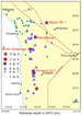
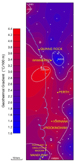
Australian and Western Australian geothermal resources have been discussed by: Sass (1964), Sass et al. (1976), Cull (1977, 1979, and 1982), Cull and Denham (1978), Narayan et al. (1998b), Chopra (2005), Chopra and Holgate (2007), and Ghori (2007 and 2008). First study, specifically to evaluate geothermal energy, for Western Australia, was initiated in the 1980s from hydrothermal resources and recognised low temperature reservoirs (65-85oC) at greater depths (2-3.5 km), with the best economic potential in the Perth Basin (Bestow, 1982). The high temperature hydrothermal resources that are attractive geothermal energy targets in geologically active areas are not found in currently tectonically stable Western Australia, thus further evaluation of geothermal resources were not pursued till 2006. The second study in 2006 targeted hot rock resources that are currently economic, where the depth to 200oC is less than five km. Petroleum wells in parts of the Canning, Carnarvon, and Perth basins indicate two favourable factors for developing Enhanced Geothermal System (EGS), potentially high-heat generating granitic basements, and maximum horizontal stress orientations that are favourable for developing horizontally oriented high temperature geothermal reservoirs. The Carnarvon Basin has the greatest number of wells with high temperature gradients, followed by the Perth and Canning basins (Chopra and Holgate, 2007; Ghori, 2007, 2008). The first study by Bestow (1982), mainly focused on low-temperature geothermal reservoirs up to 100oC, applying the available data on heat flow, geothermal gradient, and hydrogeology to the geological framework of the Yilgarn Craton, and the Eucla, Officer, Canning, Carnarvon, and Perth basins. The study was more qualitative than quantitative and concluded that geothermal and hydrogeological conditions for developing a geothermal resource for both direct use and power generation are present in Western Australia. The second study by Chopra and Holgate (2007) was on high-temperature geothermal reservoirs up to 200oC. The aim of the study was to map and identify the most suitable areas within the Canning, Carnarvon, and Perth basins that may have potential for development of geothermal energy from hot rocks. Further, this study developed a reliable dataset of subsurface temperatures, basement depths, and rock types, and in situ stress conditions for future studies. The Chopra and Holgate (2007) study has evaluated the quality and quantity of available subsurface temperature data from 273 petroleum exploration wells in the Canning (100), Carnarvon (90), and Perth basins (83), and extracted temperature data from more than 580 wells yet to be evaluated. The purpose was to calculate reliable true formation temperatures, to estimate the equilibrium geothermal gradient for each well. Higher than normal geothermal gradients recorded in many wells provided the first indication of high heat flow (Figure 3). In Australian basins, the high crustal temperatures are usually associated with local high-heat production under rocks of low thermal conductivity. At present, detailed geochemical information on the basement in the studied wells is not available. The estimates of equilibrium geothermal gradient and depth to basement have been used to predict the temperature at the top of the basement and the depth at each well location required to reach the 200oC isotherm (Figures 4 and 5). As well, the study evaluated the quality and quantity of stress data available from engineering measurements (e.g., hydraulic fracture and over-coring), earthquake focal mechanisms, borehole breakout, drilling-induced tensile fractures (DITF), and recent geological indicators (e.g., fault slip). These data are available from the Australian Stress Map, which is the most recent compilation of Australian stress data and is a major source of regional stress data for the current World Stress Map (Hillis and Reynolds, 2000; Reinecker et al., 2005). The most prospective basin for geothermal energy appears to be the Carnarvon Basin, followed by the Canning and Perth basins. This is based on the present-day geothermal gradient for wells where the estimated depth to 200°C is less than 5 km (Figures 4 and 5). Geochemical analyses of basement rocks are required to assess the heat-generation capacity of rocks, as small differences in the concentrations of thorium and uranium can have quite significant impacts on heat-generation capacity, whereas large variations in potassium concentration have only a second order effect on the heat-generation capacity. The stress conditions are best known for the Perth Basin where the predominant orientation of the maximum horizontal stress is east-west, with similar conditions inferred for the Canning and Carnarvon basins. Given that this stress orientation is compatible with both strike-slip and overthrust failure, an understanding of relative stress magnitudes is also required for assessing the uncertainty in the application of EGS technology. The extent and economic feasibility of hydrothermal and hot rock geothermal resources are presently unknown because studies were qualitative, rather than quantitative, and based on limited datasets. Data gathering, validating, and interpretation of greater than 900 wells is underway for a quantitative assessment that requires systematic geological, hydrogeological, geophysical, and geochemical evaluation to further delineate and prove these resources.
This north-south elongated trough in the southwest of Western Australia (Figure 1) contains mostly a Permian to Lower Cretaceous succession under a thin cover of Tertiary. The eastern boundary is the Darling Fault and the basin extends offshore to the continental-oceanic boundary. The Perth Basin has been studied since the early 1900s for geological mapping and evaluation of coal, water, mineral, and petroleum resources. The published and unpublished data of these studies are archived in the GSWA Library; they provide detail background on geology of the Perth Basin. This evaluation, as a first look, is mainly based on GSWA publications including those on geothermal resources — Bestow (1982), Chopra and Holgate (2007), Ghori (2007 and 2008); for hydrogeology — Thorpe and Davidson (1991), Davidson (1995), those on petroleum geology — Crostella (1995), Mory and Iasky (1996), Crostella and Backhouse (2000), Owad-Jones and Ellis (2000) and unpublished company reports submitted to GSWA. Most of the data archived in GSWA Library were the basis of the studies consulted for this study. Figure 6 shows generalised stratigraphy of the Perth Basin and distribution of water aquifers, petroleum reservoirs, and potential geothermal resources. Bestow (1982) discussed the hydrothermal resources, and Davidson (1995) provides hydrogeology and groundwater resources of the Perth region. The groundwater resources of the Perth region has been systematically investigated by drilling since 1961, and Neogene to Jurassic aquifers up to a depth of 1100 m are exploited to supplement the industrial and domestic water supply. Six distinct aquifers recognised are: the Quaternary-Neogene Superficial and Rockingham, Paleogene Kings Park, Cretaceous Mirrabooka and Leederville, and Jurassic Yarragadee aquifers (Davidson 1995). The salinity of the groundwater in the youngest Quaternary-Neogene aquifers ranges from about 130 to 12,000 mg/L TDS (total dissolve solids), temperature at the water table ranges from 19 to 24oC, averaging about 21oC (Davidson 1995), and the age of water ranges from present to about 2000 years at the base (Thorpe and Davidson, 1991). Within the Cretaceous Leederville aquifer, the salinity ranges from 176 to 2511 mg/L TDS, and temperature from 20 to 39oC. The average geothermal gradient is about 25oC/km. The oldest Yarragadee aquifer is a major confined aquifer underlying the entire Perth region and extending to the north and south within the Perth Basin. It is a multi-layer aquifer, more than 2 km thick. The salinity of groundwater ranges from 140 to more than 10,000 mg/L TDS, and temperature ranges from 28 to 45oC and averages about 39oC. The geothermal gradient is about 25oC/km. The maximum depth to the base of the aquifer is about 3 km; this indicates temperature of 90oC (using 20oC at the water table). This is comparable to the finding of Bestow (1982): low temperature reservoir ranging from 65oC to 85oC at a depth range of 2 to 3.5 km. The highest temperature groundwater lies beneath the Kings Park Formation in the central Perth region (Davidson, 1995). Figure 7 shows the distribution of: geothermal gradients, and Figure 8 shows the temperature versus depth. These figures are based on data available from 145 artesian monitoring bores. Of these, 47 were used to analyse the subsurface temperatures in which temperature logs were recorded. For each of these wells, temperatures at different depths were compiled and geothermal gradients were computed. The recorded gradients are ranging from the lowest 1.1oC to the highest 4.4oC, to a depth less than one km. These plots indicate the recorded highest as well as the lowest subsurface temperatures are around the Wanneroo area. The lower temperatures are extending towards the north and the higher towards the south of the Wanneroo area. These temperatures indicate low temperature resources up to 50oC at a depth less than one km in areas of high geothermal gradients. Regenauer-Lieb and Horowitz (2007) discussed and encourages the direct use of low hydrothermal resources of the Perth Basin. Petroleum wells (242) provide temperature distribution for a larger area and a greater depth (850 m) than the Perth region water bores. Of these, 83 wells have been studied by Chopra and Holgate (2007) for geothermal gradients and the remaining are under study. Figure 9 shows the Perth Basin subsurface temperatures as a function of depth: a) recorded BHTs (540) in 242 petroleum wells; b) Jurien 1; c) Woodada Gas Field. These plots show that the recorded temperatures and depths are up to 150oC and 4.5 km, respectively. The corrected estimated equilibrium temperatures are expected to be higher than these recorded temperatures, which are generally 10 to 20% higher. For the Perth Basin, the estimated geothermal gradients in 83 wells by Chopra and Holgate (2007) indicate the presence of wells with very high to normal gradients, ranging from 90oC/km to 20oC/km (Figure 3). Gradients in wells deeper than 2 km are considered more reliable and representative for hot dry rock resources. Conceptual models for petroleum and geothermal resources have been developed for the Beagle Ridge (Figure 10a) and the Cadda Terrace (Figure 10b) of the Perth Basin, because high geothermal gradients are observed in Jurien 1 (55oC/km) on the Beagle Ridge and Woodada 02 (40oC/km) within the Cadda Terrace. Jurien 1 was drilled to a total depth of 1026 m and intersected granitic basement at 967 m. The extrapolated recorded temperatures indicate that 200oC is expected to reach between 2.5 km and 3 km (Figure 9b). It is an economical depth for developing geothermal resources, if other factors for developing EGS are found favourable. Figure 9c shows the subsurface temperatures as a function of depth in 17 wells of the Woodada Gas Field. The extrapolated temperatures indicate that 200oC is expected to reach between 4 and 5 km; these are suitable depths for developing geothermal resources with EGS favourable conditions. The reservoir temperature of the Woodada Gas Field is 120oC at depth range from 2125 m to 2496 m (Owad-Jones and Ellis, 2000). For the Perth region as a whole, stress data collected in situ are available from 43 locations at different depths and from different sources, but for the Perth Basin portion, the data are exclusively from borehole breakouts recorded in 20 petroleum exploration wells. The recorded maximum horizontal stress orientations are E-W across the Perth region (Reynolds and Hillis, 2000); these observations are highly relevant for assessing the HDR prospectivity of the basin, because maximum horizontal stress is favourable (Chopra and Holgate, 2007). First acreage release in Western Australia is the beginning of a major expansion in exploration for hot dry rock geothermal resources. Amendments to the Petroleum Act 1967 to grant rights for geothermal energy exploration and development have facilitated the growth of a new industry in Western Australia. Pre-competitive geoscience information relevant to hot rock geothermal exploration largely comes from petroleum exploration wells. These are generally in clusters, sparsely distributed at basin scale. Whereas temperature measurements from petroleum well logs are reasonably reliable, in-situ stress measurements, required for applicable EGS technology are uncertain. Much more reliable geoscience information is required to assist private sector exploration for geothermal resources in Western Australia, most of which will be focused near energy-demand centres or near existing major power-transmission routes (Ghori, 2008).
Bestow, T.T, 1982, The potential for geothermal energy development in Western Australia: Geological Survey of Western Australia, Record 1982/6, 67p.
Chopra, P.N, 2005, Status of the geothermal industry in Australia, 2000-2005: Proceedings, World Geothermal Congress 2005, Antalya, Turkey, 24-29 April 2005.
Chopra, P.N, and F. Holgate, 2005, A GIS analysis of temperature in the Australian crust: Proceedings, World Geothermal Congress 2005, Antalya, Turkey, 24-29 April 2005.
Chopra, P.N, and F. Holgate, 2007, Geothermal energy potential in selected areas of Western Australia; a consultancy report by Earthinsite.com Pty Ltd for Geological Survey of Western Australia: Geological Survey of Western Australia, Statutory petroleum exploration report, G31888 A1 (unpublished).
Cull, J.P, 1977, Geothermal energy prospects in Australia: Search, v. 8, no. 4, p. 117-121.
Cull, J.P, 1979, Regional variations in Australian heat flow: Australia BMR, Journal of Australian Geology and Geophysics, v. 4, no. 1, p. 1-13.
Cull, J.P, 1982, An appraisal of Australian heat flow data: Australia BMR, Journal of Australian Geology and Geophysics, v. 7, p. 11-21.
Cull, J. P, and D. Denham, 1978, A case for research and development on geothermal energy in Australia: Australia Bureau of Mineral Resources, Record 1978/58, p. 7.
Crostella, A., 1995, An evaluation of the hydrocarbon potential of the onshore Perth Basin: Western Australian Geological Survey, Report 43, 67 p.
Crostella, A., and J. Backhouse, Geology and petroleum exploration of the central and southern Perth Basin, Western Australia: Western Australian Geological Survey, Report 57, 85 p.
Davidson, W.A., 1995, Hydrogeology and groundwater resources of the Perth Region, Western Australia: Western Australia Geological Survey, Bulletin 142, 257p.
Ghori, K.A.R., 2007, Search for energy from geothermal resources in Western Australia: September 2007 Petroleum in Western Australia, Western Australia’s Digest of Petroleum Exploration, Development and Production, Department of Industry and Resources, Perth, p. 36-39.
Ghori, K.A.R, 2008, The search for Western Australia’s geothermal resources: Geological Survey of Western Australia Annual Review 2006-07, p. 25-31.
Hillis, R. R., and S. D. Reynolds, 2000, The Australian Stress Map: Journal of the Geological Society, London, v. 157, p. 915-921.
Mory, A.J., and R.P. Iasky, 1996, Stratigraphy and structure of the onshore northern Perth Basin, Western Australian Geological Survey, Report 436, 102 p.
Narayan, S.P., D. Naseby, Z. Yang, and S.S. Rahman, 1998a, Petroleum and hot dry rock: two of the energy sharing commonalities: APPEA Journal 1998, p. 830-847.
Narayan, S.P., D. Naseby, Z. Yang, and S.S. Rahman, 1998b, Creation of HDR reservoirs under Australian in-situ stress conditions, in Proceedings of Twenty-third Workshop on Geothermal Reservoir Engineering: Stanford University, Stanford, California, USA, January 1998, p. 322-329.
Owad-Jones, D., and G. Ellis, 2000, Western Australia atlas of petroleum fields, Onshore Perth Basin: Petroleum Division, Department of Mineral and Energy Western Australia, Volume 1, 114 p.
Regenauer-Lieb, K., and F. Horowitz, 2007, The Perth Basin geothermal opportunity: September 2007 Petroleum in Western Australia, Western Australia’s Digest of Petroleum Exploration, Development and Production, Department of Industry and Resources, Perth, p. 42-44.
Reinecker, J., O. Heidbach, M. Tingay, B. Sperner, and B. Müller, 2005, The release of the 2005 World Stress Map: World Stress Map Project, Geophysical Institute, Karlsruhe University (http://www.world-stress-map.org).
Sass, J.H, 1964, Heat-flow values from the Precambrian of Western Australia: Journal of Geophysical Research, v. 69, no. 2, p. 299-308.
Sass, J.H., J.C. Jaeger, and R.J. Munroe, 1976, Heat flow and near-surface radioactivity in the Australian continental crust: United States Geological Survey, Open-File Report 76-250, 91p.
Somerville, M., D. Wyborn, P. Chopra, S. Rahman, D. Estrella, and V.D.M. Theo, 1994, Hot dry rock feasibility study, a report compiled for the Energy Research and Development Corporation: Canberra, Australia, Energy Research and Development Corporation, ERDC 94/243, 133p.
Thorpe, P.M., and W.A. Davidson, 1991, Groundwater age and hydrodynamics of the confined aquifers, Perth, Western Australia, in Proceedings of the International Conference on Groundwater in Large Sedimentary Basins, Perth, Western Australia, 1990: Australian Water Resources Council Series, no. 20, p. 420-436. |