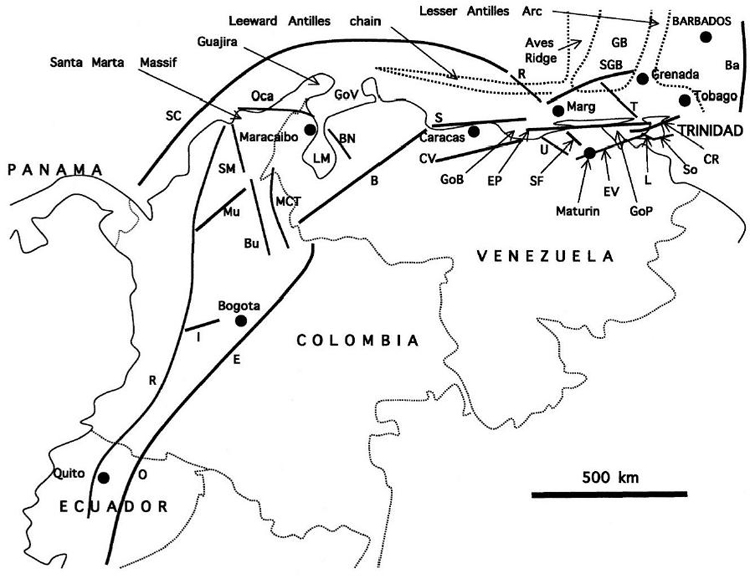
Figure 1. Location map and major faults of northwestern South America. Basins: GB=Grenada, GoB=Gulf of Barcelona, GoP=Gulf of Paria, GoV=Gulf of Venezuela, LM=Lake Maracaibo, SGB=South Grenada Basin. Faults: B=Bocono, Ba=Barbados accretionary prism frontal thrust, BN=Burro Negro, Bu=Bucaramanga, CR=Central Range, CV=central Venezuela frontal thrust, E=East Andean frontal thrust, EP=El Pilar, EV=eastern Venezuela frontal thrust, I=Ibague, L=Los Bajos, MCT=Mercedes-Caño Tomas, Mu=Murrucucu, O=Oriente, R=Romeral, R=Roques Canyon, S=San Sebastian, SC=South Caribbean, SF=San Francisco, So=Southern sole thrust, SM=Santa Marta, T=Testigos, U=Urica. Marg=Margarita island. Dotted outline of Aves Ridge, Leeward Antilles extinct arc, and Lesser Antilles Arc is the approximate 1500 m isobath. Tobago and Barbados mark the leading (eastern) edge of Caribbean crystalline crust. Main sources: Kugler, 1961; Parnaud et al., 1995; Villamil, 1999; F.A. Audemard et al., 2000; Paris et al., 2000; Escalona and Mann, 2006.