 Click to view posters in PDF format.
PSSubsurface Characterization of a Carbon Sequestration Pilot Site: San Juan Basin, New Mexico*
By
Brian Henthorn1, Tom Wilson1, and Art Wells2
Search and Discovery Article #80005 (2007)
Posted June 25, 2007
*Adapted from poster presentation at AAPG Annual Convention, Long Beach, California, April 1-4, 2007
1West Virginia University, Morgantown, WV ([email protected])
2National Energy Technology Laboratory, Pittsburgh, PA
Successful sequestration of CO2 requires that the majority of injected CO2 remain underground for hundreds to thousands of years. Evaluation of site integrity is important in the design and implementation stages of the sequestration effort. This study presents some of the background evaluation undertaken of a Fruitland coal pilot sequestration site located in the San Juan Basin. The study includes comparison of fracture trace data measured in the field and in high resolution QuickBird satellite imagery. Prominent fracture systems are exposed along the edges of mesas formed in the nearly flat-lying Eocene age San Jose Formation. Fracture trend varies considerably, however, rose diagrams reveal two prominent fracture sets: one trending ~N30E and the other ~N45W. Analysis of the QuickBird image reveals similar variability along with two prominent sets: one trending N35E and another smaller set trending N50W. Previous studies in the area suggest that the face cleat orientation and direction of preferential flow during CO2 injection will follow the NE trend. The site lies in the "High Rate Fairway" near a structural low in the Fruitland Formation. Subsurface maps help determine whether smaller scale folds and faults similar to those observed to the northwest in the Cedar Hill area exist. If present, they may exert additional control on CO2 flow patterns and serve as potential avenues for CO2 escape. The study will help National Energy Technology Laboratory scientists position tracer and soil monitors at the site.
|
|
Figures 1-1 - 1-5
Bedrock geology of the area consists primarily of nearly flat lying tan conglomeritic sandstone and shale of the Cuba Mesa Member of the basal Eocene age San Jose Formation (approximately 54 My). An exposure typical of the area is shown in Figure 1-1. Exposures are dominated by a series of sands and shales. The mesa is underlain by a thick sandstone (Upper sand in Figure 1-1), followed by a thin shale, a more massive sand (the Middle sand), a thick shale sequence and a basal sand (not shown). Evidence of active drainage during wetter periods as well as seep and spring activity is notable along the flanks of the mesas in this area.
Satellite Observations of Surface Fracture Systems As part of our site characterization activities we acquired high resolution QuickBird imagery over the site to give us close-up views of surface rock exposure as well as up-todate views of roads, well pads and streams in the area. The QuickBird image provides 0.6 meter ground cell resolution. The resolution was good enough that larger more extensive fractures could be mapped in the area (Figure 1-2). This gave us the opportunity to compare fracture systems measured in the field with those mapped in the QuickBird image (Figure 1-3). Local fracture trends observed in the field and imagery varied with position on the mesa. Overall, the field measured fractures at the initial field site are characterized by two dominant fracture trends: one, ~N35E and another, ~N50W. In the QuickBird image, the fracture trends were dominated by a N35-40E trending set, and a smaller number of ~N50W trending fractures. The study also incorporated analysis of lineaments on a satellite radar image of the area which revealed N50W and N40E-trending sets, and on Landsat imagery, which revealed N50W and N50E trending sets. The results of this local study revealed consistency of results between image derived fracture and lineament trends with fracture trends measured in the field.
Revised Location of the Pilot Site The CO2 injection well was relocated this past year, and continued activities have been focused on evaluating the new site (red dot up on the mesa in the 3D perspective view (Figure 1-4). The injection well is located on top of the mesa which lies about 70 meters above canyon floors to the south and southwest. The canyon heads appear to develop primarily through groundwater sapping. The massive sands that form the resistant mesa floor and prominent benches along the canyon wall are underlain by seeps in places. Rock falls often point up-slope to these seeps. The rose diagrams of QuickBird fracture traces measured in the West Canyon reveals prominent N50E and N35W-trending sets (Figure 1-5. left). Fracture trends in the Southeast Canyon are dominated by the N50E set (Figure 1-5, right). The trends in this area are rotated about 10o east of those observed a kilometer southwest near the previous site shown at the top of this panel.
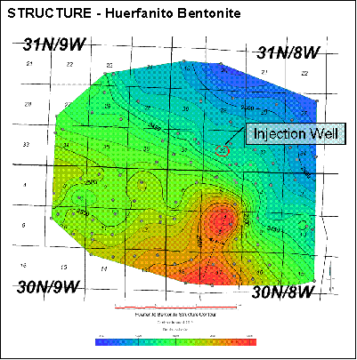
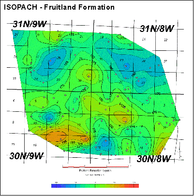
During Late Cretaceous, the San Juan Basin was situated on the western edge of the Western Interior Seaway (see Late Cretaceous paleogeography of the area [Figure 2-1]). The Fruitland and its associated sediments were deposited at the end of the final regression of this seaway across the basin area, resulting in a vertical succession of marine through continental deposits. The Fruitland Formation sediments represent continental deposits, including mudstone, siltstone, sandstone, carbonaceous shale, and coals deposited in coastal swamp environments just landward of the underlying shoreface sands of the Pictured Cliffs Sandstone (Ayers, et al. 1994; Fassett, 2000). The Pictured Cliffs acted as a substrate for deposition of the Fruitland Formation peats, and as a result the Fruitland overlies and interfingers with the Pictured Cliffs. Fruitland deposition and accumulation was dependent upon the regressing Pictured Cliffs shoreface at that time. This coupled with the fact that its upper contact with the overlying Fruitland Formation is usually a distinct contact, easy to pick out on well logs, made the Pictured Cliffs Sandstone an important geologic surface to map for this study. At the very end of the Cretaceous and into Early Tertiary the Western Interior Foreland Basin was broken up into discrete sub-basins by means of Laramide associated uplifts (Dickinson et al., 1988). The present-day structural configuration of the San Juan Basin (Figure 2-2) is bounded by these uplifts. One of the objectives of the structural mapping is to identify faults that might crosscut the lower or basal Fruitland coal (the target injection zone). NE- and NW-striking fault systems are commonly observed in seismic throughout the basin (Taylor and Huffman, 1998). If present , these fault systems could act as conduits and facilitate escape of injected CO2 back to the surface. The cross-sectional geometry (Figure 2-3) of the San Juan Basin is that of an asymmetric syncline, with a depocenter and hinge axis occurring along the northern and northeastern margins of the basin. The structure contour map of the Huerfanito Bentonite (Figure 2-4) reveals local structural complexity in the basin. Dip in the area is generally to the northeast. The tentative location of the pilot site (center of section 32, township 31N/8W) lies southwest of the axial hinge of the basin. The regional structural characteristics of the area are interrupted by the north-plunging nose of an anticline in the southern part of the map area. The Huerfanito is interpreted to be associated with a large ash fall and therefore represents an isochronous marker bed throughout the region (Fassett, 2000). The structural high to the south and southwest shows up to varying degree in shallower structure maps. Structure contours on the top of the Fruitland Formation (Figure 2-5) and the Pictured Cliffs Sandstone (Figure 2-6) reveal greater structural complexity that could in part be linked to depositional features in associated distributary-channel and delta-plain environments or with syndepositional tectonic influences. The high to the southeast persists across the top of the Fruitland and plunges to the north-northeast. In the southeast quadrant of the map shown here, the structural relief on the Pictured Cliffs is approximately 100 feet in areas of relatively tight well control. Slightly less relief (~90 feet) is observed on the top of the Fruitland. The Fruitland Formation isopach (Figure 2-7) reveals that structurally high areas in the Pictured Cliffs and Fruitland are generally associated with thickening of the Fruitland by 15 to 20 feet or so. Net coal maps were constructed through interpretation of bulk density logs; a density cutoff of 1.75 gm/cm3 was used to distinguish between less dense coal and carbonaceous shale (see Figure 3-1). Two net coal maps (Figures 2-8 and 2-9) were produced: one consisting of net coals of the entire Fruitland Formation, another consisting of net coals for only the Basal Fruitland Coal - the sequestration target formation. Basal coals correspond to coals in the lower part of the Fruitland Formation with partings of less than 10 ft. The Fruitland Formation net coal map (Figure 2-9) reveals overall thinning of net coal in the southeast portion of the map and thickening of net coal to the north. This correlates with an elongate structural high observable in structure contour maps of both the Pictured Cliffs and the Fruitland. Thickening of net coal appears to occur over structurally low areas of the Pictured Cliffs in the northern part of the map. This relationship is also apparent in the Basal Fruitland net coal map (Figure 2-8). A belt of thickened Fruitland Fm. extends across the southern part of the area and suggests that the structural highs in this area postdate deposition of the Fruitland. Thinner net coal to the south (thinning from ~65 to 35 feet for the net coal and from ~24 to 10 feet for the basal coal) combined with the thicker Fruitland section may result from channeling and scouring of the coals in that area. Characteristic gamma ray and density log responses for intervals presented in this study are presented in Figure 3-1. The top of the Fruitland Formation is generally marked by an upper low density and low gamma ray coal zone. Three mappable coal zones are observed in the area: The basal, middle and upper coals. The Southwest Region Partnership plans to inject CO2 into the basal coal. The basal coal is subdivided into an upper and lower coal zone by a high gamma ray interpreted shale marker that persists through the map area. This marker bed is likely impermeable and may influence CO2 and methane flow through the Basal Coal. The location of the type log is highlighted on Pictured Cliffs top structure map (Figure 2-6).
Surface fracture mapping conducted near the Southwest Region Partnership’s San Juan Basin coal sequestration pilot site reveals two distinct sets of fractures: one trending NW and the other NE. Considerable consistency exists between fracture sets measured in the field and those measured on QuickBird imagery of the area. CO2 leakage, if it were to occur, would likely be controlled by the surface fracture systems and develop along the major NW and NE fracture trends in the area. Tremain et al. (1991) note that the face cleat trend in the Fruitland coals of this area is NE-SW. The dominant NE-SW fracture trend, along with the observation of Tremain et al., suggests that enhanced methane flow is likely along the NE-SW trend in this area. Structural mapping based on geophysical logs from more than 170 wells near the proposed injection site and surrounding area does not reveal the presence of significant local structure within a mile or so of the injection well. Near the site, the Fruitland top and base dip northeast about 20 to 30 feet per mile. The Fruitland Formation thickens by about 10 feet across the pilot site to the southeast. Low relief structures are present in the surrounding area. The most prominent are structural highs south and southeast of the site on the top and base of the Fruitland Formation. There appears to be little possibility that the gently dipping structure in the immediate vicinity of the pilot site could enhance fracturing in the Fruitland and overlying strata. The surface fracture study reveals that natural fracture systems are pervasive throughout the area and influence the development of surface topographic features. Injection pressures exceeding the hydrostatic pressure (around 1400 PSI in this area) could open naturally occurring fracture systems and likely force injected CO2 into overlying strata. Canyons developed in the surrounding area often follow the dominant northeast and northwest trends of the surface fracture systems. We recommend that additional soil gas and tracer sampling of nearby canyon heads and their extensions onto the site mesa be added to the long term monitoring activities planned for the site.
This research was funded through Research and Development Solutions, LLC contract 41817M2100(&111). We wish to thank Dave Wildman (Pittsburgh NETL) for his support of these endeavors. General information about wells in the area (well ID, operator, latitude and longitude) was obtained from Whitestar Corporation. Well and log files were obtained from the New Mexico Oil Conservation Division Energy and Mineral Resources web site at http://ocdimage.emnrd.state.nm.us/. Landmark Graphics Corporation Discovery Suite software were used to generate subsurface maps in this study.
Ayers, W.B., Jr., Ambrose, W.A., and Yeh, J.S., 1994, Coalbed methane in the Fruitland Formation, San Juan Basin—Depositional and structural controls on occurrence and resources, in Ayers, W.B., Jr., and Kaiser, W.R., eds., Coalbed Methane in the Upper Cretaceous Fruitland Formation, San Juan Basin, New Mexico and Colorado: New Mexico Bureau of Mines and Mineral Resources Bulletin 146, p. 13–40. Baumgardner, R., 1991, Lineament analysis of Northern San Juan Basin, New Mexico and Colorado - Applications to coalbed methane exploration: in Schwochow, S., Murray, D., and Fahy, M., eds., Coalbed methane of western North America; Guidebook for the Rocky Mountain Association of Geologists Fall Conference and Field Trip, Rocky Mountain Association of Geologists, Denver, Colorado,. pp. 21-34. Blakey, Ron, Late Cretaceous Paleogeography map posted on http://jan.ucc.nau.edu/~rcb7/crepaleo.html. Dickinson, W.R., Klute, M.A., Hayes, M.J., Janecke, S.U., Lundin, E.R., McKittrick, M.A., and Olivares, M.D., 1988, Paleogeographic and paleotectonic setting of Laramide sedimentary basins in the central Rocky Mountain region: Geological Society of America Bulletin, v. 100, no. 7, p. 1023-1039. Fassett, J.E., 2000, Geology and coal resources of the Upper Cretaceous Fruitland Formation, San Juan Basin, New Mexico and Colorado, Chapter Q, in Kirschbaum, M. A., Roberts, L.N.R., and Biewick, L.R.H., eds., Geologic Assessment of Coal in the Colorado Plateau: Arizona, Colorado, New Mexico, and Utah, compiled by Colorado Plateau Coal Assessment Group: U.S. Geological Survey Professional Paper 1625-B, Version 1.0, p. Q1-Q131. [CD-ROM]. http://greenwood.cr.usgs.gov/energy/coal/PP1625B/Reports/Chapters/Chapter_Q.pdf. Meek, R.H., and Levine, J.R., 2005, Delineation of four “type producing areas” (TPAs) in the Fruitland Coal Bed Gas Field, New Mexico and Colorado, using production history data: AAPG Extended Abstracts (http://searchanddiscovery.net/documents/abstracts/2005annual_calgary/abstracts/meek.htm). Taylor, D., and Huffman, Jr., C., 1998, Map showing inferred and mapped basement faults, San Juan Basin and vicinity, New Mexico and Colorado: USGS Geologic Investigation Series, map with text. Tremain, C.M., Laubach, S., and Whitehead, N., 1991, Coal fracture (cleat) patterns in Upper Cretaceous Fruitland Formation, San Juan Basin, Colorado and New Mexico - Implications for Coalbed methane exploration and development: in Schwochow, S., Murray, D., and Fahy, M., eds., Coalbed methane of western North America; Guidebook for the Rocky Mountain Association of Geologists Fall Conference and Field Trip, Rocky Mountain Association of Geologists, Denver, Colorado, p. 49-59.
|


