 Click
to view article in PDF format.
Click
to view article in PDF format.
Cenozoic Tectono-Stratigraphic Relationships between the Cesar Sub-Basin and the Southeastern Lower Magdalena Valley Basin of Northern Colombia*
By
Alejandro Mora1 and Alberto Garcia1
Search and Discovery Article #30046 (2006)
Posted November 27, 2006
*Adapted from extended abstract prepared for presentation at AAPG Annual Convention, Houston, Texas, April 9-12, 2006
1Drummond Ltd. Bogotá, Colombia ([email protected])
Introduction
The boundary between the Cesar Sub-basin (CS) and the southeastern Lower Magdalena Valley Basin (LMV) of northern Colombia comprises a poorly understood area that has been controlled mainly by the activity of the Santa Marta-Bucaramanga Fault System (SMBF). Several regional studies have been made in both the CS (ICP/Ecopetrol,1990; Intera-Bioss, 1995; Ecopetrol/Geopetrocol, 1998) and in the LMV (Reyes, Montenegro and Gómez, 2000), but none of them has studied the boundary between both basins. Other papers have studied the evolution of the different tectonic blocks of northern Colombia (Hernández, Rámirez and Reyes, 2003), without providing much detail concerning the boundaries between the blocks. The scarce seismic coverage of the area between the CS and the eastern LMV, the poor quality of the seismic data, and the lack of integration of the data from both basins are the main causes of its poor geological knowledge. One of the very few previous attempts to integrate data from both basins was carried out by Baquero, Chamorro, and Aya (1990), but none of this data has been published. Due to the hydrocarbon and coalbed gas exploration activities that have been carried out by Drummond Ltd. (DLTD) in recent years, new data of the boundary between the CS and eastern LMV has been obtained. According to the seismic interpretation and mapping, the kinematic behavior of the SMBF changed dramatically in the Oligocene, and this is the main cause of the contrasting stratigraphic and structural configurations of both basins. A proposal of new models for the tectonic evolution of northern Colombia is beyond the scope of this paper, mainly because there are extensive areas that have very few and poor data. The main objective of this article is to present a new structural model of the area which resulted from the reprocessing, interpretation, and mapping of the available 2D seismic data and from an attempt to integrate the data from the eastern LMV and the CS.
|
|
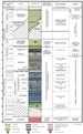
Geological SettingThe Andes Mountains in Colombia are divided into three branches or “Cordilleras” with different tectonic histories and configurations (Figure 1). However, toward the north the topographic expression of the Western and Central Cordilleras ends against the LMV, whereas the Eastern Cordillera splits almost at the same latitude into two branches that form the Santander Massif and the Sierra de Perijá (SP) in the west and the Mérida Andes in the east. These two branches form part of the southern half of the Maracaibo Tectonic Block, a triangular-shaped block that also comprises the Sierra Nevada de Santa Marta (SM), the Cesar-Ranchería Basin (CRB), and the Maracaibo Basin (MB), and it is limited by the SMBF in the west, the Oca-El Pilar Fault System in the north, and the thrust front of the Mérida Andes in the southeast (Figure 1). The CRB has been subdivided into the CS in the south and the Ranchería Subbasin (RS) in the north. Most of the study area is located in the CS since DLTD’s mining and coal and gas exploration operations are focused there (Figure 2). The boundary between the Maracaibo Block and other tectonic blocks in the west, including the LMV, is the SMBF which most authors have interpreted as a single, straight SSE-NNW-trending structure. This article will present the structure and configuration of this boundary and will briefly discuss the possible implications on the tectonic evolution of the area. The stratigraphy of both basins is different mainly due to the action of the SMBF. DLTD has studied in detail the stratigraphy of the main depocenter of the CS in the La Loma Block called La Loma Syncline (Figure 2), in which Cretaceous to Lower Paleogene and some Neogene units have been preserved. The main oil targets in the CS are Cretaceous carbonates and thin sandstones, whereas the coal-bearing unit is the Cuervos Formation of Late Paleocene age (Figure 3). The post-Paleocene deposits have not been studied much; they consist of fluvial, coarse-grained, poorly consolidated deposits. By contrast, in the eastern LMV, the Cretaceous to Paleocene units are absent whereas the post-Paleocene deposits are much thicker and correspond to deposition in more distal fluvial, deltaic, and even deep-marine settings in the main basin depocenters. In this area, the sedimentary infill consists of the deltaic Oligocene-lower Miocene Cienaga de Oro Formation, which is the main oil target, the marine Miocene Porquero Formation, and younger shallow-marine to continental units. This post-Paleocene succession was unconformably deposited on top of the pre-Cretaceous crystalline basement. The Structure of the Boundary between the Eastern Lower Magdalena Valley Basin and the Cesar Sub-Basin The database that was used for this study consists of more than 2300 km of 2D seismic, data from 7 wells in the CS and 7 wells in the eastern LMV (Figure 2), satellite images, Digital Elevation Models (DEMs), and regional geological maps and reports. Additionally, DLTD’s coal exploration database, including more than 1300 shallow wells (less than 2000 ft), was also used. An important aspect was the reprocessing of 567 km of 2D seismic that was done by DLTD; this allowed a much better imaging of the southwest part of the CS, toward the SMBF. High-resolution seismic data was also acquired by DLTD. Figure 4 is a strike seismic line that shows the main reflectors and seismic packages that were identified and mapped in the CS. Two main seismic packages that are separated by angular unconformities were identified. The older seismic package, which includes Cretaceous to Eocene(?) units, is preserved in the CS under an angular unconformity of probable Late Eocene- Early Oligocene age (Figure 4). The younger seismic package includes post-Eocene(?) deposits that are equivalent to the Tertiary sedimentary infill of the LMV, as will be shown later. This means that an intense deformation episode, probably in Late Eocene-Early Oligocene times, folded the CS, uplifted the basement, and caused the removal of the Cretaceous to Eocene (?) units in the southwest part of the CS. The time map shown in Figure 5 (base Cretaceous map) illustrates the structure of the pre-Cretaceous basement in the study area. The general structure of the CS consists of NW-verging, SW-NE-trending thrust faults with strike-slip influence, and a main depocenter, La Loma Syncline. Most of the SW-NE faults curve and change their orientation as they approach the SMBF, resembling a horsetail splay structure that could be suggestive of the northern termination of the Bucaramanga Fault System. The configuration of the eastern LMV consists also of SW-NE-trending structures, but one of the differences from the CS is the normal faults with influence of strike-slip movement. One of these faults has been interpreted as the Palestina Fault, a major right-lateral strike-slip fault of central Colombia (Reyes, Montenegro and Gómez, 2000). Between both basin areas, a boundary or transition zone affected by the activity of the SMBF that displays structures with a completely different orientation (SSE-NNW) can be subdivided into two different structural domains, one in the south and one in the north. The southern domain comprises a basement high that has been an active topographic barrier since Oligocene times (Figures 4 and 5), and the northern domain consists of a basement depression through which both basin areas have been connected also since Oligocene times. This connection is evident in the map (Figure 6) that represents the base of the post-Eocene deposits and in the seismic lines shown in Figures 7 and 8. The map shows how the post-Eocene(?) sedimentation that took place in the core of the La Loma Syncline continued toward the LMV in the west, passing north of the basement high. Additionally, it shows that, while the LMV has been an area with relatively continuous sedimentation since the Oligocene, most of the CS has been a positive element that has undergone erosion and has been a sediment source area. In fact, the seismic lines in Figure 8 display the pre-Oligocene paleo-topography over which the late Oligocene to Quaternary tectono-sequences of the eastern LMV were deposited. The seismic patterns suggest that sedimentation began in a lowstand fluvial to shallow-marine prograding wedge, probably during latest Oligocene times. Considering the slope of the paleo-topographic surface, valley incision probably occurred up-slope toward the NE. Lower Miocene and younger sequences were deposited on top of the initial lowstand wedge, but their detailed description and identification are beyond the scope of this study. Toward the eastern LMV there is a prominent structure that reflects activity during the Neogene. It is a NW-SE-trending graben of transtensional origin, consisting, according to several authors (e.g. Reyes, Montenegro and Gómez, 2000), of two main faults, the Algarrobo-Ariguaní Fault System in the west and the SMBF in the east (Figures 5 and 6). This structure seems to terminate in the south toward the basement high, but unfortunately there is not enough data to study the area in which these two structures converge.
Discussion and ConclusionsConsidering the previous description of the structure of the transition between the CS and the eastern LMV, there are several issues that have to be discussed regarding the SMBF as the boundary between the two basins. In terms of the structure and configuration, the so-called SMBF, between the CS and the eastern LMV, displays noteworthy changes at different stratigraphic levels, indicating that its kinematics have changed during each of its activity episodes. This study documents only the most recent (post-Paleocene) episodes, with the most intense of them taking place in the Late Eocene-Early Oligocene. In that time, the CS was a downthrown block that was folded and eroded toward the area occupied today by the LMV. The intense deformation caused the removal of the Cretaceous to Eocene (?) units. Unfortunately, the low seismic resolution and quality do not allow clear identification and tracing within the pre-Cretaceous basement of the fault system that was responsible for such intense deformation. Therefore, the trace of the SMBF during Late Eocene-Early Oligocene times could roughly coincide with the inferred trace that is shown in the maps (Figures 5 and 6). By contrast, the map of the late Eocene-early Oligocene Unconformity (Figure 6) indicates that the SMBF changed dramatically its kinematic behavior since Oligocene times when the CS underwent compression and uplift finally to become the positive feature that is seen today, while the LMV became an area of relatively continued extension and sedimentation within a transtensional regime. Additionally, the seismic data clearly shows that both basins have been connected in some areas since the Oligocene, and therefore the activity of the SMBF at least within the study area was not as intense as in the previous pulse. All the aforementioned indicates that the SMBF is a mature-stage wrench zone that was responsible for the intense structural deformation that affected pre-Oligocene units; what indicates that it was an active boundary between the CS and the eastern LMV during the late Eocene- early Oligocene. By contrast, since Oligocene times the role of the SMBF as an active fault system that separates both basins lost importance because the two basins have been connected without major tectonic disturbances. However, the Oligocene to Recent behavior of the SMBF as shown in this article allows several interpretations that could explain the local connection between both basins and the not-very-significant displacement of the fault system. One interpretation is to separate the SMBF into two different but related segments, a southern segment, the Bucaramanga Fault, and a northern segment, the Santa Marta Fault, following the suggestion of authors like Ujueta (2003). Other interpretations consider that the oblique strike-slip stresses along the SMBF would allow the formation of a zone with virtually no displacement within the study area (toward the middle of the fault system), whereas in other areas toward the end of the fault system there would be significant displacement. This displacement could be mostly vertical in case of a scissor-type fault or horizontal in case of fault blocks that rotate horizontally. It must be noted that the horizontal rotation of tectonic blocks has been proposed by several authors, such as Reyes, Montenegro and Gómez (2000). Another issue that has to be considered is the role of other major oblique faults, such as the Palestina Fault (Figure 5), that would influence the notable changes in configuration and activity that the SMBF exhibits along its trace. However, the general interpretation of the Tertiary evolution of the SMBF presented in this study, based on the tectono-stratigraphic relationships between the Cesar Sub-basin and the eastern Lower Magdalena Valley, has to be integrated with regional paleotectonic and paleogeographic reconstructions in northern Colombia; it also implies that some of the previous reconstructions have to be re-evaluated.
ReferencesBaquero, E., Chamorro, M. and Aya, D., 1990, Interpretación Estructural Area El Paso, Sub-Cuenca del Cesar: Proyecto No. 15, Ecopetrol Internal Report, Bogotá. Ecopetrol/Geopetrocol Ltda., 1998, Potencial Petrolífero Cuenca Cesar-Ranchería-Informe General: Ecopetrol Internal Report, 5 volumes. Geoconsulta Ltda., 1988, Informe Proyecto Guajira-Cesar-Ranchería: Ecopetrol Internal Report. ICP/Ecopetrol, 1990, Proyecto Cesar-Ranchería, Informe Final: Ecopetrol Internal Report, Piedecuesta, Santander. Hernández, R., Ramírez, V., and Reyes, J., 2003, Evolución Geohistórica de las Cuencas del Norte de Colombia, in VIII Simposio Bolivariano-Exploración Petrolera en las Cuencas Subandinas, Cartagena, Memoirs, Volume 2. Intera/Bioss, 1995, Evaluación Geológica Regional de la Cuenca de Cesar-Ranchería: Ecopetrol Internal Report, Bogotá. Reyes, A., Montenegro, G., and Gómez, P., 2000, VII Simposio Bolivariano-Exploración Petrolera en las Cuencas Subandinas, Caracas, Venezuela, Memoirs, Volume 1. Ujueta, G. 2003, La Falla de Santa Marta-Bucaramanga no es una sola falla; son dos fallas diferentes: La Falla de Santa Marta y la Falla de Bucaramanga: Geología Colombiana No. 28, Universidad Nacional de Colombia, Bogotá. |


