 Click
to view presentation in PDF format.
Click
to view presentation in PDF format.
Elm Coulee Field
Middle Bakken Member (Lower Mississippian/Upper Devonian)
Richland County, Montana*
By
Bill Walker1
Al Powell1, Dick Rollins1, and Ron Shaffer1
Search and Discovery Article #20041 (2006)
Posted November 12, 2006
*Adapted from presentation at AAPG Rocky Mountain Section meeting, Billings, Montana, June 11-13, 2006
1Headington Oil Co., LP, Denver, CO ([email protected])
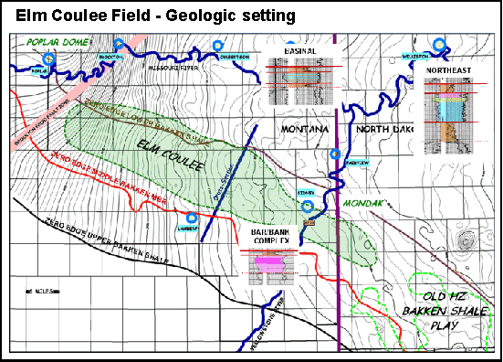
Elm Coulee Field, located in the Richland County, MT portion of the western Williston Basin, has been informally named by the MT Oil & Gas Commission to cover Bakken (Lower Mississippian / Upper Devonian) formation production in the county that is not located under previously designated field areas. Over 350 horizontal development wells have been drilled since the field’s initial horizontal producer was drilled in 2000 by LYCO Energy. Current data indicates estimated ultimate reserves per horizontal well ranging to over 1,500,000 bbls of oil, averaging approximately 500,000 bbls per well. From wells drilled to date, the field is expected to produce in excess of 270 million bbls of oil from an area of over 550 square miles. The field is currently producing over 1.7 million barrels of oil per month (55,000+ bbls/day) and has produced over 33 million barrels of oil since its discovery in 2000. Current and planned exploratory drilling activity may expand the limits of the field dramatically.
One or two wells are currently drilled in each spacing unit in the field, which range in size from 320 to 1960 acres, with most wells drilled on 640 and 1280 acre spacing units. Vertical drilling depths range from less than 8,500 feet in the NW portion of the field to more than 10,500 feet in the SE portion. Up to three horizontal laterals are drilled from each vertical well to a lateral distance of from 1,600 feet to over 10,000 feet. Horizontal drilling and large fracture treatment stimulations are keys to developing economically viable reserves from this field, with prior Bakken production from vertical wells in the area having been generally very disappointing.
The field is primarily a stratigraphic trap developed in the Middle Member of the Bakken formation with a variable and uncertain contribution of production from the overlying, fractured Upper Shale Member of the Bakken. The Middle Bakken Member appears to be the principal reservoir and is primarily a dolomite, variably silty with scattered pyrite and anhydrite, and with increasing argillaceous content toward its base. The Middle Bakken reservoir appears to have developed diagenetically within a large, and complex carbonate bar/bank accumulation which extends over 130 miles from NW to SE, ranging from 6 to 15 miles in width and up to 35 feet thick (thinner and narrower to SE). This complex, variably productive throughout its length, stretches from northwestern Richland County, MT, to southwestern Dunn County, ND, parallel to and basinward of the southwestern margin/shoreline of the Middle Bakken depositional basin. Structurally, in its length of 60+ miles across Richland County, the Bakken pay zone dips about 2,000 feet from NW to SE, traversing over a few small, local structural closures that often produce from deeper Devonian, Silurian and Ordovician reservoirs.
Within the highly productive Richland County portion of the bar/bank complex, the reservoir is slightly overpressured (approx. 0.50 to 0.55 fluid pressure gradient) and consists of 8-14 feet of 8-12% porosity and low permeability (on the order of 0.05 to 0.10 md). Local variations in these reservoir properties, occasional increased natural fracture development within the reservoir, and variations in completion techniques likely collectively play an important role in the range of well productivity within the field.
|
|
Primary Keys to Success of the Middle Bakken PlayHorizontal drilling and completion of the well with Fracture Stimulation Wells contain 4,000 and 23,000 ft of lateral per well Typical horizontal fracture stimulation ($350,000 to $650,000) Per lateral, in open hole or uncemented pre-perfed liner hole: “Gelled water-sand frac” in several stages Sand concentration from 1 to 4+ pounds of sand per gallon (20-40 mesh sand, to ~100#/ft of hole) with additives, surfactants Pumped at rate of 70-100 BPM (in 5,000 ft lateral; total of ~5,000 bbls gelled water and 400,000# sand)
Production defined to date:
Why does it work so well?
Heck, T.J., LeFever, R., Fischer, D.W., and LeFever, J., 2004, in Overview of the petroleum geology of the North Dakota, Williston Basin (www.state.nd.us/ndgs/resources/wbpetroleum_h.htm) (accessed November, 2006). LeFever, J., 1991, History of oil production from the Bakken Formation, North Dakota, in Geology and horizontal drilling of the Bakken Formation: Montana Geological Society Conference, p. 3-18. Meissner, F.F., 1978, Petroleum geology of the Bakken Formation, Williston basin, North Dakota and Montana, in D. Rehrig, ed., The economic geology of the Williston basin: Proceedings of the Montana Geological Society, 24th Annual Conference, p. 207-227.
Biographical Data of First Author, William B. Walker Since obtaining B.S. and M.S. degrees in geology at the University of Nebraska in 1965 and 1967, Bill Walker has been working as a petroleum geologist in Denver since beginning his career with Shell Oil Company in June, 1967. Since he left Shell, he has worked or consulted for various independents until starting with Headington Oil Company in early 1998. The primary focus of his career has been the Williston Basin, although he has also conducted considerable work in most Rocky Mountain basins. Lately, his time has been dedicated to the development of Headington’s interests in the extremely active Bakken development area in Richland County, MT, and to the extension of that activity into North Dakota. Bill is an AAPG Certified Petroleum Geologist and a Registered Professional Geologist in the State of Wyoming.
|


