![]() Click
to article in PDF format.
Click
to article in PDF format.
Alentejo Basin, Portugal; Unexplored Plays - from Carbonate Build-ups to Deepwater Systems*
By
Frode Sandnes1 and Reidun Myklebust1
Search and Discovery Article #10099 (2006)
Posted February 19, 2006
*Modified from extended abstract prepared for presentation at AAPG Annual Convention, Calgary, Alberta, June 19-22, 2005
1TGS, Naersnes, Norway ([email protected])
Abstract
The Alentejo Basin is located south on the Atlantic Margin of Portugal, south of Lisbon. It extends over more than 30 000 km2 and grades into the Tagus Abyssal Plain.
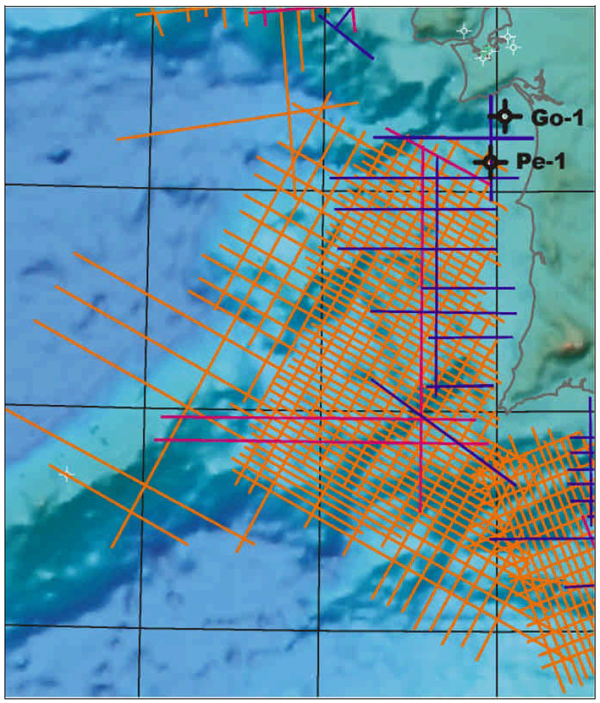
Only two wells have been drilled in the Alentejo Basin; one on the eastern flank of the basin (penetrating a thick Mesozoic carbonate platform) and the other one within a submarine channel system that allowed clastic sediments (transported by the paleo-Tejo River system that drained a large portion of Iberia) to bypass the carbonate platform into deepwater depositional systems.
Interpretation of modern, high quality, 2D regional seismic data has revealed a multitude of different untested play types in the basin. Total sedimentary thickness exceeds 10 km. Basin development is similar to that of the Jeanne d'Arc Basin, with the exception of a Tertiary compressive overprint. Structural styles range from extensional (tilted fault blocks) to transtensional (gentle rollovers, inverted sub-basins). Triassic salt domes also exist.
Potential source rocks have been projected from nearby explored basins; Upper Jurassic and Lower Cretaceous shale units are considered most important. Modeling indicates the source rocks to be mature for hydrocarbon generation. Oil-stained dredge samples, seismic hydrocarbon indicators, and satellite detected oil seeps confirm a live petroleum system. Potential reservoir units include carbonate build-ups in the shallow portion of the basin, shallow water sandstones, and deepwater clastic depositional units.
Several structural and stratigraphic leads have giant potential, many of these in water depths shallower than 2000 m..
|
|
SummaryThe Alentejo Basin is located south on the Atlantic Margin of Portugal, south of Lisbon (Figure 1). It extends over more than 30 000 km2 and grades into the Tagus Abyssal Plain. Interpretation of modern, high quality, 2D regional seismic data has revealed a multitude of different untested play types in the basin. The main seismic database (Figure 2) is composed of a 4 km x 8 km grid. Some reprocessed vintage data were also used. Total sedimentary thickness appears to exceed 10 km based on seismic interpretation and gravity data modeling. Basin development is similar to that of the Jeanne d'Arc Basin, with the exception of a Tertiary compressive overprint. Structural styles range from extensional (tilted fault blocks) to transtensional (gentle rollovers, inverted sub-basins). Triassic salt domes also exist. Only two wells have been drilled in the Alentejo Basin (Figure 3); Pescada-1 on the eastern flank of the basin penetrateed a thick Mesozoic carbonate platform and Golfinho-1 is on the flank of a submarine channel system that allowed clastic sediments (transported by the paleo-Tejo River system that drained a large portion of Iberia) to bypass the carbonate platform into deepwater depositional systems. Potential source rocks have been projected from nearby explored basins; Upper Jurassic and Lower Cretaceous shale units are considered most important. Modeling indicates the source rocks to be mature for hydrocarbon generation. Oil-stained dredge samples, seismic hydrocarbon indicators, and satellite detected oil seeps confirm a live petroleum system. Potential reservoir units include carbonate build-ups in the shallow portion of the basin, shallow water sandstones, and deepwater clastic depositional units. Examples of the seismic expression of carbonate build-ups are shown in Figure 4. Cretaceous and Tertiary deepwater depositional systems are recognized. Figure 5 is an isochron map (TWT) of such a unit. The map indicates a fill and spill depositional system in the southern portion. Several mapped structural and stratigraphic leads have giant potential. Many of these are located in water depths shallower than 2000 m. Once discoveries are made, fields can be put on stream; infrastructure is in place. |


