![]() Click
to article in PDF format.
Click
to article in PDF format.
A New Upper Oligocene Oil Play in Southern Burgos Basin, México*
By
Cuevas Leree, Antonio1, Rogelio Muñoz-Cisneros2, Pedro Silva-Saldivar2, Victor Hugo De la Rosa-R.2, Esmer O. Rivas-R.2, Jesus González-O.2, and Ramiro Fernández-Turner2
Search and Discovery Article #10077 (2005)
Posted January 27, 2005
*Adapted from extended abstract prepared for presentation at AAPG Annual convention, April 18-21, 2004.
1Activo Regional de Exploracion, PEMEX E&P, Poza Rica, Ver, Mexico
2Activo Integral Burgos. PEMEX E&P, Reynosa, Tamps, Mexico
Abstract
Discovery of oil in a new play has increased the petroleum potential of the Tertiary coastal plain in the southern part of the Burgos Basin. In this Upper Oligocene shoreface-sandstone play, the clastic succession is related to a deltaic system with sediments unrelated to the Rio Grande Embayment but related to uplifted terrains along the Sierra Madre Thrust Belt. Geochemical modeling indicates a Tithonian origin of the oil and generation in a “kitchen” adjacent to the discoveries, implying a few kilometers of migration of light oil (46° API) through pathways afforded by the listric faults that also contributed to formation of traps.
The intervals tested are fine-grained sandstones that have a gross thickness of 600 meters, at depths ranging from 2600 to 2900 meters below sea level. Porosity and permeability range from 11 to 17% and 0.5 to 21 millidarcys, respectively. Resistivity of sandstones typically is from 2 to 10 ohm-m. These rocks produce at estimated rates of 4000 bpd and 9 MMCMPD of gas. Original potential resource estimation of the prospect is close to 100 MMBOE. According to play analysis of the region, the Upper Oligocene play could have up to 5000 km2 of prospective area.
|
|
IntroductionThe study area is located in the southeastern part of the Burgos Basin (Figure 1). The exploration play for the Frio covers about 15,000 km2. The Nejo exploration area involved in the study is shown in Figure 1, as well as some of the most productive gas-fields of the eastern part of Burgos Basin. During the beginning of 2003, PEMEX (PETROLEOS MEXICANOS) started an exploration campaign in the southeastern part of the Burgos Basin called “Vicksburg-Frio Plays.” The objectives of these plays involve the clastic sequences of Frio Marino Formation and Vicksburg Formation (Middle-Lower Oligocene). Using 2-D seismic data, the first exploration well (Nejo) was located and subsequently drilled with an oil-base mud (OBM) system. This well resulted in the discovery of the field, with good production of light oil and gas from the Frio Marino Formation. Figure 2 illustrates the Cenozoic stratigraphic section and the position of the interval under study, the shallow-marine clastic sequences of the Frio Marino Formation (Middle Oligocene). General geological background studies of the Burgos Basin related to Cenozoic strata may be found in Echanove (1986) and Perez-Cruz (1992), among others. There are in existence other non-published studies of the area conducted for PEMEX.
General StratigraphyThe stratigraphic column of the study area above a Paleozoic basement of igneous, metamorphic, and volcano-clastic rocks consists of carbonates and marine evaporitic sequences of Mesozoic age overlain by a thick succession of Tertiary rocks (Figure 2), all with a maximum thickness of about 10 km in the deepest part of the basin. According to Perez-Cruz (1992) the Cenozoic strata has prograded, from the Paleocene to the Holocene, from west to east (basinward). Every shoreline from the Paleocene to Holocene has migrated in that direction, in accordance with the progradation of the Cenozoic clastic sequences into the Gulf of Mexico. The stratigraphic section under study is the shallow-marine clastic sequences of the Frio Marino Formation (Middle Oligocene) (Figure 2).
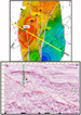
Structural FrameworkThe study area is located between two major synthetic listric faults that delimit the field (Figure 3a, 3b). The western fault has contributed to the creation of the rollover that forms the structure for the exploration test, and the eastern one formed later, simultaneously with the basinward migration of the Oligocene depocenter. Secondary synthetic normal faults affect the crestal area of the main rollover structure.
Reservoir RockBased on analysis of the well logs (OBMI images) and core samples, the lithofacies were identified and recognized in order to make an interpretation and propose a sedimentary model for the Frio Marino Formation. In combination with the structural deformation obtained from the 2-D seismic data, the model is intended to explain the nature and origin of this oil and gas accumulation and guide future plans in terms of well location and field development. The sandstone beds in this lithofacies, with light oil and gas, form the main reservoirs of the field (Figure 4). This low-resistivity lithofacies was recognized in several wells, and it is one of the most common and representative lithofacies encountered in the area of study. This lithofacies can be interpreted as having been formed in a nearshore and shelfal zone, as indicated by the Ophiomorpha ichnofacies (Figure 4) and the presence of benthic shallow-water foraminifera. Due to the thin-bed sandstone-shale interstratification in these reservoirs, conventional tools did not provide accurate representation. True resistivity in the productive zones appears to be low (10 ohm-m) due to the incorporation of clay layers that are not resolved by the conventional tools. Effective porosity obtained using high-resolution density (RHO8) and neutron (NPOR) cross-plots can reach as high as 25%. Gas saturation can reach 60%. These favorable reservoir features occur near the top of coarsening-up cycles related to the proximal-middle part of the flood-generated sandstone lobes. Total porosity of the sandstone beds from core plugs in well 4 range from 5 to 15%, with permeability of 0.02 to 4 md. Grain density from core samples has an average of 2.68 g/cm3.
Source RockModeling indicates that source rocks are Tithonian shales which normally yield low-gravity oil (18-22° API); however, light oil (46° API) is present. Therefore, secondary migration may have occurred over a long distance along pathways of the listric fault system where the traps are located to charge them with light oil (Figure 5).
AcknowledgmentsThis paper was made possible thanks to the invaluable help of the PEMEX Exploration Burgos authorities who released the data and allowed us the opportunity to develop this paper. Special thanks to geologist Marco Sanguinetti (Schlumberger-DCS, Reynosa) for substantial contributions.
ReferencesEchanove, Oscar, 1986, Geología Petrolera de la Cuenca de Burgos: Coordinación Regional de Exploración, Zona Noreste: Petroleos Mexicanos, v. 38, p. 3-69. Perez-Cruz, G.A., 1992, Estilos estructurales de la Cuenca de Burgos y sus perspectivas economicopetroleras (abs.): II Symposio Asociacion Mexicana de Geologos Petroleros, Instituto Mexicano del Petroleo, Mexico, D.F.
|