![]() Click
to presentation in PDF format.
Click
to presentation in PDF format.
Computer Simulation of Hydrocarbon Generation, Migration, and Accumulation under Hydrodynamic Conditions -- Examples from the Williston and San Juan Basins, USA*
By
Fred F. Meissner1 and Richard B. Banks2
Search and Discovery Article #40179
Posted November 10, 2005
*Oral Presentation at AAPG International Conference and Exhibition, October 15-18, 2000, Bali, Indonesia
1Colorado School of Mines, Golden, CO
2Scientific Computer Applications, Inc, Tulsa, OK ([email protected])
We have developed a PC-based program that uses basic data to identify and map an area of source rock maturity and the volumes of oil or gas it may generate, map secondary migration routes for generated hydrocarbons under hydrodynamic conditions, and predict the areas and volumes of hydrocarbon accumulation along a migration path.
Input data required for mapping the area of source rock maturity and generation volume includes kerogen type, organic carbon content, source rock thickness, kerogen transformation ratio, and amount of hydrocarbons retained in the source rock. Contour maps of these data are generated and integrated on the PC.
Input data required for mapping secondary hydrocarbon migration paths within a carrier/ reservoir unit charged by a mature source rock include datum elevations on top of the reservoir, pressure data, and reservoir fluid densities. Structure and groundwater potentiometric surface maps may be modified by a fluid density controlled "tilt amplification factor" to create "phantom" hydrocarbon-water contact (HWC) datum elevation contour map. The intersection of contours on the structure and phantom HCW maps may be used to create contours of equal hydrocarbon potential energy that control migration paths and sites of potential entrapment.
|
|
Technique and Advantages• Technique allows use of primary contour maps to generate secondary maps.• Primary maps may come from disparate data from different locations or sources.• One can use published contour maps for which no primary supporting data are available.Data Used to Generate Primary Maps• Source Rock Data:– Total Organic Carbon (TOC), Thickness, Kerogen Type, Maturity (Ro), Transformation Ratio, Solvent Extractables• Structural Data• Hydrodynamic Data– Pressures or Hydraulic Heads– Fluid DensitiesPrimary Contour Maps• Total Organic Carbon (TOC)• Thickness• Maturity (Ro)• Fraction Of Ultimate Generation (Transformation Ratio)• Non-expelled HCs• Structure Map• Potentiometric Surface Map In Reservoir/carrierBasic RelationsVg= A*T*TOC*Q*FWHEREVg = Volume Of Generated HCsA = Area, AcresT = Thickness, FeetTOC = Total Organic Carbon, FractionQ = Ultimate Yield, Bbl/acre-foot-Function of Kerogen TypeF = Ultimate Generation-Function of Source Rock Maturity (Ro)Ve = Vg - VneWHERE Ve = Volume of Expelled HCsVg = Volume of Generated HCsVne = Volume of Non-Expelled HCs
Volumes calculated by computer contouring and integration.
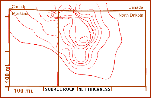
Williston Basin (Madison- Bakken Oil System) (Figures 1-12) Click to view sequence of Williston Basin maps (Figures 3-8, 11).
With Bakken Shale as source rock, Type II oil-generating kerogen yields 3200 Bbl/acre-foot (Figure 2).
Ultimate HC Generation PotentialGross Area (AC) = 25,000,000 Gross Volume (AC/FT) = 603,000,000 Net Volume (AC/FT) = 25,000,000
25,000,000 * 7758 * 3200/7758=80 Billion Barrels
Amount of Generated OilPresent day volume of oil generation is 32 billion barrels.Amount of Oil ExpelledVolume of expelled oil is 28.8 billion barrels.
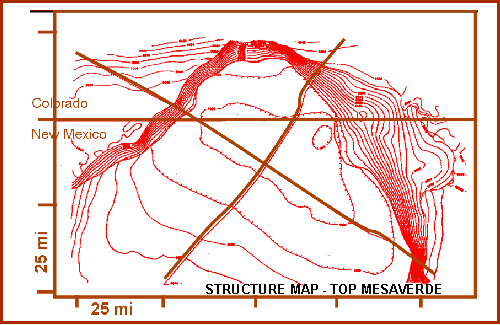
San Juan Basin (Mesaverde Gas System) Figures 13-19Click to view sequence of San Juan Basin maps (Figures 15-17). Hubbert’s Relation: Potentiometric Surface to HC-Water ContactDX/DY = TAF X DX/DZ WHERE TAF =
water density
BASIC RELATION: PEhc = TME - SE WHEREPEhc = Potential energy factor for HCTME = Tilt Map* contour elevationSE = Structure map contour elevationSummary and ConclusionsComputer assisted intercept solutions for contour maps of certain key parameters may be used to construct maps depicting generation, migration and accumulation patterns and amounts. |


