![]() Click to view article in PDF format.
Click to view article in PDF format.
General Levalle Basin, Argentina: A Buried Lower Cretaceous Rift*
By
Robert E. Webster1, Gualter A. Chebli2, and J. Fritz Fischer3
Search and Discovery Article #30022 (2004)
*Adapted from “extended abstract” for presentation at the AAPG Annual Meeting, Salt Lake City, Utah, May 11-14, 2003.
1Hunt Oil Company, Dallas, TX ([email protected])
2Phoenix Oil & Gas, Buenos Aires, Argentina ([email protected])
3FRS Geotech, Denver, CO ([email protected])
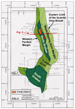
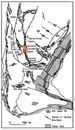
The General Levalle Basin is a long, narrow, and deep Lower Cretaceous intracratonic rift basin buried beneath the southern Pampean plains in southern Cordoba province, Argentina. The basin trends approximately north-south for over 150 km, ranges from 5 to 50 km wide, and is over 6500 m deep. Below a prominent Upper Cretaceous unconformity, mantled by an unstructured Pleistocene through Upper Cretaceous clastic sequence, steeply dipping normal faults bound tilted graben and half-graben fault blocks (Figure 1). Major basin-bounding faults are part of a longer regional zone of crustal weakness that extends from the western Colorado basin in a north-northwesterly direction through the Macachin and General Levalle basins, the eastern Pampean Ranges west of Cordoba, and probably as far north as the Northwest Cretaceous basin (Figure 2). In 1995-96, Hunt Oil Company drilled the Cd. GL x-1, the first well in the basin, to 5179 m to test the petroleum potential of the basin.
|
|
The General Levalle rift basin fill is the fault-bounded interval truncated by a prominent unconformity of late Aptian or younger age. As defined in the Cd. GL x-1 well, the Lower Cretaceous section can be divided into two main stratigraphic units: a very thick (over 3200 m) lower sedimentary sequence, here named the General Levalle Formation, and an overlying 815 m thick section of basalt flows and sills with some interbedded sedimentary units, named the Guardia Vieja Formation (Figures 3 and 4). The General Levalle Formation is a Valanginian-Hauterivian-aged clastic-evaporite package deposited in an arid, restricted, temperate-zone, rift basin which included a hydrologically-closed saline lake. It is in part analogous to inverted Lower Cretaceous rift basin sections that crop out in the Sierras Chicas and Sierra del Gigante to the north and west. The formation contains nine lithology-based members representing one continuous cycle of deposition, with a lower coarse-clastic sequence gradually fining upward into an evaporite member and then coarsening upward again to an upper sandstone. The deepest unit drilled in the basin is the Lower Sandy Siltstone Member. This is dominantly a grayish to reddish brown sandy siltstone, over 82 m thick, with interlayered dirty gypsum/anhydrite, sandstone, and some claystone. Underlying the Lower Conglomerate Member, this unit probably represents a temporary reversal in grain size in the overall fining-upward sequence of the lower General Levalle Formation. A basal coarser clastic member is expected to underlie the sandy siltstone above the undrilled basement rocks of the rift floor. The Lower Conglomerate Member is a 230-m-thick, reddish-brown, lithic arkose conglomerate, tightly cemented by anhydrite and dolomite. It is interpreted as a coarse alluvial fan complex that built out from highlands or fault scarps that existed along the rift basin margins. It is overlain by the Lower Rift Sandstone Member, 181 m thick, in which lower reddish-brown conglomeratic sandstone grades upward to very fine-grained arkosic sandstone at the top, with some interbedded dark gray to black shale and anhydrite occurring in the upper part. The unit is interpreted as sandy lower fan material, interbedded in part with playa-lake anhydrite and shale layers. The only hydrocarbon show in the well was from a 1-m interval at 4697 m, where a minor gas show was associated with a bitumen-stained tight sandstone bed under capping dark gray shale. The Lower Rift Siltstone Member overlies the sandstone. It is grayish brown, of varying hardness and is characterized by an inordinately high amount of biotite. It also contains abundant gypsum, some clean and white, and some mixed with silt and clay in what may be micro-chicken wire structures. This indicates a classic playa-lake environment, with the groundwater table at or just below the surface. Detrital clasts of glauberite in some of the cuttings indicate that there was a hypersaline lake somewhere nearby in the basin. The middle part of the General Levalle Formation is characterized by the massive Evaporite Member, 681 m thick in the wellbore. The lower part is a series of evaporite beds of varying mineralogy, including halite, thenardite, glauberite, anhydrite, gypsum, vanthoffite, calcite, possibly loeweite, and other unidentified minerals with lesser siltstone and claystone. An igneous sill of biotite microdiorite, 58.5 m thick, cuts this section. Above the sill is a massive evaporite interval 338.5 m thick, which appears to be almost entirely thenardite. Finally, the upper part consists of interbedded halite, sylvite, and possibly other evaporite minerals, including gypsum, with layers of siltstone similar to that in the overlying member. The age of the Evaporite Member is well constrained by abundant gymnosperm palynomorphs of the Cyclusphaera-Callialasporites assemblage as being Early Cretaceous (Hauterivian/Valanginian) in age. This is the same assemblage observed in the overlying and underlying units, but the Evaporite Member has richer and more diverse microfloral content. The dominant gymnosperm pollen was probably blown into the evaporite pan or lake from relatively nearby forests, but there is no flora to indicate the presence of swamps or other fresh-water wetlands. Rather, as indicated by the thick evaporite deposition, the climate was quite arid during this time. Above the evaporites, the Lower Gypsiferous Siltstone Member represents a return to clastic lake-margin deposition. The unit is 298 m thick, and the prominent ‘‘Orange’’ seismic marker ties to the approximate top. The rocks are grayish-brown to reddish interbedded silty claystone, clay-rich siltstone with abundant biotite, and claystone, all with gypsum. The gypsum intervals are white to medium brown, depending on the purity of the gypsum layers. The overlying 228-m-thick Arkosic Sandstone Member is grayish brown, moderately sorted, mostly fine-grained, and arkosic with abundant biotite. Sandstone and interbedded siltstone are hard and tightly cemented with anhydrite and dolomite, with some quartz and feldspar overgrowths and solution. This member is interpreted as representing alluvial-fan deposition, resulting from fans migrating farther into the basin in a similar manner to the Lower Rift Sandstone and Lower Conglomerate members. The Arkosic Sandstone grades upward into the Upper Gypsiferous Siltstone Member, 847 m thick, which is lithologically very similar to the deeper Lower Gypsiferous Siltstone and represents a return to essentially the same playa-margin depositional environment, with a retreat of the alluvial fans. Finally, the uppermost section is the Upper Rift Sandstone Member. This is a true redbed sandstone, 305 m thick, and unlike all the underlying members, it retains good porosity. It is arkosic in composition with quartz, abundant plagioclase feldspar, biotite, minor hornblende, and rare muscovite. Thin interbeds of reddish brown claystone and silty claystone occur. This is definitely a rift-fill sediment, interpreted to have formed on the distal portion of an alluvial fan, probably by ephemeral braided streams. The member could not be dated, although it must be between Hauterivian/Valanginian and Aptian. The uppermost rift fill sequence, the Guardia Vieja Formation, is a series of basalt flows and sills over 800 m thick with some reddish-brown sandstone and claystone interbeds. The basalt has characteristics typical of alkali-olivine basalts, which are commonly found in rift basins, rather than of tholeiites, which are the usual flood basalts. Cuttings were dated by K/Ar method as 110 +/- 6 Ma, indicating the basalt was emplaced during Aptian time. In both composition and age, the Guardia Vieja Basalt more closely resembles outcropping rift-related basalts in the Pampean Ranges than the better known Serra Geral flood basalt in northern Argentina and Brazil. A major unconformity cuts the Guardia Vieja Basalt, above which an unstructured Upper Cretaceous to Pleistocene section overlies the buried rift basin. This includes the redbed sandstones of the Upper Cretaceous Tacuarembó Formation, 809 m thick, and a group of Tertiary-Quaternary sandstones and shales that dip regionally eastward toward the Atlantic.
Most faults terminate at or below the post-Aptian unconformity (Figure 4). Regional considerations and internal fault/fold alignment indicate that the steeply dipping faults had a component of transcurrent movement as well as the obvious normal component. The overall geometry of the basin suggests two rhomboid grabens linked by a transfer zone along a dextral wrench fault zone (Figure 1). At both the north and south ends, seismic shows that the basin floor rises and the margin faults converge. Basin geometry was delineated by gravity and by two seismic programs totaling 1532 line-km. In the absence of well control, many assumptions were made regarding the sedimentary fill, and the great thickness of Lower Cretaceous strata was unexpected. Due to narrowness of the basin and to rapid facies changes, it was difficult to carry reflectors throughout the area with any confidence. The deepest coherent reflector, or seismic basement, proved to correspond to the top of the Lower Rift Siltstone Member. Within the trough of the northern General Levalle rift, the reflector corresponding to the top of the Lower Gypsiferous Siltstone Member could be followed and mapped over the broadest area, but it could not be carried reliably into the southwestern part of the basin. Two anticlinal features were mapped at this horizon, including the drilled General Levalle prospect.
Although the basin-center Evaporite Member is an ideal seal, only one very minor show was detected on the General Levalle structure. Below the Upper Rift Sandstone Member, dolomite, anhydrite, or other evaporite minerals tightly cement all sandstones, and both primary and secondary porosity are lacking. Only the Upper Rift Sandstone and the Tacuarembo´ Sandstone are of reservoir quality, but these lack both adequate seals and trapping geometries. No source facies were identified. The section is dominated by oxidized redbed lithologies, and only the dark gray to black shale beds in the upper Lower Rift Sandstone had the appearance of source potential. These proved to be very lean, with TOC’s mostly below 0.3% and only a few samples in the 0.5 to 1.0% range. Maturity below the evaporites was in the wet gas window. Given the narrow, deep depocenter, unfavorable reservoir-seal relationships, and the lack of source facies, an effective petroleum system remains unproven in the basin and is unlikely to exist.
Schmidt, C. J., R. A. Astini, C. H. Costa, C. E. Gardini, and P. E. Kraemer, 1995, Cretaceous rifting, alluvial fan sedimentation, and Neogene inversion, southern Sierras Pampeanas, Argentina, in Tankard, A. J., Suarez, S. R., and Welsink, H. J., eds., Petroleum Basins of South America: AAPG Memoir 62, p. 341-358. |