![]() Click to view article in PDF format.
Click to view article in PDF format.
A Cretaceous Allochthonous Evaporitic Province within the Betic-Maghrebian Domain: Comparison with the present-day Gulf of Mexico*
By
Joan Francesc Flinch1
Search and Discovery Article #30025 (2004)
*Adapted from “extended abstract” for presentation at the AAPG International Conference, Barcelona, Spain, September 21-24, 2003.
1TotalFinaElf, Pau, France
Abstract
Field, seismic, and well-log data suggest that most of the Triassic of the external domain of the Betic-Maghrebian domain of the Western Mediterranean is allochthonous. Allochthonous Triassic is much more abundant in the Guadalquivir Allochthon (i.e., Westernmost Sub-Betic realm) of the Betic Cordillera than in the Rif. Triassic evaporites are directly in contact or imbedded within Upper Cretaceous-Paleogene deep-water sediments, and the Jurassic is absent. In the Rif Cordillera the so-called "marnes a gypse” suggest evaporitic re-sedimentation within the actual Prerifaine Nappe. Along the Central Rif, exploration well BB-1 encountered several-meters-thick Triassic breccia that constitute the basal detachment of the area. Farther east in Algeria and Tunisia, several Triassic " salt glaciers " emplaced during Albian to Turonian time have been described along the Tell Cordillera. Restoring the lateral displacement of Africa and Iberia, the Betic and Maghrebian (i.e., Rif and Tell Cordilleras) passive margins were facing each other during Triassic and Jurassic times. During Neogene time after the emplacement and collision of the Alboran Block, the allochthonous evaporitic province was dismembered and thrusted onto the pasive margins of Iberia and North Africa. The Gulf of Cadiz and the Prebetic Zone represents the only preserved segments of the south Iberian Mesozoic passive margin. All these observations suggest that during Cretaceous time the South Iberian and North African margins resembled the present day Gulf of Mexico. Therefore the Betic, Rif, and Tell Cordilleras could provide field analogs of exploration of allochthonous salt provinces.
|
uComparison with Gulf of Mexico
uComparison with Gulf of Mexico
uComparison with Gulf of Mexico
uComparison with Gulf of Mexico
uComparison with Gulf of Mexico
|
IntroductionField, seismic, and well-log data suggest that most of the Triassic of the external domain of the Betic-Maghrebian domain of the Western Mediterranean (Figure 1) is allochthonous. Allochthonous Triassic is much more abundant in the Guadalquivir Allochthon of the Betic Cordillera than in the Prerifaine Nappe of Morocco. Triassic evaporites are directly in contact or intermixed with Upper Cretaceous-Paleogene deep-water sediments, and the Jurassic is absent. The structure of the External domain of the Betic, Rif, and Tell Cordilleras is the result of piggy-back sequence of emplacement; that is, the upper units were emplaced first, and the later emplacement of the lower units deformed the uppermost ones from underneath. The first unit to be emplaced was the accretionary wedge (i.e., Guadalquivir and Prerifaine Nappe), and the passive-margin units were emplaced afterward. This evolution resulted in the presence of numerous tectonic windows of passive-margin units (i.e., Jurassic and Lower Cretaceous) surrounded by intermixed Triassic and pelagic Upper Cretaceous and younger sediments.
Allochthonous Triassic EvaporitesWestern Betic CordilleraThe thickest allochthonous Triassic evaporitic section was encountered by well Bornos-1, which drilled 2500 m of Triassic salt. Farther west, in the Jerez de la Frontera region, well Betica 18-1 encountered 1500 m of allochthonous Triassic salt within the Guadalquivir Allochthon, detached from Sub-Betic Maastrichthian shale (Figure 2). This well also encountered sub-autochthonous Triassic salt, dolomite, and anhydrite. Farther north, well Betica 14-1 located along the Guadalquivir valley drilled several hundred meters of Triassic salt imbedded within Miocene marls of the Guadalquivir Allochthon (Figure 2). The Guadalquivir Allochthon involves Upper Cretaceous deep-water pelagic facies "Capas Rojas" and deep-water pelagic marls with radiolarians. Pelagic deposits are mixed with Triassic evaporites, mainly gypsum and salt, shales, siltstones, and occasional sandstones. Upper Cretaceous deep-water sediments above a low-angle detachment systematically overlie Triassic evaporites and shales.
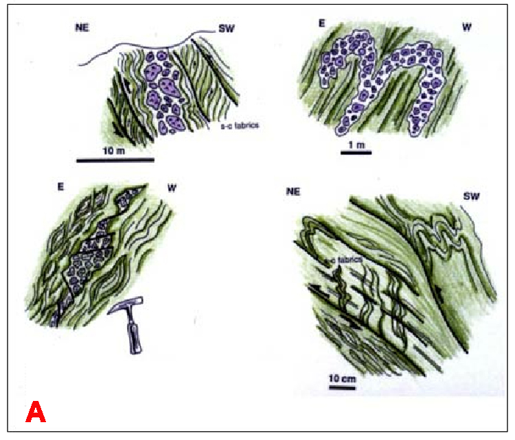
Central Betic CordilleraThe Guadalquivir Allochthon thins out towards the Central Betic Cordillera mainly occupied by the Sub-Betic thrust sheets, characterized by a thick Jurassic section encountered by Nueva Carteya-1 and Fuensanta de Martos-1 wells (Lanaja 1987). Triassic sediments constitute kilometric-scale thrust sheets to centimetric or decametric blocks imbedded within Cretaceous-Paleogene marls (Figure 3). At a mesoscopic scale the structure of the Triassic is characterized by multiple decollement tectonics, disharmonic folding, s-c type shear fabrics, and gypsum cracks. Resedimentation processes and slumps are common within the section, very well exposed near Jodar (Jaén) and Huelma (Granada) (Figure 3). These observations suggest that Triassic evaporites were emplaced during Upper Cretaceous time in a deep-water setting.
Prerifaine Nappe Rif Cordillera (Morocco) The Prerifaine Nappe of the Rif is the equivalent of the Guadalquivir Allochthon and represents an Accretionary Wedge (Flinch 1993). Often Triassic shales and evaporites (mainly gypsum) are intermixed with deep-water Upper Cretaceous marls; these deposits are referred to locally as "marnes à gypsum." Locally these sediments have a breccia character, including blocks of metamorphic and igneous rocks and are referred to as "brèche polygénique à matrice gypseuse." These deposits are well exposed in the Ouerha valley of the Central Rif (Asebriy et al., 1987). Lower Eocene sediments unconformably overlie Triassic evaporites, suggesting that the emplacement was already completed at that time. In the south-central Rif, Had-Kourt-Teroual area, well BB-1 encountered two Triassic breccia levels 20 and 67 meters thick, which represent the basal detachment of the Prerifaine Nappe detached from the Jurassic Imbricates (Service Geologique du Maroc, 1984 and 1990). Along the Rharb Basin, Triassic shales and evaporites are imbedded within Cretaceous marls of the Prerifaine Nappe. The exposed Triassic Ridge of Souk el Arba and the Triassic-Cretaceous imbricates of El Fokra-1 well are examples of this type of "mélange."
"Zone des Domes" Tell Cordillera (Algeria and Tunisia) Mostly field studies in Algeria and Tunisia (Vila 1995) suggest that Triassic "salt glaciers" were emplaced during Turonian and Albian time, slightly earlier than in the Betic Cordillera. Even though the allochthony of the Triassic salt glaciers of the "Zones des Domes" Algeria and NW Tunisia is still subject of debate, published data indicate that the Triassic reached an early or advanced tongue stage (in the sense of Wu et al., 1990) and perhaps only exceptionally reached the allochthonous sheet stage like in the Betic Cordillera. Farther east in Tunisia the front of the Téboursouk unit separates these tongues from the more proximal diapirs (Vila et al., 1999).
Comparison with the Gulf of MexicoThe Triassic evaporites of the Betic, Rif, and Tell Cordillera are interpreted as passive margin-type allochthonous evaporites emplaced during passive margin stage (before Neogene compression) in a similar way to that of the allochthonous salt of the Gulf of Mexico. Reworked Triassic salt and gypsum (i.e., blocks and slumps) within the pelagic Mesozoic section support this hypothesis. This hypothesis would help to explain the presence of large volumes of Triassic sediments within the Guadalquivir Allochthon as well as the absence of Jurassic strata. In the offshore Louisiana area, however, the Sigsbee salt nappe can reach a thickness of around 7 km and a length of about 200 km (Worall and Snelson, 1989); that contrasts with the dimensions of the evaporitic sheets of the Guadalquivir Allochthon that reaches at least 2.5 km in thickness in the Western Betic Cordillera, but the value is difficult to evaluate because of erosion. The allochthonous Triassic occupies the external zones of the Western and Central Betic Cordillera, extending for more than 200 km. While the allochthonous evaporites of the Gulf of Mexico consist mostly of salt and are Jurassic in age, the ones of the Betic Cordillera are Triassic and apart from salt include also gypsum, anhydrite, and shale. Omissional contacts between Triassic and Cretaceous or Paleogene pelagic sediments, with locally preserved roll-over structures, are the most widespread evidences of extensional mini-basins overlying the allochthonous Triassic of the Betic Cordillera. While in the Gulf of Mexico, supra-allochthonous salt withdrawal basins (i.e., mini-basins) and related extensional systems are always preserved, in the Betic Cordillera they are inverted, carried piggy-back on the Guadalquivir Allochthon and strongly deformed due to Neogene compression.
Triassic half-grabens superimposed on the Hercynian basement of the Iberian Meseta represent the initial rifting of the margin. Moguer-1, Villamanrique-1, and Casas Nieves-1 wells in the Guadalquivir Basin and well KC-1 underneath the Rharb Basin encountered Triassic red beds filling half-graben structures overlying the Hercynian Basement, discordantly covered by evaporitic deposits that thickened towards the Tethys (SSE). A widespread Lower Jurassic carbonate platform occupied the south Iberian margin. The carbonate platform was broken up during Middle Jurassic time, and the region became an Atlantic-type passive margin. Allochthonous salt deposits may occupy distal positions of passive margins. A tentative hypothetical reconstruction of the External zones of the Central Betic Cordillera suggests northward displacement of the Guadalquivir Allochthon on the order of 200 km (Flinch et al., 1996). Conventional Cretaceous paleogeographic reconstructions of North Africa and South Iberia do not consider the allochthonous Triassic evaporitic province that probably occupied the Western Tethys. Reconstructing the location of the Iberian plate, Algeria and Tunisia were facing the Sub-Betic area, before the lateral westward displacement of Iberia. The proximal part of the South Iberian margin, relatively undeformed, can be studied in the Eastern Pre-Betic Cordillera, Alicante region, and the northwestern Gulf of Cadiz, where the most incipient and proximal Triassic diapiric stage associated with listric normal faulting can be still seen. In a similar paleogeographic position in the North African side of the margin are located the Rides Prerifaines and the Guercif Basin of Morocco. The "Zones des Domes" of Algeria and NW Tunisia, representing a more distal stage of Early and Advance Tongue stages (Wu et al., 1990), do not reach the Allochthonous sheet stage with overlying withdrawal basins that existed and were incorporated later onto the Guadalquivir Allochthon.
References CitedAsebriy, L., De Luca, P., Bourgois, J., and Chotin, P., 1987, Resédimentation d'âge sénonien dans le Rif central (Maroc): Conséquences sur les divisions paléogéographiques et structurales de la chaîne: Journal of African Earth Sciences, v. 6, p. 9-18. Flinch, J. F., 1993, Tectonic evolution of the Gibraltar Arc: Unpublished Ph. D. thesis dissertation, Rice University, Houston, Texas. Flinch, J. F., Bally, A. W., and Wu, S. 1996, Emplacement of a passive-margin evaporitic allochthon in the Betic Cordillera of Spain: Geology v. 24, no. 1, p. 67-70. Lanaja, J. 1987, Contribución de la exploración petrolífera al conocimiento de la geologia de España: Instituto Geológico y Minero de España, Madrid, 465 p. Vila, J. M. 1995, Première étude de surface d'un grand "glacier de sel" sous-marin: l'est de la structure Ouenza- Ladjebel-Méridef (confins algéro-tunisiens). Proposition d'un scénario de mise en place et comparaisons: Bulletin de la Societe Geologique de France, v. 166, no.2, p. 149-167. Wu, S., Bally, A. W., and Cramez, C., 1990, Allochthonous salt, structure and stratigraphy of the northeastern Gulf of Mexico, Part II: Structure: Marine and Petroleum Geology, v. 7, p. 334-370. |