![]() Click to view presentation in PDF format.
Click to view presentation in PDF format.
Sequence Stratigraphy of Isolated Carbonate Buildups in a Deltaic Province, Kutei Basin, East Kalimantan, Indonesia*
By
Arthur H. Saller1, Jesse T. Noah1, James C. Waugaman1, and Alif Prama Ruzuar2
Search and Discovery Article #30014 (2003)
*Adapted from “extended abstract” for presentation at the AAPG Annual Meeting, Houston, Texas, March 10-13, 2002.
1Unocal Corporation, Sugar Land, TX ([email protected])
2Unocal Indonesia, Balikpapan, Indonesia
The Kutei basin has been dominated by clastic deposition during the Neogene; however, isolated carbonate buildups are also common in Lower Oligocene to Holocene strata. In general, isolated carbonates accumulated during trangressions when the locus of clastic deposition shifted landward. Carbonate buildups preferentially occurred on structural highs and margins of lowstand deltas. In the western Kutei basin, the Kerendan carbonate platform is 1000 m thick and 10-20 km across. The Kerendan platform (Figure 1) built up during a series of Oligocene transgressions.
Carbonate Buildups in Pliocene-Holocene Sequences
North of the Mahakam delta, isolated carbonate buildups are common in Pliocene to Recent strata (Figures 1 and 2). Those isolated carbonate buildups have been imaged by 3D seismic data. North of the Mahakam delta, shelf margins prograded basinward during most of the Miocene, but they have generally been stepping back landward during the Pliocene and Holocene due to decreased clastic sediment supply and structural downwarping. Carbonate buildups are common in these backstepping strata. The transgressive systems tracts of two Lower Pliocene sequences contain carbonate buildups that grew immediately landward of the underlying lowstand shelf margin (Figures 3, 4, and 5). Those shelf-margin buildups are typically 100 m thick, 5 km long, and 1 km wide, with long directions parallel to the underlying lowstand shelf margin. Most of the carbonate buildups are overlain by prograding clastics which downlap onto the carbonate buildups (Figures 3 and 5). Progradational clastic packages contain both highstand and lowstand systems tracts which are difficult to separate. A few conical carbonate buildups occur to the north, away from the main clastic influx (Figure 6). Those conical buildups contain multiple stacked carbonate sequences that were not interrupted by clastic deposition.
Isolated carbonates are also present in the transgressive parts of Pleistocene and Holocene sequences (Figures 7, 8, and 9). The latest Pleistocene carbonate buildups can be mapped using the waterbottom reflector from 3D seismic surveys (Figure 2). Pleistocene carbonate buildups vary from 10 m to more than 100 m in thickness and preferentially occur on lowstand shelf margins and the upthrown side of faults (Figures 7, 8, and 9). Accommodation space created by middle shelf growth faults promoted carbonate deposition on the outer shelf by capturing large amounts of clastic sediment, thereby decreasing clastic influx to the outer shelf (Figure 8). Most Pleistocene carbonate buildups are also overlain by prograding prodelta shales, and the contacts are downlap surfaces. Carbonate buildups apparently drowned or at least quit growing because of rapidly rising sea level and/or poisoning (possibly nutrient-poisoning) associated with approaching deltas.
 Figure
1. Map of Borneo showing major deltaic basins, location of Kerendan
platform,and the main study area north of the Mahakam delta.
Figure
1. Map of Borneo showing major deltaic basins, location of Kerendan
platform,and the main study area north of the Mahakam delta.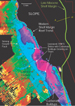 Figure
2. Northern shelf bathymetry from the 3D seismic waterbottom reflector.
Yellow areas are highest, and approximately 50 m deep.
Figure
2. Northern shelf bathymetry from the 3D seismic waterbottom reflector.
Yellow areas are highest, and approximately 50 m deep. Figure
4. 3D image of carbonate buildups in the upper interval of lower
Pliocene shelf margin carbonates north of the Mahakam delta.
Figure
4. 3D image of carbonate buildups in the upper interval of lower
Pliocene shelf margin carbonates north of the Mahakam delta.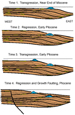 Figure
5. Stratigraphic model for uppermost Miocene and lower Pliocene shelf
margin strata north of the Mahakam delta.
Figure
5. Stratigraphic model for uppermost Miocene and lower Pliocene shelf
margin strata north of the Mahakam delta. Figure
6. Conical carbonate buildup
Figure
6. Conical carbonate buildup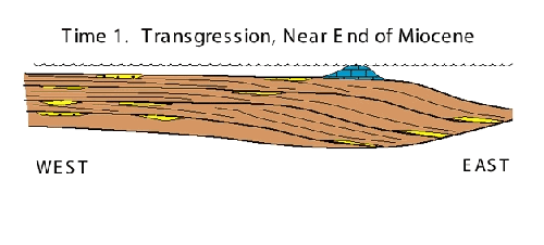