![]() Click to view article in PDF format.
Click to view article in PDF format.
By
William McBee, Jr.1
Search and Discovery Article #10055 (2003)
*Adapted from oral presentation at AAPG Mid-Continent Section Meeting, October 13, 2003.
1Consulting geologist, Tulsa, Oklahoma ([email protected])
The Nemaha zone is about 400 mi in length, extending south-southwest from the “Nemaha Mountain Structure” in southeastern Nebraska and northeastern Kansas, across Kansas and northern Oklahoma, then south into central Oklahoma, where it splays-out and terminates against the Oklahoma megashear in southern Oklahoma. The uplift in Nebraska-Kansas is a buried, high-relief basement block, bounded on the east by the near-vertical, 2500-ft Humboldt (Nemaha) fault. The zone varies in width from about 4 to 15 mi, with anastomosing patterns; it is commonly a single fault in central Oklahoma. Vertical displacement, the sense of which reverses along its trace, is generally up to several hundred feet, although it is 2500 feet in three places.
The Nemaha zone is regarded here primarily as a rather narrow transpressional fault zone that in Oklahoma experienced initial movement at least as early as Middle Ordovician (Taconian). It may have originated much earlier. Basically, it is a wrench-fault zone of limited horizontal displacement, where fault separation along the trace changes in a number of places from high-angle normal to high-angle reverse, and where it is associated with pull-apart grabens and/or horst (pop-up) structures.
East of, and parallel to, the Nemaha zone in Oklahoma are a number of less prominent fault trends and related structures. Some provide evidence of strike-slip displacements during deposition. These faulted structures, like those along the Nemaha zone, provide traps for oil and gas fields, including some giants.
|
|
Click to view sequence of structural contour maps on top Precambrian and Upper Pennsylvanian.
The Nemaha zone trends north-northeast through Kansas and north, with westward convexity, through most of Oklahoma. It is bounded on the north by the Central Plains Megashear and on the south by the Oklahoma Megashear (Figure 1), composed of major faults of the Arbuckle and Amarillo-Wichita-Criner Hills uplifts. Both megashears are northwest-trending and left-lateral, and episodic movements along them probably extended from Middle Proterozoic to Late Paleozoic. The area east of the Nemaha zone in Oklahoma exhibits several north- to north-northeast-trending strings of en echelon surface faults, which are oriented northwest-southeast (Miser, 1954). These are thought to be manifestations of strike-slip faults, along which are many oil- and gas-bearing structures. At the top of the Precambrian basement and also at the level of Upper Pennsylvanian strata, the west-dipping, gentle homocline over much of eastern Kansas is split, but little disturbed, by the Nemaha zone (Figures 2 and 3), even though some of the pop-up horst-blocks in the zone display over 1600 ft of vertical displacement. At the Nemaha uplift in northeastern Kansas, the fault is high-angle, reverse, and down-to-the-east with 2500 ft of throw (Carlson 1970). Across most of Kansas, the fault is generally down-to-the-east. Many of the horst-blocks in southern Kansas were elevated sufficiently for post-Mississippian erosion to remove over 1000 ft of Lower Paleozoic strata and expose the Precambrian basement, which was later overlain by Middle and Upper Pennsylvanian strata. Near the Oklahoma line, vertical displacement decreases and reverses to down-to-the-west. This feature is typical in Oklahoma, except in a few local areas where highly elevated pop-up structures are associated with down-to-the-east reverse faults.
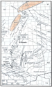
Examples of Local Structures within Nemaha Zone and Associated Fault Trends The giant El Dorado oil field, in Butler County, southeastern Kansas, was discovered in 1915 as a surface feature. It is about 15 miles long and 9 miles wide, bounded on the east by the Nemaha fault (Figure 4). This feature apparently formed as a transpressional (pop-up) structure during the post-Mississippian hiatus when several thousand feet of strata were eroded. Reeves (1929) noted that approximately 1400 feet of “Siliceous Lime” (Cambro-Ordovician Arbuckle) were removed. “Cherokee” (Middle Pennsylvanian) strata overlie eroded Arbuckle. The field has produced over 400 million barrels of oil.
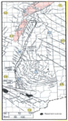
The Garber area, north-central Oklahoma, is characterized by a pop-up block with an associated graben (related to a releasing bend or representing a pull-apart “basin”) (Figure 5). This area is thought to offer the best evidence for right-lateral strike-slip movement along faults of the Nemaha zone. By Early Pennsylvanian, when there was erosion of the Garber structure, the stratigraphic throw, based on the top of the Mississippian “lime,” could have been as much as 3100 feet. Over 1000 ft of strata, ranging in age from Late Mississippian to Middle Ordovician, were removed by post-Mississippian erosion. The top of the Mississippian “lime” in the graben is more than 1600 feet lower than it is on the eroded upthrown east block and over 900 feet below it in the west block. The east-bounding fault is a reverse fault, down-to-the-east. The graben has preserved in it more than 200 feet of Lower Pennsylvanian clastics and over 400 feet of Upper Mississippian Chesterian oil-bearing strata that was stripped from both upthrown flanking blocks during Early Pennsylvanian erosion. This graben had been known for nearly forty years, but condemned by the industry because it was “low,” before a detailed study resulted in the completion of ten wells with new reserves in the Manning zone of the preserved Chesterian interval in the graben. To the north and south of the Garber structure, the net vertical displacement is down-to-the-west. Most of the strike-slip movement is thought to have occurred in Pennsylvanian time, when fault separation was reverse (Figure 6). Normal separation occurred in the Permian, with arching of the strata over the fault block and thereby forming the present trap for the more than 65 million barrels of oil that have been produced since 1949. The interval from the Pennsylvanian Hogshooter to the top of the Mississippian “lime” is about 840 feet thicker in the graben than in the upthrown blocks to the west and east (Figure 7). The earliest identifiable movement along the Nemaha zone was in Middle Ordovician time, as indicated by a 25% increase in the thickness of the Viola Limestone in the Garber graben, compared to the upthrown flanks. Its latest movement was in Middle Permian time.
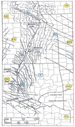
The Oklahoma City uplift has a structural history, geometry, and position similar to that of Garber and El Dorado. It is a highly upthrown, pop-up, reverse fault block that formed within the Nemaha zone. The east-bounding fault is down-to-the-east (Figure 8), although to the north and south, the relative displacement is down-to-the-west. Post-Mississippian erosion removed approximately 2000 feet of Mississippian, Devonian, Silurian, and Ordovician strata. Upper Middle Pennsylvanian deposits overlie eroded Arbuckle over the crest of the structure. According to Gatewood (1970), maximum throw of the Oklahoma City fault is 2400 feet, and the fault is very straight, generally normal or vertical, but apparently high-angle reverse in some sectors. Discovered in 1926, the field has produced over a billion barrels of oil. South of the Oklahoma City uplift, the Nemaha zone is accentuated with the development of several north-northeast- to northwest-trending vertical faults with very large down-to-the-west displacements. This pattern for the Nemaha zone continues to the south, where it splays-out against the Oklahoma Megashear. The Nemaha faults were contemporaneous with rapid subsidence of the Anadarko basin immediately to the west; both elements during the Pennsylvanian Desmoinesian were affected by strong movements along the Oklahoma Megashear. This area south of Oklahoma City contains the fabulous Golden Trend, which will produce well over 500 million barrels of oil from strata of mid-Desmoinesian and Ordovician age, mostly trapped against the Nemaha faults.
The Jennings area, northeastern Oklahoma, is situated along the en echelon Whitetail fault trend east of the Nemaha zone (Figure 1). The structure includes a severely faulted graben, which is bounded by left-lateral faults (Figure 9). The Desmoinesian interval is 100 feet (25%) thicker in the graben than it is in the west-flanking block. Movements along the fault during the Pennsylvanian probably occurred over a period of 5-10 million years. Jennings, like the Garber area, represents a case where the structure (in the graben) was known to be low and correspondingly was “condemned” for 30 years before the development of eight new wells that resulted in additional reserves.
Cushing field, south of the Jennings feature, is on the same Whitetail strike-slip fault trend. The controlling fault bounds the structure on the east and is down-to-the-east (Figure 10). It is a high relief, pop-up structure with essentially the same history as the Oklahoma City, Garber, and El Dorado structures, and with Middle Pennsylvanian strata overlying deeply eroded Arbuckle on its crest. Similar to the map of the El Dorado structure (Figure 4), the fault was not shown by Weirich (1929) as part of the contouring procedure (Figure 10). This field has produced more than 600 million barrels of oil since its discovery as a surface feature in 1916.
The Wetumka area, east-central Oklahoma, is located southeast of Jennings and Cushing on an en echelon fault trend east of the Whitetail trend. It is very similar to Jennings in that a narrow graben formed as a part of the overall structure (Figure 11). The Pennsylvanian sequence here is considerably thicker than at Jennings due to its more basinward position. Desmoinesian strata in the graben are about 15% thicker than on the flanks due to deposition during fault movement.
The chronology and geometry of the Nemaha fault zone is well documented by data from the hundreds of wells drilled in oil fields situated in and adjacent to the zone in Kansas and, especially, in Oklahoma. The earliest known movement of the Nemaha zone occurred during the Ordovician, although it may have originated at the same time as its terminating faults, i.e., in Middle Proterozoic. Along its entire length, the Nemaha fault surfaces are vertical or near-vertical, as determined from many closely spaced wells and seismic data. Along its trace, the directional sense of throw is reversed in several segments. Additional evidence for a major strike-slip fault zone consists of the presence of restraining and releasing bends (pop-up horsts and pull-apart grabens, with syntectonic stratal thickening, respectively) and splaying at both ends into its terminating megashears. The Nemaha zone is the result primarily of transpressional stresses acting episodically over a very long time. Right-lateral, strike-slip movement is thought to be especially well documented in the Garber field area. For comparison, transpressional horst blocks, transtensional grabens, and numerous large fields are common along the long, narrow Matador zone in north-central Texas. This zone is regarded as a left-lateral fault (Brister et al., 2002).
ReferencesBerendsen, P., and K.P. Blair, 1992, Precambrian structure map (of Kansas): Kansas Geological Survey, Open file report 92-41 A. Brister, B.S., W.C. Stephens, and G.A. Norman, 2002, Structure, stratigraphy, and hydrocarbon system of a Pennsylvanian pull-apart basin in north-central Texas: AAPG Bulletin, v. 86, p. 1-20. Burchett, R.R., K.F. Luza, O.J. Van Eck, and F.W. Wilson, 1981, Seismicity and tectonic relationships of the Nemaha Uplift and Midcontinent geophysical anomaly (final project summary): Oklahoma Geological Survey Special Publication 81-82. Carlson, M.P., 1970, Distribution and subdivision of the Precambrian and Lower and Middle Paleozoic rocks in the subsurface of Nebraska: Nebraska Geological Survey Report of Investigations no. 3, 25 p. Miser, H.D., 1954, Geological Map of Oklahoma: Oklahoma Geological Survey. Reeves,J.R., 1929, El Dorado Oil Field, Butler County, Kansas, in Structure of typical American oil fields, v. 2, AAPG, p. 160-167. Weirich, T.E., 1929, Cushing oil and gas field, Creek county, Oklahoma, in Structure of typical American oil fields, v. 2, AAPG, p. 396-406.
|
 Figure
3. Structural contour map, on base of Upper Pennsylvanian Kansas City
Group, of the area encompassing the Nemaha Zone.
Figure
3. Structural contour map, on base of Upper Pennsylvanian Kansas City
Group, of the area encompassing the Nemaha Zone. Figure
4. Structural contour map, on top of eroded Ordovician, of the giant El
Dorado oil field, in Butler County, Kansas (from Reeves, 1929). Contour
interval 50 feet.
Figure
4. Structural contour map, on top of eroded Ordovician, of the giant El
Dorado oil field, in Butler County, Kansas (from Reeves, 1929). Contour
interval 50 feet.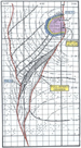 Figure
5. Structural contour map on top of Mississippian “lime” of the Garber
area, north-central Oklahoma, showing a pop-up block and an associated
graben.
Figure
5. Structural contour map on top of Mississippian “lime” of the Garber
area, north-central Oklahoma, showing a pop-up block and an associated
graben. Figure
6. Interpreted west-east geo-seismic cross-section across the Garber
structure. Most of the strike-slip movement is thought to have caused
the early reverse separation. Subsequent normal displacement resulted in
formation of the present trap.
Figure
6. Interpreted west-east geo-seismic cross-section across the Garber
structure. Most of the strike-slip movement is thought to have caused
the early reverse separation. Subsequent normal displacement resulted in
formation of the present trap. Figure
7. Structural cross-section across the Garber graben. The interval
Pennsylvanian Hogshooter - top Mississippian “lime” is about 840 feet
thicker in the two fault blocks comprising the graben than in the areas
to the west and to the east.
Figure
7. Structural cross-section across the Garber graben. The interval
Pennsylvanian Hogshooter - top Mississippian “lime” is about 840 feet
thicker in the two fault blocks comprising the graben than in the areas
to the west and to the east. Figure
8. Pre-Pennsylvanian subcrop map of the Oklahoma City uplift (from
Gatewood, 1970). This structure is a highly upthrown, pop-up reverse
fault block bounded on the east by a fault of the Nemaha zone. Maximum
throw is 2400 feet along a very straight, normal-vertical-reverse,
down-to-the-east fault.
Figure
8. Pre-Pennsylvanian subcrop map of the Oklahoma City uplift (from
Gatewood, 1970). This structure is a highly upthrown, pop-up reverse
fault block bounded on the east by a fault of the Nemaha zone. Maximum
throw is 2400 feet along a very straight, normal-vertical-reverse,
down-to-the-east fault. 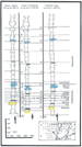 Figure
9. Well-log structural cross-section in the Jennings, Oklahoma, area,
along the en echelon Whitetail fault trend
Figure
9. Well-log structural cross-section in the Jennings, Oklahoma, area,
along the en echelon Whitetail fault trend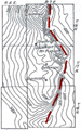 Figure
10. Structural contour map, on top of pre-Pennsylvanian strata, at
Cushing field, south of the Jennings feature and on the same Whitetail
strike-slip fault trend (modified from Weirich, 1929). It is a high
relief, pop-up structure with essentially the same history as the
Oklahoma City, Garber, and El Dorado structures, and with Middle
Pennsylvanian strata overlying deeply
Figure
10. Structural contour map, on top of pre-Pennsylvanian strata, at
Cushing field, south of the Jennings feature and on the same Whitetail
strike-slip fault trend (modified from Weirich, 1929). It is a high
relief, pop-up structure with essentially the same history as the
Oklahoma City, Garber, and El Dorado structures, and with Middle
Pennsylvanian strata overlying deeply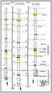 Figure
11. Structural cross-section of graben in the Wetumka area, east-central
Oklahoma, located southeast and basinward of Jennings and Cushing; it is
on an en echelon fault trend east of the Whitetail trend. Desmoinesian
strata in the graben are thicker than on the flanks due to syntectonic
deposition. Vertical exaggeration required to illustrate detail.
Figure
11. Structural cross-section of graben in the Wetumka area, east-central
Oklahoma, located southeast and basinward of Jennings and Cushing; it is
on an en echelon fault trend east of the Whitetail trend. Desmoinesian
strata in the graben are thicker than on the flanks due to syntectonic
deposition. Vertical exaggeration required to illustrate detail. 