The Role of Visuospatial Ability in Developing Mental Models during Geologic Mapping
H. L. Petcovic¹, K. M. Baker¹, C. N. Callahan¹, D. Z. Hambrick², J. C. Libarkin², J. Elkins³,
S. P. Turner², T. A. Rench², and N. LaDue²
¹Western Michigan University, Kalamazoo, MI, USA
²Michigan State University, East Lansing, MI, USA
³University of Northern Colorado, Greeley, CO, USA
Abstract
Geologic mapping draws heavily on 3D visualization, as the geologist must navigate through unfamiliar terrain, observing and interpreting scattered surface rock outcrops to create an accurate mental representation of the 3D subsurface geology. The geologist must then transfer a 3D mental representation onto a 2D geologic map. Geological knowledge is critical to success in this type of mapping; without, for example, correct identification of lithologies or correct interpretation of structural or stratigraphic features, the geologist cannot produce an accurate map. Presumably, visuospatial ability also plays a key role in geologic mapping. Not only does the geologist have to negotiate between the map and the physical field environment, but he or she must imagine how isolated surface rock outcrops relate to one another at depth.
As part of a larger study, we investigated how cognitive factors such as domain content knowledge, visuospatial ability, perceptual ability, working memory capacity, and problem-solving ability manifest and vary across a sample of field geologists with differing levels of expertise. Cognitive factors were assessed through a suite of paper-pencil and computer-based tasks; problem-solving ability was assessed through a bedrock geologic mapping task in which participant movement was tracked via GPS. For the purpose of this conference presentation, we focus on the observed relationships between visuospatial ability, domain content knowledge, navigation in the field, and success in the mapping task among novices and experts in order to address the general question: what role does visuospatial ability play in successful geologic mapping?
Sixty-seven geologists (54% male, mean age = 36.4 years, 21% current undergraduate student, 28% current graduate student, 55% with professional work experience), completed the suite of cognitive tasks and the 1-day mapping project in the Rocky Mountains, Montana, USA. The map area was 70 hectares in size and included four distinct lithologies: three Paleozoic sedimentary units form a plunging syncline, one limb of which is cut by a thrust fault that has uplifted Precambrian metamorphic bedrock. Expertise was determined through scoring of experiential variables such as prior coursework, degrees, and work experience in both geology (DEQ-G) and geologic mapping (DEQ-Gm). Visuospatial ability was assessed by means of: three tests of visuospatial reasoning - paper folding (Ekstrom et al., 1976), form boards (Ekstrom et al., 1976), and space relations (Bennett et al. 1972); two tests of visuospatial working memory capacity - matrix span and arrow span (Hambrick & Oswald, 2005); and one test of perceptual speed - pattern comparison (Salthouse & Babcock, 1991). Geologic content knowledge was assessed by a modified version of the Geoscience Concept Inventory (GCI; Libarkin and Anderson, 2005). Spatial patterns during navigation were determined by GIS analysis of GPS tracks, factor analysis of general track characteristics, and sequence alignment methods (Baker et al., 2012). Success at the mapping task was determined by two metrics: accuracy of the rock distribution (determined by GIS comparison of a participant map to a consensus map of the area), and accuracy of the structural interpretation of the map area (determined by scoring the correctness of the plunging syncline and thrust fault as shown on each participant's paper map)
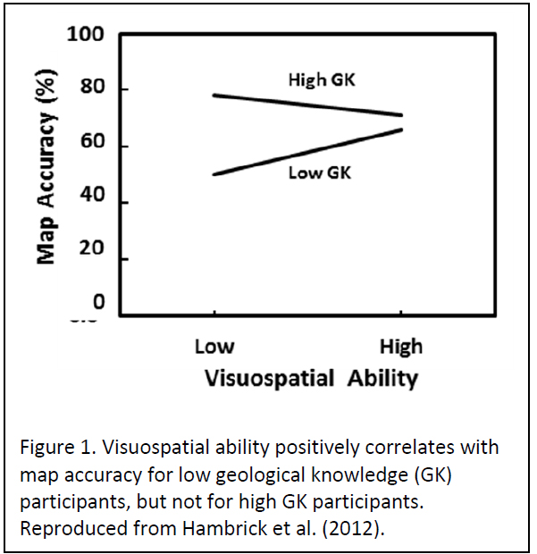
Previous work by our group has demonstrated two key findings. First, Hambrick et al. (2012) examined the relationship between visuospatial ability, geological content knowledge, and success in the mapping task. A hierarchical regression analysis found a significant visuospatial ability by geological knowledge interaction, in the direction of a positive effect of visuospatial ability on map accuracy at low, but not high, levels of geological knowledge (Figure 1). We interpret this finding to indicate that visuospatial ability "matters" in successful mapping for novices (who have low geological knowledge) but not for experts.
Secondly, principal component analysis of the GPS track data (Baker et al., 2012) demonstrated that track variables loaded onto two components: thoroughness and speed. For all participants, success at the mapping task (both in accuracy of the rock distribution and correct interpretation of the structures) correlated with both geological knowledge and thoroughness (p<.05). For participants with prior mapping experience, however, correct structural interpretation correlated with speed (p<.05), such that fast mappers also produced accurate interpretations of the geologic structures. We interpret these findings to suggest that experienced mappers form mental models of the underlying structure that enable them to rapidly complete the mapping task.
During a more recent analysis of the post-mapping interviews we found that many participants could describe in words and gestures a significantly more accurate understanding of the underlying geologic structures than was shown in their paper maps. Participants' mental models of the geology in the map area were then assessed by analyzing multiple sources of data (paper maps, interviews, field notes, and draft maps) in order to robustly characterize and score each geologists' understanding of the underlying geology. Thus we have identified a new variable that may play a critical role in mapping that we term mental model accuracy. The new analyses as described below address both gaps in our previous work and questions about the role of visuospatial ability in developing mental models of geologic structures while mapping.
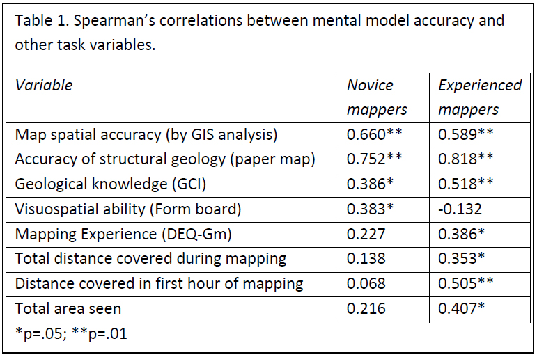
For analysis purposes, participants were grouped into novices (N=37) and those with prior mapping experience (N=30) based on a natural break in the mapping experience (DEQ-Gm) data. Spearman's rho was used for all correlations involving model accuracy, since expertise is a non-parametric variable. As shown in Table 1, mental model accuracy correlated with other measures of map quality (map spatial accuracy and map structural interpretation) for all participants. Mental model accuracy also correlated with geologic knowledge for both groups. Only one correlation between mental model accuracy and visuospatial ability (form board test) was found, and this only for the novice population. Mental model accuracy correlated with mapping expertise and several field movement variables (total distance in the field, distance covered in the first hour of the mapping task, and total area seen while in the field area) for experienced participants only.
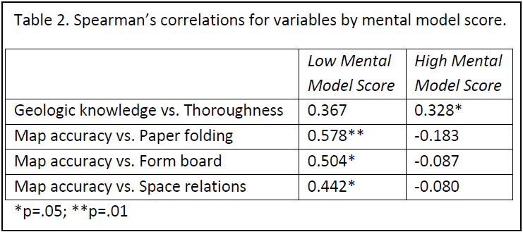
To further investigate the relationship between visuospatial ability and other variables with mental model accuracy, we split the participants into two groups based on a natural break in the data at a 50% score: those with high accuracy ('High Mental Model') mental models of the geology in the field area (N=44) and those with low accuracy mental models ('Low Mental Model')(N=22). As shown in Table 2, we found a correlation between geologic knowledge and thoroughness only for the group of participants with high mental model scores. Within this group of participants, a good understanding of geology correlated with thoroughness in the field. Interestingly, we found correlations between all three visuospatial variables and accuracy of the rock distribution on the map ('Map Accuracy') only within the group of participants who had low mental model scores (i.e. those with inaccurate (or absent) mental models of the field area). For this group, it appears that visuospatial ability plays a role in developing an accurate representation of the distribution of rocks, but not in developing an accurate mental model of the underlying geology. These results are strikingly similar to the Hambrick et al. (2012) study which found no correlations between visuospatial ability and structural interpretation of the map area; significant results pertain only to the accuracy of bedrock distribution on the paper map.
Together, these preliminary data suggest that visuospatial ability may be less important in geologic mapping than previously assumed. We found no correlations between visuospatial ability and mental model accuracy among experienced mappers. For inexperience mappers, we found only one correlation between visuospatial ability (on one of three tests) and quality of mental model developed. Furthermore, the results suggest that visuospatial ability does play a role in developing accurate representations of the spatial distribution of rocks in a field area, but not in developing models of the 3D structural geology. Instead, geologic knowledge appears to play a much more critical role in developing accurate interpretations of 3D geology during mapping.
This work is supported by the National Science Foundation under Grants No. DRL-0815930 and DRL-0815764. Any opinions, findings, and conclusions or recommendations expressed here are those of the authors and do not necessarily reflect the views of the National Science Foundation.
REFERENCES
Baker, K. M., Petcovic, H. L., Wisniewska, M., & Libarkin, J. C. (2012). Spatial signatures of mapping expertise among field geologists. Cartography and Geographic Information Science 39(3), 119-132. DOI 10.1559/15230406393119
Bennett, G.K., Seashore, H.G., & Wesman, A.G. (1972). Manual of Differential Aptitude Test. New York: The Psychological Corporation.
Ekstrom, R. B., French, J. W., Harman, H. H., & Derman, D.(1976). Manual of the Kit of Factor-Referenced Cognitive Tests. Princeton, NJ: Educational Testing Service.
Hambrick, D. Z., Libarkin, J. C., Petcovic, H. L., Baker, K. M., Elkins, J., Callahan, C. N., Turner, S. P., Rench, T. A., & LaDue, N. D. (2012). A test of the Circumvention-of-Limits hypothesis in scientific problem solving: The case of geological bedrock mapping. Journal of Experimental Psychology: General, 141(3), 397-403. DOI 10.1037/a0025927
Hambrick, D. Z., & Oswald, F. L. (2005). Does domain knowledge moderate involvement of working memory capacity in higher-level cognition? A test of three models. Journal of Memory and Language, 52, 377-397.
Libarkin, J.C., & Anderson, S.W. (2005). Assessment of learning in entry-level geoscience courses: Results from the Geoscience Concept Inventory. Journal of Geoscience Education, 53, 394-401.
Salthouse, T. A., & Babcock, R. (1991). Decomposing adult age differences in working memory. Developmental Psychology, 27, 763-776.
AAPG Search and Discovery Article #120140© 2014 AAPG Hedberg Conference 3D Structural Geologic Interpretation: Earth, Mind and Machine, June 23-27, 2013, Reno, Nevada