Improving Spatial Reasoning Skills in the Undergraduate Geoscience Classroom Through Interventions Based on Cognitive Science Research
Carol J. Ormand1,3, Thomas F. Shipley2, Basil Tikoff3, Cathryn Manduca1, Barbara Dutrow4, Laurel Goodwin3, Thomas Hickson5, Kinnari Atit2, Kristin Gagnier2, and Ilyse Resnick2
1Science Education Resource Center, Carleton College, Northfield, MN, USA
2Department of Psychology, Temple University, Philadelphia, PA, USA
3Department of Geoscience, University of Wisconsin, Madison, WI, USA
4Department of Geology & Geophysics, Louisiana State University, Baton Rouge, LA, USA
5Department of Geology, University of St. Thomas, St. Paul, MN, USA
Abstract
Spatial visualization is an essential prerequisite for understanding and solving many geological problems, such as interpreting the 3D structure of a complex fault system, visualizing the 3D architecture of sedimentary deposits, and visualizing the atomic structure of minerals that comprise the Earth. Undergraduate geoscience students, in both introductory and upper-level courses, bring a wide range of spatial skill levels to the classroom. Moreover, spatial thinking is multi-faceted. It is not unusual for individual students to excel at some spatial skills while struggling with others. However, spatial thinking improves with practice, and can improve more rapidly with intentional training. As a group of geoscience faculty members and cognitive psychologists, we are collaborating to apply the results of cognitive science research to the development of teaching materials to improve undergraduate geology majors' spatial thinking skills.
Beginning in the fall of 2011, we have been administering a series of tests of spatial thinking skills to students in Structural Geology, Sedimentology and Stratigraphy, and Mineralogy courses at three different institutions (the University of Wisconsin-Madison, the University of St. Thomas, and Louisiana State University, respectively). In an attempt to measure aspects of spatial thinking that we expect to be important in these courses, we have selected a number of spatial thinking tests to include in our study. One of these is a mental rotation test (identifying which objects are the same, in different orientations), three are tests of mental slicing (choosing the correct image of a slice through an object), and one is a "water level" test (marking a horizontal line within a tilted frame of reference) (see Figure 1). By giving these tests at both the beginning and the end of each semester, we are able to measure the range of spatial skills in each classroom and the degree to which these skills improve over the course of the semester.
Pre-test scores indicate that students arrive in the undergraduate geoscience classroom with a wide range of spatial thinking skills. While some students are adept at one or more of these tasks, others struggle with some or all of them. Most are somewhere in the middle on most of the tests (see Figure 2). Furthermore, while these test scores are statistically correlated, many students who are adept at some of the spatial tests struggle with others. For example, the same student may score more than a standard deviation above the class average on the mental rotation test and more than a standard deviation below the class average on the geologic block slicing test. Pre- and post-test comparisons show that students' spatial skill levels typically improve over the course of an academic term, suggesting that simply grappling with geoscience concepts helps students to think spatially. However, average gains are quite modest (on the order of 10% average improvement; see Figure 2). The goal of our project is to see whether we can improve these gains in spatial thinking skills through the use of teaching materials specifically designed to do so.
Two promising teaching strategies have emerged from recent cognitive science research into spatial thinking: gesture and progressive alignment. Gesture is familiar to most geoscientists as a means of communication, particularly for spatial information, but is less likely to be consciously employed as a teaching strategy. Nonetheless, recent studies have shown that using gesture can facilitate student learning, and that students who gesture learn better than those who just watch their instructors gesture (but do not, themselves, use gestures) (e.g., Goldin-Meadow, 2011). Cognitive scientists propose that this is because gesture provides a mechanism for cognitive offloading: that is, it allows the "thinker" to do some of their mental work with their hands, thus freeing neural pathways in the brain to perform other cognitive functions.
Progressive alignment is a strategy for helping students to build on their understanding of simple, familiar spatial concepts to understand more complex, less familiar spatial concepts. Alignment is simply a comparison of two objects that share some characteristics. For example, one could align an upright, open, parallel, rounded fold with an upright, open, parallel chevron fold by noting that both are upright, open and parallel, but one has a rounded hinge and one is angular. Progressive alignment involves moving from a comparison of very similar objects, such as the folds just described, toward a comparison of more dissimilar objects – e.g., two folds with very dissimilar geometry. This process – moving from comparison of similar objects to comparison of dissimilar objects – facilitates the students' ability to make visual comparisons and visual analyses (e.g., Gentner and Markman, 1994).
We are using these two concepts to develop new teaching materials for Mineralogy, Structural Geology, and Sedimentology & Stratigraphy courses for undergraduates. The faculty members teaching each of our courses have identified spatial concepts or tasks that are challenging for many of their students. For each of these challenges, we are working in interdisciplinary teams (geoscience educators and cognitive scientists) to construct gesture exercises, progressive alignment exercises, or both.
For the purposes of this study, the data we collected during the 2011-2012 academic year are our baseline data for each course at each institution. Starting in the fall of 2012, we have been implementing our gesture and progressive alignment exercises in each of the courses. By May of 2013, we will have comparison data for courses in Structural Geology and Mineralogy. These data will allow us to determine whether the research-based teaching materials we are developing boost students' spatial thinking skills, beyond the gains we would expect them to show simply from taking the courses.
References cited:
Gentner, D., and Markman, A.B. (1994). Structural alignment in comparison: No difference without similarity. Psychological Science, v. 5, pp. 152-158.
Goldin-Meadow, S. (2011). Learning through gesture. WIREs (Wiley Interdisciplinary Reviews): Cognitive Science, v. 2, n. 6, pp. 595-607.
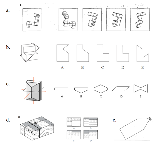
Figure 1: Example questions from each of the spatial skills tests we are using. a. Mental rotation test. Instructions: mark the two objects that are the same as the one on the left. b-d. Mental slicing tests. Instructions: choose the figure that shows what you would see on the slicing plane. e. Water level test. Instructions: assuming that the bottle is half full of water, draw a line to show the top of the water surface.
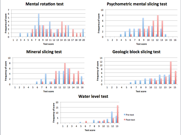
Figure 2: Pre- and post-test score distributions from the UW-Madison Structural Geology class, spring 2012. For each graph, the x-axis is the score on the test and the y-axis is the number of students receiving that score. Pre-test scores are shown in blue, and post-test scores are red.
AAPG Search and Discovery Article #120140© 2014 AAPG Hedberg Conference 3D Structural Geologic Interpretation: Earth, Mind and Machine, June 23-27, 2013, Reno, Nevada