Complex Stratigraphy and Sedimentology of an Inner Shelf Shoal
and Nearshore along the Northeastern Gulf of Mexico, USA
Amy L. Spaziani1,2, Gregory W. Stone1,2, and Baozhu Liu2
1Department of Oceanography and Coastal Sciences, Louisiana State University,
218A Howe-Russell Geoscience Complex, Baton Rouge, Louisiana 70803
2Coastal Studies Institute, Louisiana State University,
216 Howe-Russell Geoscience Complex, Baton Rouge, Louisiana 70803
EXTENDED ABSTRACT
The inner shelf and nearshore region of the northeast Gulf of Mexico (GOM) has been well documented as a massive sheet sand known as the Mississippi-Alabama-Florida (MAFLA) sand sheet (Doyle and Sparks, 1980). This transgressive deposit is believed to be homogeneous throughout the region, is a result of re-worked sediment during the latest transgression (Ludwick, 1964), and is economically important in terms of borrow sources for beach/barrier island restoration projects. While many studies of sediment stratigraphy, sedimentology, and lithology offshore exist around the Apalachicola region and from Pensacola west to Louisiana, few papers have documented the sediments and stratigraphy offshore the central Florida Panhandle. Hyne and Goodell (1967) interpreted shallow stratigraphy (the uppermost portion of the MAFLA unit) of two inner shelf shoals off Choctawhatchee Bay, Florida (Figure 1). However, the relationship of the MAFLA deposit to earlier, late Quaternary deposits is of interest, in particular to beach restoration projects. In addition, the decreased rate of sea level rise (approximately the last 3000 yr) due to tectonic stability of the region has fostered an interest in the effects of modern hydrodynamics on the MAFLA and other late Quaternary deposits offshore. Therefore, the objectives of this study are to (1) delineate the sedimentary units and lateral facies relationships of the inner shelf and nearshore, (2) interpret the geologic history and depositional environments during the late Quaternary, and (3) to evaluate the modern seafloor topography and sedimentology, due to effects of sea level and modern hydrodynamics. It is proposed that the stratigraphy and sedimentology of this region is a product of transgressive processes during the last sea level rise and modern hydrodynamics, particularly those during storms.
This study utilizes approximately 1100 km (~684 mi) of sub-bottom seismic profiles along the inner shelf shoal and nearshore. The seismic profiles are high resolution CHIRP and ORE Geopulse “boomer” profiles. In addition, 257 vibracores were collected on separate cruises from the shoal and nearshore. The cores are approximately 5-6 m (~16-20 ft) in length and were split longitudinally, logged and photographed. Bathymetry was obtained during all cruises (seismic and coring) and integrated with bathymetry from the National Geophysical Data Center. The cores were sampled at 46 cm (1.5 ft) intervals for granulometric analysis. Granulometry was performed by dry sieving using the GilSonic AutoSiever GA-6 Model. Granulometry was calculated according to Folk and Ward (1957). Percent carbonate was determined by acid digestion of selected samples. Sixty samples of wood and peat material were extracted at different locations from 45 different cores. Five samples of in situ peat material from two different cores were radiometrically dated.
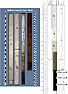
Preliminary results indicate that the region is characterized by three major units (two reflectors) in seismic profiles and by six sub-units delineated in core stratigraphy five of which can be seen in Figure 2. The bottommost unit, unit 1a, of the core is characterized by an oxidized and dark brown, silty clay deposit often heavily bedded with peat and wood. Samples from this unit yield results of ages of 25,290 radiocarbon yrs BP and older. The top of unit 1 is in good agreement with a fairly prominent reflector in seismic profiles. Unit 1 is overlain by poorly to a moderately sorted unit of clayey silt and sand, characterized by burrowing, wood and peat, and shell material. Unit 2 grades upward into a muddy sand (unit 3), with mud filled burrows, and occasionally thin layers of silt and sand, and grades into unit 4, a lighter colored, better sorted, although slightly finer sand with abundant shell. Unit 4 is overlain by the topmost unit, 5, a white, well sorted, medium to coarse, quartz sand with some shells, and is at least 0.5 to 2.0 m (~1.6-6.6 ft) in cores, representing the largest unit sampled by thickness. In many cores, especially the eastern nearshore cores, a massive unit of carbonate cemented sediments (unit 1b) replaces unit 1a, and sometimes unit 2, at the base of the core.
A preliminary investigation of the cores indicates that the bottommost unit is of Pleistocene age, from the characteristics of the deposit and radiocarbon ages of in situ peat material. This material is indicative of subaerial exposure during the last major lowstand in sea level. Units 2 and 3 indicate lagoon or bay environments deposited during the initial rise in sea level, post-lowstand. Unit 4 is interpreted as a beach deposit, and Unit 5 is interpreted as the MAFLA sand sheet, both deposited during the last rapid rise in sea level. These units are in good agreement with the findings of McBride (1997), and McBride et al. (1999, 2004) in the sub-bottom stratigraphy of the inner shelf offshore of Pensacola, Perdido, and Mobile bays (western Florida and Alabama). Ongoing investigations continue focusing on the sedimentology and the integration of seismic, core, and granulometric data, with the goal of interpreting the geologic history of the late Quaternary and formation of the inner shelf and nearshore stratigraphy.
REFERENCES CITED
Doyle, L. J., and T. N. Sparks, 1980, Sediments of the Mississippi, Alabama, and Florida (MAFLA) continental shelf: Journal of Sedimentary Petrology, v. 50, p. 915-905.
Folk, R. L., and W. C. Ward, 1957, Brazos River bar [Texas]; a study in the significance of grain size parameters: Journal of Sedimentary Petrology, v. 27, p. 3-26.
Hyne, N. J., and H. G. Goodell, 1967, Origin of the sediments and submarine geomorphology of the inner continental shelf off Choctawhatchee Bay, Florida: Marine Geology, v. 5, p. 299-313.
Ludwick, J. C., 1964, Sediments in northeastern Gulf of Mexico, in R. L. Miller, ed., Papers in marine geology: Macmillan Co., New York, p. 204-238.
McBride, R. A., 1997, Seafloor morphology, geologic framework, and sedimentary processes of a sand-rich shelf offshore Alabama and northwest Florida: Northeastern Gulf of Mexico: Louisiana State University, Baton Rouge, 509 p.
McBride, R. A., L. C. Anderson, A. Tudoran, and H. H. Roberts, 1999, Holocene stratigraphic architecture of a sand-rich shelf and the origin of linear shoals: Northeastern Gulf of Mexico, in K. M. Bergman, ed., Isolated shallow marine sand bodies; sequence stratigraphic analysis and sedimentologic interpretation: Society of Economic Paleontologists and Mineralogists Special Publication 64, Tulsa, Oklahoma, p. 95-126.
McBride, R. A., T. F. Moslow, H. H. Roberts, and R. J. Diecchio, 2004, Late Quaternary geology of the northeastern Gulf of Mexico shelf; sedimentology, depositional history, and ancient analogs of a major shelf sand sheet of the modern transgressive systems tract, in J. B. Anderson, and R. H. Fillon, eds., Late Quaternary stratigraphic evolution of the northern Gulf of Mexico margin: Society for Sedimentary Geology Special Publication 79, Tulsa, Oklahoma, p. 55.
Spaziani, A. L., G. W. Stone, and B. Liu, 2009, Complex stratigraphy and sedimentology of an inner shelf shoal and nearshore along the northeastern Gulf of Mexico, USA: Gulf Coast Association of Geological Societies Transactions, v. 59, p. 719-722.
| Figure 1. Complex bathymetry of the study area in the northeastern GOM. 1 m = ~3.28 ft, and 1 km = ~0.62 mi. | |
 |
AAPG Search and Discover Article #90093 © 2009 GCAGS 59th Annual Meeting, Shreveport, Louisiana