Multicomponent 4-D Seismic Reservoir Characterization of Tight Gas Sands,
Rulison Field, Colorado
Thomas L. Davis*, Department of Geophysics, Colorado School of Mines, Golden, CO 80401 [email protected]
Summary
The Colorado School of Mines Reservoir Characterization Project (RCP) is conducting time-lapse multicomponent seismic surveys at Rulison field, Piceance basin, Colorado, to identify and monitor fracture zones in tight gas sands. Multicomponent seismic monitoring is being conducted in a tight gas development project for the first time, as drilling to 10-acre well spacing is occurring. The purpose of the study is to use dynamic reservoir characterization to develop reservoir-characterization technologies and improve recovery efficiency in tight gas reservoirs.
Introduction
Rulison field is a basin-centered gas accumulation with a long production history dating back to the 1960s. In the study area, 25 wells have been drilled before 1996, with approximately 50 wells drilled between 1996 and 2003, when new completion techniques and an increase in gas prices made this resource more economic. The reservoir is made up of fluvial deltaic sandstones and coals in the lower part of the Williams Fork Formation and alluvial-plain sandstones in the upper part.
Natural fractures significantly enhance the relative permeability to gas. Permeability enhancement through hydraulic fracturing is greatest when the hydraulic fracture stimulation connects the natural fracture network to the well bore. Three multicomponent (9-C) seismic surveys were acquired in Rulison field (fig. 1).
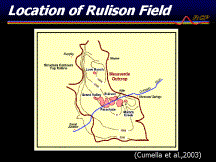
Figure 1. Rulison field, Piceance basin, Colorado.
Rulison field produces out of Cretaceous Mesaverde tight gas sandstones (fig. 2). The pay section spans a 1,200-feet-thick interval that is overpressured. The reservoirs consist of multiple-stacked lenticular sandstone bodies with matrix permeabilities ranging from 5 to 80 microdarcies. Williams Production Company, operator, is conducting an infill drilling program to reduce well spacing to 10 acres.
Conventional p-wave seismic data have done little to augment this play. Multicomponent seismic data were shot by RCP to determine if it would detect fracture zones that control the permeability structure in the reservoir. Most wells are completed in multiple zones starting 300 feet below the UMV shale and extending into the Cameo interval.
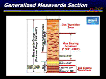
Figure 2. Tight gas sands in the Mesaverde Group.
Seismic Acquisition
Seismic data were acquired using the Vectorseis radio telemetry system in 2003 and the cable telemetry system in 2004 and 2006. P- and S-wave vibrators were used to acquire a full wave field (9-C) survey. Subsurface bin size is 55 « 55 feet with 1,500 single Vectorseis sensor locations and 770 source locations with three components of source located at each source point. The grid was located as a single live patch throughout the survey with the receiver line spacing of 330 feet and source line spacing of 660 feet (fig. 3).
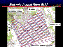
Figure 3. Acquisition grid.
Fracture Detection
A comparison of p- and s-wave data is shown in fig. 4. Note the seismic character in the reservoir interval from the UMV to Cameo is different between p- and s-waves. This difference is due to the different impedance that is affecting the seismic response of these two wave modes. Shear waves are affected by rigidity, whereas p-waves are affected by compressibility and rigidity. P-waves are sensitive to the presence of gas, which affects bulk compressibility. Shear waves are unaffected by gas and are better for imaging this gas reservoir. Another significant factor is fractures. Shear waves are much more sensitive to fractures than p-waves. Changes in reflectivity of shear waves can be attributed to changes in rigidity caused by fractures. Notice the area in the middle part of the line in the UMV to Cameo interval where the reflectivity changes. The change is due to fractures in the middle part of the interval. Notice, also, the difference in character in the Cameo to R2 interval between the p- and s-wave data. The high reflectivity of the p-wave is due to high-pressure gas in this interval, whereas the shear-wave data do not respond to gas. In summary, the multicomponent data give different images of the reservoir, and these images are of value for fault and fracture delineation and for detecting gas-saturated intervals.
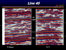
Figure 4. Comparison of p- and s-wave data.
There is overpressure in Rulison field due to gas generation. Depletion of pressure above the coals in the reservoir interval has the potential to create remigration of gas from the coals into the overlying reservoir interval. Remigration through the fracture network is a possible explanation for abnormally high productivity wells that are connected through the fracture system (Davis et al, 2005). Time-lapse difference mapping of the Cameo coal interval between the 1996 and 2003 survey supports the hypothesis of remigration (fig. 5).
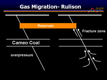
Figure 5. Gas remigration through the fault and fracture network (from Davis et al, 2005).
The zone of gas remigration is potentially through fault and fracture systems as illustrated in fig. 5 and faults. Wrench faults are conduits for this remigration and a wrench-fault system is imaged better with shear-wave data than p-wave data as shown in fig. 6.
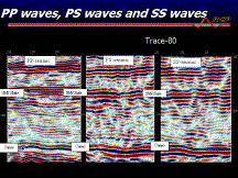
Figure 6. Seismic data illustrate a wrench fault at Rulison field. The shear-wave data image the fault system better than the p-wave data.
The wrench-fault system running through the middle of the survey is shown on the pure shear-wave data more clearly than on the p- or converted wave data. Breaks associated with these faults are related to rigidity differences associated with shear or brecciated zones. These zones are imaged on borehole image logs. Gas migration up these fault and fracture systems distorts the image on p- and converted wave data, but gas has no effect on the shear-wave data. Not all faults appear to show this phenomena indicating the value of multicomponent data to identify sealing and non-sealing faults. For example, p-wave data show the fault on the southwestern side of the study area clearly as shown on fig. 7.

Figure 7. P-wave fault imaging is variable and potentially dependent on the faults being sealing or non-sealing.
P-wave time-lapse seismic data show the faults in the Cameo coal interval that are exhibiting time-lapse changes associated with production response (see fig. 8). The changes indicate the dynamic response of these faults. The central area is masked by gas, and this is an area of gas remigration. The areas where the faults image well may be due to fracture closure over time as the stress is lowered through production in these intervals. The interval shown is dominated by interbedded coals, sandstones, and shales and is stress sensitive. The interval is also overpressured and as pressures are lowered through completion and production in this interval, the fault and fracture systems are prone to closure. This response can only be seen through time-lapse seismology.
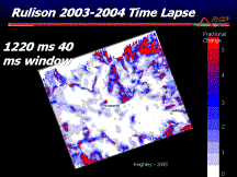
Figure 8. P-wave percentage amplitude difference shows the dynamic response of faults and fracture zones at Rulison field.
Two multicomponent measurements are important for tight gas sands exploration. These include Vp/Vs and anisotropy mapping. Rojas (2005) indicated that low Vp/Vs is an indication of gas saturation (see fig. 9). Figure 10 shows an area of high gas saturation in the tight gas sand interval within the wrench-fault zone as indicated by Rojas (2005). Vp/Vs is a potential tool for both exploration and production of tight gas sands. The second measurement is seismic shear-wave azimuthal anisotropy. Figure 11 shows an anisotropy map derived from amplitude analysis of the pure shear-wave data from the upper Williams Fork by Jansen (2005). The area of high anisotropy corresponds to an area of high fracture density.
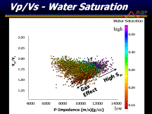
Figure 9. Vp/Vs ratio mapping assists in characterizing highly gas-saturated reservoirs (Rojas, 2005).
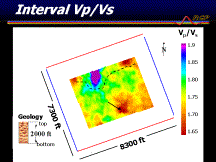
Figure 10. Vp/Vs mapping of the Williams Fork reservoir from UMV to Cameo (Rojas, 2005).
A Òsweet spotÓ is a zone of natural fracturing that is connected to the Cameo source beds. An exploration and production strategy is to find the faults using multicomponent seismology and then high grade the better reservoir through a combination of Vp/Vs measurements and shear-wave azimuthal anisotropy. A development strategy is to monitor the reservoir during the early phases of development with time-lapse multicomponent seismology to accelerate production from the better quality reservoir first. Predicting natural fracture swarms and high production sweet spots is critical to the economics of unconventional gas plays.
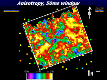
Figure 11. Shear-wave azimuthal anisotropy map with estimated ultimate recovery overlay. The highest EUR wells are colored in red and orange (from Jansen 2005).
Conclusions
High productivity zones, or Òsweet spots,Ó are those zones with the greatest storage capacity, the highest fracture density, and are connected through the fault and fracture systems as containers for remigrated gas from the source beds. Multicomponent 4D-seismic data show these Òsweet spotsÓ as areas of low Vp/Vs and high anisotropy related to high fracture density.
References
Cumella, S. and Ostby, D. B., 2003, Geology of the basin-centered gas accumulation: Rocky Mountain Association of Geologists, Piceance Basin Guidebook, p.171Ð193.
Davis, T. L., Benson, R. D., Ansorger, C., and Kendall, R., 2005, Time-lapse seismic study for tight gas sands, Rulison field, Colorado: Nafta, v. 56, no. 11, p. 407Ð410.
Jansen, K., 2005, Seismic investigation of wrench faulting and fracturing at Rulison field, Colorado: Colorado School of Mines, M.S. thesis # T-6034, 121 p.
Rojas, E. 2005, Elastic rock properties of tight gas sandstones for reservoir characterization at Rulison field, Colorado: Colorado School of Mines, M.S. thesis # T-6077, 194 p.
Acknowledgments
Thanks are extended to sponsors of the Reservoir Characterization Project who supported this work.
AAPG Search and Discover Article #90067©2007 AAPG Mid-Continent Section Meeting, Wichita, Kansas