![]() Click to view article in PDF format
(~5.7 mb).
Click to view article in PDF format
(~5.7 mb).
 Click to view presentation (80 slides),
preceded by abstract, in PDF format (~13.5 mb).
Click to view presentation (80 slides),
preceded by abstract, in PDF format (~13.5 mb).
Received Shelton Award for best paper presented in Search and Discovery 2009.
The Evolving Exploration of the Subsalt Play in the Offshore Gulf of Mexico*
Dwight "Clint" Moore1 and Robert O. Brooks2
Search and Discovery Article #60021 (2009)
Posted March 28, 2009
*Adapted from presentation at GCAGS Convention, 1995, and accompanying article in GCAGS Transactions, v. 45, p. 7-12.
Authors’ note: Metric measurements were not utilized because all of the depth data is referenced from well log surveys that utilize English measurements.
1Anadarko Petroleum Corporation, Houston, Texas; current address: ION Geophysical Corporation ([email protected])
2TGS-Calibre Geophysical Company, Houston, Texas
Abstract
The co-existence of horizontal components of ![]() salt
salt![]() movement with subsalt traps in the south additions of the Louisiana and Texas
shelf and slope has been recognized within the last decade (Brooks and Moore,
1993). Throughout the 1970's and 1980's hundreds of wells were drilled into
movement with subsalt traps in the south additions of the Louisiana and Texas
shelf and slope has been recognized within the last decade (Brooks and Moore,
1993). Throughout the 1970's and 1980's hundreds of wells were drilled into ![]() salt
salt![]() on the outer shelf and slope of the northwestern Gulf of Mexico. These wells
barely penetrated
on the outer shelf and slope of the northwestern Gulf of Mexico. These wells
barely penetrated ![]() salt
salt![]() features that are now known to be laterally emplaced
horizontal
features that are now known to be laterally emplaced
horizontal ![]() salt
salt![]() sheets. Drilling was typically stopped thousands of feet short
of testing the potential sizable petroleum reservoirs of the subsalt exploration
play, which is now being pursued and developed. It is apparent that the
evolutionary vertical remobilization of portions of these sheets has structured
many of the supra-
sheets. Drilling was typically stopped thousands of feet short
of testing the potential sizable petroleum reservoirs of the subsalt exploration
play, which is now being pursued and developed. It is apparent that the
evolutionary vertical remobilization of portions of these sheets has structured
many of the supra-![]() salt
salt![]() giant fields discovered in younger, overlying sediments
(Brooks and Denman, 1995; Brooks and Hall, 1995).
giant fields discovered in younger, overlying sediments
(Brooks and Denman, 1995; Brooks and Hall, 1995).
Horizontal emplacement of Gulf of Mexico ![]() salt
salt![]() sheets,
and their effect on subsalt drilling results, can be demonstrated using 2-D time
seismic sections, well logs, and biostratigraphy from over 30 wells drilled
through varying thicknesses of the
sheets,
and their effect on subsalt drilling results, can be demonstrated using 2-D time
seismic sections, well logs, and biostratigraphy from over 30 wells drilled
through varying thicknesses of the ![]() salt
salt![]() sheets. The presence of thick subsalt
sands, such as those observed in SMI 200, are now also proven. Subsalt petroleum
discoveries, announced in SS 349, ST 260, and MC 211, have confirmed the play
and encourage future exploratory drilling. As advanced acquisition and
processing techniques provide improvements in seismic image resolution, and
subsalt well control refines geologic models and concepts, geoscientific
integration will lead to additional significant discoveries in multiple-style
traps beneath the horizontal-
sheets. The presence of thick subsalt
sands, such as those observed in SMI 200, are now also proven. Subsalt petroleum
discoveries, announced in SS 349, ST 260, and MC 211, have confirmed the play
and encourage future exploratory drilling. As advanced acquisition and
processing techniques provide improvements in seismic image resolution, and
subsalt well control refines geologic models and concepts, geoscientific
integration will lead to additional significant discoveries in multiple-style
traps beneath the horizontal-![]() salt
salt![]() sheets of the offshore Gulf of Mexico.
sheets of the offshore Gulf of Mexico.
The 1990's
should be the "Decade of Discovery" for this significant subsalt petroleum
potential, hidden by these ![]() salt
salt![]() sheets that have obscured subsalt seismic images
for decades.
sheets that have obscured subsalt seismic images
for decades.
|
uAbstractuIntroductionuFigures 1-4uBackgrounduSubsalt explorationuFigures 5-40uFigures 41-43uThe 1980’suThe 1990’suFigures 44-45uMoving the play forwarduCommercial resultuActivity acceleratesuFigure 46uConclusionsuAcknowledgmentsuReferences
uAbstractuIntroductionuFigures 1-4uBackgrounduSubsalt explorationuFigures 5-40uFigures 41-43uThe 1980’suThe 1990’suFigures 44-45uMoving the play forwarduCommercial resultuActivity acceleratesuFigure 46uConclusionsuAcknowledgmentsuReferences
uAbstractuIntroductionuFigures 1-4uBackgrounduSubsalt explorationuFigures 5-40uFigures 41-43uThe 1980’suThe 1990’suFigures 44-45uMoving the play forwarduCommercial resultuActivity acceleratesuFigure 46uConclusionsuAcknowledgmentsuReferences
uAbstractuIntroductionuFigures 1-4uBackgrounduSubsalt explorationuFigures 5-40uFigures 41-43uThe 1980’suThe 1990’suFigures 44-45uMoving the play forwarduCommercial resultuActivity acceleratesuFigure 46uConclusionsuAcknowledgmentsuReferences
uAbstractuIntroductionuFigures 1-4uBackgrounduSubsalt explorationuFigures 5-40uFigures 41-43uThe 1980’suThe 1990’suFigures 44-45uMoving the play forwarduCommercial resultuActivity acceleratesuFigure 46uConclusionsuAcknowledgmentsuReferences
uAbstractuIntroductionuFigures 1-4uBackgrounduSubsalt explorationuFigures 5-40uFigures 41-43uThe 1980’suThe 1990’suFigures 44-45uMoving the play forwarduCommercial resultuActivity acceleratesuFigure 46uConclusionsuAcknowledgmentsuReferences
uAbstractuIntroductionuFigures 1-4uBackgrounduSubsalt explorationuFigures 5-40uFigures 41-43uThe 1980’suThe 1990’suFigures 44-45uMoving the play forwarduCommercial resultuActivity acceleratesuFigure 46uConclusionsuAcknowledgmentsuReferences
uAbstractuIntroductionuFigures 1-4uBackgrounduSubsalt explorationuFigures 5-40uFigures 41-43uThe 1980’suThe 1990’suFigures 44-45uMoving the play forwarduCommercial resultuActivity acceleratesuFigure 46uConclusionsuAcknowledgmentsuReferences
uAbstractuIntroductionuFigures 1-4uBackgrounduSubsalt explorationuFigures 5-40uFigures 41-43uThe 1980’suThe 1990’suFigures 44-45uMoving the play forwarduCommercial resultuActivity acceleratesuFigure 46uConclusionsuAcknowledgmentsuReferences
uAbstractuIntroductionuFigures 1-4uBackgrounduSubsalt explorationuFigures 5-40uFigures 41-43uThe 1980’suThe 1990’suFigures 44-45uMoving the play forwarduCommercial resultuActivity acceleratesuFigure 46uConclusionsuAcknowledgmentsuReferences
uAbstractuIntroductionuFigures 1-4uBackgrounduSubsalt explorationuFigures 5-40uFigures 41-43uThe 1980’suThe 1990’suFigures 44-45uMoving the play forwarduCommercial resultuActivity acceleratesuFigure 46uConclusionsuAcknowledgmentsuReferences
uAbstractuIntroductionuFigures 1-4uBackgrounduSubsalt explorationuFigures 5-40uFigures 41-43uThe 1980’suThe 1990’suFigures 44-45uMoving the play forwarduCommercial resultuActivity acceleratesuFigure 46uConclusionsuAcknowledgmentsuReferences
uAbstractuIntroductionuFigures 1-4uBackgrounduSubsalt explorationuFigures 5-40uFigures 41-43uThe 1980’suThe 1990’suFigures 44-45uMoving the play forwarduCommercial resultuActivity acceleratesuFigure 46uConclusionsuAcknowledgmentsuReferences
uAbstractuIntroductionuFigures 1-4uBackgrounduSubsalt explorationuFigures 5-40uFigures 41-43uThe 1980’suThe 1990’suFigures 44-45uMoving the play forwarduCommercial resultuActivity acceleratesuFigure 46uConclusionsuAcknowledgmentsuReferences
uAbstractuIntroductionuFigures 1-4uBackgrounduSubsalt explorationuFigures 5-40uFigures 41-43uThe 1980’suThe 1990’suFigures 44-45uMoving the play forwarduCommercial resultuActivity acceleratesuFigure 46uConclusionsuAcknowledgmentsuReferences
uAbstractuIntroductionuFigures 1-4uBackgrounduSubsalt explorationuFigures 5-40uFigures 41-43uThe 1980’suThe 1990’suFigures 44-45uMoving the play forwarduCommercial resultuActivity acceleratesuFigure 46uConclusionsuAcknowledgmentsuReferences
uAbstractuIntroductionuFigures 1-4uBackgrounduSubsalt explorationuFigures 5-40uFigures 41-43uThe 1980’suThe 1990’suFigures 44-45uMoving the play forwarduCommercial resultuActivity acceleratesuFigure 46uConclusionsuAcknowledgmentsuReferences
uAbstractuIntroductionuFigures 1-4uBackgrounduSubsalt explorationuFigures 5-40uFigures 41-43uThe 1980’suThe 1990’suFigures 44-45uMoving the play forwarduCommercial resultuActivity acceleratesuFigure 46uConclusionsuAcknowledgmentsuReferences |
This paper discusses the history of the subsalt petroleum exploration play (SPEP) in the northwestern Gulf of Mexico. Before oil was first discovered in the late 1800's, mankind had explored for resources and knowledge in many ways. It took visionary leadership, coupled with technology, intelligence, and funding to drill the first well in rural Pennsylvania, just as it had taken Columbus, Magellan, and Lewis and Clark to discover new worlds. Over fifty years later, these same ingredients came together again to step offshore into the Gulf of Mexico, where the world's offshore petroleum industry was born. Background to the PlayAfter 45 years of petroleum exploration and development in the offshore Gulf of Mexico, over 35,000 wells have been drilled, with over 9 billion barrels of oil and in excess of 100 trillion cubic feet of gas having been discovered and produced (Melancon et al, 1994). Statistical probability theory suggests that such large reserves, having been produced over such a time period, might preclude the discovery of additional giant fields. However, even in a mature United States petroleum basin, such as the offshore Gulf of Mexico (Figures 1, 2, 3, and 4), new oil and gas fields are still being discovered with the application of new technology, which contributes significantly to enhanced economic feasibility and new plays. The SPEP confirms that potential, and its growth evolves from the most recent large commercial play in the Gulf, the Plio-Pleistocene play of the 1970-80's. During the 1970's, the Plio-Pleistocene play in the south additions of offshore Louisiana and southeast Texas was the emerging trend, with over 3 billion barrels of oil reserves and 40 trillion cubic feet of gas reserves discovered, developed, and produced after 1973, nearly 25 years after initial overall basin exploration began (Melancon et al, 1994). As is the case with many new plays, the
geotechnical leads to the subsalt play were hidden in the wells of
this earlier Plio-Pleistocene trend. For many years, explorers had
drilled one to two miles deep looking for oil and gas sands, but in
several hundred wells, they found
Subsalt Exploration Beginning in 1983, and extending through
the 1980's, an average of one well each year was drilled that
penetrated many different Between 1980 and the present (1995), over
30 wells drilled through/or into varying thicknesses of
However, most of the wells drilled since 1993 cannot be detailed in this paper, due to confidentiality of data as a result of their recent operational activity. Additional wells have penetrated the
Significantly, several wells have
penetrated
There are probably many more that exist
but are not mentioned herein, primarily because the interpretation
of a
The Decade of the 1980's Beginning in September of 1980, the
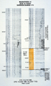
Peltex #1 Mermentau Mineral Land Co. in Cameron Parish, onshore
Louisiana (Figures 5 and
6), was plugged as a 21,500 ft test
well that drilled through 85 feet of The existence of the The first Gulf Oil prospect to be drilled
was a subsalt weld test adjacent to a large regional Spudding within days of the first Gulf
Oil test in fall of 1983, Ship Shoal 366 Placid #2 was permitted as
a 13,000 ft apparent hydrocarbon indicator (HCI) or bright spot test
well, that unexpectedly encountered two thin Simultaneously in the spring of 1984,
Garden Banks 171 Marathon #1 (Figures 7
and 8) unintentionally encountered a
1110 ft thick Another mid-year 1984 test occurred,
presumably by accident, in 853 ft of water in the Green Canyon 98
Conoco #1. This well drilled to a depth of 13,159 ft, where
drillpipe was stuck, causing the well to be subsequently junked and
abandoned. Drilled on the flank of a large diapired A few months later in the fall of 1984,
Gulf Oil finished drilling an 18,500 ft intentional subsalt test in
West Cameron 505 #2 that penetrated a deep 1690 ft thick Another late 1984 The next four wells drilled were similar
style tests to the Green Canyon 98 #1. These (1985) subsalt flank
tests penetrated A similar test well was also being
drilled over 100 miles to the west, as the East Breaks 170 Amoco #1.
Drilled to a depth of 17,500 ft, this well penetrated a 250 ft thick
Later in 1985, the Green Canyon 152
Marathon #1 STH1 well was sidetracked from its original non- Also, in the fall of 1985, a 15,000 ft
test was drilled as the East High Island A-374 Mobil #1 well
encountered a unique thin An even greater HCI disappointment was a
well upon which the senior author was the project geologist for the
operator. In early 1986, Diamond Shamrock drilled a 13,500 ft test
near the edge of the outer continental shelf in 475 ft of water, on
South Marsh Island 200. This well unintentionally drilled into a 990
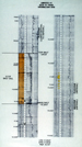
ft thick Late in 1986, less than 20 miles west of
the SMI 200 well (Figures 9,
10, and 11),
the Vermilion 412 Mobil #1 was drilling, again presumably for a deep
Purchasing leases on its "Pooh" prospect
in early 1985, Amoco began a dedicated program of subsalt
exploration that continues to this day (1995). The Vermilion 356
Amoco #1 (Pooh prospect) well (Figures 12
and 13) began in August of 1987 and
drilled to a depth of 17,000 ft after penetrating 2100 ft on the
western edge of a thick Several minor, seemingly unintentional
subsalt tests were drilled during 1988. In an existing field in
Eugene Island 385 and 371, Union Texas drilled the #A-12 and #B-4
wells. The #A-12 penetrated 60 ft of Near the end of 1988, the Green Canyon
184 Conoco #A-12 also encountered a remnant
The Decade of the 1990’s Figures 44-45 (Mississippi Canyon 211)
Late 1989 saw the spudding of the first
of many intentional subsalt wells to come. The State Lease #12878
Amoco #1 well was drilled in the Lake Washington Field - Plaquemine
Parish, in the southeastern onshore Louisiana to a depth of 21,241
ft. After penetrating 4075 ft of A depth of 4352 ft of water is nearly a
mile below the surface of the Gulf of Mexico. As the 1990's began,
Exxon spud a wildcat in this water depth to test a subsalt prospect
below a "shallow" By the spring of 1991, Louisiana was
experiencing the next wildcat for subsalt objectives. In only 36 ft
of water, the Bay Marchand 4 Amoco #1 well was drilled rapidly to a
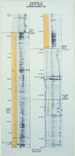
total depth of 18,277 ft after encountering a 4340 ft thick In the fall of 1991, Chevron drilled an
important well just off the edge of the continental shelf in 724 ft
of water, as the Garden Banks 165 Chevron #2 (Figures
16 and 17).
This well was a great technical drilling achievement from the
standpoint that it penetrated nearly 7000 ft of Meanwhile, Garden Banks 260 field
(Baldpate Prospect) had been announced as a significant conventional
discovery for Amerada Hess. However, the Garden Banks 260 Amerada
Hess #1 STH 2 proved to be a subsalt sheet flank test well,
encountering an apparent 1607 ft thick
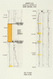
Moving the Play Forward In mid-1993, several significant subsalt tests were to be drilled. Roughly half a dozen companies had purchased leases on prospective subsalt acreage during the late 1980's and early 1990's. Investing significant effort in attempts to prepare these prospects using advanced depth migration processing techniques, these acquisitions represent the dawn of an accelerated period of subsalt drilling activity. Over those past two years, industry drilled no fewer than 15 subsalt sheet or weld tests with one commercial discovery announced to date, and others speculated (Figure 4). Since the Minerals Management Service government regulatory agency does not release wellbore survey data publicly for two years from suspension of well operations, less detailed data is available from these wells with which to demonstrate subsalt concepts. However, a few leases have expired since operations ceased, and under federal guidelines it is required that this data be released. Consequently, where possible this report will detail the results.
Exploration Efforts Produce Commercial Result The most significant result of subsalt
drilling to date (1995) is the discovery announced in October 1993
at the Ship Shoal 349 Phillips #1 "Mahogany" well (Figures
18, 19,
20, and 21,
in only 372 ft of water depth (Harrison et al., 1995). Although
minimal amounts of data have been released, this well was drilled to
a total depth of 16,500 ft and tested at flow rates of up to 7256
BOPD and 9.9 MMCFGPD at a FTP of 7063 psi through a ½ in. choke from
a subsalt sandstone reservoir. Based on interpretation of 2-D
seismic data, this well appears to have penetrated a
Activity Accelerates Rapidly Figure 46 (Garden Banks 128)
Over 60 miles due west of the Mahogany
well, another subsalt test reached total depth of 18,020 ft, at the
end of 1993. Based on 2-D time seismic data, South Marsh Island 169
Amoco #1 (Mattaponi Prospect) (Figures 22
and 23) was drilled on the eastern edge
of a large About the same time as the Mahogany
activity in late 1993, the South Timbalier 260 Phillips #1 (Teak
Prospect) well (Figures 24,
25, 26,
and 27) began in 295 ft of water and
drilled to a total depth of 16,610 ft. As was the case with the
Mahogany block, an old well drilled by a previous operator
encountered a top of As the testing was being conducted on the Teak prospect in early spring of 1994, no fewer than five wells were near spudding with the intent of testing subsalt objectives. At the same time, in early March of 1994, industry paid hundreds of millions of dollars at a federal lease sale for dozens of prospective leases in the subsalt play. It was a very competitive sale with many participants and sizable amounts bid. Vermilion 349 Anadarko #1 (Mesquite
Prospect) (Figures 29 and
30) began in early March of 1994, and
drilled to a total depth of 16,146 ft without encountering any
hydrocarbons. It penetrated a 2460 ft thick Barely three miles to the west of the Mahogany discovery, the Ship Shoal 360 Unocal #2 (Rhino Prospect) (Figures 20, 31, and 32) began in early May and drilled to a total depth of 19,000 ft. A suspension of production (SOP) was obtained by the operator despite having reported no open hole plugs below the last casing depth of 16,985 ft; so it is probable that the qualifying pay zones are behind casing, although the operator did plug and abandon the well without indicating mechanical difficulty. Additional operational activity may be anticipated by the SOP lease extension granted by the MMS past the summer 1994 lease expiration date; thus far (1995) wellbore data has not been released on this well either. Nearly twenty five miles north-northwest
of Mahogany, the Ship Shoal 250 Japex #1 well (Figures
33 and 34)
was drilled to a depth of 17,750 ft after penetrating a 956 ft thick
Ten miles to the south-southwest of the
ST 260 Phillips "Teak" discovery, the South Timbalier 289 CNG #1
(Cypress Prospect) (Figures 28,
35) began in the last days of its five
year lease. Drilled to a total depth of 18,034 ft, the well
penetrated 920 ft of a thick The fifth subsalt (weld?) test well spud in the first half of 1994 occurred barely five miles south of the Mahogany discovery. Ship Shoal 368 Amerada Hess #1 and its two sidetracks (Citation Prospect) (Figures 21, 43) drilled to a total depth of 16,400 ft MD (15,774 ft TVD), where the well was junked and abandoned in early 1995. No additional data has been released on this well, and the lease was still held by 90-day operations, as of press time in early summer of 1995, extending the June 1994 expiration date. According to a partner's quarterly report to shareholders, another possible subsalt discovery may have been made on Garden Banks 128 Shell #1 (Enchilada Prospect) (Figure 36, 46), but no other details have been released. This well drilled to a depth of 18,454 ft MD (17,477 ft TVD) in water depth of 718 ft. Open hole plugs were set below the last casing depth of 12,549 ft, and the well suspended. As of press time, this lease was past its five year primary term, but had been classified as part of a unit. As of this writing, five additional
subsalt tests had spudded in the last quarter of 1994 and the first
half of 1995, and were drilling toward their objective depths.
Vermilion 308 Amoco #1 (South Anna) (Figures
38 and 39)
is projected to a total depth of 20,000 ft in 205 ft of water,
Garden Banks 127 Shell #1 (Chimichanga) (Figures
36 and 37)
is projected to a total depth of 16,000 ft in 622 ft of water,
Garden Banks 216 Amerada Hess #1 STH1 (Penn State Deep) is projected
to a total depth of 20,714 ft MD (18300 ft TVD) in 1611 ft of water,
South Timbalier 308 Marathon #2 (North Lobster) is projected to a
total depth of 18,899 ft MD (16,200 ft TVD) in 564 ft of water, and
Mississippi Canyon 292 Texaco #1 (Gemini) (Figure
40) is projected to a total depth of
14,572 ft in 3393 ft of water. All five of these wells appear to be
pre-planned to penetrate a
Throughout the remainder of the 1990's,
offshore explorers will continue to aggressively pursue this play
because the profit potential is so tremendous, given the reserve
size, existing infrastructure, advancing technology, and attractive
water depths of the northern Gulf of Mexico. Subsalt sandstone
reservoir quality has been repeatedly found to be high porosity,
high permeability, and high pressure, setting the stage for
tremendous production capacity from future discoveries. Thick
sequences of primarily Pliocene, as well as some Pleistocene and
Miocene, sandstone sections reflect subsalt deepwater
paleoenvironments and advance deepwater depositional models.
Additionally, industry is discovering that there is a critical
thickness to the interval drilled below As explorers, we must never forget that "Discovery" is seeing what everybody else has seen, and thinking what nobody else has thought! For if we apply this precept to mature petroleum basins, as in the offshore Gulf of Mexico, it is not difficult to understand how we can find that "There is Life in a "Dead Sea" After All"!!
The authors want to express their appreciation to our managements and colleagues at Anadarko Petroleum Corporation and TGS\CALIBRE Geophysical Company for their encouragement and support in preparing this manuscript. Art Waterman of Paleo Data contributed biostratigraphic data; the Offshore Oil Scout Association contributed basic statistical data, and TGS and Geco-Prakla contributed the seismic data displayed in our oral presentation. Interpretations and opinions expressed by the authors are their own and cannot be attributed to any organizations or other individuals.
Brooks, R. O., and E.H. Denman, 1995,
Changing Styles of Horizontal
Brooks, R.O., and D.J. Hall, 1995, New Structural Concepts for the Deep Miocene, Southern Louisiana Shelf (abs.): AAPG Annual Convention Abstracts, p. 13A.
Brooks, R.O., and D.C. Moore, 1993,
Horizontal Components of Gulf of Mexico
Harrison, H., D.C. Moore, and P.Hodgkins, 1995, The Mahogany Subsalt Discovery: A Unique Hydrocarbon Play, Offshore Louisiana (abs.): AAPG Annual Convention Abstracts, p. 40A.
Melancon, J.M., S.M. Bacigalupi, C.J. Kinler, D.A. Marin, and M.T. Prendergast, 1994, Estimated Proved Oil and Gas Reserves Gulf of Mexico, December 31, 1993: OCS Report MMS 94-0045, U. S. Department of the Interior, Minerals Management Service, Gulf of Mexico OCS Regional Office, New Orleans, Louisiana, August 1994, 50 p.
Copyright © AAPG. Serial rights given by author. For all other rights contact author directly. |