SARIR FIELD SIRTE BASIN, LIBYA
Desert Surprise Then -- and Now Some Keys to Revisit of Libya
Compiled from articles by C. J. Lewis (1990) and R. M. Sanford (1970)
With Database of Field Parameters
Compiled by Jingyao Gong, AAPG Data Systems
Search and Discovery Article #10005 (2000)
Comments of Compiler
Sarir Field, as the largest field in Libya, produces from pre-Upper Cretaceous fluvial sandstones. A significant percentage of its production was sourced by pre-Upper Cretaceous lacustrine (nonmarine beds). The pre-Upper Cretaceous strata underwent deformation before Late Cretaceous development of the Sirte Basin, and that earlier deformation resulted in series of tilted fault blocks with varying extent of preservation of reservoir-type beds. The resulting structural fabric included a prominent westerly trend. Exploration for petroleum in pre-Upper units is undoubtedly aided if it is recognized that the features noted above are in large measure peculiar to these strata.
AAPG and SEPM references of interest to workers involved in exploration, or evaluation, of Libya are given, as a part of this compilation, in addition to the references in the Lewis and Sanford articles.
TEXT
FIELD
CLASSIFICATION
LOCATION
HISTORY
DISCOVERY METHOD
STRUCTURE
STRATIGRAPHY
TRAP
RESERVOIR
SOURCE
EXPLORATION
CONCEPTS
REFERENCES
SUGGESTED
READINGS
SANFORD
REFERENCES
AAPG AND SEPM REFERENCES
APPENDIX
FIGURES
![]() DATABASE OF FIELD PARAMETERS
DATABASE OF FIELD PARAMETERS
![]() Lewis (1990) article in PDF
Lewis (1990) article in PDF
![]() Sanford (1970) article in PDF
Sanford (1970) article in PDF
Sarir Field
FIELD CLASSIFICATION
BASIN: Sirte
BASIN TYPE: Cratonic Sag on Earlier Rifted Basin
RESERVOIR ROCK TYPE: Sandstone
RESERVOIR ENVIRONMENT OF DEPOSITION: Deltaic
RESERVOIR AGE: Cretaceous
PETROLEUM TYPE: Oil
TRAP TYPE: Horst Block
LOCATION
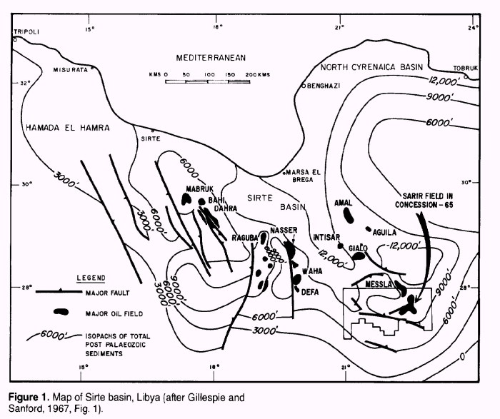
The Sarir or, more specifically, the Sarir "C" field lies on the western edge of
the Calanscio Sand Sea in southern Cyrenaica and is the largest oil field in Libya. It
occurs at the southeastern margin of the Upper Cretaceous-Tertiary Sirte basin or
embayment that contains all the major oil fields of Libya and is the most prolific
oil-producing basin in North Africa (Figure 1). Other
significant fields lying in the same basin are Amal, Gialo, Nasser (Zelten), Defa, Augila,
Hateiba, Messla, Intisar A and D, Bu Attifel, Raguba, and Bahi.
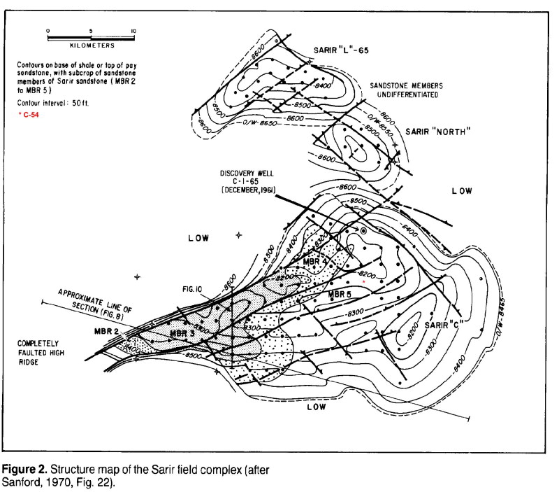
The Sarir "C" field, which is part of a complex of three fields, is 35 mi (56
km) long and 25 mi (40 km) wide covering approximately 146 mi2 (378 km2). To its north
lies the Sarir "L" accumulation, which covers approximately 15 mi2, and situated
approximately between the two, a much smaller Sarir North pool (Figure 2).
Estimated ultimate recovery from the "C" field is 6.5 billion bbl of oil and,
from the "L" field, 1.2 billion bbl, ranking them as the 51st and 201st largest
fields in the compilation of Carmalt and St. John (1986).
HISTORY
Pre-Discovery
The Libyan government granted Concession 65 to Mr. Nelson Bunker Hunt, an independent oil
producer of Dallas, Texas, in December 1957 before any oil had been discovered in the
Sirte basin. In September 1960, a 50% undivided interest in the concession was transferred
to BP Exploration Company (Libya) Ltd., which then became the operator.
In early 1960, after the encouraging, initial discoveries in the Sirte basin in 1958 and
1959, a seismic party began a single-cover, reconnaissance, reflection survey over the
western part of the concession, and in mid-1960, a detailed aeromagnetic survey was flown
over the entire concession. These surveys proved the existence of large structures there.
Also in mid-1960, BP commenced a drilling program in the concessions in which it had
interests on the eastern side of the Sirte basin. These were Concessions 80 and 81 (in
both of which they had a 100% interest) and Concession 65. Large structures similar to
those mapped geophysically in 65 had been found in the other concessions. The main target
was the Paleocene and Cretaceous carbonates that had yielded major discoveries in the
Nasser (Zelten), Defa, Raguba, and Bahi fields. A Cretaceous basal sand discovery had also
been made by Mobil at Amal in 1959, but early results did not recognize then the full
potential of that field.
Before the Sarir discovery well was drilled at C-1-65, BP had drilled six major tests to
basement in Concessions 65, 80, and 81. None of these had any encouraging hydrocarbon
shows. The Eocene, Paleocene, and Cretaceous carbonates, which had produced oil elsewhere,
were generally freshwater bearing, and the basement highs were draped in a thick sequence
of black Upper Cretaceous shales. Occasionally, there were vestiges of "redbeds"
at the shale-basement contact and some bituminous veining. Many of the wells proved
difficult and expensive to drill due to extensive lost circulation problems in the
Paleocene-Cretaceous carbonates and massive caving in the underlying Upper Cretaceous
shales. These problems were very severe on C-1-65, and, at one time, it was considered a
possibility that the well should be abandoned before reaching the projected total depth.
However BP's chief geologist had an almost fanatical obsession, which was also a very wise
one, in insisting that a core of basement be taken in every well. In all events, had
C-1-65 been dry, it would probably have been the last major test the partners drilled
before abandoning operations in Libya.
Discovery
The actual first recognition of the discovery of the Sarir field makes an interesting
story. For years BP had been cool to the use of gas detectors on its rigs. It claimed,
with some justification, that they caused too many false alarms. However, in late-1961,
Baroid were brought in to set up gas detectors on BP's Libyan wells. A demonstration was
given on C-1-65, when drilling was taking place in the "caving Cretaceous
shales," for all the rig-site geologists to witness. The gas detector gave very high
readings the moment it was switched on. This was immediately assumed to be a typical gas
detector false alarm, but, when the whole apparatus was cleaned out and new elements
fitted, the same high readings persisted. Then, on carefully examining the samples of
"shale cavings," at the bo tom of the plates were found loose grains of
oil-stained sand. Approximately 200 ft (61 m) of oil pay had been drilled!
The top of the pay in Upper Cretaceous sandstones occurred at 8632 ft (2631 m). The well
produced on drill-stem test at a rate of 3900 BOPD.
Post-Discovery
The first well proved an oil column of over 250 ft (76 m), much greater than the predicted
closure for the shallow reflection structure on which it was located. Although the seismic
map thus gave an indication of the structure, it could not be relied on in detail at the
top of the reservoir some 5500 ft (1676 m) below. Therefore, while the second and third
wells were being drilled, a detailed seismic refraction survey on a 5 km grid was shot
over the area. The survey gave control over the basement structure, but since the first
four wells proved that the reservoir sands varied from 463 to 1345 ft (141 to 410 m) in
thickness over a relatively short distance, the refraction survey did not give much
control over the trapping structure at the top of the sandstones. The combined use of the
seismic maps on both horizons and the ever-increasing subsurface information gave a good
guide to the reservoir structure and kept the number of dry holes drilled to a minimum.
Later, experimental sixfold cover was only partially successful in that, while a good deep
reflection could be mapped, this reflection did not correspond to the top of the sands.
After the discovery, continuous drilling of the field took place with up to five rigs at a
time. Relatively short outsteps of up to 4 km were made at first, then bolder ones were
drilled to confirm the presence of sufficient reserves to justify the tremendous capital
cost of a 321 mi (516 km) pipeline to Tobruk. Once sufficient reserves had been confirmed,
the field was steadily drilled up on a 2 km grid spacing.
During this time, exploration of the rest of Concession 65 resulted in the discovery of
the two smaller fields in the Sarir complex: the Sarir North and L-65 fields.
Initial production rates of wells on the main Sarir field averaged 8000 BOPD, but some
were able to achieve a maximum rate of 20,000 BOPD. Because the field has no gas cap and
GORs vary between 60 and 225 static ft3 (1.7 and 6.4 m3) per barrel, pressure maintenance
was a problem that had to be addressed early in the life of the field. Shallow supplies of
fresh water were used, which was plentifully available from about 150 ft (46 m) down to
1700 ft (518 m). Downhole pumps were also used in some areas to maintain production.
Because relatively large amounts of salt became entrained in the crude during production
and reached levels that could not be tolerated by many refineries, desalters had to be
added at an early stage. This is a common occurrence with production from most, if not
all, the major Libyan fields.
The gravity of the crude is 37° API, its wax content is 19%, and the sulfur content is
below 0.25%. Further comment on the properties of wax in the Sarir crude is found in
Brunnock (1966).
Initial, in-place reserves of the main field were estimated to be approximately 12 billion
bbl of oil, of which 6.5 billion should be recoverable along with some 1 tcf of gas.
Accurate production figures since 1971, when the field was appropriated by the Libyan
government, are not available, but it is estimated that 1.5 billion bbl of oil had been
produced by 1983.
DISCOVERY METHOD
Sarir is unquestionably a discovery based predominantly on geophysical methods aided
during the later stages by subsurface geology as wells were drilled on neighboring
structures. No topographic or geomorphic anomalies in the area are reported in the
literature. There are no indications (seeps) recorded for the area.
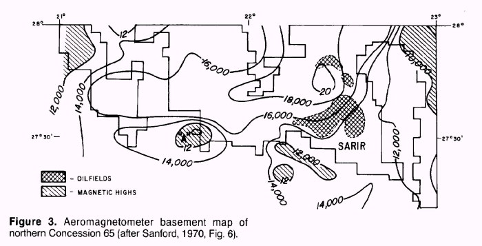
The air magnetometer revealed the presence of the large southwestern area "A"
structure and its southeastern prolongation, which subsequently was found to be a buried
major fault line. Sarir field, superimposed on this map, was not detectable as an anomaly
on the basis of this magnetic survey (Figure 3).
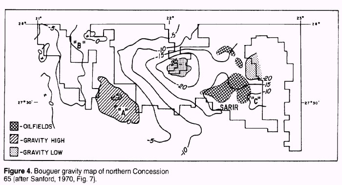
Gravity coverage followed that also outlined major features, although Sarir, located on
the northwest plunge of a gravity maximum axis, is definitely overshadowed by two features
to the west. One of these, a large gravity maximum, became the "A" structure;
the other, a strong gravity maximum, the "B" structure. The eastern feature,
rising to a gravity maximum, was called the "C" structure; it later became known
as the Sarir "C" Field (Figure 4).
Seismic reflection and refraction surveys made in late 1960 and early 1961 also show major
structural features. The "C" structure, within the Sarir producing complex,
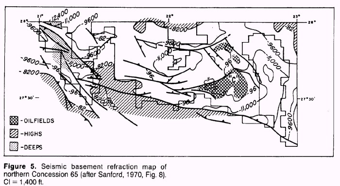
shows up as a pronounced basement feature (Figure 5). A
shallow 3000 ft (914 m) Eocene seismic reflection horizon was mapped at the same time and
showed only a few hundred feet of relief over the Sarir complex, in contrast to the
refraction map, which showed up to 2000 ft (610 m) of relief.
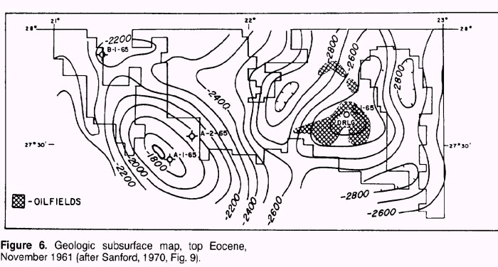
After the drilling of the first two wells in the concession on the prominent "A"
and "B" structures, both of which were dry holes with no significant hydrocarbon
shows, it was possible to construct a top of Eocene map that showed "C" as a
very large structure with 300 ft of closure (Figure 6).
This was considered sufficient justification to proceed with drilling.
STRUCTURE
The Sirte basin or embayment is the youngest of the Libyan basins and the only one, to
date, in which significant accumulations of hydrocarbons have been found. The essentially
upper Mesozoic and Tertiary feature developed on a Precambrian basement and eroded
Paleozoic surface. The main northwest to southeast synclinal trough underwent repeated
subsidence with accompanying fault adjustments. Several regional horst-and-graben trends
that began to develop in Cenomanian (Late Cretaceous) time remained active during, at
least, the Tertiary as the basin continued to subside.
Following the compilation of a list of hydrocarbon provinces of the world by St. John et
al. (1984), the Sirte basin is classified as 1211 under the modified scheme of Bally and
Snelson (1980) (i.e., a cratonic basin located on earlier rifted grabens on a rigid
lithosphere and not associated with formation of megasutures). This would assume that the
basin had earlier origins than the Cretaceous, which may well be the case although
compelling evidence of this seems to be lacking at present. It is also classified as 3A
using the scheme of Klemme (1971) (i.e., a continental rifted basin; craton and accreted
zone rift). Clifford (1986) terms the Sirte basin an interior fracture basin near the
plate margin, which characteristically has an axis at an angle to that margin. These
basins are c used by extensional shear and commonly show horst-and-graben development,
often having the better reservoirs associated with the highs and the better source rocks
associated with the lows throughout basin development. There is usually an initial
restricted stage during which coarse, nonmarine clastics and lacustrine shales accumulate.
A mature, semirestricted stage follows, with widespread occurrence of rich source rocks,
good reservoirs--both clastic and carbonate--together with evaporites. Structural
rejuvenation occurs during this mature stage. Higher than average temperature and heat
flow are normally associated with these basins.
Although the predominant trend of the faults is northwest to southeast following the
general trend of the Sirte basin, there are also important northeast to southwest trends
that may form part of a conjugate pattern controlled by the gross texture of basement.
Many of the structures may be the result of differential movement of these basement
"blocks."
In pre-Cretaceous times, the areas that would eventually become the sites of the Sarir
accumulations were occupied by topographic highs (Figure 2).
It is probable that, even at this time, these highs were controlled by sets of conjugate
faults trending northwest to southeast and northeast to southwest.
However, the southern part of the "C" structure may still have been connected to
a much larger hinterland from which the main supply of Cretaceous sediments were derived
and which subsequently subsided.
Major fault movement occurred during the deposition of the Cretaceous (reservoir) sands (Figure 6a, Figure 6b, Figure 6c). This is especially evident on the north and
west flanks of the "C" structure, which at the end of the sandstone deposition
were subject to pronounced uplift and erosion. This is expressed by a disconformity that
removed successively deeper reservoir beds to the north and west.
Major downwarping to the south probably originated toward the close of the Cretaceous,
isolating the structure from its hinterland, forming it into a trap, and providing a deep
shale trough that may have been one of the main hydrocarbon generating areas.
During the Tertiary, there appeared to be little major fault movement, but differential
compaction resulted in a relatively simple anticline draped over the underlying Cretaceous
structure.
The "C" structure, at basement level, is less pronounced than those to the south
and northwest, which have been drilled but have been found to have poor sand development
or to be bald-headed, in that the Upper Cretaceous shales rest directly on basement
without the intervening sandstone reservoir of the Sarir field.
The fall from the crest of the "C" structure to the southern low is 270 msec,
about 1000 m. This fall occurs over a distance of about 22 km and is equivalent to an
overall dip of 2.5°. The steepest dip recorded is 4.5°. The triangular-shaped crest has
an east-west base roughly 40 km long and a north-south perpendicular of 20 km. Vertical
closure is approximately 400 ft (122 m).
The Sarir North and L-65 fields are located on a northwest extension of the northeast side
of the main ("C") structure. The northernmost accumulation, L-65, has a
triangular shape more marked than the "C" structure with a strong
southwest-trending flank.
The structural evolution of the Sarir complex was essentially marked by vertical tectonic
movement. There is little or no evidence of any horizontal stresses being involved.
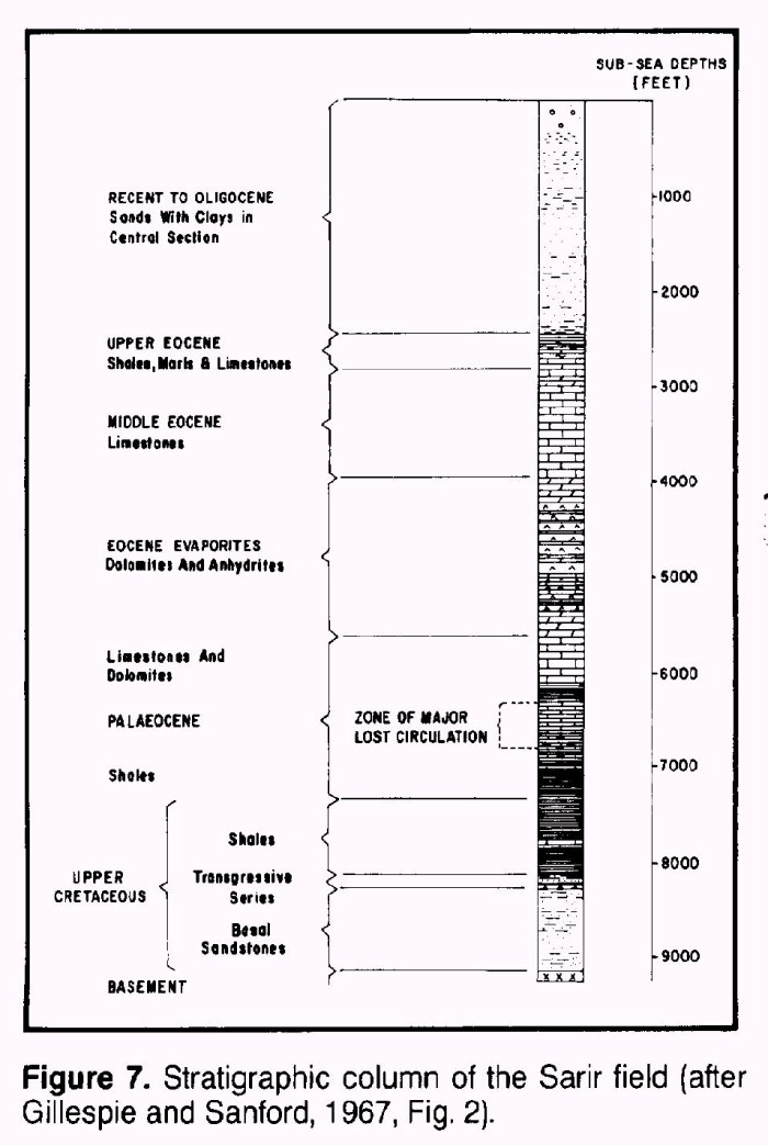
STRATIGRAPHY
The stratigraphic column of the Sarir field area is generally representative of the
succession throughout the Sirte basin, although there are some important local variations.
It is summarized in Figure 7.
During the initial regressive phase, basal sandstones that contain the main reservoir at
Sarir were deposited on a basement consisting essentially of Precambrian igneous and
metamorphic rocks. However, in parts of the basin, eroded remnants of Paleozoic rocks are
present. The sandstones are dated on angiosperm pollen as being not older than uppermost
Lower Cretaceous (Albian) and are probably of Upper Cretaceous age. North of Sarir, the
sandstones are seen to thin into the basin and are generally absent through erosion on
many of the large structures there.
After a significant hiatus that is represented by a marked unconformity at Sarir and
erosion of basal sandstones, a transgressive sequence or series consisting predominantly
of red, green, and purple anhydritic shales was laid down. Remnants of these variegated
beds are found in the crestal parts of several of the more northerly structures, such as
in wells B-1-65 and C-1-80 (in the original concession directly to the north of 65).
Above the transgressive sequence are thick Upper Cretaceous shales with tight, micritic
carbonate, marking the top of the Mesozoic. The shales thicken significantly into the
troughs and are widely thought to provide the best source rocks and the sole source rock
for the Sarir field. The youngest fauna are identified as being of Maastrichtian (Upper
Cretaceous) age, and there would appear to be a slight disconformity between the Upper
Cretaceous and the Paleocene, which is marked by a high level of gamma radiation on the
logs.
The Paleocene is also a carbonate-shale succession with major carbonate (reefal) build-ups
over structural highs that form some of the best reservoirs in the basin. Although thick
carbonates are present over the Sarir field and other highs in Concession 65 and the
immediately surrounding area, no hydrocarbons have been found trapped in them. Generally,
the water in the reservoirs is fresh to brackish, suggesting flushing. The limestones have
been extensively dolomitized, resulting in large cavities being formed, which caused
serious lost circulation problems while drilling.
In the lower Eocene, conditions in the basin again became restricted, leading to the
deposition of a sequence of alternating dolomites and anhydrites, which is very consistent
in thickness. Individual beds can be traced over large distances.
The middle Eocene saw the development of a widespread carbonate platform, richly
fossiliferous (nummulitic), which, again, is remarkably constant in thickness. There are
interbeds of argillaceous limestone and marl and occasional calcareous sandstones.
The upper Eocene reflects more frequent lateral variations and consists of interbedded
limestones, dolomites, marls, and shales. In the Sarir field area, it has thinned to less
than 100 ft (30 m).
The Recent to Oligocene succession consists of a lower zone of fine to coarse sands with
some clay partings and dolomite beds, a middle zone of gray-green, red-brown shales and
clays, and an upper zone of largely unconsolidated, slightly feldspathic sands. This
sequence is typical of the Sarir field area where total thickness is approximately 3000 ft
(914 m), being almost equally divided into the three main components. Further north in the
Sirte basin, carbonate development becomes extensive, especially in the eastern part.
TRAP
The main Sarir accumulation is contained in a combination structural-stratigraphic trap.
The structural components are represented by dip to the east, south, and west and to some
extent by the major northeast-southwest-trending fault on its northwest flank. However, in
much of the central and northwestern part of the field, the reservoir subcrops and is
sealed by shales that unconformably overlie it.
The minor accumulations in individual sands in the transgressive series directly above the
basal sands occur in updip, pinchout traps that are purely stratigraphic.
The main trap of Sarir "C" is not full to spill point which lies downplunge on
the ridge leading west from the structure. The maximum height of the oil column is 300 ft
(91 m) compared to the vertical closure of 400 ft (122 m).
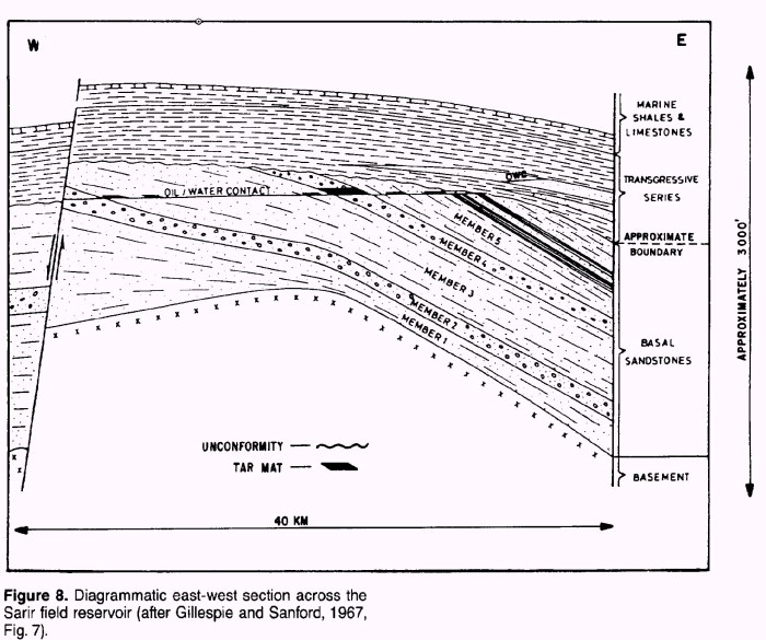
Within the trap, the distribution of the crude is affected by lithological variation in
the reservoir. There appears to be a common oil-water level in the main reservoir members,
but that in the transgressive series is observed to be some 140 ft (43 m) higher (Figure 8).
The Sarir North field is a separate trap with its own oil-water contact some 100 ft (30 m)
deeper than that of the main "C" field. L-65 also has its own independent
oil-water contact (Figure 2).
There is no gas cap in the field, and the crude has a low gas-oil ratio that varies
between 60 and 225 standard ft3/bbl across the field. Within the accumulation there has
been some differentiation of the crude, probably due to gravity separation with time, with
the result that its properties are variable. Overall, however, it is a fairly light, waxy
crude with a mean gravity of 37° API, wax content of 19%, and a uniformly low sulfur
content of less than 0.25%. The pour point is
high and varies from 55° to 75°F (12° to 24°C).
Gravity segregation of the crude within the trap has led to the formation of a peripheral
"tar mat" in the more permeable intervals of the reservoir where they intersect
oil-water level. The "tar mat" is variable in thickness and reaches a known
maximum of 70 ft (21 m) in the east of the field.
Samples of very viscous oil obtained from the top of the "tar mat" have a mean
gravity of 24°-25° API, a pour point of about 160°F (71°C), a wax content of 15%, and
an asphaltine content of 14%-22%.
The basal sandstone reservoir of the Sarir field is thought to be of fairly limited
extent. As a continuous development it is contained between basement and the shaly, higher
Upper Cretaceous beds. It is not known to be in open contact with any other formation.
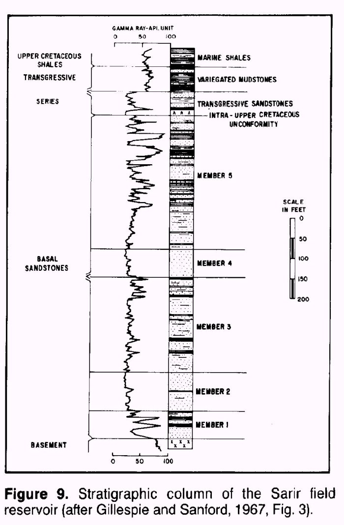
RESERVOIR
The detailed sequence of the Sarir basal sandstone reservoir is described using the text
and illustrations taken from Gillespie and Sanford (1967). The basal sandstones are the
main reservoir of the field. They are far from homogeneous and have been subdivided into
five members, three of shaly or tight sandstone separated by two clean sandstone units (Figure 9). Because the present distribution of these
members and their various properties have a considerable effect on the distribution of oil
within the trap, they will be described individually.
The thickness of the basal sandstone as a whole varies considerably, from 463 to 2061 ft
(141 to 628 m). The overall variation results from a combination of three main factors:
internal thickness variation within the individual members, the severity of the
postdepositional erosion, and the initial configuration of the basement surface.
From the top downward the five members (Figure 9, Figure 9a, Figure 9b)
are:
Member 5:
0-460 ft (0-140 m). This member is absent over much of the field and occurs as an outward
thickening fringe along the margins of the main structure. The partial absence of the
member is considered to be due to postdepositional erosion rather than to nondeposition
because the satisfactory correlations established between downflank well sections indicate
that as the member thickens off the structure, this thickening is largely made up by the
appearance of even younger beds at the top of the member.
This is a very variable interval consisting of white to red-brown, poorly cemented,
fine-to coarse-grained sandstones and shaly sandstones with interbedded red and green
shales and sandy mudstones. Although generally tight and unattractive as a reservoir, it
contains several porous and permeable beds, and where these occur above the oil-water
contact, they do produce.
Member 4:
67-111 ft (20-34 m) (where fully preserved). This is the upper clean sand interval (Figure 9c) that separates the variably tight sands of
Member 3 and the shalier sands of Member 5. It is white to buff, clean,
medium-coarse-grained, occasionally fine-grained, poorly sorted, poorly cemented, friable,
sheet sandstone with good porosity (15%-20%) and good permeability (greater than 100 md).
There are occasional shale laminae, and where the member is truncated by an unconformity,
patches of anhydrite contamination occur from the base of the Transgressive Series.
With the overlying conformable Member 5, Member 4 has been completely eroded off the crest
and is present only on the flanks of the structure. It is the main reservoir interval of
the sequence.
Member 3:
233-820 ft (71-250 m) (where fully preserved). Member 3 is capped and underlain by clean
sand members and consists of alternating porous and tight sandstones, with only occasional
shales. The clean sand intervals are similar to Member 4. The nonporous sands are tightly
cemented with a clay matrix. Although correlation within the member is difficult, some of
the mudstone and tight sandstone intervals persist over areas of several tens of square
kilometers.
Member 3 is present over the whole field and has only been partially eroded over the crest
of the structure. Prior to the erosion, Member 3 appears to have been thinnest in the
eastern part of the field and to have thickened outward from there. The uplift and
subsequent erosion of this member in the western part of the field gives a rather complex
thickness distribution.
The porous intervals in Member 3 form good reservoirs. They are generally 20-30 ft (6-9 m)
thick (seldom over 50 ft [15 m]) and have porosity and permeability characteristics
similar to the Member 4 sands.
Member 2:
95-268 ft (29-82 m). This is a fairly uniform clean sand similar to Member 4, but it tends
to become slightly shaly in the lower part. The member is completely present over the
whole field and thickens from east to west across the field, as did Member 3 originally.
Only in the extreme west does the unit occur above the oil-water contact and give
production.
Member 1:
55-1004 ft (17-306 m). The basal unit of the sedimentary succession consists of
alternating sandstones, mudstones, and siltstones. On the whole, it is much shalier than
the upper members. It is completely present over the structure but varies considerably in
thickness. Like Members 3 and 2, it thickens from east to west over the field. The extreme
thickness variation in this member is probably due to the infilling of an irregular
basement topography by these initial deposits. This unit does not occur above the
oil-water contact in the field.
It appears that no detailed work has been done on the depositional environment of these
basal sands. They are almost certainly of deltaic origin and may have been much more
widespread prior to uplift and erosion in the Upper Cretaceous. They, in turn, were
probably derived from older Paleozoic clastics, remnants of which are found some 50 km to
the east in Concession 81.
There is also a lack of petrographic descriptions of the reservoir, and no reference is
given to the part, if any, played by clays and cements in its development. It would appear
that the original porosity and permeability have been largely preserved. There is little
evidence of secondary porosity having played any significant role in the development of
the reservoir. Good quality water-wet reservoirs were encountered and cored in J-1A-65
some 30 km to the west of Sarir.
SOURCE
The Sarir complex was discovered before the major advances in source rock geochemistry
that have been made over the past 15 years. Few, if any, studies of this type were carried
out before the fields were taken over by the Libyans in 1971, since which time there has
been sparse information available about the field. It is suspected that, were this
information available, a fairly straightforward identification and description of the
source beds would have been made.
The following observations are offered based on the early years of the fields' history.
The hydrocarbons trapped in the Sarir complex must be of local origin and derivation, the
fields being situated on early established structural highs. They are thus considered to
have their source in the marine shales of the Upper Cretaceous and to have migrated into
the reservoirs from the deep basins surrounding the fields.
Migration probably commenced in the early Tertiary when the source rocks would have been
sufficiently buried to attain maturity for oil generation.
EXPLORATION CONCEPTS
The play concept supporting the Sarir field is one in which basal sandstones are preserved
in an anticline, controlled essentially by vertical movements in basement, and overlain
unconformably by shales that provide both adequate source rock and seal. The Amal field on
the west side of the Sirte basin, further north, can probably be classified as being in
the same play, as are the smaller Sarir fields and several others on the west side of the
basin. There are many other large, apparently closed structures in the play area, which
are lacking the basal sandstone reservoir.
Detection of the reflector that subsequently proved to mark a horizon near the top of the
basal sandstone reservoir was not possible using the geophysics available at the time of
discovery, but modern techniques and technology should greatly improve the situation.
Indeed, CDP lines shot in the late 1960s were already demonstrating that this was possible
in areas of development drilling in the field (Figure 10,
Figure 10a, Figure 10b).
It is unlikely that any further fields of the size of Sarir will be found in the play
area, but the chances are favorable that additional smaller-sized discoveries of this type
have yet to be made there.
This type of play is common to many other productive basins in the world and has yielded
several of the largest fields. One field of strong similarity is Prudhoe Bay in Alaska,
which also overlies a large southward-tilted basement block, strongly fault-bounded to the
north, with the basal reservoirs overlain unconformably by shales that have provided both
source and seal.
Based on our current knowledge, any untested structures that are mapped, which have the
essential ingredients of this model, should be prime targets for "elephant
hunting."
REFERENCES
Bally, A. W., and S. Snelson, 1980, Realms of subsidence, in Facts and principles of world
petroleum occurrence: Canadian Society of Petroleum Geologists Memoir 6, p. 9-94.
Brundage, H. T., 1965, Libya becoming one of the world's top oil and gas exporters: World
Oil, v. 161, n. 3, p. 68-71.
Brunnock, J. V., 1966, Distribution of normal paraffins in Libyan and Nigerian crude oils:
Nature, v. 212, n. 5060, p. 385-387.
Carmalt, S. W., and B. St. John, 1986, Giant oil and gas fields, in M. T. Halbouty, ed.,
Future petroleum provinces of the world: American Association of Petroleum Geologists
Memoir 40, p. 11-54.
Clifford, A. C., 1986, African oil--past, present and future, in M. T. Halbouty, ed.,
Future petroleum provinces of the world: American Association of Petroleum Geologists
Memoir 40, p. 339-372.
Conant, L. C., and G. H. Goudarzi, 1967, Stratigraphic and tectonic framework of Libya:
American Association of Petroleum Geologists Bulletin, v. 51, n. 5, p. 719-730.
Gillespie, J., and R. M. Sanford, 1967, The geology of the Sarir oil field, Sirte Basin,
Libya, in Proceedings 7th World Petroleum Congress, v. 2, p. 181-193.
Klemme, H. D., 1971, What giants and their basins have in common: Oil and Gas Journal, v.
69, n. 9,10,11; pt. 1, p. 85-90; pt. 2, p. 103-110; pt. 3, 96-100.
Parsons, M. G., A. M. Zagaar, and J. J. Curry, 1979, Hydrocarbon occurrence in the Sirte
Basin, Libya, in Facts and principles of world petroleum occurrence: Canadian Society of
Petroleum Geologists Memoir 6, p. 723-732.
Sanford, R. M., 1970, Sarir oil field, Libya--desert surprise, in M. T. Halbouty, ed.,
Geology of giant petroleum fields: American Association of Petroleum Geologists Memoir 14,
p. 449-476.
St. John, B., A. W. Bally, and H. D. Klemme, 1984, Sedimentary provinces of the world,
hydrocarbon productive and nonproductive: American Association of Petroleum Geologists Map
Series, 35 p.
SUGGESTED READINGS
Gillespie, J., and R. M. Sandford, 1967, The geology of the Sarir oil field, Sirte Basin,
Libya, in Proceedings 7th World Petroleum Congress, v. 2, p. 181-193.
Sanford, R. M., 1970, Sarir oil field, Libya--desert surprise, in M. T. Halbouty, ed.,
Geology of giant petroleum fields: American Association of Petroleum Geologists Memoir 14,
p. 449-476.
Barakat, M. G., 1960, Major tectonic elements of Matzen oil field, Vienna
basin: Jour. Geology United Arab Republic, v. 4, p. 19-25.
British Petroleum Co., and Hunt International Petroleum Co., unpublished reports.
Conant, L. C., and G. H. Goudarzi, 1967, Stratigraphic and tectonic framework of Libya:
Am. Assoc. Petroleum Geologists Bull., v. 51, no. 5, p. 719-730.
Hardin, F. R., and G. C. Hardin, Jr., 1961, Contemporaneous normal faults of Gulf Coast
and their relation to flexures: Am. Assoc. Petroleum Geologists Bull., v. 45, no. 2, p.
238-248.
Ocamb, R. D., 1961, Growth faults of South Louisiana: Gulf Coast Assoc. Geol. Socs.
Trans., v. 11, p. 139-176.
Pomeyrol, R., 1968, "Nubian Sandstone": Am. Assoc. Petroleum Geologists Bull.,
v. 52, no. 4, p. 589-600.
Al-Shaieb, Zuhair, John W. Shelton, 1978, Secondary Ferroan Dolomite Rhombs in Oil
Reservoirs, Chadra Sands, Gialo Field, Libya: AAPG Bulletin , Vol. 62, p. 463 - 468.
Bebout, D. G., and Charles Pendexter, 1975, Secondary Carbonate Porosity
as Related to Early Tertiary Depositional Facies, Zelten Field, Libya:
AAPG Bulletin , Vol. 59, p. 665 - 693.
Bishop, William F., 1975, Geology of Tunisia and Adjacent Parts of Algeria and Libya: AAPG Bulletin , Vol. 59, p. 413 - 450.
Brady, T. J., N. D. J. Campbell, C. E. Maher, Intisar 'D' Oil Field, Libya in M 30: Giant Oil and Gas Fields of the Decade 1968-1978, p. 543 - 564
Brennan, Philip, 1992, Raguba Field--Libya Sirte Basin, in AAPG treatise of petroleum geology, Atlas of oil and gas fields, Structural Traps, Vol. VII, p. 267 - 289.
Clifford, Harold J., Roger Grund, and Hassan Musrati, Geology of a Stratigraphic Giant: Messla Oil Field, Libya, in M 30: Giant Oil and Gas Fields of the Decade 1968-1978, p.507 - 524 .
Conant, Louis C., and Gus H. Goudarzi, 1967, Stratigraphic and Tectonic
Framework of Libya: AAPG Bulletin , Vol. 51, p. 719 - 730.
Eicher, D. B., J. S. Royds, and J. F. Mason, 1975, Africa: Chapter 22: PART II. LIBYA, in
M 6: Track of the Oil Finders: A History of Exploration for Petroleum, p. 1436 - 1445.
Gumati, Yousef D., and William H. Kanes, 1985, Early Tertiary Subsidence and Sedimentary
Facies--Northern Sirte Basin, Libya: AAPG Bulletin , Vol. 69, p. 39 - 52.
Lewis, C. J., 1990, Sarir Field in Structural Traps II, Treatise in petroleum geology, Atlas of oil and gas fields: AAPG Treatise in Petroleum Geology, p. 253-267.
Roberts, J. M., 1970, Amal Field, Libya, in M 14: Geology of Giant Petroleum Fields, p. 438-448.
Sanford, Robert M., 1970, Sarir Oil Field, Libya--Desert Surprise in M 14: Geology of Giant Petroleum Fields, p. 449-476.
Van Houten, F. B., and R. M. Karasek, 1981, Sedimentologic Framework of Late Devonian Oolitic Iron Formation, Shatti Valley, West-Central Libya: Jour. Sedimentary Petrology, Vol. 51 ,Iss. No. 2. (June), p. 415-427.
Whitbread, T., and G. Kelling, 1982, Mrar Formation of Western Libya--Evolution of An Early Carboniferous Delta System : AAPG Bulletin , Vol. 66, p. 1091 - 1107.
Williams, J. J. 1972, Augila Field, Libya: Depositional Environment and Diagenesis of Sedimentary Reservoir and Description of Igneous Reservoir: Case Histories , in M 16, Stratigraphic Oil and Gas Fields--Classification, Exploration Methods, and Case Histories, p.623 - 632.
APPENDIX
Appendix 1. Field Description
Field name: Sarir
Ultimate recoverable reserves: 6.5 billion bbl
Field location:
Country: Libya, North Africa
State: Cyrenaica
Basin/Province: Sirte basin
Field discovery:
Year field discovered: 1961
Year second pay discovered: NA
Third pay: NA
Discovery well name and general location:
(i.e., Jones No. 1, Sec. 2T12NR5E; or Smith No. 1, 5 mi west of Sheridan, Wyoming):
First pay: C-1-65 27°38^prime35^PrimeN, 22°31^prime23^PrimeE
Second pay: NA
Third pay: NA
Discovery well operator: BP Exploration Co. (Libya) Ltd.
(if more than one pay in field, list operators of discovery well in other pays)
Second pay: NA
Third pay: NA
IP in barrels per day and/or cubic feet or cubic meters per day:
First pay: 100,000 BOPD
Second pay: NA
Third pay: NA
All other zones with shows of oil and gas in the field:
Table
Geologic concept leading to discovery and method or methods used to delineate prospect,
e.g., surface geology, subsurface geology, seeps, magnetic data, gravity data, seismic
data, seismic refraction, nontechnical:
Structure inferred and mapped using a combination of magnetic data, gravity data, seismic
data, seismic refraction, and subsurface geology using wells drilled on neighboring
structures.
Structure:
Province/basin type (see St. John, Bally, and Klemme, 1984)
Bally 1211; Klemme IIIA
Tectonic history
Interior fracture basin near plate margin, originated or rejuvenated in Early Cretaceous
with major uplift and erosion in Late Cretaceous with movement continuing but diminishing
until at least Oligocene.
Regional structure
Field lies in southeastern part of Sirte basin. Structural development controlled by
basement fault system.
Local structure
Main Sarir structure is flat crest of an uplifted block, bounded on the northwest and
northeast by faults and dipping gently away to the east, south, and southwest.
Trap
Trap type(s)
Faulted anticlinal trap with one pay. Small pinchout traps in overlying Transgressive
series (insignificant).
Basin stratigraphy (major stratigraphic intervals from surface to deepest penetration in
field):
Table
Location of well in field: Composite of maximum thicknesses of field wells
Reservoir characteristics:
Number of reservoirs: 2
Formations: Basal sandstones (primary); Transgressive series (secondary)
Ages: Late Early Cretaceous to early Late Cretaceous
Depths to tops of reservoirs: 8596 ft (2620 m) Basal sandstones
Gross thickness (top to bottom of producing interval)
450-2000 ft (137-610 m) (oil column less than 300 ft; 91 m)
Net thickness--total thickness of producing zones
Average: NA
Maximum: NA
Average
Maximum
Lithology
Medium- to coarse-grained, friable sheet sandstone. Sandstone divisible into 5 members: 5
(generally tight), 4 (most permeable), 3 (alternately porous and tight), 2 (permeable), 1
(shaly sandstone).
Porosity type: Intergranular porosity
Average porosity: 18-19%
Average permeability: 200-300 md
Seals:
Upper
Formation, fault, or other feature: Upper Cretaceous shales
Lithology: Shales, minor evaporites
Lateral
Formation, fault, or other feature: Pinchout into shales (for Transgressive series)
Lithology: Red-brown, gray-green shales
Source:
Formation and age: Upper Cretaceous shales
Lithology: Black shales
Average total organic carbon (TOC): Not known
Maximum TOC: Not known
Kerogen type (I, II, or III): Not known
Vitrinite reflectance (maturation): Not known
Time of hydrocarbon expulsion
Probably upper Tertiary, assuming expansion at same time as other Sirte basin fields.
Present depth to top of source: 7500 ft (2286 m)
Thickness: 750-2000+ ft (?) (229-610 m)
Potential yield: NA
Appendix 2. Production Data
Field name: Sarir
Field size:
Proved acres: 95,000 ac (38,445 ha.)
Number of wells all years: 88 drilled by 1970
Current number of wells: NA
Well spacing: 2 km
Ultimate recoverable: 6500+ million bbl
Cumulative production (1983): 1500 (?) million bbl
Annual production (1983): 243 (?) million bbl
Present decline rate: NA
Initial decline rate: NA
Overall decline rate: NA
Annual water production: NA
In place, total reserves: 12,000 million bbl
In place, per acre-foot: 600±
Primary recovery: 3000 million bbl
Secondary recovery: 6500+ million bbl
Enhanced recovery: NA
Cumulative water production: NA
Drilling and casing practices:
Amount of surface casing set: 3000 ft (914 m)
Casing program
Surface casing 13 3/8-in. to 3000 ft (914 m); 9 5/8-in. to 7000 ft (2134 m); 7-in. to 9000
ft (2743 m)
Drilling mud
Bentonite with various additives to 6400 ft, then water through loss zone XP 20 below.
Bit program: Varies
High pressure zones: None
Completion practices:
Interval(s) perforated: Generally from top of pay to 50 ft (15 m) above OWC
Well treatment: NA
Formation evaluation:
Logging suites: Generally ran full suites at intermediate and bottom casing points
Testing practices: Standard
Mud logging techniques: No comment
Oil characteristics:
Type: NA
(Tissot and Welte Classification in "Petroleum Formation and Occurrence," 1984,
Springer-Verlag, p. 419)
API gravity: 36.8°
Base: NA
Initial GOR: 143 standard ft3/bbl
Sulfur, wt%: 0.25
Viscosity, SUS: NA
Pour point: 55-75°F (13-24°C)
Gas-oil distillate: NA
Field characteristics:
Average elevation: 400 ft (122 m)
Initial pressure: 3924 psi (27,156 kPa)
Present pressure: NA
Pressure gradient: NA
Temperature: 90+°F (32°C)
Geothermal gradient: NA
Drive: Water
Oil column thickness: 300 ft (91 m)
Oil-water contact: 8465 ft (2580 m)
Connate water: NA
Water salinity, TDS: 195,000 ppm
Resistivity of water: NA
Bulk volume water (%): NA
Transportation method and market for oil and gas:
310 mi (499 km) pipeline to Tobruk.
Fig. 1. Map of Sirte basin, Libya (after Gillespie and Sanford, 1967, Fig. 1).
Fig. 2. Structure map of the Sarir field complex (after Sanford, 1970, Fig. 22).
Fig. 3. Aeromagnetometer basement map of northern Concession 65 (after Sanford, 1970, Fig. 6).
Fig. 4. Bouguer gravity map of northern Concession 65
(after Sanford, 1970, Fig. 7).
Fig. 5. Seismic basement refraction map of northern
Concession 65 (after Sanford, 1970, Fig. 8). CI = 1,400 ft.
Fig. 6. Geologic subsurface map, top Eocene, November 1961 (after Sanford, 1970, Fig. 9).
Fig. 7. Stratigraphic column of the Sarir field (after Gillespie and Sanford, 1967, Fig. 2).
Fig. 9a. (Sanford Fig. 23)--North-south section of Sarir pay.