![]() Click to view file in PDF format.
Click to view file in PDF format.
Misener Sandstone of Oklahoma
Masera Corporation
(Michael D. Kuykendall* and Richard D. Fritz**, principal investigators)
Search and Discovery Article #10018 (2001)
Summarized and adapted for online presentation from report, entitled “Misener Sandstone of Oklahoma, Phase I,” prepared by Masera Corporation, Tulsa Oklahoma ([email protected]). A part of the report was published as an article entitled "Misener Sandstone: Distribution and Relationship to Late/Post-Hunton Unconformities, Northern Shelf, Anadarko Basin," in Hunton Group Core Workshop and Field Trip, Oklahoma Geological Survey Special Publication 93-4, K.S. Johnson, ed., p. 117-134.
*now with Phillips Petroleum Company
**now with AAPG
The Devonian Misener Sandstone is associated with a prolific source rock, the Woodford Shale. It unconformably overlies Devonian-Silurian Hunton carbonates to Ordovician Simpson sandstones and carbonates and represents incised valley-fill deposited during the earliest phases of a very widespread anoxic event. Structural features in Oklahoma experienced movement during the lowstand(s) when erosion formed the surface on which the Misener was deposited. They influenced, or controlled in some cases, the location and orientation of the streams.
The Misener was apparently deposited on a surface, which was channelized by mostly suspended-load streams during development of the pre-Frisco (youngest Hunton) and pre-Woodford unconformities. Earliest sand deposition appears to have occurred during the initial flooding stage or transgression with the drowned channels becoming estuaries. The early sand source was probably the quartzose Simpson subcrops along paleohighs to the northeast. As flooding of the area continued, marine currents dominated, bringing sand from the east as far away as the Ozarks and even the Appalachian system. This is evidenced by the increased amount of Misener-equivalent sand present in eastern Oklahoma and western Arkansas.
The study area was sand poor, and the influx of sand was most likely intermittent. Most of the sand was worked or reworked into the lower areas of pre-existing channels. Deposition was in several episodes that were probably the result of several minor changes in sea level.
Because of the sparsity of sand and variations in depositional settings, carbonates apparently co-existed with clastics; they were best developed in areas where there was little clastic input, or during times when clastic influx was low. This relationship between Misener clastics and carbonates is very complex and important in understanding Misener deposition.
Misener Sandstone is irregularly developed, and reservoir configuration is commonly as pods in the incised-valley fills. Secondary porosity, due in large part to dissolution of detrital matrix, glauconite, chert, quartz, dolomite, and phosphate, is more important than primary porosity.
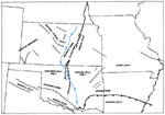
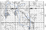
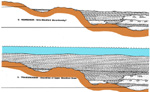
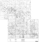
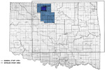 Figure 1--Index
map of Oklahoma, exclusive of Panhandle, showing area of study.
Figure 1--Index
map of Oklahoma, exclusive of Panhandle, showing area of study.
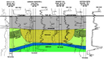
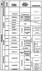 Figure 2--General
stratigraphic correlation chart.
Figure 2--General
stratigraphic correlation chart.
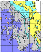
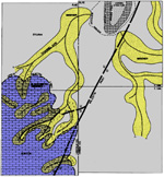
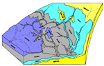
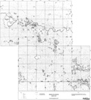
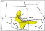 Figure 3--Approximate
distribution of Misener Sandstone.
Figure 3--Approximate
distribution of Misener Sandstone.
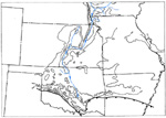 Figure 4--Major pre-Woodford paleodrainage pattern superimposed on Woodford isopach map.
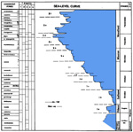
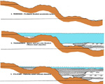
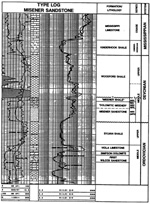 Figure 7--Log of
typical Misener section (Misener Sandstone facies) and bounding strata.
Figure 7--Log of
typical Misener section (Misener Sandstone facies) and bounding strata.
 Figure 8--Log
response showing Misener dolomite facies.
Figure 8--Log
response showing Misener dolomite facies.
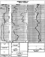 Figure 9--Log
response for Misener Sandstone and dolomite in karst profile.
Figure 9--Log
response for Misener Sandstone and dolomite in karst profile.
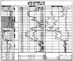 Figure 10--Log
response for Misener shale facies.
Figure 10--Log
response for Misener shale facies.
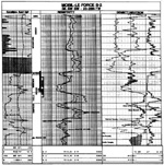 Figure 11--Log
response for phosphatic, illitic, Misener Sandstone.
Figure 11--Log
response for phosphatic, illitic, Misener Sandstone.
Click here for sequence of diagrams.
Click here for sequence of models.
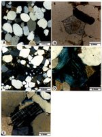
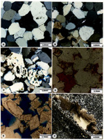
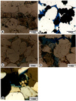
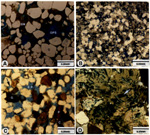
Table 1--Investigations of Misener (Sycamore) Sandstone.
 Map
A-1--Pre-Woodford subcrop map.
Map
A-1--Pre-Woodford subcrop map.
 Map
A-2--Woodford/Misener isopach map
Map
A-2--Woodford/Misener isopach map
 Map A-3--Net
sand, Misener Sandstone
Map A-3--Net
sand, Misener Sandstone

General Setting and Nomenclature
Woodford Shale/Misener Sandstone
Post-Woodford Strata--Mississippian Limestone
Quartz, Dolomite, Phosphates, Detrital Matrix, Other Constituents
Diagenetic Constituents and Features
Silica, Carbonates, Calcite, Dolomite, Clay Minerals, Pyrite, Anhydrite,
Characteristics of Misener Sandstone
Appendix A: Comments Accompanying Maps
Sandstone Distribution--Misener Net Sandstone
Appendix B: Core Description, analysis, and interpretation: Examples
Mobil LeForce No. B-2, 23-26N-7W
TXO Sullivan No. H-4, 34-26N-7W
The area for detailed study of the Middle-Upper Devonian Misener Sandstone is north-central Oklahoma (from westernmost Payne County to northeastern Alfalfa county) (Fig. 1.). The study includes detailed petrography of cores, well-cuttings samples, and outcrop, with calibration of rock parameters to log signatures, along with detailed mapping of sandstone distribution.
Investigations of Misener Sandstone and its equivalent on outcrop, Sylamore Sandstone, began more than 100 years ago. The name was recorded apparently some 75 years ago (Amsden and Klapper, 1972). Most of the previous studies are listed in Table 1.
General Setting and Nomenclature
The Misener Sandstone, which is Middle to Late Devonian in age, is associated with one of the most prominent unconformities developed in Oklahoma. It is associated also with one of the most prominent transgressive sequences, represented by the organic-rich Woodford Shale.
In terms of overall depositional setting for the Misener, Oklahoma during the Devonian was characterized by three major tectonosedimentologic settings: (1) the aulacogen of Southern Oklahoma, which was in a subsidence stage (as opposed to an earlier rifting and a later deformation stage), (2) continental marginal basin in the area of the Ouachita system, and (3) craton-shelf in the areas north of other two regimes.
The subsidence stage of the aulacogen is represented by sedimentary rocks that are substantially thicker than equivalent rocks on the adjacent craton. Upper Cambrian-Devonian sediments are seven times thicker in Southern Oklahoma than their cratonic counterparts. These rocks are predominantly carbonate with some well sorted quartz sands. Abundant fauna, algal structures, and other sedimentary structures suggest that water depths were generally shallow enough for light to penetrate.
Chert formed in the Ouachita system during the Devonian, as part of the sediments in a starved basinal area that, during Ordovician-Devonian, was the depositional setting for black shale and quartzose sandstone, in addition to chert.
The Ordovician-Devonian of the cratonic areas is characterized by relatively thin marine-shelf deposits and a number of unconformities.
Pre-Misener/Woodford Strata (Fig. 2.)
The Middle-Upper Ordovician Simpson Group, subjacent to the Misener in local areas in Northern Oklahoma, is as much as 600 ft thick on the craton and as much as 3000 ft in the aulacogen. In the latter it contains five formations, each with a basal sandstone and overlying carbonate and shale. The Simpson basin was elongated northwestward, with a broad gentle slope on the north and a steeper slope on the south and against the Texas arch (Huffman, 1959).
The Upper Ordovician Viola Limestone usually overlies the Simpson Group unconformably and has an areal distribution similar to the maximum extent of the Simpson. It is predominantly a dense, fine-grained, cherty limestone, with a coarsely crystalline fossiliferous unit near the top and a middle argillaceous unit (Huffman, 1959). The Viola reaches a maximum thickness of 1000 ft in the axis of the aulacogen and thins to 100 ft on the craton (Adler, 1971).
This Upper Ordovician unit is a brown, fissile, graptolitic shale that grades upward into a green claystone with varying amounts of carbonate (Amsden, 1975). It is distinctive in position (between the Viola and Hunton carbonates) and in lithology. The Sylvan is 100 to 350 ft thick in the outcrop area of the Arbuckle Mountains - Criner Hills and less than 100 ft thick in much of the stable area where the Hunton is present. The contact with the overlying Hunton (Chimneyhill) is generally sharp and is thought by Amsden (1975) to show low relief.
The Hunton Group is distinctive because of its carbonate lithologies and position between the Sylvan Shale and Woodford Shale. Associated with the pre-Woodford unconformity is the irregularly developed Misener Sandstone, which in some cases may be dolomitic and/or may be represented as an equivalent silty, sandy dolomite and cherty, silty limestone / dolomite breccia with variable development of shale interbeds.
On outcrop in the Arbuckle Mountains and Criner Hills, the maximum thickness of Hunton strata is 450 ft. The thickness varies significantly; some of the variations reflect intra-Hunton and post-Hunton/pre-Woodford erosion. Seven formations comprise the Hunton Group in the Arbuckle Mountains and Criner Hills--Frisco, Bois d'Arc, Haragan, Henryhouse, Clarita, Cochrane, and Keel, in descending order.
Based on paleontology, Amsden (1975) recognized upper Lower Devonian strata (the thin Turkey Creek Limestone) locally in southern Oklahoma (Marshall County), where it overlies Sylvan Shale. Approximately equivalent units include the Sallisaw Formation in eastern Oklahoma and unnamed limestones in a Kingfisher County well. All of these units, which are considered post-Frisco, overlie an unconformity. In the Kingfisher County well, the section consists of fossiliferous dolomitic limestone and oolitic limestone, 22 ft thick.
Woodford Shale/Misener Sandstone (Fig. 2)
The western limit of the Woodford Shale is in the Texas Panhandle, and a thin Woodford Shale extends northward into Kansas. Maximum thickness occurs near the southern edge of the asymmetric Anadarko Basin and is reported to be in excess of 600 feet (McDaniel, 1959; Jones, 1960; Huffman, 1959), but Amsden (1975) reports only 400 feet.
The Woodford Formation unconformably overlies Ordovician to Lower Devonian strata. Hunton strata are absent on the craton in northernmost and northeastern Oklahoma, locally in southern Oklahoma, and on part of the eastern margin of the Anadarko Basin, where stream erosion was responsible for as much as 300 ft of relief (Amsden, 1975). Where developed, the Misener Sandstone may be regarded as lowermost Woodford. The overall paleoslope was apparently eastward-to-southeastward during its deposition. The Misener shows a highly irregular pattern of distribution; it commonly does not exceed 20 ft in thickness. It may range from a sandy dolomite to dolomitic sandstone, with well rounded sand grains, which were probably derived from the Simpson or equivalents. Angular quartz siltstone and dolomite with argillaceous chert occur in the southern part of the Anadarko Basin at the same stratigraphic position.
The Woodford Shale is a dark gray - black shale throughout its areal extent. The lower part is commonly siliceous with phosphate nodules/lenses and local thin beds of chert. The more siliceous facies of the Woodford near the Ouachita foldbelt have produced hydrocarbons mainly from fracture porosity, and the shales are generally considered to be good source rocks.
Post-Woodford Strata--Mississippian Limestones
The overlying Kinderhookian Series reportedly has a maximum thickness of 200 ft near the axis of the Anadarko Basin and thins shelfward by both onlap and truncation. Locally, a basal sandstone may be present; it consists of rounded quartz sand with weathered chert grains in a dolomite matrix. Typically, Kinderhookian strata consist of green to gray pyritic shales interbedded with oolitic limestones.
The Misener Sandstone is present primarily in north-central and northeastern Oklahoma and central Kansas (Fig. 3). In north-central Arkansas the Misener equivalent Sylamore Sandstone is generally present as thin but extensive sheet sandstones.
The Misener is typically distributed as: (1) sheet sands, (2) isolated pods related to thick Woodford and/or thin Sylvan, and (3) isolated pods related to the Hunton.
The sheet sands range in thickness from 2 to 15 ft and are usually distributed in eastern Oklahoma and in northern Arkansas. These sheet sands appear to have been deposited on and along the margin of the Ozark Uplift.
The isolated pods related to the Woodford and/or the Sylvan are usually best developed along or near the Sylvan subcrop. The pods range in thickness from 5 to 60 ft and commonly are present unconformably on the Sylvan and/or Viola, and locally on Simpson.
Thin isolated pods are commonly developed on the Hunton and are usually related to paleokarst. These Misener zones are also present in southern Oklahoma, but they are usually too thin to be significant.
The only other occurrence of Misener is in enlarged fracture fillings within the Hunton. These features, or "megavugs," most commonly observed in the Arkoma Basin, are related to collapse breccia in a karst terrain.
Two major unconformities are present within the Devonian. The post-Frisco/pre-Woodford unconformity is generally thought to be the most significant because it is considered to be related to most Hunton erosional features and because the obvious change in lithology is from shallow-marine carbonates to deeper marine anoxic shales. Findings from Masera's Hunton Study of the Anadarko Basin indicate that the dominant unconformity is the pre-Frisco/post-Bois d'Arc unconformity. Evidence is represented by the nature of the contact between the Frisco and the underlying Hunton strata.
It is probable that the strong drainage-pattern on the Hunton surface as well as that on the Sylvan, Viola, and Simpson subcrops developed during the pre-Frisco unconformity and was later rejuvenated by the pre-Woodford erosion (Fig. 4).
In most of the study area, where no Frisco is present, the pre-Frisco and pre-Woodford unconformity surfaces are the same; however, it is thought that little or no Misener was deposited until after the pre-Woodford unconformity was developed.
An intra-Woodford unconformity is indicated by both petrography and correlation. Petrographic analysis reveals that the Misener may be an overall slightly fining-upward sequence, which is dominated by normal-marine phosphatic sandstones at the base and shallow-marine carbonates at the top. Admittedly this same sequence could develop by other processes, such as change in source; however, correlations of the Woodford, especially in the south, show that it may be divided into two sequences. Each is characterized by a lower anoxic, resistive shale and a carbonate, or shale, at the top. The lowermost of these units is associated with the Misener section (Fig. 5).
Evidence also exists for minor intra-Misener unconformity, or disconformity, that divides the Misener Sandstone below from the Misener dolomite above.
The Misener Sandstone, in relation to eustatic sea-level fluctuations, may be shown to represent the initial part of a transgressive-regressive megacycle that began in middle Givetian (Middle Devonian) (Fig. 6) (Johnson et. al., 1985; Mankin, 1987).
The previous megacycle, from Lochkovian/Pragian (Early Devonian) to middle Givetian, was characterized by overall rise in sea level. The beginning of this cycle corresponds to the initiation of Frisco deposition in Oklahoma and to the earliest phase of the transgression over the unconformity (or over the top of shallowing-upward marine beds) that marks the top of the Lochkovian in North America (and the top of Sloss' Tippecanoe Sequence) (Johnson et. al., 1985). The unconformity at the top of the Frisco represents the end of the oldest transgressive-regressive cycle in the Early Devonian-Middle Devonian megacycle (I of Johnson et al., 1985; Fig. 6).
The significance of these relationships is: (1) the Misener and Woodford are parts of the same megacycle and (2) the Frisco is part of a separate megacycle in relation to older units of the Hunton.
As noted above, the Woodford can be divided into upper and lower shallowing-upward sequences. The lowermost sequence contains the Misener, as incised-valley fill, which can further be divided from bottom to top into (a) sandstone, phosphatic in lowermost part, (b) shale, (c) mixed sandstone and dolomite and (d) dolomite. This sequence is described in greater detail below
Due to the discontinuous nature of the Misener Sandstone, it cannot be correlated regionally except by its lithology and relationships to Woodford and other strata. The Misener Sandstone and shale section appear to represent early Woodford deposition; there apparently was partial erosion before deposition of the remainder of the Woodford.
The Misener Sandstone is a dolomitic sandstone that can usually be recognized by log examination and correlated from well to well where it exists. The sequence of sandstone to shale to dolomite represents a normal complete sequence with exception of the "Misener shale," which may be present throughout sections of the Misener.
On a typical Misener well log the sandstone is recognized by its clean gamma-ray and well developed SP response (Fig. 7). The sandstone has a resistivity response that is characteristic of a clean sandstone; i.e., low resistivity where water-saturated and high where oil-saturated. In addition to the log response, the Misener is easily recognized by its relationship to surrounding strata, which are usually limestone or shale (Fig. 7). The “Misener shale” is herein defined as a shale which is genetically equivalent to the Misener Sandstone but which has a log response and petrography similar to the Woodford Shale.
Several variations from typical Misener Sandstone lithology are: sandy dolomite, dolomite, shaly sandstone, and a very unusual extremely illitic, phosphatic sandstone.
Recognition of the dolomitic facies is facilitated by the use of porosity logs, especially the neutron-density log. Figure 8 shows log response of the Misener dolomitic facies. The Misener dolomite usually present near the top of a sandstone section generally has a less developed SP curve and less porosity than the sandstone. Where the dolomite is developed superjacent to the Hunton or Viola limestones, it is often difficult to differentiate (Fig. 9). In many cases the Misener dolomite in contact with the Hunton is actually a karst deposit.
Figure 10 shows an example of the Misener shaly facies. Although this shale is commonly interlaminated with the sandstones, it is usually located near the top of the Misener section and commonly separates the Misener sand and the Misener dolomite (Fig. 8). The Misener shale is very similar to the Woodford, based on correlation to the south, as well as core and sample analysis. It is probably part of the lower Woodford, as is the entire Misener section. The Misener shale, usually 5-20 ft thick, separates sand or dolomite packages with rather sharp boundaries.
Perhaps the most unusual variation from the type Misener log response is represented by the log in the Mobil LeForce 1 (Fig. 11). Based on log response there appears to be only 20 feet of sandstone in the well with 15 ft of shale below the sandstone and above the underlying Viola Limestone. Core analysis, however, shows that the 15 ft of shale is actually sand with 19% porosity and over 1 darcy of permeability. It is in fact the best quality sandstone in the wellbore and represents the producing zone. The only evidence that this is sand, based on the log character, is the mud cake indicated by the caliper and the slight cross-over on the neutron-density; otherwise it appears to be shale. The log response is most likely caused by the high percentage of phosphate, altered illite, and pyrite in the lower portion of the sand.
Correlation from well to well is usually difficult outside of local field areas due to lack of continuity of the sand bodies, resulting from the nature of the depositional surface and erosion associated with relative sea-level changes. Within local areas the Misener can be correlated by using facies relationships and recognition of minor disconformities.
The study area in north-central Oklahoma includes an area along and west of the Nemaha Ridge (Fig. 12). Strata generally dip south-southwest west of the Nemaha unless affected by local structures or faults and folds related to the Nemaha system.
Although local structure does not appear to have affected deposition of the Misener directly, it does appear to have controlled it indirectly and regionally by controlling the paleodrainage patterns on the pre-Woodford surface (Fig. 12).
The Nemaha Ridge is a major north-south structural system, that extends from the Arbuckle Mountains in the south, northward through Central Oklahoma into Kansas (Fig. 12). It is a major strike-slip fault system composed of many major structural features, including the Oklahoma City, Garber, Lucien, and Hunter structures.
The Nemaha Ridge has been an active structural feature since Early Paleozoic, although most of the movement occurred during the Pennsylvanian, with the Wichita and Arbuckle orogenies.
The Nemaha Ridge does appear to have been active during Devonian time, as is evident by the fact that the Frisco was deposited on a structural paleohigh and around what is now the Oklahoma City Field. Additional evidence for structural activity is the control of pre-Woodford/Frisco paleodrainage by Nemaha-Ridge-related faulting. An examination of the overall trend of the pre-Woodford subcrop patterns shows the overall northwest-southeast trend that extends into the Arkoma Basin (Fig. 13). Examination of the trend shows that the "Sylvan Valley" extends southward for over 20 miles along the Nemaha Ridge north of its southeastward trend into the Arkoma Basin.
The Hunter Field (T24N, R4W and 5W, Garfield County) is a good example of structural influence. The Woodford isopach map (Fig. 14) shows a change in direction of the paleodrainage around the Hunter structure following the north-south Nemaha outlet to the south. The West Kremlin Field, immediately west of the Hunter structure, also shows evidence of paleostructural influence on Misener distribution (Fig. 15).
To the east-southeast of the detailed study area, well documented control of Misener distribution was exerted by the Cushing Ridge, in parts of Creek and Lincoln counties (Fig. 16). At the time of Misener deposition the area of the Cushing Field was undergoing uplift and erosion, with Simpson sands exposed along the axis of the Ridge. Bauernfeind (1980) shows that the Misener distribution, petrology, and underlying paleogeography indicate Misener-age streams or river channels drained the southern flanks of the Cushing Ridge (Fig. 16). Near the updip limit of the Hunton subcrop, the Misener contains dolomite and glauconite, in contrast to clean, well sorted sands to the north. Misener distribution in this area also tends to lose its channel-like geometry. These data suggest reworking of Misener channel sands in a marine-like environment. Local Misener distribution resulted from the presence of two distinct, but interrelated, depositional environments--and apparently one local source. Similar examples of local Misener sources exist in areas along the Nemaha Ridge, although they are not as well documented as the Cushing example.
The depositional environment of the Misener Sandstone in north-central Oklahoma is difficult to determine due to the unusual association of lithologies and facies. Reliable determination of environment and geometry can only be made by understanding the overall geologic setting. The account presented here of the features and interpretations that relate to Misener deposition is divided into five parts: unconformities, paleogeography, source area, petrography, and stratigraphy.
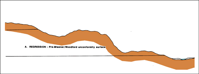
As noted heretofore, development of two unconformities, pre-Frisco and pre-Woodford, punctuated Hunton deposition. Although the latter unconformity is most commonly associated with the Misener, the development of both these unconformities appears to have controlled Misener deposition. The Misener may, in fact, represent an overall shallowing-upward sequence bounded by an intra-Woodford unconformity or disconformity (Fig. 17).
Although seldom discussed in the literature, the pre-Frisco unconformity, based on regional stratigraphy, appears to represent a period of significant erosion. The top of the pre-Frisco Hunton section is defined by an angular unconformity which is best developed basinward of the Hunton hingeline.
However, over most of the study area it is impossible to differentiate between the two unconformities; yet, the Frisco truncates many of the pre-Frisco Hunton units--from the Chimneyhill to the Bois d'Arc. This relationship strongly suggests that much of the Hunton was eroded prior to Frisco deposition. Additional evidence for the magnitude of the pre-Frisco unconformity is that during the Devonian relative sea level apparently was lowest prior to Frisco deposition (Fig. 6).
Pre-Woodford Unconformity (Fig. 13; Map A-1)
After deposition of the Frisco another lowstand developed, and the Hunton was eroded to near its present-day subcrop configuration (Fig.13). Although the actual duration of the lowstand is unclear, it may have been a relatively short time, based on the absence of dolomite and karst in the Frisco. A major transgression followed pre-Woodford erosion during which Misener, as well as the Woodford, was deposited.
This "Woodford transgression" actually consisted of two transgressive/regressive cycles (Fig. 17), the first of which was relatively minor but is represented by the Misener; it is herein called the "lower Woodford cycle." Based on conodonts, Amsden and Klapper (1972) conclude that Woodford deposition in southern Oklahoma, at least in part, was contemporaneous with Misener deposition in north-central Oklahoma.
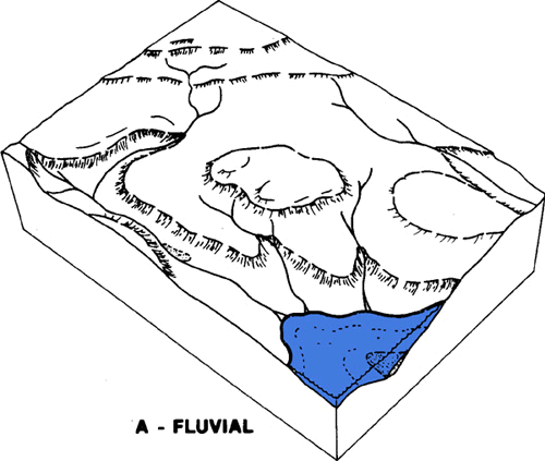
The top of the Hunton surface was etched mostly by fluvial erosion during the two periods represented by the unconformities described above. As evidenced by the sparsity of sand in pre-Woodford channelized deposits and the absence of nonmarine Misener sand, the fluvial systems apparently carried very little sand. The Woodford Misener isopach map shows an overall dendritic stream pattern, modified by faulting and fracturing along the north-south Nemaha Ridge (Fig. 13, Map A-2).
The major paleostream system in the study area was located along the Sylvan Shale subcrop ("Sylvan Subcrop Valley”). Most of the well developed Misener sandstone production is located along this system. Regionally, it represents a relatively short section of a major drainage system that extended northward into Kansas (Fig. 12), and perhaps as far as Canada, and may have been controlled by faulting and fracturing along the Mid-Continent Rift System.
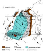
A diagrammatic paleogeographic depositional model (Fig. 18) of the study area depicting the pre-Misener/Woodford unconformity shows that the drowned Sylvan Subcrop Valley probably was the most likely setting for Misener deposition. In overall geometry, the area during that time may have been similar to the present Baltic Sea. Misener deposition generally represents temporal disturbances in the stratified watermass, with associated anoxic conditions, in which the Woodford was deposited. Paleogeographic reconstruction of the latest Devonian time (Famennian) places Oklahoma within 5o of the Famennian equator (Fig. 19). In this region the humid climate permitted salinity stratification of the water column that led to the anoxia of its bottom waters (Parrish, 1982).
The Sylvan Subcrop Valley was restricted to the southwest by the Hunton subcrop paleohigh and to a lesser extent on the northwest by the Viola-Simpson subcrop paleohigh. The latter was not as prominent as the former, as indicated by an increase in Woodford thickness from the Hunton to the Simpson subcrop, with only a slightly additional increase in thickness across the valley.
The Misener sand was probably derived from erosion of the Simpson Sandstone and/or equivalents (Fig. 3). Because of the fluvial-formed surface on which the Misener was deposited, it seems logical to assume that the Misener sand was derived from Simpson subcrops to the north. However, due to the marine nature of the Misener sand and due to the lack of Misener sand along the Sylvan Subcrop Valley north of the Kremlin area, it is possible that the sand was derived from the Ozark Dome area, where there is an abundance of both Simpson and Misener (Sylamore) sand. This is supported by the poorly developed Viola-Simpson subcrop paleohigh that allowed sand movement from east to west by marine currents.
An alternative explanation is that fluvial sands derived from adjacent Simpson subcrops northward and into Kansas were eroded and redeposited during the "lower Woodford cycle." Also, some of the lenticularity (or pod-like nature) of the Misener may be due to subsequent, but intra-Woodford, erosion.
The Misener section contains sandstones, shales, and dolomites. Thick sandstones are composed of two or more sand sequences separated by scour surfaces and/or "Woodford-like" shales.
Compositionally, the sands are primarily quartz, with small but significant amounts of phosphate, glauconite, and fossil fragments. Illite is the most common clay mineral, and both siliceous and carbonate cements are present.
The upper part of the Misener tends to be dolomitic, and in places it is a sandy dolomite. This relation indicates that the Misener formed in a mixed terrigenous-carbonate regime, and it also suggests that the upper Misener, which was deposited when terrigenous input was sharply limited, may represent a shallowing-upward sequence. Within some of the Misener fields the "edge wells" contain thin Misener sands that are relatively dolomitic and pyritic. The Kremlin area shows the best development of upper dolomite/shaly Misener and lower, sandy, more porous Misener.
Although the general stratigraphy of the Misener section is relatively simple, the internal stratigraphic relationships in the Misener tend to be complex. In several fields, reservoir heterogeneity, including lateral changes in lithofacies, is reflected in the production data.
In the study area, the Misener is commonly underlain by the Sylvan Shale or Viola Limestone and, to a lesser extent, by the Hunton Limestone and Simpson Dolomite. The Misener section is overlain everywhere by the Woodford Shale.
The Misener, which appears to be genetically related to the Woodford Shale, corresponds to the "lower Woodford cycle;" it overlies and interfingers with Woodford-like "Misener shales" (Figs. 5, 17).
Local markers within the Misener correspond to minor sequence boundaries. Subregionally, correlation of units/markers within the Misener are possible only in the southern part of the study area, where the Misener and Woodford are relatively thick (Fig. 5).
General Statement
The composition of Misener sandstones is rather simple but unusual. Changes in the proportions of various constituents have resulted in noticeable lithologic heterogeneity, which is very significant in the interpretation of depositional environments. In addition, this variability has been a dominant factor in diagenesis and development of reservoirs. Although, quartz and dolomite are the major constituents, the depositional setting of the Misener was closely related to the Woodford shale, as indicated by phosphatic components, glauconite, and pyrite.
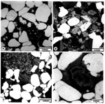
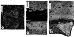
Twenty-three cores were examined in detail for this study. A petrolog, depicting depositional as well as compositional parameters, was prepared as part of describing each core. Approximately 200 thin-sections were selected from the cores for microscopic investigation of porosity and textural and compositional relationships (Figs. 21, 22, 23, and 24). More than 70 of these thin sections were selected for point counts in order to determine variability, especially in dolomite, quartz, phosphate, and detrital matrix. Selected scanning-electron-microscopy (SEM) analysis provided verification of composition and fabric (Fig. 25). Cathodoluminescence of selected dolomitic samples aided in distinguishing zonation of dolomite rhombs.
Constituents are divided into detrital and diagenetic elements, with dolomite and matrix being particularly important because of the problem of genesis of each.
Quartz
Quartz, the most common siliceous component in Misener sandstones, varies in abundance from less than 1% in the dolomitic facies to more than 90% in the quartzose facies. It ranges in grain size from very fine-grained (0.1mm) to coarse-grained (0.55mm); fine grain is the average size. Grains are subrounded to rounded and are relatively well sorted. Monocrystalline grains are the dominant type (Fig. 21A). . In relatively "clean" sandstones, most quartz grain are rimmed with quartz overgrowths, while corroded grain outlines are present in "dirtier" units, with up to 10% matrix.
Most of the dolomite in the Misener is diagenetic in origin, as noted below. However, some petrographic evidence suggests that minor amounts of the dolomite may be of detrital origin. Considered to be detrital are cores of certain dolomite rhombs that in a few thin-sections appear to have somewhat rounded and relatively cloudy cores, as compared to the limpid euhedral outer rims (Fig. 21B). The source(s) for these dolomites may have been the Hunton, Simpson, or Arbuckle.
Phosphatic material in Misener sandstones and dolomite is of detrital and diagenetic origin; it is generally concentrated in the sandstone facies. The detrital phosphates include phosphatized skeletal fragments of wide varieties, including Devonian conodonts; the clast size ranging from silt to pebble are dominantly sand size. They are basically rounded, brown collophane and apatite, to a lesser extent. Phosphates vary in abundance from a trace to approximately 10%. The Woodford shale is considered to be the major source; however, some material was undoubtedly derived from the Viola, which contains phosphatic nodules/bands. Although upwelling is thought by many authors to be the necessary conditions for phosphate precipitation, Pevear (1966) suggests that some phosphorites may form in estuaries, where conditions are favorable for replacement of carbonate fragments by phosphate.
Detrital matrix is relatively common in Misener sandstones--from less than 1% to approximately 45% (Fig. 21C). Abundant detrital matrix generally reflects relatively low-energy environments, some of which are characterized by extensive bioturbation. The matrix varies from silt- to clay-dominant sediment. The latter type usually shows signs of neomorphism.
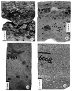
A wireline log of a productive interval with illite as the dominant clay mineral in detrital matrix (5990 to 6002 ft in Mobil LeForce No. B-2, Fig. 11) shows a distinctly low resistivity and relatively high gamma-ray response. Some of the illite shows signs of neomorphism, and it may be the precursor to some of the diagenetic illite (Fig. 21D).
K-feldspar and plagioclase occur in trace quantities (Fig. 21E). Chert and other rock fragments compose less than 2% of the total rock. Heavy minerals, such as zircon, tourmaline, and rutile, are also present in trace amounts.
Diagenetic Constituents and Features
Diagenetic reactions usually begin shortly after deposition and continue during burial history and tectonic episodes. The resulting very diversified products, including cements and neomorphic elements, exhibit a complex lithologic heterogeneity that may be directly related to depositional facies.
Silica as syntaxial quartz overgrowth is very common in the cleaner facies of Misener sandstones. Overgrowths are usually separated from detrital grains by a very thin, incomplete, clayey rim composed of illite (Fig. 22A). Silica cementation may be very extensive, resulting in some cases in complete occlusion of pore space. On the other hand, the various "dirty" sandstones commonly show minimal silica overgrowth. In these cases, coatings of the grains may have prevented nucleation of silica. Chert, which composes up to 2% of the total rock, occurs as pore-filling and as replacement of certain detrital constituents and dolomite (Fig. 22B). Occasionally fibrous silica coats quartz grains; chalcedony also occurs in minor amounts. In several thin-sections, equigranular quartz replaces early anhydrite (Fig. 22C), suggesting the presence of hypersaline solutions that may have migrated downdip to form nodules in the sandstones.
Carbonate mineralogy and texture present a complicated genetic problem, although the mineral assemblage consists only of calcite and dolomite.
Calcite. Calcite is a minor constituent of the total carbonate fraction. Although an early phase of calcite is recognized, a late phase is the conspicuous one observed in several cores. This late calcite cement is commonly poikilotopic (Fig. 22D), with replacement and displacement textures and in association with incipient dedolomitization.
Dolomite. Dolomite is one of the most abundant and enigmatic constituents of Misener sandstones. Most of the dolomite rhombs are without a distinct, well defined core, and many of these show zoned structure (Fig. 22E). Another type of dolomite, the xenotopic C (cement) (Gregg and Sibley, 1984), with sweeping extinction but without distinct euhedral outlines, probably formed during maximum burial (Fig. 22F). The concept of dual (or mixed) phases of clastics and carbonates is very significant in estimating depositional environment as well as understanding the lithologic diversity, with a sandstone-dominated phase and a dolomite-dominated phase. The spatial boundaries in the Misener between these two are transitional rather than sharp.
The composition of these dolomites may vary from regular-ordered dolomite to ferroan type. The majority of the dolomite rhombs are zoned, suggesting incremental accretion of dolomite during diagenesis; a number indicate iron-rich episodes (Fig. 23A). Finally, some of the dolomite studied show evidence of dedolomitization (Fig. 22D). Portions of some rhombs were replaced by calcite. The timing of this event appears to coincide with the late calcite cement phase.
Authigenic clay minerals in the Misener sandstones are less abundant than the detrital clays. Most of the diagenetic clay minerals are neomorphic products of the detrital precursor.
Illite. This is the most abundant diagenetic clay mineral in the sandstones. It occurs in two varieties: (1) neomorphic matrix in which clay particles show signs of recrystallization due to reaction between formation fluid and matrix (Fig. 21D), and (2) a distinctly crystalline variety that occurs as pore lining and filling. As noted previously, illite may have had a significant effect on the resistivity and gamma-ray log signatures of Misener Sandstone in the interval from 5990 to 6002 ft in Mobil LeForce No. B-2 (Fig. 11).
Chlorite. Chlorite also occurs as neomorphic matrix and distinct crystals that line pores. It is noticeably less abundant than illite.
Kaolinite. In a few of the thin-sections, authigenic kaolinite occurs sporadically as pore filling.
Glauconite. Glauconite, which compositionally ranges from illite to mixed-layer illite-smectite, is relatively common in Misener sandstones. It varies from a trace to up to 5%. Glauconite pellets are characterized by their distinct green color. They usually form at the site of deposition under a specific geochemical condition that includes relatively "clean" marine conditions. Some glauconite pellets near stylolite zones in the Misener have undergone compaction, resulting in ductile deformation of these pellets and formation of a pseudomatrix. The brown glauconite that was observed represents limonitic stain resulting from oxidation of the ferrous iron components in the glauconite structure.
Pyrite is a minor cement in the sandstones. Morphology varies from poikilotopic texture, as pore filling, to framboidal, as partial and/or complete replacement of grains, such as glauconite and collophane (Fig. 23B). A crystalline phase with euhedral outline is also present. An early phase of pyrite is present along stylolites, while late pyrite cement may be genetically related to hydrocarbon migration. In the interval from 5990 to 6002 ft, in Mobil LeForce No. B-2, pyrite cement is very pervasive as a major cement that affects the resistivity log signature.
A nodule of anhydrite is present at 5823.5 ft in Deck Oil Biby No. 2 (36-27N-8W). Anhydrite also occurs as small, isolated laths in dolomite units, generally in the upper part of the Misener. However, most of the anhydrite observed seems to occur as floating remnants in quartz grains that appear to have replaced anhydrite nodules (Fig. 22C). Although this minor feature may occur at any level within the Misener, it is more common to the lower sand-rich interval. The presence of anhydrite may suggest downward migration of hypersaline brines and/or a local, temporal tidal flat, from which the anhydrite may have been transported into the Misener sandstone facies.
Phosphate cement is present in minor amounts in the sandstones. It may be considered as remobilized detrital phosphatic material. The major occurrence is as nodules and coatings on some grains.
Both primary intergranular porosity and secondary porosity are present in Misener sandstones.
Primary porosity (e.g., complete preservation of intergranular porosity or slight modification of original porosity by minor cementation) is as much as 7%, with an average of 2% (Figs. 23C, 25A). Cleaner sandstones are commonly cemented with quartz overgrowths; however, in some cases remnant primary porosity is preserved. The pure dolomite facies is also highly cemented. Units with minor matrix show somewhat greater tendencies to preserve the original porosity.
This porosity type is very common in Misener sandstones. The development of this type is directly related to dissolution of framework constituents, matrix, and cements (Figs. 23D, 24, 25B-C). It appears that remnant primary porosity is very important in the evolution of secondary porosity because some of the original pore was required for movement of pore fluids in order to initiate various dissolution reactions.
Siliceous components and, to a lesser extent, dolomite show evidence of partial to complete dissolution in generation of secondary porosity. In addition, some of the phosphatic constituents also exhibit signs of dissolution. Siliceous components are represented by detrital matrix, glauconite, chert, quartz, and feldspars (Figs. 21E, 23D, 25B). Illitic detrital matrix may show extensive leaching, resulting in additional porosity measuring up to 10% (Figs. 24A, 25B). Glauconite also shows evidence of dissolution, with porosity generation of less than 2% (Fig. 24C). Chert commonly shows some effects of dissolution, which, however, is not very pervasive; it may contribute locally to the porosity. Quartz grains very commonly show some corrosion and partial dissolution, which is probably related to the removal of former grain and matrix. Dolomite dissolution is also common; it may contribute as much as 3% porosity in some of the sandstones (Figs. 23E, 24B, 26C).
The mineral composition of detrital matrix, glauconite, dolomite, and phosphatic material suggests that acidic solutions had to be present in order for dissolution to take place. These acidic or hydrogen-ion-bearing fluids may have attained their hydrogen ions from maturation of Woodford organic matter. It is also possible to speculate that some of diagenetic fluids may have originated from the shale during compaction and thermal transformation of these shales. On the other hand, chert and quartz need a slightly alkaline solution to be corroded or partially dissolved. The alkaline solution may have evolved from the total consumption of hydrogen ions during the previous reactions. Textural evidence of quartz corrosion tends to support the above conclusion, for corrosion is present only in areas where detrital matrix remnants still exist.
Enlarged intergranular porosity (EIP) and oversized pore space (OPS) are the major morphologies observed (Figs. 23, 24). Elongated pore space, moldic porosity, and other morphologies occur but less commonly. Although only one of these types may be present in some thin-sections, a combination of these morphologies is generally present in reservoirs with good porosity. EIP occurs mainly in areas with dissolved detrital matrix. OPS represents a more complex dissolution process, affecting a combination of grains and/or matrix. Elongated pores are usually present along stylolitic surfaces, whereas the moldic type may form as a result of dissolution of a single grain and/or crystal, clast, nodule, or peloid (Fig. 24A).
The diagenetic history of the Misener, summarized by the paragenetic sequence in Figure 26, is rather complex because of multiple depositional systems and spatial variation in lithology. The quartz-rich facies may have followed a different diagenetic path compared to dolomitic-rich facies. Quartz overgrowth is the major early cement; however, an early calcite cement may have preceded the quartz overgrowth.
Diagenetic illite was formed largely by neomorphic processes, but highly crystalline authigenic illite also occurs. Chert and, to a lesser extent, chalcedony were precipitated in pore space; in few instances they replaced earlier minerals, such as anhydrite, dolomite, and framework elements. A late phase of calcite precipitation was prominent locally--at the base of the sandstone and at the oil-water contact, in particular. The calcitic-rich fluids may have played a role in the dedolomitization observed. A minor stage of diagenetic chlorite was followed by kaolinite, which formed as pore filling.
There is evidence that hydrocarbon entrapment restricted destructive diagenetic processes. Pyrite may be genetically related to maturation and early migration of hydrocarbons into the Misener reservoirs.
A diagenetic enigma presented by the dolomite is due mainly to the formation of different dolomite species at different times. The Upper Misener dolomite may have been deposited as calcite and/or aragonite and subsequently dolomitized by one or more of the processes, such as dense hypersaline brines migrating downdip and by mixed fresh and saline waters (Fig. 27). The euhedral dolomite most likely formed as the result of fresh-water mixing conditions that formed zoned, ferroan dolomite rhombs (Fig. 28). When the Misener attained a certain burial depth, the xenotopic C phase formed.
Characteristics of Misener Sandstone
The following are Misener characteristics, along with interpretations, that relate to depositional environment(s) and distribution of reservoir within it:
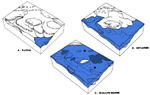
1. The Misener was deposited on a major unconformity. In some cases Woodford-like shale overlies that surface (Fig. 20A) and occurs within sand bodies, which contain glauconite and phosphate. The Misener, which therefore is genetically related to the lower part of the Woodford, developed as a local facies during overall deposition of euxinic shale from a stratified watermass.
2. Prior to Misener deposition, a fluvial paleodrainage system was well developed on the pre-Misener surface, especially along the Sylvan subcrop.
3. In the study area, the most significant sand bodies were deposited in the area of Sylvan subcrop; the Misener, which represents an incised valley fill, was deposited in a complex marine system that formed during the early Woodford transgressive/regressive cycle. During the initial transgression, valleys were drowned to form estuaries, in which Misener sand was deposited (Fig. 20B).
4. The Misener was probably sourced from adjacent Simpson subcrops, Simpson subcrops in Kansas, and/or the Ozark Dome. The Misener could even have been sourced from the Appalachian Uplift, but there is not enough evidence to support this hypothesis.
5. All Misener units are shallow marine in origin, based on bioturbation, burrows, phosphate, glauconite, dolomite, and fossil fragments.
6. The Misener formed in a mixed terrigenous-carbonate regime, with carbonate deposition generally following sand deposition. This may have been accompanied by an overall shallowing.
7. During continuation of the transgressive phase, broader areas were inundated to form an embayment, with Misener sand forming tidal ridges or ribbons (Fig. 20C).
8. Tidal flat may have been a common environment for some Misener sand, but evidence (early diagenetic dolomite, scattered anhydrite, and a certain type of mottled sand) is rather sparse.
9. Sand transportation by marine currents from eastern source areas was probably greatest during highstands (Fig. 20C). Some transportation probably also occurred during lowstands by local streams, although these streams probably carried mostly suspended load.
10. Thick sections of Misener are commonly composed of several sequences, separated by scour surfaces and/or "Woodford-like" shales.
11. Pod-like Misener sand bodies probably reflect partial removal during intra-Woodford erosion that possibly preceded or accompanied the second transgression.
12. Subsequent events formed the major transgressive/regressive cycle during which the bulk of the Woodford Shale was deposited.
13. Porosity responsible for development of hydrocarbon reservoir is largely due to secondary porosity--dissolution of framework grains and detrital matrix.
14. The Misener is very similar in many respects to the Lower Morrow sandstones in the northern part of the Anadarko Basin and Atokan Spiro sandstones in the Arkoma Basin. Each, deposited in channel-like settings to form shallow-marine incised valley fill.
Adler, F. J., 1971a, Future petroleum provinces of the Mid-Continent, in Cram, I. H., ed., Future petroleum provinces of the United States--Their geology and potential: AAPG Mem. 15, v. 2, p. 985-1042.
__________, 1971b, Anadarko Basin and central Oklahoma area, in Cram, I. H., ed., Future petroleum provinces of the United States--Their geology and potential: AAPG Mem. 15, v. 2, p. 1061-1070.
Amsden, T. W., 1975, Hunton Group of the Anadarko Basin of Oklahoma: Okla. Geol. Survey Bull. no. 121, 304 p.
__________, 1972, Misener Sandstone (Middle-Upper Devonian), north-central Oklahoma: AAPG Bull., v. 56, p. 2323-2334.
__________, and Klapper, G., 1972, Misener Sandstone (middle Upper Devonian) north-central Oklahoma: AAPG Bull., v. 56, p. 2323-2334.
Aurin, F. L., Clark, G. C., and Troger, E. A., 1921, Notes on the subsurface pre-Pennsylvanian stratigraphy of the north mid-continent fields: AAPG Bull. v. 5, p. 117-153.
Bauernfeind, P. E., 1980, The Misener Sandstone in portions of Lincoln and Creek Counties, Oklahoma: Shale Shaker Digest, v. 30, p. 1-30.
Borden, J. L., and Brandt, R. A., 1941, East Tuskegee Pool, Creek County, Oklahoma, in Stratigraphic Type Oil Fields, A Symposium: p. 436-455.
Busanus, J. W., 1988, Misener strike-valley sandstone reservoir, Grant and Garfield Counties, Oklahoma: TGS Special Publ. no. 3.
Bockhorst, M. F., 1987, Practical method for exploration for Misener sand bodies on Sylvan subcrop in Grant and Garfield Counties, Oklahoma: AAPG Bull. v. 71, no. 8, p. 990.
Caplan, W. M., 1954, Subsurface geology and related oil and gas possibilities of Northeastern Arkansas, Arkansas Resources and Development Commission, Bulletin 20.
Cram, I. H., 1930, Oil and Gas in Oklahoma, Cherokee and Adair Counties: OGS Bull., 40, v. 3, p. 552.
Croneis, C., 1930, Geology of the Arkansas Paleozoic area: Arkansas Geol. Survey Bull. 3, 457 p.
Francis, B. M., and Mansfield, C. F., 1987, Depositional setting and thin section petrology of Misener formation (Devonian) in Northeast Nash and nearby fields, north-central Oklahoma: AAPG Bull., v. 71, no. 8, p. 992.
Francis, B. M., 1988 Petrology and sedimentology of the Devonian Misener formation, north-central Oklahoma: unpublished M.S. Thesis, University of Tulsa.
Freeman, T., and Schumacher, 1969, Qualitative pre-Sylamore (Devonian-Mississippian) physiography delineated by onlapping conodont zones, northern Arkansas: Geol. Soc. Amer. Bull., v. 80, no. 11, p. 2327-2334.
Hass, W. H., and Huddle, J. W., 1965, Late Devonian and Early Mississippian Age of the Woodford shale in Oklahoma, as determined from conodonts: U. S. Geol. Survey Prof. Paper 525-D, p. D125-D132.
Hopkins, T. C., 1893, The St. Clair Marble: Arkansas Geol. Survey Ann. Report., 1890, v. 4, p. 212-222.
Huffman, G. G., 1959, Pre-Desmoinesian isopachous and paleogeologic studies in central and mid-continent region: AAPG Bull., v. 43, p. 2541-2574.
Imbt, W. C., 1941, Zenith Pool, Stafford County, Kansas - An example of stratigraphic trap accumulation, in Stratigraphic Type Oil Fields, A Symposium: p. 139-165.
Johnson, J. G, G. Klapper, and C. A. Sandberg, 1985, Devonian eustatic fluctuations in Euramerica: GSA Bull., v. 96, p. 567-587.
Jones, C. L., 1960, An isopach structural and paleogeologic study of pre-Desmoinesian units in north-central Oklahoma: Shale Shaker, v. 10, p. 9-19.
Jordan, L., 1957, Subsurface stratigraphic names of Oklahoma: Oklahoma Geol. Survey Guidebook 6, 220 p.
Kochick, J. P., 1978, Petroleum geology of the Misener Sandstone in parts of Payne and Lincoln Counties, Oklahoma: unpublished M.S. Thesis, Oklahoma State University, 63 p.
Krumme, G. W., 1969, The geomorphology of the pre-Woodford unconformity surface in the mid-continent and its relation to oil production: Unpublished Research Paper, University of Tulsa.
Kuykendall, Michael D., and Richard D. Fritz, 1993, Misener sandstone: Distribution and relationship to late/post-Hunton unconformities, Northern Shelf, Anadarko Basin," in Hunton Group core workshop and field trip: Oklahoma Geol. Survey Spec.Publ. 93-4, p. 117-134.
Mankin, C. J., Coordinator, 1987, Texas-Oklahoma tectonic region: Correlation of stratigraphic units of North America (COSUNA) project: AAPG.
Mansfield, C. F., Brecker, C. E., 1985, Petrology and porosity of Devonian Misener formation, West Kremlin Field, Garfield County, north-central Oklahoma: AAPG Bull. v. 69, p. 283.
McDaniel, G. A., 1959, Isopachous and paleogeologic studies of southwest Oklahoma: Shale Shaker, v. 10, p. 4-27.
Parrish, J. T., 1982, Upwelling and petroleum source beds, with reference to Paleozoic: AAPG Bull., v. 66, no. 6, 750 p.
Penrose, R. A. F. Jr., 1891, Manganese, its uses, ores, and deposits: Arkansas Geol. Survey Ann. Report., 1890, v. 1, 642 p.
Pittenger, A., 1988, Provenance and depositional environment of the Sylamore Sandstone in Northeastern Oklahoma and Northern Arkansas: Shale Shaker Digest, v. 38, no. 4.
Pogue, P. T., 1987, Misener Sandstone in portions of Grant and Garfield Counties, north-central Oklahoma: unpublished M. S. Thesis, West Virginia University, 57 p.
Rau, H. L. and Ackley, K. A., 1939, Geomorphology and development of the Keokuk Pool, Seminole and Pottawatomie Counties, Oklahoma: AAPG Bull., v. 23, p. 220-245.
Stewart, G. F., and Kochick, J. P., 1978, Association of thickness, Woodford Shale and Misener Sandstone; in: Petroleum geology of the Misener Sandstone in parts of Payne and Lincoln Counties, Oklahoma: unpublished M. S. Thesis, Oklahoma State University, 63 p.
Swanson, V. E., and Landis, E. R., 1962, Geology of a uranium-bearing black shale of Late Devonian age in north-central Arkansas: Arkansas Geol. and Conserv. Comm. Inf. Circ., No. 22, 16 p.
Taff, J. A., 1905, U. S. Geol. Survey, Geol. Atlas, Tahlequah folio (no. 122), p. 3.
Ulrich, E. O., 1911, Geol. Soc. America, v. 22, no. 3, p. 559.
Walker, L. P., 1984, Depositional environments, petrography, and diagenesis of the Middle to Upper Devonian Misener Sandstone in north-central Oklahoma: unpublished M. S. Thesis, Oklahoma State University, 97 p.
Walters, D. L., 1958, The pre-Woodford subcrop and its relationship to an overlying detrital lithofacies in northeast Marshall and southwest Johnson Counties, Oklahoma: unpublished M.S. Thesis, Oklahoma University, 37 p.
White, L. H., and Greene, F. C., 1924, Four horizons below Mississippi Lime: Oil and Gas Journal, v. 23, p. 42, 68.
__________, 1926, Subsurface distribution and correlation of the pre-Chattanooga ("Wilcox" sand) series of northeastern Oklahoma: OGS Bull., v. 40-B, p. 38.
Williams, H. S., 1900, The Paleozoic faunas of northern Arkansas: Arkansas Geol. Survey Ann. Report., 1982, v. 5, p. 268-362.
COMMENTS ACCOMPANYING MAPS
General Statement
Distribution of the Misener is quite erratic across Oklahoma. In the study area it is generally present as pods to irregularly shaped bodies in areas commonly corresponding, but not limited, to the Sylvan subcrop. The Misener also occurs as local sheet sands and as isolated pods related to Hunton paleokarst. Within the study area, east of the Nemaha Ridge, the Misener appears to be more interconnected than it is west of the Nemaha. This perhaps is due in part to the greater density of well control in the area, but it may also reflect differences in Misener facies, related to depositional controls such as paleodrainage patterns and paleotopography.
Because the distribution of the Misener is closely associated with pre-Woodford paleotopography, a close examination of the pre-Woodford subcrop patterns is important.
Paleotopography
Pre-Woodford Subcrop (Map A-1)
The main controls on the pre-Woodford paleotopography were structure (folding, faulting, fracture patterns, etc.,), outcrop pattern, and lithologies of the exposed formations and component units. To a large extent the structure of the area controlled the drainage and outcrop patterns as well as the overall topographic relief, whereas the lithologies influenced local topographic expression and preferential drainage patterns.
The Pre-Woodford Subcrop Map (Map A-1) shows the subcrop patterns of the Hunton, Sylvan, Viola, and Simpson and the distribution of Misener. Regional tilting of pre-Woodford strata to the southwest and subsequent truncation and erosion by streams resulted in a parallel-subparallel outcrop pattern.
The irregular pattern of each pre-Woodford subcrop is due primarily to the etching and erosion by subaerial drainage systems during the pre-Frisco unconformity and later enhanced by pre-Woodford erosion. Local V-shaped patterns represent the intersection of stream valleys with the formation contacts, with the outcrop patterns typically pointing in the direction of dip. In areas of gentle dip or near-horizontal strata, such as in the Hunton subcrop, stream erosion and incision have resulted in a dendritic subcrop pattern. Areas with broader and/or non-parallel subcrop patterns may represent regional structure features not necessarily associated with stream valleys.
In exploration, the proximity to local V-shaped subcrop patterns and its implications for Misener distribution should be thoroughly evaluated.
Woodford/Misener Isopach (Map A-2)
The primary control on thickness of the Woodford Shale was topography developed on the Hunton, Sylvan, Viola, and Simpson rocks prior to the Woodford transgression. Thickness of Woodford and Hunton rocks, and to a lesser extent the Viola and/or Simpson rocks, are inversely related in most of the area. Consequently, a Woodford thickness map may be regarded as a pre-Woodford paleotopographic map. A similar map of the total interval of Woodford to the base of the Misener (pre-Woodford/Misener unconformity surface) depicts more accurately the paleotopography prior to Misener and equivalent Woodford deposition. The configuration of the isopachs (as unaffected by Pennsylvanian tectonics) reflect those areas that were topographically high (thin Woodford, 20-60 ft), and those areas that were topographically low (thick Woodford, 60-100 ft, up to 160 ft), thus enabling inferences about paleodrainage patterns, position of cuesta slopes, and in some local cases recognition of paleosinkholes related to Hunton karstification.
In general, the Hunton paleotopography consisted of low-lying, somewhat resistive limestone hills and cuestas drained by low-gradient streams, which were influenced by an immature karstic terrain, resulting in a dendritic drainage pattern as shown by subcrop patterns (Fig. 13, Map A-1).
The Sylvan surface primarily constituted a low-lying, non-resistive (shale) area or "valley" situated between the Hunton to the southwest and west and the Viola and Simpson to the northeast and east. The Viola/Simpson surface probably resembled that of the Hunton.
Sandstone Distribution--Misener Net Sandstone (Map A-3)
The Misener Net Sandstone Map (Map A-3) was constructed utilizing primarily gamma-ray, spontaneous-potential (SP), and porosity-log signatures. Differentiation of sandstone and dolomite from well logs was accomplished using standard cross-plotting techniques and comparison of log response from cores examined.
Thicker Misener distributions/trends tend to correlate with higher net sand values in those areas with combined sandstone and dolomite lithologies. Dolomite lithologies are common in those areas where the Misener thins abruptly, or in thicker bodies with associated shale content.
CORE DESCRIPTION, ANALYSIS, AND INTERPRETATION: EXAMPLES
WELL: Mobil LeForce No. B-2
LOCATION: 23-26N-7W, Grant Co.
FIELD: North Vicar
DEPTH: 5976.5-6010 ft -- core
5967.5-6001 ft -- wireline log
STRATIGRAPHIC INTERVAL: Woodford and Misener
WELL-LOG SUITE (Fig. B-1) (also presented as Figure 11):
CORE DESCRIPTION (based on core depths)(Fig. B-2):
The cored interval consists of the Misener Sandstone overlain by the Woodford Shale. The Woodford is black, organic-rich, and it has a sharp, irregular contact with the Misener.
The sandstone may be divided into four intervals. The uppermost interval (5978-5983 ft) is fine-grained and poorly sorted. Shale laminae are common, but they are disrupted by intense bioturbation. A green, waxy shale occurs at 5979.4 to 5979.6 ft. Scattered phosphate clasts are present from 5981 to 5983 ft. A shale bed from 5978.7 to 5979 ft is Woodford-like, with evidence of burrows and thin sand laminae.
The sandstone interval from 5983 to 5991 ft is separated from the uppermost interval by a 0.2-ft green shale bed. It contains some pyrite and small phosphate clasts. The sandstone is fine-grained and poorly to moderately sorted. It contains abundant shale and phosphate clasts, with a large dolomite clast at 5990.3 ft. Burrows are present, but they are not common.
The third sandstone interval (5991-5998 ft) is medium-grained and moderately to well sorted. There are no obvious sedimentary structures in this interval. Framboidal pyrite cement is common; a few scattered phosphate clasts also occur.
The lowermost sandstone interval (5998-6010 ft) ranges from medium- to coarse-grained and poorly to moderately sorted. This interval is extremely friable and has abundant framboidal pyrite cement from 5998 to 6006 ft. Crossbedding is evident from 6007 to 6010 ft. The corresponding log response (5990-6002 ft) shows misleading low resistivities, high gamma-ray and neutron readings owing primarily to the abundance of diagenetic illite, pyrite, and phosphate.
PETROGRAPHIC ANALYSIS (Fig. B-3):
Quartz grains compose from 64 to 92% of the sandstone. Collophane and apatite grains range from 1 to 10%. Glauconite is present as a trace; illite is the most common clay. Anhydrite laths occur at 5978.3 as a trace. Based on McBride's classification (1963) the sandstone is a sublitharenite to quartzarenite.
Dolomite is the dominant cement and is most abundant (13-19%) from 5983 to 5991 ft. Silica cement, in the form of quartz overgrowths (trace-2%), and chert (trace) also occur. Pyrite cement is common mainly in the lower part of the core.
Porosity is largely secondary due to the dissolution of clay matrix and quartz. It ranges from 2 to 14% in thin section, 7 to 13% on neutron density log, and 4.5 to 20% in core analysis. Primary porosity does occur, but it is not common.
Shallow-marine in embayment/estuary. Most of the Misener probably formed as tidal-channel deposits, based on crossbedding, grain size, sorting, upward fining, and burrows in the upper part. The uppermost interval may be associated with the main part of the Woodford transgression.
Oil--Misener, 12/85: F/543 BOPD & 461 MCFGPD & 0 BWPD, thru 18/64" chk, FTP=520 psi, 42.6 grav.; Perf (5996-6004 ft).
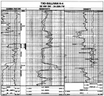
WELL: TXO Sullivan No. H-4
LOCATION: 34-26N-7W, Grant Co.
FIELD: North Vicar
DEPTH: 6043.8-6057 -- core
6042.8-6058 -- wireline log
STRATIGRAPHIC INTERVAL: Woodford, Misener, and Sylvan
WELL-LOG SUITE (Fig. B-4):
CORE DESCRIPTION (based on core depths) (Fig. B-5):
The cored interval consists of Misener in sharp contact with the overlying Woodford and underlying Sylvan Shale. A sample taken from shale below the base of the Misener yielded only a few broken conodont elements. The best preserved specimen, Plectodina, suggests a Late Ordovician age for the shale.
The sandstone interval (6045.5-6056 ft) is composed of moderately sorted, medium-grained sand. The most obvious feature of this core is the abundance of burrows and bioturbation. Some evidence of original bedding can be seen at 6045.7, 6047.2, 6050, 6051.2 and 6055 ft. At most places stylolites seemingly correspond to the original bedding surfaces. A black shale bed, 1.5 in. thick, occurs at 6055 ft. It has a sharp, undulose contact with the sand above and a sharp, straight contact with the sand below. It contains some sand lenses possibly due to burrowing. A few shale, phosphate, and chert clasts and nodules are present in the sand below the shale break at 6055 ft. The Woodford Shale is black and organic-rich.
The sharp contact of the Misener with the Woodford is marked by a ½-in. pyritized layer (contact at 6045.5 ft). The basal contact with the Sylvan Shale is sharp and irregular; it is marked by a large (2-in.) chert nodule. The Sylvan Shale is a dolomitic green-black shale.
PETROGRAPHIC ANALYSIS (Fig. B-6):
Quartz composes 73 to 85% of the sandstone. Glauconite and phosphate (apatite and collophane) are common in small amounts, averaging 1% and 4%, respectively. Chert, microcline, and plagioclase are present in trace amounts. Based on McBride's classification (1963) this sandstone is a quartzarenite.
Clay matrix is common in this sand, especially as linings of the walls of the burrows. The clay, which is primarily illite, composes as much as 10% of the rock.
Dolomite and quartz overgrowths are the common cements. Quartz overgrowths compose up to 3%. Dolomite is mainly subhedral and cloudy in appearance. It constitutes up to 15% of the rock. Chert as pore filling also occurs.
Porosity is largely secondary, due mostly to dissolution of clay matrix. Some dolomite dissolution has also occurred. Porosity values range from 1 to 7% in thin-section, and density log porosity averages 10%.
INTERPRETATION:
Shallow-marine in embayment/estuary. Abundant burrows and bioturbation suggest deposition in an area outside of significant tidal-current activity. The sharp base is probably related almost entirely to pre-Misener subaerial erosion, rather than to tidal-current erosion.
Oil- Misener, 8/83; P/27 BOPD & 125 MCFGPD & 11 BWPD, Perf (6044-54 ft), no treatment reported.