Structural framework of Southeastern Malay Basin1
Khalid Ngah2
Search and Discovery Article #10009 (2000)
1Adaptation for online presentation of part of Ph.D. Thesis submitted to Imperial College, University of London, 1990.
2Kaysham Resources SDN BHD, Kuala Lumpur, Malaysia.
Special appreciation is expressed to the management of PETRONAS and to R.C. Selley and R. Stoneley Imperial College, University of London.
Abstract
The Malay Basin is an intracratonic basin or interior fracture trough, within a relatively stable complex of the Sunda Shelf. It formed after (1) an extensional phase which represents the period of basin opening and rapid sediment accumulation, commencing from Late Cretaceous - Late Eocene to Late Miocene (2) a compressional phase in Late Miocene - Pliocene, which formed most of the domal and anticlinal features, many of which trapped hydrocarbons, and (3) an extensional phase of basin rejuvenation, with extensive marine incursion and sedimentation during Pliocene-Recent. During Late Miocene - Pliocene, the southeastern part of the basin experienced adjustment of fault blocks and subsequent faulting, which resulted in exposure of reservoirs and their diagenetic modification.
Fault trends in the northern part of the Malay Basin generally are north-south, but in the southern two-thirds, east-west- and northwest-southeast-trending lineaments are more predominant.
Structural evolution of the southern Malay Basin has resulted in its being relatively to oil-prone.
----------
List of Figures
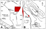
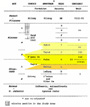 Figure 2-Composite stratigraphic scheme for southeastern Malay basin.


Click here for animation of maps from figures 5 and 16.
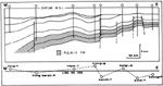 Figure 6-Generalized cross-section along seismic line B-B', showing down-step block faulting, which is common in the northeastern part of the southeastern Malay
basin. Line of section shown in Figure 16.
Figure 6-Generalized cross-section along seismic line B-B', showing down-step block faulting, which is common in the northeastern part of the southeastern Malay
basin. Line of section shown in Figure 16.
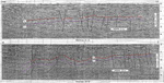 Figure 7-Seismic cross-sections A-A' and B-B', showing west and northwest thickening,
respectively. Flexure zone is to the left of each
section. Line of section shown in Figure 16.
Figure 7-Seismic cross-sections A-A' and B-B', showing west and northwest thickening,
respectively. Flexure zone is to the left of each
section. Line of section shown in Figure 16.
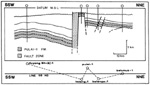 Figure 8-Generalized cross-section along D-D', showing steeply dipping fault, which trends
east-west and along which throw exceeds 1.5 km. Line of section shown in
Figure 16.
Figure 8-Generalized cross-section along D-D', showing steeply dipping fault, which trends
east-west and along which throw exceeds 1.5 km. Line of section shown in
Figure 16.
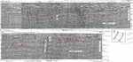 Figure 9-Seismic cross-sections C-C' and D-D', showing faulting and associated structures, including a shale(?) pillow in the central part of C-C" and a major fault zone in D-D'.
Line of section shown in Figure 16.
Figure 9-Seismic cross-sections C-C' and D-D', showing faulting and associated structures, including a shale(?) pillow in the central part of C-C" and a major fault zone in D-D'.
Line of section shown in Figure 16.


 Figure 13-Generalized cross-section along seismic line E-E'
(Figure 14), showing extensive truncation of Tertiary sediments on eastern flank of basin.
Line of section shown in Figure 16.
Figure 13-Generalized cross-section along seismic line E-E'
(Figure 14), showing extensive truncation of Tertiary sediments on eastern flank of basin.
Line of section shown in Figure 16.
![]() Figure 14-Seismic line E-E', showing extensive
eastern truncation of Tertiary strata; correlation of seismic data with well-log data, showing seismic reflectors R, B., and
P,
corresponding, respectively, to top of
Pulai-II Formation (and Terengganu Shale), top of Pulai
Sandstone, and base of Pulai Formation, which in turn show eastern flank of basin with extensive truncation.
Line of section shown in Figure 16.
Figure 14-Seismic line E-E', showing extensive
eastern truncation of Tertiary strata; correlation of seismic data with well-log data, showing seismic reflectors R, B., and
P,
corresponding, respectively, to top of
Pulai-II Formation (and Terengganu Shale), top of Pulai
Sandstone, and base of Pulai Formation, which in turn show eastern flank of basin with extensive truncation.
Line of section shown in Figure 16.
Click here for animation of maps from figures 5 and 16.


Structures in Southeastern Malay Basin
Prior to 1968 the offshore area of Peninsular Malaysia was virtually unknown, but with the participation of Esso and Conoco exploring for hydrocarbons in the region beginning in 1968 and the participation by government bodies and institutions in subsequent years, a great deal of information is now available.
Early work of Parke et al (1971) and Pupilli (1973), which focused on the descriptions and tectonics of the South China Sea, indicated the importance of both extensional and compressional stresses in the development of the basins. They proposed that the basins were formed during Late Cretaceous-Early Eocene.
Hutchison (1973) and Hamilton (1979) considered the creation of the Malay and Penyu basins (Figure 1), along with that of the Gulf of Thailand (Pattani) Basin (to the north-northwest), the West Natuna Basin (to the east of the Penyu Basin and southeast of the Malay basin), and other basins in the South China Sea, as being the result of the interaction of stresses acting on two opposite sides of the Sunda microplate. They thought that the stresses were caused by: (1) the collision of the Indian and Eurasian plates, and (2) the opening of the South China Sea through seafloor spreading.
The net effect of these stresses on the Sunda plate, which was being "sandwiched" by the northward motion of the Indian plate on the west and south, and on the east by the southward motion of the South China Sea seafloor and the Borneo landmass, was that the plate was slightly rotated clockwise, elevated, arched, and domed. Because arching created extensional stresses within the crustal landmass, it eventually fractured to form grabens and half-grabens.
Tapponier et al. (1982) suggested an alternative mechanism for the crustal buckling and fracturing in some areas of eastern Asia. Based on the experimental work on plasticine models, they proposed that extrusive tectonics was responsible for initiating crustal buckling, arching, and eventual fracturing.
Stratigraphically, Senathirajah (1969) noted the occurrences of undisturbed Jurassic-Cretaceous sediments on Peninsular Malaysia, and Haile (1970, 1973) reported on the occurrences of unmetamorphosed Tertiary sediments in the offshore islands of Anambas and Natuna. However, it was Armitage and Viotti (1977) who formally proposed the stratigraphy scheme of the Malay basin (Figure 2). Prior to their work, Esso used an informal alphabetical nomenclature, based on seismic sequence analysis, to describe the stratigraphy of the basin. Carigali (1986) utilized a new nomenclature that was more suitable in their areas of operation.
The Malay basin trends generally northwest-southeast and, as defined by the 5000-metre total sediment isopach, measures roughly 500 km in length and 100 km in width (Figure 1). On the basis of the 2000-metre contour, the basin measures more than 800 km in length and 250 km in width and extends into the Gulf of Thailand in the northwest and to Indonesia in the southeast. Seismic data quality generally deteriorate below 2.5 seconds two-way-time (TWT), and due to this and the accumulation of a very thick sedimentary pile toward the center of the basin, basement has not been recognized properly. Esso (1976) believed that the total sediment thickness exceeds 13,000 metres in the deepest parts of the basin. In the study area, the thickest sedimentary section is in the northwest, where it exceeds 10,000 metres.
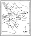
The Malay basin is an intracratonic basin or interior fracture trough (Kingston et al, 1982), within a relatively stable complex of the Sunda Shelf. The work of the Geological Survey of Malaysia (1968), Haile (1970, 1973), and Achalabhuti (1974) on the geology of Peninsular Malaysia, the offshore islands of the Sunda Shelf, and the Gulf of Thailand, respectively, suggest that this crustal Sunda landmass consists essentially of igneous and metamorphic rocks and strata of pre-Cretaceous age. Units of the Gagau Group of Late Jurassic - Late Cretaceous in age on the Peninsula (Senathirajah, 1969; Rishworth, 1974) probably extend offshore and constitute, in part, the basement of the Tertiary basin. Seismic data in the southern part of the southeastern Malay Basin illustrates truncation and steeply dipping sediments, which are thought to be part of the basement Gagau Group (Figure 3).
Three wells in the area, Belumut-1, Peta-1, and Sotong 5G-5.1, were drilled into the basement and encountered granites at Belumut-1 at a depth of 1480 metres and at Sotong 5G-5.1 at a depth of 2675 metres and metasediments at Peta-1 at a depth of 1550 metres. Two other wells outside the area, Tok Bidan-1 in the northwestern tip of the basin and Malong-1 in the south on the Tenggol Arch (between the Malay and Penyu basins), also encountered metasediments and granites, respectively.
Structures in Southeastern Malay Basin
The basin has a steeper southwest flank than the northeast flank (Figure 1). Although faults have not been detected seismically at depth, this steep basinal flank probably indicates the occurrence of some deep-seated northwest-trending faults dipping to the northeast, supporting the general description of the basin by some workers as being a half-graben.
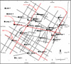
Three primary lineaments (fold and fault) have been mapped by Esso (1976). In the northern one-third of the basin, these lineaments generally trend north-south, but in the southern two-thirds, east-west- and northwest-southeast-trending lineaments are more predominant (Figures 4 & 5). Esso (1976) suggested that these lineaments were related to three phases of tectonism:
1. Extensional phase which represents the period of basin opening and rapid sediment accumulation, commencing from Late Cretaceous - Late Eocene to Late Miocene. Basin subsidence occurred through block faulting (Figures 6, 7, 8, & 9). Some of the major east-west faults observed in the study area are thought to have been related to this initial phase of basin formation (Figures 4 & 5).
2. A compressional phase in Late Miocene - Pliocene, which formed most of the domal and anticlinal features, many of which trapped hydrocarbons. Some of these features and faults in the area are thought to be associated with readjustments of fault blocks and shale(?) pillows and/or diapirs(?) (Figures 10, 11, & 12). Many of the anticlinal folds appear to be in en echelon patterns and, although wrench faults have not been mapped or are difficult to prove on seismic sections, the occurrence of en echelon features probably indicate deep-seated wrench movements. The readjustment of the fault blocks in the south and southeast, which led to uplifting, tilting, and subsequent erosion (Figures 13 & 14), is manifested in the basement being relatively shallow. This study indicates that at least some 800 metres of sediments in some areas of southeastern Malay Basin have been eroded. While in the east the basement was being elevated and subjected to erosion (Figures 13 & 14), in the western part of the area, apparently deposition of the sediments was uninterrupted. This phase was followed by:
3. An extensional phase of basin rejuvenation, with extensive marine incursion and sedimentation during Pliocene-Recent. It would appear locally, however, that some of the domal and/or anticlinal features continued to grow for sometime during this period, and it is thought that this persistent structural growth was caused by basement readjustments that triggered the more ductile sediments, probably shale, to "flow" (Figures 9, and 11).
A number of oil and gas fields are located in the southeastern part of the Malay Basin. Both oil and gas are produced primarily from sandstones of Late Oligocene to Middle Miocene age on structural features. In the north and northwestern areas, the hydrocarbon-bearing sandstones are of Middle to Late Miocene age, and they too produce from structural traps. Structural evolution of the southern Malay Basin has been relatively favorable to oil generation and entrapment.
In the southeast, the primary hydrocarbon-bearing sandstones are from the Bekok (Unit IVA), Tapis (Unit III), and Pulai (Unit IIB-IIA upper) formations of Late Oligocene-Middle Miocene age (Figure 2). Of the twelve producing fields in the area shown in Figure 5, only five--Pulai, Bekok, Seligi, Kepong, and Tinggi--are producing hydrocarbons from the Tapis (Unit III) and Pulai (Unit IIB-IIA upper) Formations at depths between 1200 and 2200 metres. The others are producing hydrocarbons from the Bekok (Unit IVA) and Tapis (Unit III) Formations at depths between 1500 to 2000 metres. Hydrocarbons have also been found in the Bekok Formation (Unit IVA) and the Seligi Formation (Unit IIA lower) at Sotong, Duyong, Besar, Angsi, Ophir, and Ledang. At Sotong, a significant hydrocarbon accumulation was found in the Pulai Formation (Unit II) at depths of 2000 to 2500 metres.
Achalabhuti, C., 1974, Petroleum geology of Gulf of Thailand (abs.): AAPG Bulletin, v. 58, p. 1430.
Armitage, J.H., and C. Viotti, 1977, Stratigraphic nomenclature, southern end Malay basin: Indonesian Petroleum Association, Sixth Annual Conv., Jakarta, Preprint 43 p.
Carigali, 1985, Structures in PM 12 Operating Area: unpublished company report.
Carigali, 1986, Stratigraphic scheme for hydrocarbon exploration in Carigali's operating areas, offshore Peninsular Malaysia: unpublished company report.
Esso, 1976, Structural development of the Malay basin: unpublished contractor's report to PETRONAS.
Haile, N.S., 1970, Notes on the geology of the Tambelan, Anambas, and Natuna islands, Sunda Shelf, Indonesia: United Nations ECAFE-CCOP Tech. Bulletin, v. 3, p. 55-75.
Haile, N.S., 1973, The geomorphology and geology of the northern part of the Sunda Shelf and its place in the Sunda mountain system: Pacific Geology, v. 6, p. 73-90.
Hamilton, W., 1979, Tectonics of the Indonesian region: U.S. Geological Survey, Professional; Paper no. 1078, 345 p.
Hutchison, C.S., 1973, Tectonic evolution of Sundaland--a Phanerozoic synthesis: Geol. Soc. Malaysia Bulletin, v. 6, p. 61-86.
Kingston, D.R., C.P. Dishroon, and P.A. Williams, 1983, Global basin classification system: AAPG Bulletin, v. 67, p. 2175-2193.
Magara, K., 1976, Water expulsion from clastic sediments during compaction--directions and volume: AAPG Bulletin, v. 60, p. 543-553.
Ngah, K., 1975, Stratigraphic and structural analyses of the Penyu basin, Malaysia: unpublished M.S. Thesis, Oklahoma State University, 52 p.
Parke, M.L., K.O. Emery, R. Szymankiewiez, and L.M. Ronalds, 1971, Structural framework of continental margin in South China Sea: AAPG Bulletin, v. 55, p. 723-751.
Pupilli, M., 1973, Geological evolution of South China Sea area--Tentative reconstruction from borderland geology and well data: Second Indonesian Petroleum Assoc. Conv., Jakarta, Preprint, 22 p.
Rishworth, D.E.H., 1974, The Upper Mesozoic terrigenous Gagau Group of Peninsular Malaysia: Geol. Survey Malaysia Spec. Paper 1, 78 p.
Senathirajah, S., 1969, Younger Mesozoic sedimentary rocks, State of Johore, West Malaysia: AAPG Bulletin, v. 53, p. 2187-2194.
Tapponier, P., G. Peltzer, A.Y. LeDain, R. Amijo, and P. Cobbold, 1982, Propgating extrusion tectonics in Asia--new insights from simple experiments with plasticine: Geology, v. 10, p. 611-616.
Depth Conversion
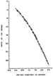
The depth sampling of the three seismic markers along a particular seismic section was made at every 1.5 to 3.0 km distance. Depth conversion of the seismic markers from TWT in seconds to metres was accomplished through the extrapolation from an average velocity-depth curve (Figure 15). This velocity curve was obtained by plotting the checkshot well velocity survey data of Angsi-1, Duyong Barat-1 Ophir-1, Tinggi-1, Banggol-1, and Palas-1, representing the south, central, east, and northwestern parts of the area. Although this method of depth conversion has inherent inaccuracies, adequate well coverage enabled depths of the markers to be determined to check consistency and accuracy of the conversion.
The structure map (Figure 5) from seismic and well-log data (Figure 16) was constructed on top of the Blue seismic marker (top of Pulai Sandstone).
The technique to determine maximum depth of sediment burial was based on the concept that the degree of compaction in shale beds, unless otherwise affected by overpressures, is related to the depth of burial (Magara, 1976). Because the velocity in these beds is approximately a direct function of compaction, sonic log was used to measure the degree of compaction. Ideally, the determination of compaction trend is best achieved in an area known to have undergone normal compaction burial, little or no tectonism, and no history of overpressuring.
The occurrences of unconformities, faults, and folds suggest that the southeast Malay Basin was tectonically unstable; therefore, it is very difficult to obtain a reasonable shale compaction trend and, subsequently, to predict the maximum depths of burial. It is thought that the best approach is to determine these depths with reference to a point in the area that is thought to have undergone relatively little tectonic uplift. The seismic data indicate that the vicinity of the Banggol-l was relatively stable; consequently, Banggol-1 was chosen as a reference point for generating a shale compaction curve by plotting the shale transit time with depth (Figure 17). Similarly, shale compaction curves were generated for other wells in the study area. In generating the compaction curves, an assumption was made that the sequence penetrated by the wells was normally pressured. However, this assumption is not generally true, as many drilling hazards in the study area have been associated with overpressuring in shales. In depth-transit time plot, it was considered, therefore, that any points to the right of the compaction curve denotes overpressuring.
In estimating depths of burial, a simple overlay technique and curve offset were used (Figure 18). The compaction curves of different wells were compared with the reference curve of Banggol-1, and any offsets in the trend were noted. The displacement of the curve to the left of the reference curve indicates that the stratigraphic interval in question was buried at some point deeper than its present-day depth. A break in the compaction curve signifies a possible unconformity. The fragmented curve was then synchronized with the reference curve, and the depth of burial and amount of section lost due to erosion, if any, determined. For example, at Pulai-1, it is estimated that uplift amounted to 300 metres, with 230 metres of erosion. Where the resultant compaction curve superimposes onto the reference curve, it was considered that the stratigraphic interval at that locality was never buried deeper than its present-day depth.