SHELL REPORT: SAND
FACIES AND THEIR ![]() ENVIRONMENTS
ENVIRONMENTS![]() IN NW GULF OF MEXICO
IN NW GULF OF MEXICO
H. A. BERNARD, C. F. MAJOR, and B. S. PARROTT
Search and Discovery Article #60002 (1999)
GEOLOGICAL MISCELLANEOUS- 16; HOUSTON, TEXAS,
SEPTEMBER 1958 ![]()
PROPERTY OF SHELL DEVELOPMENT COMPANY. The information contained herein is considered confidential by Shell Development Company. Exportation of this document is subject to license under the Export Control Act of 1949.
TABLE OF CONTENTSIllustrations
Abstract
Introduction
Classification of ![]() Environments
Environments![]() of the Northwestern Gulf of
Mexico
of the Northwestern Gulf of
Mexico
Continental ![]() Environments
Environments![]()
Transitional ![]() Environments
Environments![]()
Normal Marine ![]() Environments
Environments![]()
Alluvial ![]() Environments
Environments![]()
Meander Belt
Point Bar
Sequence
in Grain Size
SP
Character
Sequence
in Sedimentary Features
Small
Ripple Bedded Features
Horizontally
Bedded Features
Giant
Ripple Bedded Features
Poorly
Bedded Features
Gradational
Zonation in Sequence of Sedimentary Features
Miscellaneous
Sedimentary Features
Organic
Remains
Directional
Features
Cross
Bedding
Grain
Orientation
Geometry,
Size, and Prediction in Trend
Abandoned Channels
Flood Basin or Backswamp
![]() Deltaic
Deltaic![]()
![]() Environments
Environments![]()
Classification of Deltas
Genesis of a Delta
![]() Deltaic
Deltaic![]() Subenvironments and the
Mississippi Delta
Subenvironments and the
Mississippi Delta
![]() Deltaic
Deltaic![]() Plain
Plain
Pro ![]() Deltaic
Deltaic![]() Plain
Plain
Pro ![]() Deltaic
Deltaic![]() Plain Fringe
Plain Fringe
Pro ![]() Deltaic
Deltaic![]() Plain Distal
Plain Distal
![]() Deltaic
Deltaic![]() Foraminiferal Assemblages
Foraminiferal Assemblages
Generalized ![]() Deltaic
Deltaic![]() Sediment
Distribution
Sediment
Distribution
![]() Deltaic
Deltaic![]() Plain
Plain
Pro ![]() Deltaic
Deltaic![]() Plain
Plain
Sedimentary Features Common to ![]() Deltaic
Deltaic![]() Deposits
Deposits
![]() Deltaic
Deltaic![]() Plain
Plain
Distributary
Channel Fill and Natural Levee
Point
Bar
Flood
Basin
Pro ![]() Deltaic
Deltaic![]() Plain
Plain
Fringe
Distal
Other Features in the
Mississippi ![]() Deltaic
Deltaic![]() Area
Area
Geometry and Sequence of Sedimentary
Features
Mississippi-St.
Bernard Subdelta
Pleistocene
Mississippi-Neptune Delta
Sequence of Fringe
Deposits and SP Log Character
Sequence of Channel
Fill Deposits and SP Log Character
Sequence of ![]() Deltaic
Deltaic![]() Point Bar and Other Deposits
Point Bar and Other Deposits
Bar Finger
"Sands" of Fisk
Brazos and Rio Grande Deltas
Pro ![]() Deltaic
Deltaic![]() Plain
Plain
Sequence
and SP Log Character
![]() Deltaic
Deltaic![]() Plain
Plain
Meander
Belt
Flood
Basin
Wood
and Fauna
Sequences
and SP Log Character
Interdeltaic-Marine and Marine ![]() Environments
Environments![]()
Galveston Barrier Island and Associated
![]() Environments
Environments![]()
Genesis
Bottom Sediments
Sedimentary Features
Sequence
SP Log Character
Foraminiferal
Assemblages
Directional Features
Geometry
Transgressive Beach and Associated
Regressive Mud Flat
Environment
Genesis, Geometry,
and Nature
Directional Features
Marine ![]() Environments
Environments![]() and Shelf Sands
and Shelf Sands
Summary
Bibliography
LIST OF ILLUSTRATIONS
Figure
- Occurrence of Recent depositional
 environments
 in the
northwestern Gulf of Mexico.
in the
northwestern Gulf of Mexico. - Classification of depositional environments of the
northwestern Gulf of Mexico.
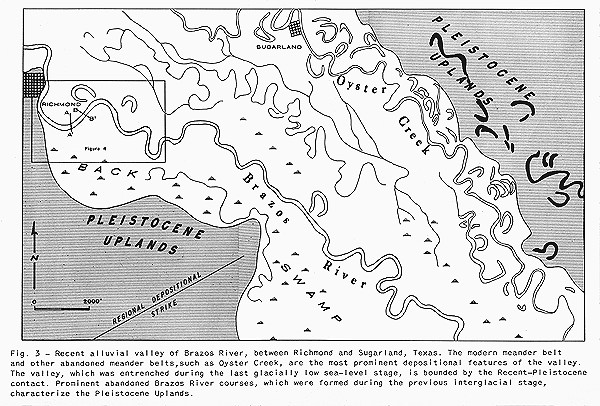
- Recent alluvial valley of the Brazos River near Richmond, Texas.
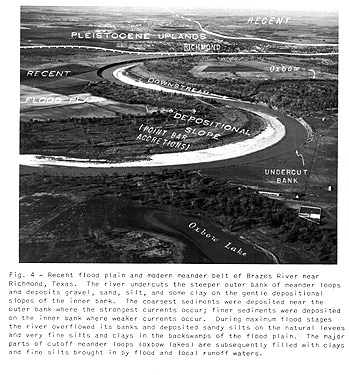
- Brazos meander belt near Richmond, Texas.
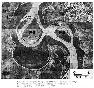
- Alluvial valley environments.
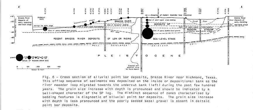
- Cross section of Brazos point bar deposits near Richmond, Texas.
- Cross sections of small-scale ripple bedded, point bar sands.
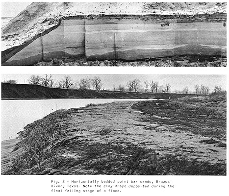
- Horizontally bedded point bar sands.
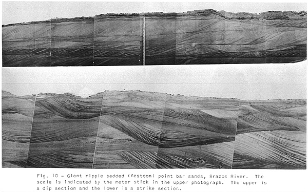
- Giant ripples and giant ripple bedded point bar sands.
- Giant ripple bedded sands.
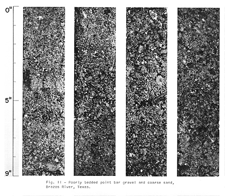
- Poorly bedded, point bar gravel and coarse sand.
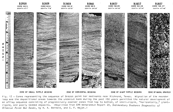
- Sequence of bedding features found in point bar deposits.
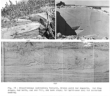
- Miscellaneous sedimentary features of point bar deposits.
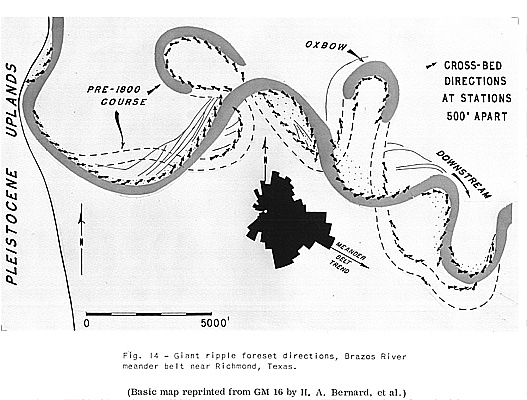
- Giant ripple foreset directions in Brazos point bar deposits.
- Dip directions of foreset beds in zone of giant ripple bedded sands of a Brazos point bar.
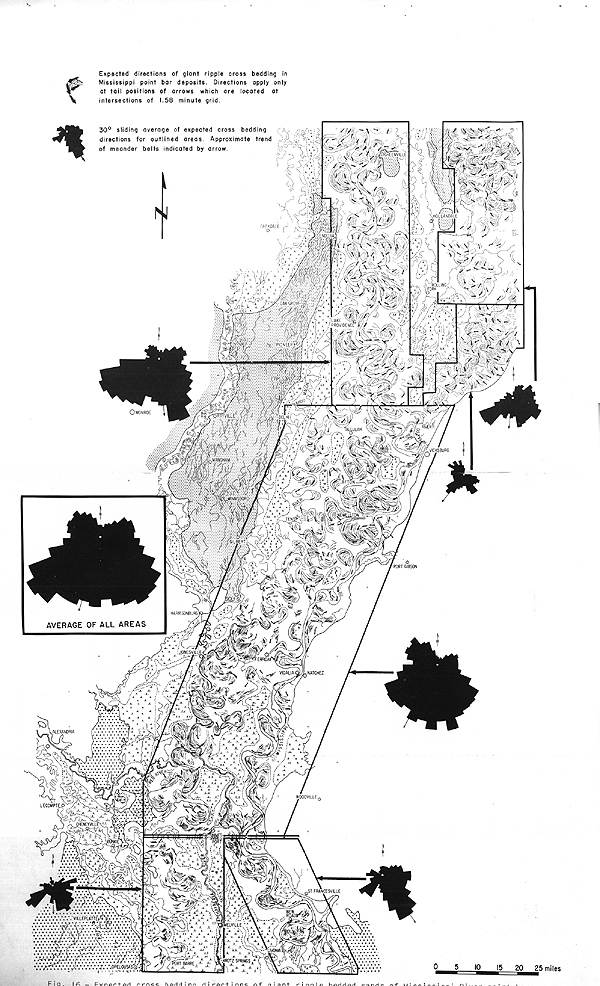
- Expected cross bedding directions of giant ripple bedded sands of Mississippi point bars.
- Grain orientation in horizontally bedded sands of a point bar deposit.
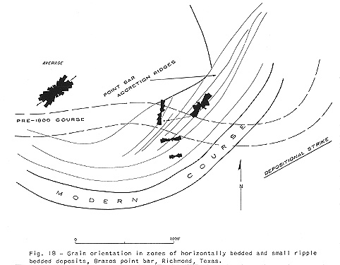
- Grain orientation in horizontally bedded and small ripple bedded deposits of a point bar deposit.
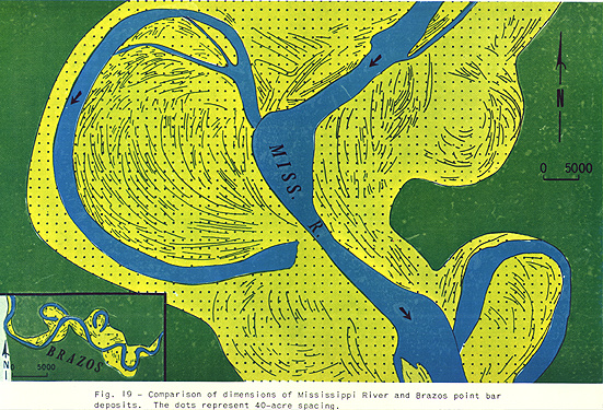
- Comparison of Mississippi and Brazos point bar deposits.
- Typical world deltas.
- Typical world deltas.
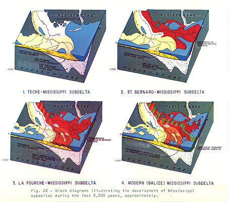
- Block diagrams illustrating the development of Mississippi subdeltas.
- Mississippi deltaic environments.
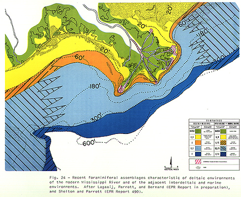
- Distribution of foraminiferal biofacies in the Mississippi Delta Area.
- Bottom sediment distribution, vicinity of Mississippi Delta.
- Distribution of Mississippi deltaic deposits
characterized by sedimentary features.
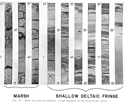
- Marsh and shallow fringe deposits of the Mississippi Delta.
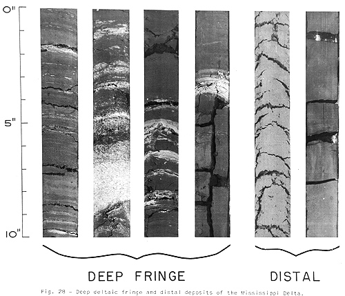
- Deep fringe and distal pro deltaic plain deposits.
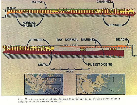
- Cross section of St. Bernard-Mississippi Delta.
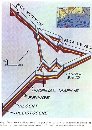
- Fence diagram of a Pleistocene Mississippi Delta.
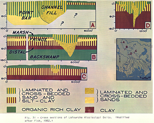
- Cross sections of LaFourche-Mississippi Delta.
- Sedimentary framework, modern Mississippi Delta.
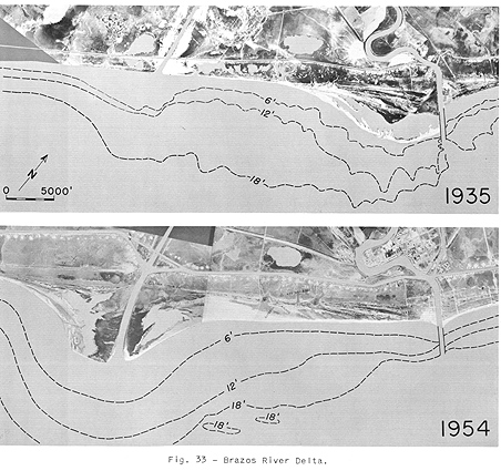
- Brazos River Delta.
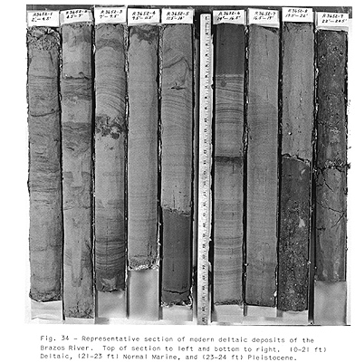
- Representative section of modern deltaic deposits of
the Brazos River.
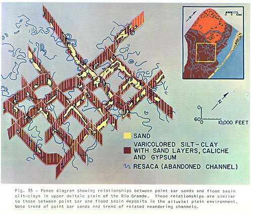
- Fence diagram of the Rio Grande Delta. .
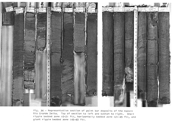
- Representative section of point bar deposits of the Rio Grande Delta.
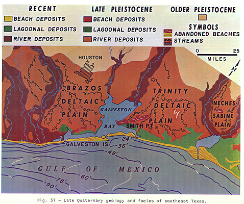
- Late Quaternary geology and facies of southeast Texas.
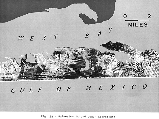
- Galveston Island beach accretions.
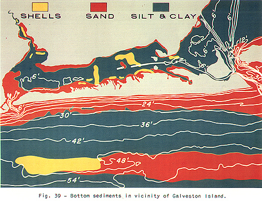
- Bottom sediments in vicinity of Galveston Island.
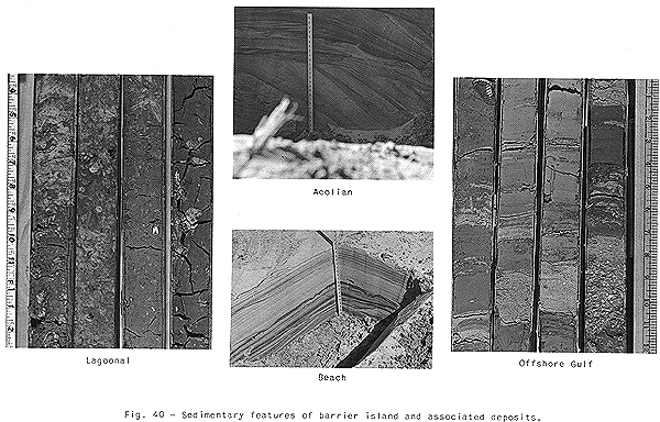
- Sedimentary features of deposits in vicinity of barrier islands.
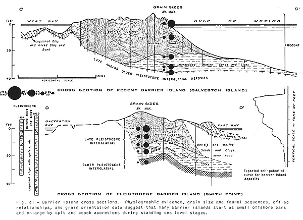
- Cross sections of barrier island deposits.
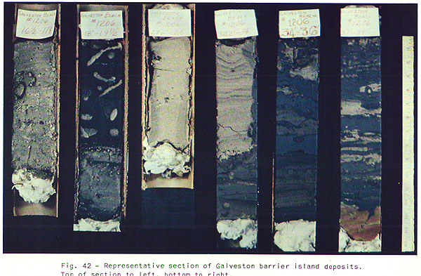
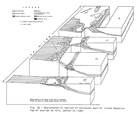
- Representative section of Galveston barrier island deposits.
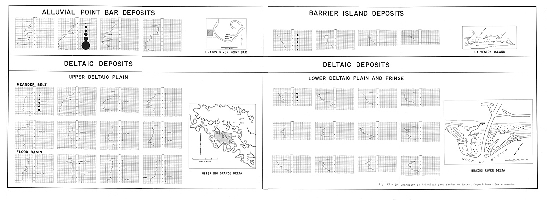
- SP character of principal sand facies of Recent
depositional environments
 .
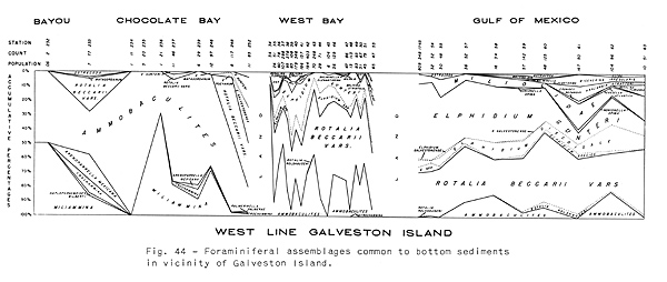
. - Foraminiferal assemblages in the vicinity of Galveston Island.
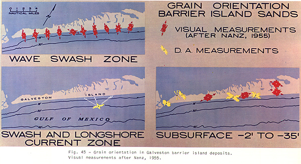
- Grain orientation in Galveston barrier island deposits.
- Block diagram of Galveston barrier island deposits.
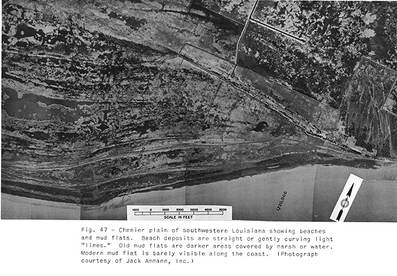
- Chenier plain of southwestern Louisiana showing beaches and mud flats.
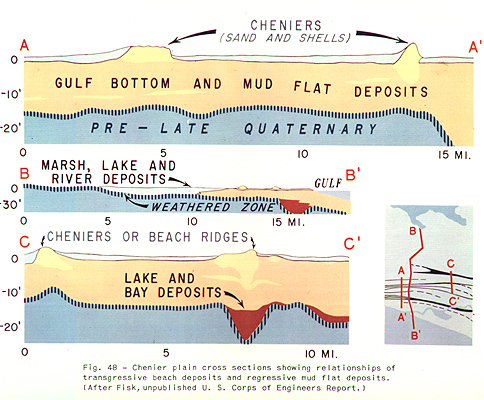
- Chenier plain cross sections of transgressive beach and regressive mud flat deposits.
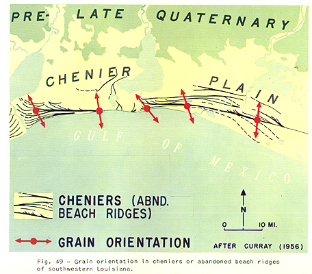
- Grain orientation in cheniers or abandoned beach ridges.
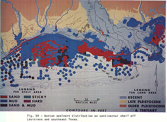
- Bottom sediment distribution on continental shelf off Louisiana and southeast Texas.
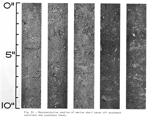
- Representative section of marine shelf sands off southwest Louisiana and southeast Texas.
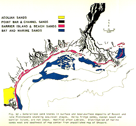
- Trends of Recent and late Pleistocene sand bodies of coastal Louisiana and Texas.