INTERDELTAIC-MARINE AND MARINE ENVIRONMENTS
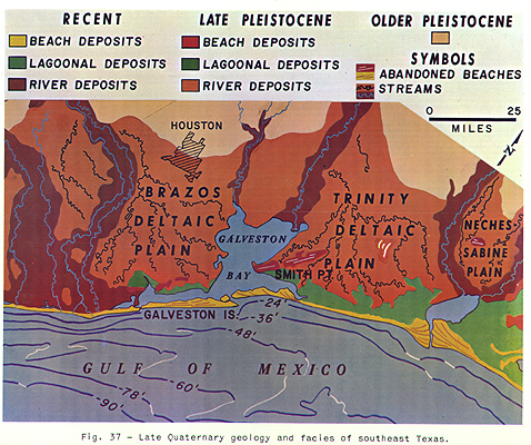
The better developed sand bodies of the coastal interdeltaic marine environments along the Texas-Louisiana coast are regressive barrier island and transgressive beach sands (see Price, 1951). The Recent interdeltaic-marine environment shown in Figure 37 extends eastward along the coast from the western end of Galveston Island. It includes the beaches and barrier islands represented by yellow, the marshes represented by green, and the bays, lagoons, and the very shallow Gulf, offshore to the 30- or 40-foot contour, represented by a portion of the blue. For more details see LeBlanc (1950), EPR MSPR January 1955, Item 21004, and EPR Geol. Misc. 1, revised May 1958.
Galveston Barrier Island and Associated Environments
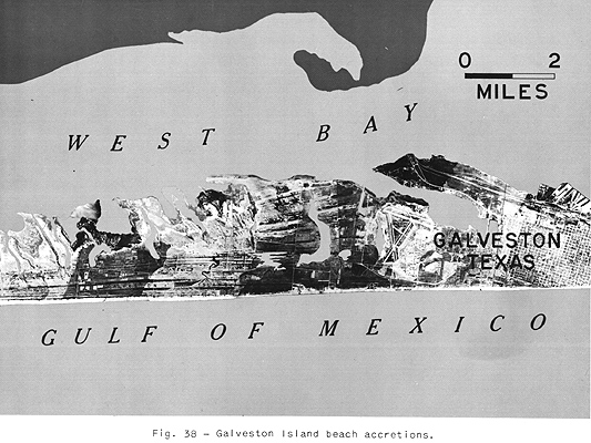
Galveston Island is a typical barrier island. It began as a small offshore bar at the beginning of the standing sea-level stage about 6000 years ago. Physiographic studies suggest that it emerged as an island and grew gulfward by beach accretion, and southwestward, in the direction of the prevailing longshore drift, by spit accretion during the present standing sea-level stage (Figure 38). The parallel beach ridges and swales on the photograph record its seaward growth. Radiocarbon dates of the shells, the offlap relationships of the facies, the sequence of grain sizes and fauna, and other data support this history of the development of the Galveston barrier island.
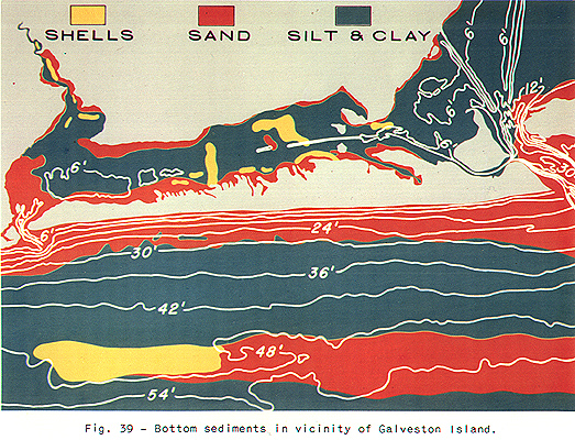
The surface of the island consists of very well sorted fine to very fine sand. This sand, containing shells, extends seaward along the gulf bottom, decreasing in grain size from fine to very fine sand, to the break in offshore slope near the 30-foot contour. Seaward of this contour the bottom consists of silt and clay with shells, except for the sand and shell bottom on the small topographic high (see Figure 39). The distribution of the sediment on the seaward side of Galveston Island is related to the offshore profile of equilibrium (Figure 41). Sand also fringes the back side of the island and the mainland and is the dominant sediment in the tidal channels and tidal deltas. Silt, clay, and shells make up most of the bottom sediment in the open parts of the bay and lagoon.
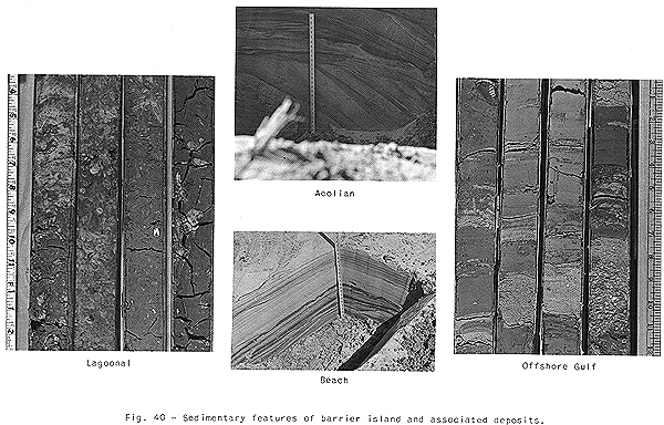
The sedimentary features are a distinct aid in distinguishing the facies of the Galveston barrier island and environs. As illustrated by the three cores on the left of Figure 40, the lagoonal or bay deposits are burrowed and churned by organisms. The contact with the Pleistocene occurs near the bottom of the third core from the left. Horizontal lamination and very low angle cross bedding, which may be burrowed and churned by organisms (Figure 40, third core from right), are the more common features of the back shore, beach crest, and fore shore deposits. Aeolian deposits, forming the uppermost barrier island deposits, are variably cross bedded (festooning may be common), horizontally laminated, contorted, and burrowed. Aeolian deposits may vary in thickness from a few inches to more than 40 feet along the Texas coast. The bottom deposits from the beach gulfward to the break in offshore slope consist of burrowed, churned, massive, bedded,laminated, and occasionally cross bedded sand and shells. In general, the bedding conforms with the slope of the beach. Cross bedding is very rare in the offshore sands. The deposits seaward of the break in offshore slope are interbedded and burrowed sand and silt-clay with shells (Figure 40, two cores on right). Thin graded beds of sand and coarse silt have been observed. If the bottom currents were weaker and less frequent, burrowing and churning by organisms would be more common.
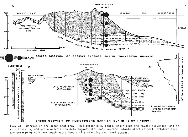
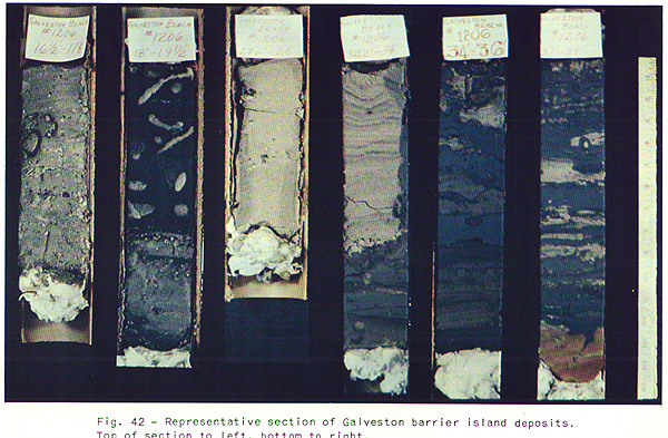
Sections across Galveston Island reveal an offlap sequence of deposits which agrees with the seaward growth of the barrier during the standing sea-level stage (Figure 41). The barrier island sand body offlaps the interbedded deposits. The vertical sequence of sedimentary features from top to bottom, left to right in Figure 42, repeats the offshore sequence of sedimentary features. Burrowed, churned, massive, bedded, and laminated sand containing shells overlies interbedded and burrowed sand and silt-clay with shells. The Recent-Pleistocene contact is on the extreme right.
The sequence of a Pleistocene barrier island (Smith Point) is also illustrated in Figure 41. (See Figure 37 for location of Smith Point, which is the red area on the east side of Galveston Bay.) The vertical row of dots through the barriers represents the decrease in median and maximum grain size with depth in the barrier. This grain size decrease with depth repeats the grain-size decrease on the gulf bottom sediments off Galveston Island.
Because the vertical grain size decreases with depth and there
are no clay layers in the upper portion, a smooth funnel-shaped
log such as in R-3656, Figure 43, should
be typical for barrier island deposits resulting from seaward
accretion processes. A barrier island sequence resulting from an
offlap filling of a tidal channel or pass such as at the western
end of Galveston Island may have a bell-shaped character such as
illustrated by R-3687, Figure 43. Many
tidal channel deposits consist of coarser lag sediments and
should be represented by an SP log having a more blocky shape.
R-3688 and R-3689 (Figure 43) are SP logs
of borings on the back side of Galveston Island. These logs are
serrate-funnel shaped and record the intermittent accretionary
growth of the island lagoonward from sand washed over or blown
over the island during storms. Finer grained silts and clays are
deposited slowly in the lagoons between storms. These logs are
similar to those of deltaic plain fringe deposits. However, there
is generally much more silt and clay in deltaic fringe deposits,
especially for birdfoot and lobate type deltas. See EPR Geol.
Misc. 1, revised May 1958.
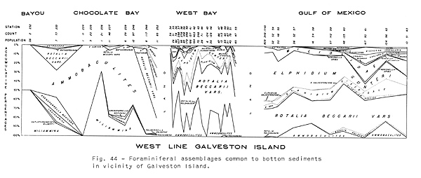
Arenaceous Foraminifera characterize the marsh and near-marsh sediments. Calcareous Rotalia and Elphidium characterize the open lagoonal sediments (Figure 44). Rotalia and Elphidium plus a few open gulf Foraminifera characterize the sediments accreting to the shallow gulf side of the barrier. The sequence of assemblages with depth in borings through Galveston repeats the offshore sequence of foraminiferal assemblages.
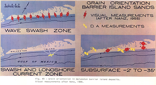
The subsurface trend of a barrier island may be recognized early by grain orientation (Figure 45) (Nanz, 1955). The grain orientation of beach sands is determined by the to-and-fro action of waves and is therefore perpendicular to the beach trend. Offshore from the beach, longshore currents orient sand grains parallel to the beach trend. It appears that because much of the barrier island mass consists of a seaward offlap sequence of deposits, the grain orientation of the subsurface sands of Galveston Island is parallel to the trend of the barrier. Grain orientation in barrier island sands deposited as a result of hooked spit accretion and wash-over fans is being studied and will be reported in the near future.
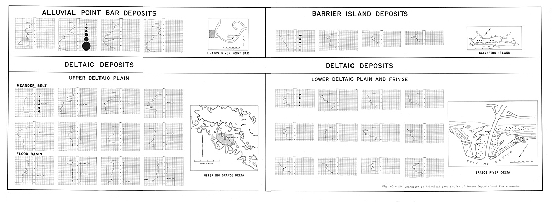
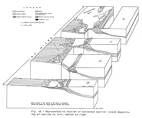
Barrier island sands range from 15 to 50 feet in thickness (see Fig. 46). Aeolian sands may increase the thicknesses of barrier island sands to more than 90 feet. Barrier islands are relatively narrow, from approximately 1/2 to over 8 miles wide. They are relatively long, from a few miles to over 50, and are parallel to the regional depositional strike. A chain of Recent barriers connected by tidal channel and tidal delta deposits extends a distance of over 300 miles along the Texas and Mexican coastlines. Adjacent chains of barrier island sands like the Recent and the late Pleistocene (Beaumont) Live Oak and Smith Point chain along the Texas and Mexican coasts may occur in the same "stratigraphic" position adjacent to each other or separated by lagoonal and marine deposits.
Transgressive Beach and Associated Regressive Mud Flat Environment
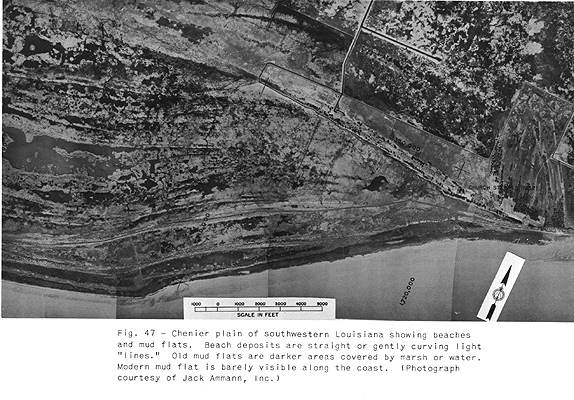
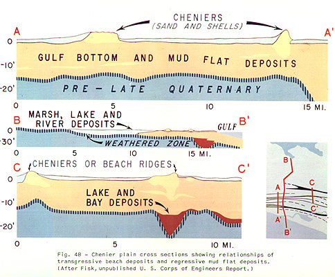
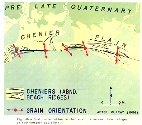
The coastal interdeltaic-marine environment in southwestern Louisiana includes a regressive "chenier" plain which accreted to the coast during the standing sea-level stage (Figure 47). See LeBlanc (1949 and 1950). The sedimentary facies consist of coastal mud flat deposits and abandoned beach or chenier sands (Figure 48). The mud flat deposits are overlain by marsh deposits. The coastal mud flats accreted to the coast when shore currents were weak and an abundant supply of silt and clay was available. The seaward-most margins of the mud flats were transgressed slightly by beaches when the supply of silt and clay decreased and waves and currents were stronger. The transgressive beach deposits are narrow and are only as thick (12 feet) as the height (above sea level) which waves can pile beach debris. Some beaches are continuous for over 20 miles.
The beach deposits consist of very well sorted fine sands and shells. Both horizontal and very low angle cross bedding may occur. Burrowings may be common.
Because these transgressive beach deposits were constructed in the zone of considerable wave action, Curray (1956) found that the grain orientation in these beach deposits is perpendicular to the beach trend (Figure 49). On the other hand, Nanz (1955) has pointed out that grain orientation in the middle and basal parts of regressive barrier island sands is parallel to the long axis of the island (Figure 45).
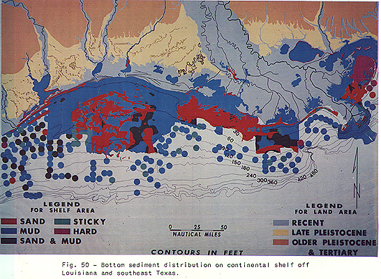
Marine Environments and Shelf Sands
Little detail is known about the marine sands of the Gulf since these are difficult to core (see Figure 50). Available data strongly support the theory that the occurrence of sands in the normal marine environments is controlled to a large extent by the occurrences of underlying Recent and Pleistocene deltaic and other shoreline sands. Deltas, barrier islands, and beaches when transgressed (LeBlanc and Bernard, 1952) form shoals or banks on which winnowing by waves and currents is the dominant marine process. Shoals or banks blanketed with sand along the Louisiana coast resulted from transgressions of the subsiding seaward parts of the Teche and St. Bernard deltas during the latter part of the standing sea-level stage. The occurrence of Recent marine sands in the Sabine Bank area (west of center of Figure 50) is due to the winnowing of the upper part of Pleistocene Mississippi deltaic sediments during the present standing sea-level stage and the last rising sea-level stage.
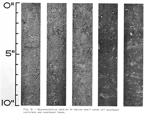
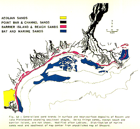
According to our data these sands are patchy, thin, and dirty and contain numerous shell fragments (Figure 51). Considerable amounts of bioclastics accumulate mostly on the seaward sides of the prominent shoals or banks. Well-developed lenticular sand bodies, such as Sabine Bank proper (a few miles off Sabine Pass), are believed to be former barrier islands or beaches which formed during minor still stands of the last rising sea-level stage. Sands on the middle and outer shelf, near the 600-foot contour of Figure 52, are believed to be reworked former shoreline sands which were deposited during the lower sea-level stage.
![]()